

Douglasville, Georgia
Encyclopedia
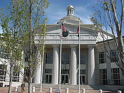
County seat
A county seat is an administrative center, or seat of government, for a county or civil parish. The term is primarily used in the United States....
of Douglas County, Georgia
Douglas County, Georgia
Douglas County, Georgia has been experiencing numerous natural disasters over the most recent decades. Being located in the South Eastern United States the county experiences strong storms and tornadoes often because of its location in Dixie Alley....
, United States. As of the 2010 census, the city had a population of 30,961. Douglasville is located approximately 20 minutes west of Atlanta, Georgia and is included in the Atlanta Metro Area.
Highway access can be obtained via five interchanges along Interstate 20
Interstate 20
Interstate 20 is a major east–west Interstate Highway in the Southern United States. I‑20 runs 1,535 miles from near Kent, Texas, at Interstate 10 to Florence, South Carolina, at Interstate 95...
.
History
Located at a natural rise in the topography, Douglasville was originally known as Skint Chestnut. The name derived from a large tree used by Indians as a landmark, which was stripped of its bark so as to be more conspicuous.The Town of Douglasville was established by the Georgia General Assembly on February 25, 1875. The boundaries were as follows: The center shall be a point directly opposite the court house in said town, on the Georgia Western Railroad, thence running along the center of said road each way three-fourths of a mile, and extending one half mile each way from the center of said road, the form of said territory to be an oblong square.
An election was held on the first Saturday in March, 1875, and a mayor, treasurer, records (secretary), and marshal were chosen.
In 1916 the Reverend Atkinson of Douglasville was a key figure in the Arc Light Controversy
Arc Light Controversy
The Arc Light Controversy raged between neighbors in what is now the Virginia Highland neighborhood of Atlanta, Georgia, and was front-page news in late January and early February 1916....
in Atlanta.
Natural Disasters
Douglasville, Georgia has experienced numerous natural disasters over the most recent decades. Being located in the South Eastern United States, the city experiences strong storms and tornadoes often because of its location in Dixie Alley. Its close proximity to the Gulf of Mexico and the Atlantic Ocean also makes the area prone to hurricane outer bands or remnants.Tropical Storm Alberto was a strong tropical storm at landfall in northwest Florida and Southwest Georgia in early July, 1994. Its remnants affected the metro Atlanta area with some damage.
Hurricane Katrina
Hurricane Katrina
Hurricane Katrina of the 2005 Atlantic hurricane season was a powerful Atlantic hurricane. It is the costliest natural disaster, as well as one of the five deadliest hurricanes, in the history of the United States. Among recorded Atlantic hurricanes, it was the sixth strongest overall...
's remnants ripped through the area spawning tornadoes, widespread wind damage, and flooding rains. Katrina killed two people in Georgia
The county has suffered through numerous ice storms throughout the years which are fairly common. The ice storms bring everything to a stand still in the area due to the lack of equipment to deal with the problem and drastic amounts of power outages. Some of the worst ice storms were in 1938, 1994, 1998, 2000, 2005, and 2010.
The Storm of the Century (1993) in March of 1993 brought 17 inches (432 mm) of snow to Douglasville, with drifts measuring several feet.
In 2007 the city suffered one of the worst droughts in the areas history, causing a complete watering ban and resulting in the largest wildfire in Georgia history. The fire was located in south east Georgia, but it still affected the county with smoke often through the life of the fire.
On September 21, 2009 Douglas County was devastated by the worst flood in Georgia history. Over 18 inches (457 mm) of rain fell in one night, causing many roads to be destroyed and many homes a total loss. The county was later declared a disaster area, and the governor of Georgia declared a state of emergency. The flooding most affected the areas of Douglasville, Villa Rica, Austell, Lithia Springs, and Chapel Hill. The disaster killed more than eight people in the county, most of them in the Douglasville area. The Austell death toll was also high but it was reported in the Cobb County losses.
In 1995 the county sustained significant damage from Hurricane Opal
Hurricane Opal
Hurricane Opal was a Category 4 hurricane that formed in the Gulf of Mexico in September 1995.Opal was the ninth hurricane and the strongest of the abnormally active 1995 Atlantic hurricane season...
. The hurricane had strong winds and heavy rain that caused some damage to some structures in the area and flooded low lying areas.
A tornado touched down in Douglasville on March 7, 2008 in the Chapel Hill area. The tornado was small but caused some damage. A Kroger Grocery store was damaged by the storm, many trees fell and some homes in the surrounding area were damaged. One home in the Brookmont subdivision, the hardest hit subdivision by the storm, was ripped in half exposing the whole inside of the home. Arbor Place Mall in Douglasville reported a window blown out by the storm. Only one person was injured by the tornado.
Another tornado touched down in the Douglasville area on May 11, 2008, causing damage throughout Douglas County. The EF2 tornado awoke many people in their sleep on Mother's Day morning. The tornado touched down in the Fairplay area and moved through the county. Damage was reported sporadically throughout the county. The storm that moved through destroyed homes, downed trees and destroyed a gas station in Douglasville with its roof being thrown into the street. There were no injuries or deaths from the tornado. Residents say that the counties tornado sirens were sounded before the tornado touched down. This is the first time in history that two tornadoes have touched down in Douglas County in the same year. The Governor of Georgia declared a state of emergency for Douglas County and many other counties in the state on May 12, 2008.
On January 4, 2011, a Norfolk Southern train sped through downtown Douglasville, around 1 am, causing several cars to get derailed, which caused part of Highway 78
U.S. Route 78
U.S. Highway 78 is an east–west United States highway that runs for 715 miles from Memphis, Tennessee, to Charleston, South Carolina. Between Memphis and Birmingham, Alabama, it is being upgraded to become Interstate 22....
and Strickland Street to be closed due to debris. The mess was cleaned up quickly, and luckily none of the downtown buildings were affected. The trains started going through Douglasville again, Wednesday morning; there were no casualties or injuries.
On the night of February 12, 2010, the area was affected by a snowstorm. The area accumulated close to 7 inches (178 mm) of snow, which is more than residents of the area are normally used to. It brought Douglas County to a standstill for a few days causing severe black ice patches throughout the area. It took over a week for all the snow and ice to melt which is unusual for the area, but it gave everybody a little bit of fun in what had been a very gloomy month.
Sunday night of January 9, 2011, right after Douglasville's first white Christmas
White Christmas
A white Christmas refers to the presence of snow on Christmas Day. This phenomenon is most common in the northern countries of the Northern Hemisphere...
in decades, a snowstorm developed over Douglas County and caused as much as 8 inches (203 mm) of snow in the area. The storm closed grocery stores, the courthouse, and arbor place mall until that Wednesday January 12. Schools were closed the entire second week of January.
Geography
Douglasville is located at 33°44′59"N 84°43′23"W (33.749824, −84.723190).According to the United States Census Bureau
United States Census Bureau
The United States Census Bureau is the government agency that is responsible for the United States Census. It also gathers other national demographic and economic data...
, the city has a total area of 21.5 square miles (55.7 km²), of which 21.4 square miles (55.4 km²) is land and 0.1 square mile (0.258998811 km²) (0.60%) is water.
Douglasville has an elevation of 1209 ft (368.5 m) above sea level.
Demographics
As of the census GR2 of 2000, there were 20,065 people, 7,286 households, and 5,078 families residing in the city. The population density was 938.5 people per square mile (362.4/km²). There were 7,903 housing units at an average density of 369.6 per square mile (142.7/km²). The racial makeup of the city was 63.84% White, 30.29% African American, 0.31% Native American, 1.73% Asian, 0.01% Pacific Islander, 1.69% from other races, and 2.13% from two or more races. 3.99% of the population were Hispanic or Latino of any race.There were 7,286 households out of which 38.3% had children under the age of 18 living with them, 48.2% were married couples living together, 16.9% had a female householder with no husband present, and 30.3% were non-families. 22.8% of all households were made up of individuals and 5.6% had someone living alone who was 65 years of age or older. The average household size was 2.68 and the average family size was 3.16.
In the city the population was spread out with 28.3% under the age of 18, 11.1% from 18 to 24, 34.4% from 25 to 44, 19.6% from 45 to 64, and 6.6% who were 65 years of age or older. The median age was 31 years. For every 100 females there were 94.8 males. For every 100 females age 18 and over, there were 91.0 males.
The median income for a household in the city is $45,289, and the median income for a family was $52,340. Males had a median income of $37,464 versus $27,038 for females. The per capita income for the city was $22,283. 12.2% of the population and 10.1% of families were below the poverty line. Out of the total population, 17.3% of those under the age of 18 and 8.1% of those 65 and older are living below the poverty line.
Economy
While Downtown hosts many shops and eateries, the main business area in Douglasville is located south of the city between Chapel Hill Road and Georgia State Route 5Georgia State Route 5
State Route 5 is a route that bisects northern Georgia. It passes through the county seats of Blue Ridge, Ellijay, Jasper, Canton, Marietta, and Douglasville. Along the way, it overlaps one of metro Atlanta's freeways, I-575. From the Cherokee/Pickens County line to Blue Ridge, Georgia 5 is...
, around the Douglas Boulevard Corridor. Arbor Place Mall
Arbor Place Mall
Arbor Place Mall, the only regional mall directly serving the growing western suburbs of Atlanta, is located in Douglasville, Georgia, in Douglas County. Opened in October 1999, the mall was originally to be anchored by Dillard's, Parisian, Sears, and Upton's...
is located in this area as well as many major retail stores and fast food chains.
The Fairburn Road area also hosts many shops, food stores and fast food, but some are in the process of vacating for an expansion of the highway set to begin in early 2008.
Expansion is aided by the Douglasville Development Authority (described below).
Points of Interest
The Central Business District (CBD) of downtown Douglasville is listed on the National Register of Historic Places as a historic district; an outstanding example of a turn-of-the-century southern railroad town. The majority of the buildings are one- and two-story brick structures dating from the mid-19th century into the mid-20th century. Most are of Victorian era commercial design set flush with the sidewalk. Styles of the buildings include Romanesque, Italianate, and Queen Anne. Many of the doorways and windows have Gothic arched openings and hooded windows. The dominant landscape feature is the railroad right-of-way running east-to-west through downtown.In the center of town is a small plaza, which was converted from a street block, known as O'Neal Plaza (named after the former O'Neal's department store, now the Douglasville City Hall). The Plaza features a brick pyramid fountain, as well as a small performance venue. It is home to many festivals year round, the Douglasville School of Art makes its home on the plaza, and the annual Christmas Tree Lighting Festival also makes its home here.
- The Douglas County Cultural Arts Center is located at Campbellton St. south of Downtown. The Center holds art shows, as well as special events throughout the year, and hosts events for schools across the county.
- Arbor Place MallArbor Place MallArbor Place Mall, the only regional mall directly serving the growing western suburbs of Atlanta, is located in Douglasville, Georgia, in Douglas County. Opened in October 1999, the mall was originally to be anchored by Dillard's, Parisian, Sears, and Upton's...
is home to over 100 shops and restaurants. The anchor stores are Dillard's, Sears, Macy's, Belk, J.C. Penney, Old Navy and Bed Bath & Beyond. The mall sponsors many festivals, as well as Douglasville's July 4 Celebrations. - The 7 Venue is a Christian music venue consisting of two stages. Mainly local Christian Metal and Metalcore bands play here. Some well known bands have played here such as UnderoathUnderoathUnderoath is an American Christian metalcore band from Tampa, Florida. Founded by Dallas Taylor and Luke Morton on November 30, 1997 in Ocala, Florida, subsequently its additional members were from Tampa, Florida...
, Maylene & The Sons of Disaster, Sky Eats AirplaneSky Eats AirplaneSky Eats Airplane was an American electronic post-hardcore band, formed in Fort Worth, Texas, in 2005. The band was signed to indie label Equal Vision Records and most recently released their self-titled full-length album through the label in July 2008....
, Drop Dead, GorgeousDrop Dead, GorgeousDrop Dead, Gorgeous is a band from Denver, Colorado. They are currently signed to Suretone Records. The band consists of frontman Danny Stillman , Kyle Browning , Jake Hansen and Danny Cooper...
, The ChariotThe ChariotThe Chariot is an American mathcore band from Douglasville, Georgia, formed in 2003. The current lineup consists of drummer David Kennedy, bassist Jon "KC Wolf" Kindler, vocalist and bandleader Josh Scogin, and guitarists Brandon Henderson and Stephen Harrison. The band has experienced frequent...
, and The Glass OceanThe Glass OceanThe Glass Ocean was an Indie rock band from Atlanta, Georgia.-Biography:The Glass Ocean began after founding members Keller Harbin and Josh Beiser left The Chariot in May 2006 after releases Everything Is Alive, Everything Is Breathing, Nothing Is Dead, and Nothing Is Bleeding and the Unsung EP...
. - The Douglas County Aquatic Center, located on Fairburn Road, has several pools which are open to the public. These pools include an indoor heated pool, an outdoor saltwater pool, an unheated chlorinated pool, a shallower children's pool, a paddling pool for toddlers and infants, and a sauna.
Parks & Recreation
- Hunter Park is Douglasville's largest park, and home to the Douglas County Boys & Girls Club. Many festivals, sports activities and recreation in the City of Douglasville are at Hunter Park. The park features a swimming pool, playground, wildlife pond and trail, as well as a small train for children that operates during the summer. The park is named after the late 1st Lt. "Jerry" Hunter (USAF), Douglas County's first casualty of the Vietnam War.
- Deer Lick Park located approximately 3 miles (4.8 km) south of Interstate 20 on Mack Road.
- The West Pines Golf Club was purchased by the city in 2003 and is now operated as a public course.
- The Fowler Field Soccer Complex is located south of the city on Chapel Hill Road.
- The Chestnut Log Soccer Complex is located on Pope Road beside Chestnut Log Middle School, about 1/2 mile west of SR 92 (Fairburn Road).
- Jesse Davis Park is located north of Downtown Douglasville, and serves as a neighborhood park for residents of North Douglasville. The park was recently renovated, and has a playground as well as a community swimming pool.
- Sweetwater Creek State ParkSweetwater Creek State ParkSweetwater Creek State Park is a 2,549 acre Georgia state park located east of Douglasville in Douglas County, from downtown Atlanta. The park is named after Sweetwater Creek which runs through the park...
is a 2549 acres (10.3 km²) park with 9 miles (14.5 km) of wooded trails that follows the stream to the ruins of the New Manchester Manufacturing Company, a textile mill burned during the Civil War. It has a 215 acre (0.8700749 km²) lake with 2 fishing docks, canoe and fishing boat rentals, 11 picnic shelters, playground, Visitors Center and Museum. - Clinton Reserve
Law Enforcement
Douglasville is served by Sheriff Phil Miller of the Douglas County Sheriffs office located on Broad Street downtown.Education
Education in Douglasville is varied with a large public school system, many private schools, and several nearby universities and colleges.Douglasville is served by the Douglas County School District operates twenty one elementary schools, eight middle schools, and five high schools covering grades Pre-K to 12th grade.
Douglasville is home to many private schools from various Christian denominations including:
- Heirway Christian Academy
- Harvester Christian Academy
- St. Rose Academy
- Primrose School at Brookmont
- The International Montessori Academy
- The Kings Way Christian School
- Sunbrook Academy
Douglasville is served by such institutes of higher learning as Strayer University
Strayer University
Strayer University, formerly Strayer College of Baltimore, Maryland, is a private, for-profit educational institution. The Strayer University campuses are owned by Strayer Education, Inc. , headquartered in Herndon, Virginia....
, Mercer University
Mercer University
Mercer University is an independent, private, coeducational university with a Baptist heritage located in the U.S. state of Georgia. Mercer is the only university of its size in the United States that offers programs in eleven diversified fields of study: liberal arts, business, education, music,...
and West Georgia Technical College
West Georgia Technical College
West Georgia Technical College is a unit of the Technical College System of Georgia providing education for a seven-county service area that includes Carroll, Coweta, Douglas, Haralson, Heard, Meriwether, and Troup...
, all of which have campuses in or near the city.
Media
Douglasville is served by the Douglas County Sentinel, a weekly publication that covers local and state news.Transportation
- U.S. Highway 78 (State Route 8) runs directly east to west through Downtown Douglasville.
- State Route 92 runs north to southeast just 1/4 of a mile to the east of Downtown as a truck route designed to keep large trucks from crossing an elevated railroad crossing at Campbellton St. The City and the Georgia DOT are working on plans to reroute Ga Hwy 92 farther east of Downtown on a four-lane bridge serving as a bypass.
- State Route 5 is colocated with US Hwy 78 through Downtown east to the Cobb County line and west just past Hunter Park. Hwy 5 continues in a southwesterly direction through the village of Bill Arp and crosses into Carroll County near WhitesburgWhitesburg, GeorgiaWhitesburg is a town in Carroll County, Georgia, United States. The population was 596 at the 2000 census. It is the home of McIntosh Reserve, site of the death of Chief William McIntosh of the Creek Indians.-Geography:...
. - Interstate 20Interstate 20Interstate 20 is a major east–west Interstate Highway in the Southern United States. I‑20 runs 1,535 miles from near Kent, Texas, at Interstate 10 to Florence, South Carolina, at Interstate 95...
(Ga Hwy 402) extends roughly east to west about 1.5 miles (2.4 km) south of Downtown Douglasville.
Douglasville is home to a single runway, called Pinewood Airport located approximately 5.7 miles (9.2 km) northwest of downtown.
Healthcare
Residents of Douglasville are served by the Wellstar Douglas HospitalWellStar Douglas Hospital
WellStar Douglas Hospital is the hospital in Douglasville, Georgia, United States, and has served the Douglas County community since 1989. The hospital was previously known as Douglas General Hospital, but took on its current name following a change of ownership to WellStar in 1998.The hospital...
located at 8954 Hospital Drive; it has 98 licensed beds.
Douglasville Development Authority
The primary goals of the City of Douglasville Development Authority (CDDA) are to promote the economic prosperity of that city while simultaneously increasing the existing industry and business sectors in order to raise the quality of life for the city's residents. The City Development Authority also focuses on education in order successfully promote the labor force.In Fall 2009, an area of interest for the City of Douglasville Development Authority was the reconstruction and widening of Highway 92, which runs through the heart of the city. This major roadway reconstruction was expected to have a significant impact on the city and its ability to promote economic development.