

Inshore coastal areas of the United Kingdom
Encyclopedia
Headlands and bays
Headlands and bays are two related features of the coastal environment.- Geology and geography :Headlands and bays are often found on the same coastline. A bay is surrounded by land on three sides, whereas a headland is surrounded by water on three sides. Headlands are characterized by high,...
, seaports or estuaries. When used as part of a broadcast weather forecast they are mentioned in the same order, clockwise round the mainland starting and finishing in the north west of the island of Great Britain
Great Britain
Great Britain or Britain is an island situated to the northwest of Continental Europe. It is the ninth largest island in the world, and the largest European island, as well as the largest of the British Isles...
. Forecasts are also given for the Isle of Man and Shetland Isles that are not part of either Great Britain's or Ireland
Ireland
Ireland is an island to the northwest of continental Europe. It is the third-largest island in Europe and the twentieth-largest island on Earth...
's coastlines.
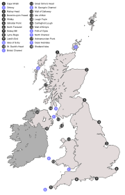
List of Inshore coastal areas
- Cape WrathCape WrathCape Wrath is a cape in Sutherland, Highland, in northern Scotland. It is the most northwesterly point on the island of Great Britain. The land between the Kyle of Durness and the lighthouse that is situated right at the tip, is known as the Parph, two hundred and seven square kilometers of...
– Rattray HeadRattray HeadRattray Head is a headland in Buchan, Aberdeenshire, on the north east coast Scotland. To north lies Strathbeg Bay and Rattray Bay is to its south...
including Orkney - Rattray Head – Berwick-upon-TweedBerwick-upon-TweedBerwick-upon-Tweed or simply Berwick is a town in the county of Northumberland and is the northernmost town in England, on the east coast at the mouth of the River Tweed. It is situated 2.5 miles south of the Scottish border....
- Berwick – WhitbyWhitbyWhitby is a seaside town, port and civil parish in the Scarborough borough of North Yorkshire, England. Situated on the east coast of Yorkshire at the mouth of the River Esk, Whitby has a combined maritime, mineral and tourist heritage, and is home to the ruins of Whitby Abbey where Caedmon, the...
- Whitby – Gibraltar PointGibraltar PointGibraltar Point National Nature Reserve is an area of approximately in Lincolnshire, England.The reserve is owned by Lincolnshire County Council and East Lindsey District Council and is administered by the Lincolnshire Wildlife Trust...
- Gibraltar Point – North ForelandNorth ForelandNorth Foreland is a chalk headland on the Kent coast of southeast England.North Foreland forms the eastern end of the Isle of Thanet. It presents a bold cliff to the sea, and commands views over the southern North Sea.-Lighthouse:...
- North Foreland – Selsey BillSelsey BillSelsey Bill is a headland into the English Channel on the south coast of England in the county of West Sussex.The southern most town in Sussex is Selsey which is at the end of the Selsey Peninsula and Selsey Bill is situated on the towns southerncoastline...
- Selsey Bill – Lyme RegisLyme RegisLyme Regis is a coastal town in West Dorset, England, situated 25 miles west of Dorchester and east of Exeter. The town lies in Lyme Bay, on the English Channel coast at the Dorset-Devon border...
- Lyme Regis – Land's EndLand's EndLand's End is a headland and small settlement in west Cornwall, England, within the United Kingdom. It is located on the Penwith peninsula approximately eight miles west-southwest of Penzance....
including the Isles of ScillyIsles of ScillyThe Isles of Scilly form an archipelago off the southwestern tip of the Cornish peninsula of Great Britain. The islands have had a unitary authority council since 1890, and are separate from the Cornwall unitary authority, but some services are combined with Cornwall and the islands are still part... - Land's End - St David's Head including the Bristol ChannelBristol ChannelThe Bristol Channel is a major inlet in the island of Great Britain, separating South Wales from Devon and Somerset in South West England. It extends from the lower estuary of the River Severn to the North Atlantic Ocean...
- St David’s Head – Great OrmeGreat OrmeThe Great Orme is a prominent limestone headland on the north coast of Wales situated in Llandudno. It is referred to as Cyngreawdr Fynydd in a poem by the 12th century poet Gwalchmai ap Meilyr...
's Head including St George's ChannelSt George's ChannelSt George's Channel is a sea channel connecting the Irish Sea to the north and the Celtic Sea to the southwest.Historically, the name "St Georges Channel" was used interchangeably with "Irish Sea" or "Irish Channel" to encompass all the waters between Ireland to the west and Great Britain to the... - Great Orme's Head – Mull of GallowayMull of GallowayThe Mull of Galloway is the southernmost point of Scotland. It is situated in Wigtownshire, Dumfries and Galloway.A lighthouse is positioned at the point . Built in 1830 by engineer Robert Stevenson, the white-painted round tower is high...
- Isle of ManIsle of ManThe Isle of Man , otherwise known simply as Mann , is a self-governing British Crown Dependency, located in the Irish Sea between the islands of Great Britain and Ireland, within the British Isles. The head of state is Queen Elizabeth II, who holds the title of Lord of Mann. The Lord of Mann is...
- Lough FoyleLough FoyleLough Foyle, sometimes Loch Foyle , is the estuary of the River Foyle in Ulster. It starts where the Foyle leaves Derry. It separates the Inishowen Peninsula in County Donegal, Republic of Ireland from County Londonderry in Northern Ireland.-Transport:...
– Carlingford LoughCarlingford LoughCarlingford Lough is a glacial fjord or sea inlet that forms part of the border between Northern Ireland to the north and the Republic of Ireland to the south. On its northern shore is County Down and on its southern shore is County Louth... - Mull of Galloway – Mull of KintyreMull of KintyreThe Mull of Kintyre is the southwesternmost tip of the Kintyre Peninsula in southwest Scotland. From here, the Antrim coast is visible and an historic lighthouse, the second commissioned in Scotland, guides shipping in the intervening North Channel...
including the Firth of ClydeFirth of ClydeThe Firth of Clyde forms a large area of coastal water, sheltered from the Atlantic Ocean by the Kintyre peninsula which encloses the outer firth in Argyll and Ayrshire, Scotland. The Kilbrannan Sound is a large arm of the Firth of Clyde, separating the Kintyre Peninsula from the Isle of Arran.At...
and the North ChannelNorth Channel (Great Britain and Ireland)The North Channel is the strait which separates eastern Northern Ireland from southwestern Scotland... - Mull of Kintyre – Ardnamurchan PointArdnamurchanArdnamurchan is a peninsula in Lochaber, Highland, Scotland, noted for being very unspoilt and undisturbed. Its remoteness is accentuated by the main access route being a single track road for much of its length.-Geography:...
- Ardnamurchan Point – Cape Wrath including the Outer HebridesOuter HebridesThe Outer Hebrides also known as the Western Isles and the Long Island, is an island chain off the west coast of Scotland. The islands are geographically contiguous with Comhairle nan Eilean Siar, one of the 32 unitary council areas of Scotland...
- Shetland Isles
The BBC's coastal forecast splits some of these into shorter lengths of coast. The points at which they are split are Duncansby Head
Duncansby Head
Duncansby Head is the most north-easterly part of the Scottish mainland, including even the famous John o' Groats, Caithness, Highland...
, Fife Ness
Fife Ness
Fife Ness is a headland , forming the most eastern point in Fife. It is situated in the area of Fife known as the East Neuk, and forms the muzzle of the dog-like outline of the latter when viewed on a map....
, Harwich
Harwich
Harwich is a town in Essex, England and one of the Haven ports, located on the coast with the North Sea to the east. It is in the Tendring district. Nearby places include Felixstowe to the northeast, Ipswich to the northwest, Colchester to the southwest and Clacton-on-Sea to the south...
, Thames Estuary
Thames Estuary
The Thames Mouth is the estuary in which the River Thames meets the waters of the North Sea.It is not easy to define the limits of the estuary, although physically the head of Sea Reach, near Canvey Island on the Essex shore is probably the western boundary...
, Beachy Head
Beachy Head
Beachy Head is a chalk headland on the south coast of England, close to the town of Eastbourne in the county of East Sussex, immediately east of the Seven Sisters. The cliff there is the highest chalk sea cliff in Britain, rising to 162 m above sea level. The peak allows views of the south...
, The Solent, St Albans Head, Start Point
Start Point, Devon
Start Point is a promontory in the South Hams district. It is one of the most southerly points in Devon, England, . It marks the southern limit of Start Bay, which extends northwards to the estuary of the River Dart....
, Hartland Point
Hartland Point
Hartland Point is a high rocky outcrop of land on the northwestern tip of the Devon coast in England. It is three miles north-west of the village of Hartland. The point marks the western limit of the Bristol Channel with the Atlantic Ocean continuing to the west...
, Holyhead
Holyhead
Holyhead is the largest town in the county of Anglesey in the North Wales. It is also a major port adjacent to the Irish Sea serving Ireland....
, Morecambe Bay
Morecambe Bay
Morecambe Bay is a large bay in northwest England, nearly due east of the Isle of Man and just to the south of the Lake District National Park. It is the largest expanse of intertidal mudflats and sand in the United Kingdom, covering a total area of 310 km².-Natural features:The rivers Leven,...
, Firth of Clyde
Firth of Clyde
The Firth of Clyde forms a large area of coastal water, sheltered from the Atlantic Ocean by the Kintyre peninsula which encloses the outer firth in Argyll and Ayrshire, Scotland. The Kilbrannan Sound is a large arm of the Firth of Clyde, separating the Kintyre Peninsula from the Isle of Arran.At...
. Additionally, there is a forecast for the Channel Islands
Channel Islands
The Channel Islands are an archipelago of British Crown Dependencies in the English Channel, off the French coast of Normandy. They include two separate bailiwicks: the Bailiwick of Guernsey and the Bailiwick of Jersey...
. See the BBC map here