

Mull of Kintyre
Encyclopedia
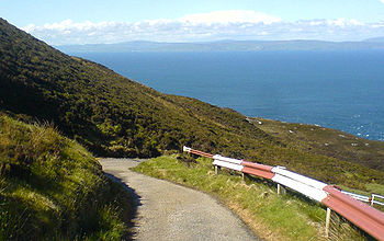
The Mull of Kintyre is the southwesternmost tip of the Kintyre Peninsula in southwest Scotland
. From here, the Antrim
coast is visible and an historic lighthouse
, the second commissioned in Scotland, guides shipping in the intervening North Channel
. The area has been immortalised in popular culture by the 1977 hit song "Mull of Kintyre
" by Kintyre resident Paul McCartney
's band of the time, Wings
.
of the Gaelic
Maol Chinn Tìre (mɯːlˠ̪ çiɲˈtʲʰiːɾʲə), or in English "The rounded [or bare] headland of Kintyre".
Mull
as a geographical term is most commonly found in southwest Scotland, where it is often applied to headlands
or promontories
, and, often more specifically, for the tip of that promontory or peninsula
.
The name "Mull" derives from , meaning a headland, signifying a jutting crag, promontory, brow of a hill or rock, and also baldness or bareness. The related derived noun refers to a land formation bare of trees, such as a rounded hill, summit, mountain or promontory.
in Argyll and Bute
, Western Scotland. It is about 8 miles beyond the southernmost village of the peninsula, Southend, and reached via a single track road.
 Ailsa Craig
and the Antrim
coast of Northern Ireland
and Rathlin Island
are all clearly visible from the Mull. On clearer days it is also possible to make out Malin Head
in County Donegal
in the Republic of Ireland
, and the Ayrshire
coast on the other side of Ailsa Craig
. Other islands in the Firth of Clyde
are also visible when looking east, especially from further back along the single track road from Southend village. The Straits of Moyle
(part of the North Channel
) allow sea passage from the Irish Sea
to the Atlantic Ocean
. Notoriously strong currents plague the tip of the Kintyre Peninsula, prohibiting swimmers and creating a hazard to unmotorised craft. At its closest point, mainland Northern Ireland is only 20 km (12.4 mi) from the Mull. Owing to the low-lying level of Rathlin Island
and the high elevation of the Mull of Kintyre it is also possible to see over the top of Rathlin Island and on towards the Antrim
coastal town of Ballycastle
, immediately behind. Visitors to the Mull may also see the individual houses of the Antrim coast and the cars travelling along the coast road without the aid of binoculars, although this is dependent on having very good visibility; the area is often being plagued with sea-mists.
The steep sides rising out of the sea on all sides have made the area a hazard to flight. The remains of a number of Second World War planes litter the area.
to Ireland
. In more recent times it was used again by the Scotti
when they travelled from Ireland to establish the kingdom of Dál Riata
in modern-day Argyll
.
The area has been the site of many air crashes throughout its history; one of the most notorious was the Chinook crash on Mull of Kintyre on 2 June 1994.
. It was designed and built by Thomas Smith
and completed in 1788. Smith had previously designed the light at Kinnaird Head
, but Mull of Kintyre was a far more substantial project, in a far more remote location.
The lighthouse was rebuilt in the 1820s. The light was fixed until 1906, when it was converted to flashing, and its power increased from 8,000 to 281,000 candela
. It was converted to electrical power in 1976, automated in 1996 and is now monitored from Edinburgh.
The former keeper's cottages are now run as holiday cottages by the National Trust for Scotland
.
, an unofficial test for the propriety of images of naked men. It is famously used by the Broadcasting Standards Commission to determine whether or not the male member may be shown on television: only penises of flaccidity similar to that of the Mull of Kintyre in relation to the mainland of Great Britain may be shown. Those in a state of greater extension are deemed to be inappropriate.
Scotland
Scotland is a country that is part of the United Kingdom. Occupying the northern third of the island of Great Britain, it shares a border with England to the south and is bounded by the North Sea to the east, the Atlantic Ocean to the north and west, and the North Channel and Irish Sea to the...
. From here, the Antrim
County Antrim
County Antrim is one of six counties that form Northern Ireland, situated in the north-east of the island of Ireland. Adjoined to the north-east shore of Lough Neagh, the county covers an area of 2,844 km², with a population of approximately 616,000...
coast is visible and an historic lighthouse
Lighthouse
A lighthouse is a tower, building, or other type of structure designed to emit light from a system of lamps and lenses or, in older times, from a fire, and used as an aid to navigation for maritime pilots at sea or on inland waterways....
, the second commissioned in Scotland, guides shipping in the intervening North Channel
North Channel (Great Britain and Ireland)
The North Channel is the strait which separates eastern Northern Ireland from southwestern Scotland...
. The area has been immortalised in popular culture by the 1977 hit song "Mull of Kintyre
Mull of Kintyre (song)
"Mull of Kintyre" is a song written by Paul McCartney and Denny Laine and performed by Wings. The song was written in tribute to the picturesque Kintyre peninsula in Scotland, where McCartney has owned High Park Farm since 1966, and its headland or Mull of Kintyre.The song was Wings' biggest hit...
" by Kintyre resident Paul McCartney
Paul McCartney
Sir James Paul McCartney, MBE, Hon RAM, FRCM is an English musician, singer-songwriter and composer. Formerly of The Beatles and Wings , McCartney is listed in Guinness World Records as the "most successful musician and composer in popular music history", with 60 gold discs and sales of 100...
's band of the time, Wings
Wings (band)
Wings were a British-American rock group formed in 1971 by Paul McCartney, Denny Laine and Linda McCartney that remained active until 1981....
.
Etymology
The name is an AnglicisationAnglicisation
Anglicisation, or anglicization , is the process of converting verbal or written elements of any other language into a form that is more comprehensible to an English speaker, or, more generally, of altering something such that it becomes English in form or character.The term most often refers to...
of the Gaelic
Goidelic languages
The Goidelic languages or Gaelic languages are one of the two branches of the Insular Celtic languages, the other consisting of the Brythonic languages. Goidelic languages historically formed a dialect continuum stretching from the south of Ireland through the Isle of Man to the north of Scotland...
Maol Chinn Tìre (mɯːlˠ̪ çiɲˈtʲʰiːɾʲə), or in English "The rounded [or bare] headland of Kintyre".
Mull
Mull (geographical term)
Mull is an Anglicization of the Gaelic Maol, a term for a rounded hill, summit, or mountain, bare of trees . As an adjective, the word is used to indicate something which is bare, dull, or bald...
as a geographical term is most commonly found in southwest Scotland, where it is often applied to headlands
Headlands and bays
Headlands and bays are two related features of the coastal environment.- Geology and geography :Headlands and bays are often found on the same coastline. A bay is surrounded by land on three sides, whereas a headland is surrounded by water on three sides. Headlands are characterized by high,...
or promontories
Promontory
Promontory may refer to:*Promontory, a prominent mass of land which overlooks lower lying land or a body of water*Promontory, Utah, the location where the United States first Transcontinental Railroad was completed...
, and, often more specifically, for the tip of that promontory or peninsula
Peninsula
A peninsula is a piece of land that is bordered by water on three sides but connected to mainland. In many Germanic and Celtic languages and also in Baltic, Slavic and Hungarian, peninsulas are called "half-islands"....
.
The name "Mull" derives from , meaning a headland, signifying a jutting crag, promontory, brow of a hill or rock, and also baldness or bareness. The related derived noun refers to a land formation bare of trees, such as a rounded hill, summit, mountain or promontory.
Geography
The Mull is at the extreme southwestern tip of the Kintyre peninsula, approximately 10 miles (16.1 km) from CampbeltownCampbeltown
Campbeltown is a town and former royal burgh in Argyll and Bute, Scotland. It lies by Campbeltown Loch on the Kintyre peninsula. Originally known as Kinlochkilkerran , it was renamed in the 17th century as Campbell's Town after Archibald Campbell was granted the site in 1667...
in Argyll and Bute
Argyll and Bute
Argyll and Bute is both one of 32 unitary council areas; and a Lieutenancy area in Scotland. The administrative centre for the council area is located in Lochgilphead.Argyll and Bute covers the second largest administrative area of any Scottish council...
, Western Scotland. It is about 8 miles beyond the southernmost village of the peninsula, Southend, and reached via a single track road.
Ailsa Craig
Ailsa Craig is an island of 219.69 acres in the outer Firth of Clyde, Scotland where blue hone granite was quarried to make curling stones. "Ailsa" is pronounced "ale-sa", with the first syllable stressed...
and the Antrim
County Antrim
County Antrim is one of six counties that form Northern Ireland, situated in the north-east of the island of Ireland. Adjoined to the north-east shore of Lough Neagh, the county covers an area of 2,844 km², with a population of approximately 616,000...
coast of Northern Ireland
Northern Ireland
Northern Ireland is one of the four countries of the United Kingdom. Situated in the north-east of the island of Ireland, it shares a border with the Republic of Ireland to the south and west...
and Rathlin Island
Rathlin Island
Rathlin Island is an island off the coast of County Antrim, and is the northernmost point of Northern Ireland. Rathlin is the only inhabited offshore island in Northern Ireland, with a rising population of now just over 100 people, and is the most northerly inhabited island off the Irish coast...
are all clearly visible from the Mull. On clearer days it is also possible to make out Malin Head
Malin Head
Malin Head , on the Inishowen Peninsula, County Donegal, is usually given as the most northerly headland of the mainland of Ireland . In fact, the most northerly point is actually a headland named Banba's Crown on the Inishowen Peninsula about 2 km to the northeast...
in County Donegal
County Donegal
County Donegal is a county in Ireland. It is part of the Border Region and is also located in the province of Ulster. It is named after the town of Donegal. Donegal County Council is the local authority for the county...
in the Republic of Ireland
Republic of Ireland
Ireland , described as the Republic of Ireland , is a sovereign state in Europe occupying approximately five-sixths of the island of the same name. Its capital is Dublin. Ireland, which had a population of 4.58 million in 2011, is a constitutional republic governed as a parliamentary democracy,...
, and the Ayrshire
Ayrshire
Ayrshire is a registration county, and former administrative county in south-west Scotland, United Kingdom, located on the shores of the Firth of Clyde. Its principal towns include Ayr, Kilmarnock and Irvine. The town of Troon on the coast has hosted the British Open Golf Championship twice in the...
coast on the other side of Ailsa Craig
Ailsa Craig
Ailsa Craig is an island of 219.69 acres in the outer Firth of Clyde, Scotland where blue hone granite was quarried to make curling stones. "Ailsa" is pronounced "ale-sa", with the first syllable stressed...
. Other islands in the Firth of Clyde
Firth of Clyde
The Firth of Clyde forms a large area of coastal water, sheltered from the Atlantic Ocean by the Kintyre peninsula which encloses the outer firth in Argyll and Ayrshire, Scotland. The Kilbrannan Sound is a large arm of the Firth of Clyde, separating the Kintyre Peninsula from the Isle of Arran.At...
are also visible when looking east, especially from further back along the single track road from Southend village. The Straits of Moyle
Straits of Moyle
The Straits of Moyle or Sea of Moyle is the name given to the narrowest expanse of sea in the North Channel between northeastern Ireland and southwestern Scotland...
(part of the North Channel
North Channel (British Isles)
The North Channel is the strait which separates eastern Northern Ireland from southwestern Scotland...
) allow sea passage from the Irish Sea
Irish Sea
The Irish Sea separates the islands of Ireland and Great Britain. It is connected to the Celtic Sea in the south by St George's Channel, and to the Atlantic Ocean in the north by the North Channel. Anglesey is the largest island within the Irish Sea, followed by the Isle of Man...
to the Atlantic Ocean
Atlantic Ocean
The Atlantic Ocean is the second-largest of the world's oceanic divisions. With a total area of about , it covers approximately 20% of the Earth's surface and about 26% of its water surface area...
. Notoriously strong currents plague the tip of the Kintyre Peninsula, prohibiting swimmers and creating a hazard to unmotorised craft. At its closest point, mainland Northern Ireland is only 20 km (12.4 mi) from the Mull. Owing to the low-lying level of Rathlin Island
Rathlin Island
Rathlin Island is an island off the coast of County Antrim, and is the northernmost point of Northern Ireland. Rathlin is the only inhabited offshore island in Northern Ireland, with a rising population of now just over 100 people, and is the most northerly inhabited island off the Irish coast...
and the high elevation of the Mull of Kintyre it is also possible to see over the top of Rathlin Island and on towards the Antrim
County Antrim
County Antrim is one of six counties that form Northern Ireland, situated in the north-east of the island of Ireland. Adjoined to the north-east shore of Lough Neagh, the county covers an area of 2,844 km², with a population of approximately 616,000...
coastal town of Ballycastle
Ballycastle
Ballycastle can refer to:*Ballycastle, County Antrim, a small town in Northern Ireland*Ballycastle, County Mayo, a village in the Republic of Ireland...
, immediately behind. Visitors to the Mull may also see the individual houses of the Antrim coast and the cars travelling along the coast road without the aid of binoculars, although this is dependent on having very good visibility; the area is often being plagued with sea-mists.
The steep sides rising out of the sea on all sides have made the area a hazard to flight. The remains of a number of Second World War planes litter the area.
History
The Mull has been an important landbridge throughout history. It is thought that it was used by early humans in their travels from continental EuropeContinental Europe
Continental Europe, also referred to as mainland Europe or simply the Continent, is the continent of Europe, explicitly excluding European islands....
to Ireland
Ireland
Ireland is an island to the northwest of continental Europe. It is the third-largest island in Europe and the twentieth-largest island on Earth...
. In more recent times it was used again by the Scotti
Scoti
Scoti or Scotti was the generic name used by the Romans to describe those who sailed from Ireland to conduct raids on Roman Britain. It was thus synonymous with the modern term Gaels...
when they travelled from Ireland to establish the kingdom of Dál Riata
Dál Riata
Dál Riata was a Gaelic overkingdom on the western coast of Scotland with some territory on the northeast coast of Ireland...
in modern-day Argyll
Argyll
Argyll , archaically Argyle , is a region of western Scotland corresponding with most of the part of ancient Dál Riata that was located on the island of Great Britain, and in a historical context can be used to mean the entire western coast between the Mull of Kintyre and Cape Wrath...
.
The area has been the site of many air crashes throughout its history; one of the most notorious was the Chinook crash on Mull of Kintyre on 2 June 1994.
Lighthouse
The Mull of Kintyre Lighthouse was the second lighthouse commissioned in Scotland by the Commissioners of the Northern LightsNorthern Lighthouse Board
The Northern Lighthouse Board is the General Lighthouse Authority for Scotland and the Isle of Man. It is a non-departmental public body responsible for marine navigation aids around coastal areas.-History:...
. It was designed and built by Thomas Smith
Thomas Smith (engineer)
Thomas Smith was a Scottish businessman and early lighthouse engineer. Born in Broughty Ferry, Dundee, his father drowned in Dundee harbour when he was young...
and completed in 1788. Smith had previously designed the light at Kinnaird Head
Kinnaird Head
Kinnaird Head is a headland projecting into the North Sea, within the town of Fraserburgh, Aberdeenshire on the east coast of Scotland. It is the site of the first lighthouse in Scotland to be lit by the Commissioners of Northern Lights...
, but Mull of Kintyre was a far more substantial project, in a far more remote location.
The lighthouse was rebuilt in the 1820s. The light was fixed until 1906, when it was converted to flashing, and its power increased from 8,000 to 281,000 candela
Candela
The candela is the SI base unit of luminous intensity; that is, power emitted by a light source in a particular direction, weighted by the luminosity function . A common candle emits light with a luminous intensity of roughly one candela...
. It was converted to electrical power in 1976, automated in 1996 and is now monitored from Edinburgh.
The former keeper's cottages are now run as holiday cottages by the National Trust for Scotland
National Trust for Scotland
The National Trust for Scotland for Places of Historic Interest or Natural Beauty, commonly known as the National Trust for Scotland describes itself as the conservation charity that protects and promotes Scotland's natural and cultural heritage for present and future generations to...
.
Trivia
The Mull of Kintyre is used as a reference in the Mull of Kintyre testMull of Kintyre test
The Mull of Kintyre Rule was an unofficial guideline said to have been used by the British Board of Film Classification in the United Kingdom to decide whether an image of a man's penis could be shown....
, an unofficial test for the propriety of images of naked men. It is famously used by the Broadcasting Standards Commission to determine whether or not the male member may be shown on television: only penises of flaccidity similar to that of the Mull of Kintyre in relation to the mainland of Great Britain may be shown. Those in a state of greater extension are deemed to be inappropriate.