
1886 Atlantic hurricane season
Encyclopedia
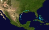
The 1886 Atlantic hurricane season ran through the summer and the first half of fall in 1886.
, 1936
, 1909
and this), this was the only season to have three June hurricanes.
/Louisiana
border.
.
and into the Gulf of Mexico
on August 18 heading northwest toward the Texas coast. The hurricane caused catastrophic damage in Indianola, Texas
on August 20, and also caused at least 25 deaths. While the hurricane made landfall as a strong Category 4 hurricane, it is possible it was a Category 5 hurricane over water, having made landfall with winds of 150 mi/h.
as a hurricane, and passed through the Caribbean Sea. It hit Jamaica
with winds of 110 mi/h, and later made landfall on Cuba
as a major hurricane. It moved northeastward, and dissipated south of Newfoundland on the 27th.
between Brownsville
and Corpus Christi
as a 100 mi/h hurricane on September 23.
on October 8. It moved to the northwest, reaching major hurricane strength in the Gulf of Mexico
on the 11th. Late on the 12th, the hurricane made landfall near the border between Louisiana
and Texas
. It caused 175-200 deaths due to the heavy rainfall and storm surge, with $250,000 in damage occurring.
before moving out to sea. Peak winds of 70 mph (110 km/h).
Storms
The 1886 Atlantic hurricane season began with 3 U.S. landfalling hurricanes in June. Of the four years that have had three June tropical storms (19681968 Atlantic hurricane season
The 1968 Atlantic hurricane season officially began on June 1, 1968, and lasted until November 30, 1968. These dates conventionally delimit the period of each year when most tropical cyclones form in the Atlantic basin....
, 1936
1936 Atlantic hurricane season
The 1936 Atlantic hurricane season officially began on June 16, 1936, and lasted until October 31, 1936. These dates conventionally delimit the period of each year when most tropical cyclones form in the Atlantic basin....
, 1909
1909 Atlantic hurricane season
The 1909 Atlantic hurricane season was an average Atlantic hurricane season, officially starting on June 1, 1909, and ending on November 30, 1909, dates which conventionally delimit the period of each year when tropical cyclones tend to form in the Atlantic basin...
and this), this was the only season to have three June hurricanes.
Hurricane One
Max winds of 100 mi/h, minimum pressure of 997 mbar. The hurricane made landfall near the TexasTexas
Texas is the second largest U.S. state by both area and population, and the largest state by area in the contiguous United States.The name, based on the Caddo word "Tejas" meaning "friends" or "allies", was applied by the Spanish to the Caddo themselves and to the region of their settlement in...
/Louisiana
Louisiana
Louisiana is a state located in the southern region of the United States of America. Its capital is Baton Rouge and largest city is New Orleans. Louisiana is the only state in the U.S. with political subdivisions termed parishes, which are local governments equivalent to counties...
border.
Hurricane Two
Max winds of 100 mi/h, made landfall in the Florida PanhandleFlorida Panhandle
The Florida Panhandle, an informal, unofficial term for the northwestern part of Florida, is a strip of land roughly 200 miles long and 50 to 100 miles wide , lying between Alabama on the north and the west, Georgia also on the north, and the Gulf of Mexico to the south. Its eastern boundary is...
.
Hurricane Three
Max winds of 100 mi/h, also made landfall in the Florida PanhandleFlorida Panhandle
The Florida Panhandle, an informal, unofficial term for the northwestern part of Florida, is a strip of land roughly 200 miles long and 50 to 100 miles wide , lying between Alabama on the north and the west, Georgia also on the north, and the Gulf of Mexico to the south. Its eastern boundary is...
Hurricane Four
The 4th storm of the year developed in the western Caribbean on July 14. It moved northward, reaching hurricane strength before hitting Florida on the 18th. It reached a peak of 85 mi/h over the Western Atlantic while moving out to sea, and became extratropical on July 22.Hurricane Five
The 5th storm of the season passed south of Key WestKey West
Key West is an island in the Straits of Florida on the North American continent at the southernmost tip of the Florida Keys. Key West is home to the southernmost point in the Continental United States; the island is about from Cuba....
and into the Gulf of Mexico
Gulf of Mexico
The Gulf of Mexico is a partially landlocked ocean basin largely surrounded by the North American continent and the island of Cuba. It is bounded on the northeast, north and northwest by the Gulf Coast of the United States, on the southwest and south by Mexico, and on the southeast by Cuba. In...
on August 18 heading northwest toward the Texas coast. The hurricane caused catastrophic damage in Indianola, Texas
Indianola, Texas
Indianola is a ghost town located on Matagorda Bay in Calhoun County, Texas, United States. The community, once the county seat of Calhoun County, is a part of the Victoria, Texas, Metropolitan Statistical Area. In 1875, the city had a population of 5,000, but on September 15 of that year, a...
on August 20, and also caused at least 25 deaths. While the hurricane made landfall as a strong Category 4 hurricane, it is possible it was a Category 5 hurricane over water, having made landfall with winds of 150 mi/h.
Hurricane Six
The 6th storm of the season, which formed on August 15, moved through the Lesser AntillesLesser Antilles
The Lesser Antilles are a long, partly volcanic island arc in the Western Hemisphere. Most of its islands form the eastern boundary of the Caribbean Sea with the Atlantic Ocean, with the remainder located in the southern Caribbean just north of South America...
as a hurricane, and passed through the Caribbean Sea. It hit Jamaica
Jamaica
Jamaica is an island nation of the Greater Antilles, in length, up to in width and 10,990 square kilometres in area. It is situated in the Caribbean Sea, about south of Cuba, and west of Hispaniola, the island harbouring the nation-states Haiti and the Dominican Republic...
with winds of 110 mi/h, and later made landfall on Cuba
Cuba
The Republic of Cuba is an island nation in the Caribbean. The nation of Cuba consists of the main island of Cuba, the Isla de la Juventud, and several archipelagos. Havana is the largest city in Cuba and the country's capital. Santiago de Cuba is the second largest city...
as a major hurricane. It moved northeastward, and dissipated south of Newfoundland on the 27th.
Hurricane Seven
The 7th storm was a major hurricane that, after weakening, moved through the Canadian maritimes.Hurricane Eight
The 8th storm of the season took a west track through Cuba and the Gulf of Mexico. It turned northward in the western gulf, and made landfall in TexasTexas
Texas is the second largest U.S. state by both area and population, and the largest state by area in the contiguous United States.The name, based on the Caddo word "Tejas" meaning "friends" or "allies", was applied by the Spanish to the Caddo themselves and to the region of their settlement in...
between Brownsville
Brownsville, Texas
Brownsville is a city in the southernmost tip of the state of Texas, in the United States. It is located on the northern bank of the Rio Grande, directly north and across the border from Matamoros, Tamaulipas, Mexico. Brownsville is the 16th largest city in the state of Texas with a population of...
and Corpus Christi
Corpus Christi, Texas
Corpus Christi is a coastal city in the South Texas region of the U.S. state of Texas. The county seat of Nueces County, it also extends into Aransas, Kleberg, and San Patricio counties. The MSA population in 2008 was 416,376. The population was 305,215 at the 2010 census making it the...
as a 100 mi/h hurricane on September 23.
Hurricane Nine
The 9th storm existed for 8 days in late September over the open waters of the Central Atlantic.Hurricane Ten
A tropical storm was observed in the northwest Caribbean SeaCaribbean Sea
The Caribbean Sea is a sea of the Atlantic Ocean located in the tropics of the Western hemisphere. It is bounded by Mexico and Central America to the west and southwest, to the north by the Greater Antilles, and to the east by the Lesser Antilles....
on October 8. It moved to the northwest, reaching major hurricane strength in the Gulf of Mexico
Gulf of Mexico
The Gulf of Mexico is a partially landlocked ocean basin largely surrounded by the North American continent and the island of Cuba. It is bounded on the northeast, north and northwest by the Gulf Coast of the United States, on the southwest and south by Mexico, and on the southeast by Cuba. In...
on the 11th. Late on the 12th, the hurricane made landfall near the border between Louisiana
Louisiana
Louisiana is a state located in the southern region of the United States of America. Its capital is Baton Rouge and largest city is New Orleans. Louisiana is the only state in the U.S. with political subdivisions termed parishes, which are local governments equivalent to counties...
and Texas
Texas
Texas is the second largest U.S. state by both area and population, and the largest state by area in the contiguous United States.The name, based on the Caddo word "Tejas" meaning "friends" or "allies", was applied by the Spanish to the Caddo themselves and to the region of their settlement in...
. It caused 175-200 deaths due to the heavy rainfall and storm surge, with $250,000 in damage occurring.
Tropical Storm Eleven
The 11th storm of the 1886 season was the weakest storm of the year, peaking at only 50 mi/h.Tropical Storm Twelve
The 12th and final storm crossed HaitiHaiti
Haiti , officially the Republic of Haiti , is a Caribbean country. It occupies the western, smaller portion of the island of Hispaniola, in the Greater Antillean archipelago, which it shares with the Dominican Republic. Ayiti was the indigenous Taíno or Amerindian name for the island...
before moving out to sea. Peak winds of 70 mph (110 km/h).
See also
- List of Atlantic hurricanes
- List of Atlantic hurricane seasons