
.gif)
Hurricane Dora (1999)
Encyclopedia
Hurricane Dora was the longest-lasting tropical cyclone
of the 1999 Pacific hurricane season
. The fourth named storm, third hurricane, and second major hurricane of the season, Dora developed on August 6 from a tropical wave
to the south of Mexico. It maintained a steady westward track for much of its lifetime, reaching peak winds of 140 mph (220 km/h) on August 12 and August 13. Dora lasted for a total of 17 days before dissipating on August 23 to the north of Wake Island
in the western Pacific Ocean.
Although it never made landfall, Dora produced high surf, gale force winds and light rain across southeastern Hawaii
and Johnston Island. There were no reported deaths or injuries from the hurricane.
that moved off the coast of Africa on July 23. The system moved across the Atlantic Ocean without development, and on August 4 it crossed Central America into the eastern Pacific Ocean with some disorganized convection. A low-level circulation developed the next day as banding features
increased, and early on August 6 it became Tropical Depression Four-E while located about 335 miles (540 km) south of Acapulco
. Despite some initial vertical wind shear
, the depression steadily intensified, and received the name Dora by the National Hurricane Center
after attaining tropical storm status late on August 6.
Moving westward along a decaying subtropical ridge
, Dora steadily increased to hurricane status on August 8, based on estimates through the Dvořák technique
. Weak wind shear
ahead of the storm and warm waters allowed continued strengthening as a small, well-defined eye
formed. On August 12, Dora reached its peak intensity of 140 mph (220 km/h) as the barometric pressure dropped to a minimum of 943 mbar
. Shortly after its peak intensity, Dora underwent an eyewall replacement cycle, resulting in a brief weakening before again restrengthening to winds of 140 mph (220 km/h) late on August 13. Dora never strengthened any further as the storm encountered cooler waters and light wind shear
.
Subsequent to peaking in intensity, Dora encountered cooler waters and increased wind shear. On August 14 it crossed into the central Pacific Ocean as a Category 2 hurricane on the Saffir-Simpson Hurricane Scale
; the duty of hurricane warnings were transferred from the National Hurricane Center to the Central Pacific Hurricane Center
. Dora again encountered favorable conditions, and on August 15 re-intensified to major hurricane
status as it passed 200 miles (320 km) south of Big Island, Hawaii
. The secondary peak intensity was brief, as weakening occurred after the forward speed increased. Dora passed 65 miles (105 km) south of Johnston Island on August 18 before turning west-northwest, and on August 19 it crossed the International Date Line
as a 70 mph (115 km/h) tropical storm; the Joint Typhoon Warning Center
tracked the remainder of the duration of Dora. The storm encountered stronger wind shear, and by August 21 winds decreased to below tropical storm force. On August 23, the circulation became exposed from the main convection, and at 1800 UTC Tropical Depression Dora dissipated about 450 miles (725 km) northeast of Wake Island
.
 On August 16, forecast models predicted Dora would bypass Johnston Island a short distance to the south, with some concerns of a direct hit on the island. As a result of the threat, about 1,200 workers and residents evacuated Johnston Atoll
to Hawaii
. Prior to leaving, workers secured construction equipment and other loose items. Some biologist
s on Johnston Atoll
were concerned that the hurricane would severely impact the reproductive cycle of over 150,000 birds in the Johnston Atoll Wildlife Refuge, a concern expressed after Hurricane John
in 1994 killed 80% of the bird population during its impact on Johnston Atoll
. Additionally, the Central Pacific Hurricane Center predicted Dora would strike Wake Island
as a minimal typhoon, though it did not occur.
An ocean swell from Dora produced 8 – 20 foot (2 – 6 m) waves along the east and southern shores of the island of Hawaii
. This prompted local officials to close all beaches, campsites and nature trails in the Puna
and Kau
districts due to the deteriorating conditions. The outer rainbands produced produced winds of up to 60 mph (95 km/h) at some high elevations, and also resulted in some light rainfall. Hurricane Dora also produced rough surf on Johnston Island, with one forecaster remarking the surf was the most severe aspect of the storm. The automatic station at Johnston Atoll reported wind gusts between 40 — 45 mph (75 – 85 km/h) for two hours. Overall effects were minimal, and there were no reports of damage or injuries.
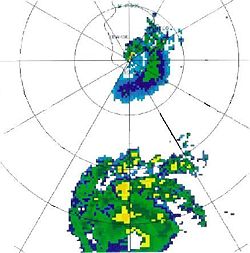
With a total track of 6,500 miles (10,500 km), Hurricane Dora had the second longest track of a Pacific hurricane
, behind only Hurricane John
of 1994; the length of the track of Dora was more than four times the basin average. Dora was also the first Pacific hurricane
to come close enough to be detected by radar
. In addition, the hurricane was the first tropical cyclone to move across all three Pacific basins since John in 1994.
Tropical cyclone
A tropical cyclone is a storm system characterized by a large low-pressure center and numerous thunderstorms that produce strong winds and heavy rain. Tropical cyclones strengthen when water evaporated from the ocean is released as the saturated air rises, resulting in condensation of water vapor...
of the 1999 Pacific hurricane season
1999 Pacific hurricane season
The 1999 Pacific hurricane season officially started on May 15, 1999 in the eastern Pacific, and on June 1, 1999 in the central Pacific, and lasted until November 30, 1999. These dates conventionally delimit the period of each year when most tropical cyclones form in the northeastern Pacific...
. The fourth named storm, third hurricane, and second major hurricane of the season, Dora developed on August 6 from a tropical wave
Tropical wave
Tropical waves, easterly waves, or tropical easterly waves, also known as African easterly waves in the Atlantic region, are a type of atmospheric trough, an elongated area of relatively low air pressure, oriented north to south, which move from east to west across the tropics causing areas of...
to the south of Mexico. It maintained a steady westward track for much of its lifetime, reaching peak winds of 140 mph (220 km/h) on August 12 and August 13. Dora lasted for a total of 17 days before dissipating on August 23 to the north of Wake Island
Wake Island
Wake Island is a coral atoll having a coastline of in the North Pacific Ocean, located about two-thirds of the way from Honolulu west to Guam east. It is an unorganized, unincorporated territory of the United States, administered by the Office of Insular Affairs, U.S. Department of the Interior...
in the western Pacific Ocean.
Although it never made landfall, Dora produced high surf, gale force winds and light rain across southeastern Hawaii
Hawaii
Hawaii is the newest of the 50 U.S. states , and is the only U.S. state made up entirely of islands. It is the northernmost island group in Polynesia, occupying most of an archipelago in the central Pacific Ocean, southwest of the continental United States, southeast of Japan, and northeast of...
and Johnston Island. There were no reported deaths or injuries from the hurricane.
Meteorological history
The precursor of Dora was a tropical waveTropical wave
Tropical waves, easterly waves, or tropical easterly waves, also known as African easterly waves in the Atlantic region, are a type of atmospheric trough, an elongated area of relatively low air pressure, oriented north to south, which move from east to west across the tropics causing areas of...
that moved off the coast of Africa on July 23. The system moved across the Atlantic Ocean without development, and on August 4 it crossed Central America into the eastern Pacific Ocean with some disorganized convection. A low-level circulation developed the next day as banding features
Squall
A squall is a sudden, sharp increase in wind speed which is usually associated with active weather, such as rain showers, thunderstorms, or heavy snow. Squalls refer to an increase in the sustained winds over a short time interval, as there may be higher gusts during a squall event...
increased, and early on August 6 it became Tropical Depression Four-E while located about 335 miles (540 km) south of Acapulco
Acapulco
Acapulco is a city, municipality and major sea port in the state of Guerrero on the Pacific coast of Mexico, southwest from Mexico City. Acapulco is located on a deep, semi-circular bay and has been a port since the early colonial period of Mexico’s history...
. Despite some initial vertical wind shear
Wind shear
Wind shear, sometimes referred to as windshear or wind gradient, is a difference in wind speed and direction over a relatively short distance in the atmosphere...
, the depression steadily intensified, and received the name Dora by the National Hurricane Center
National Hurricane Center
The National Hurricane Center , located at Florida International University in Miami, Florida, is the division of the National Weather Service responsible for tracking and predicting weather systems within the tropics between the Prime Meridian and the 140th meridian west poleward to the 30th...
after attaining tropical storm status late on August 6.
Moving westward along a decaying subtropical ridge
Subtropical ridge
The subtropical ridge is a significant belt of high pressure situated around the latitudes of 30°N in the Northern Hemisphere and 30°S in the Southern Hemisphere. It is characterized by mostly calm winds, which acts to reduce air quality under its axis by causing fog overnight, and haze during...
, Dora steadily increased to hurricane status on August 8, based on estimates through the Dvořák technique
Dvorak technique
The Dvorak technique is a widely used system to subjectively estimate tropical cyclone intensity based solely on visible and infrared satellite images. Several agencies issue Dvorak intensity numbers for cyclones of sufficient intensity...
. Weak wind shear
Wind shear
Wind shear, sometimes referred to as windshear or wind gradient, is a difference in wind speed and direction over a relatively short distance in the atmosphere...
ahead of the storm and warm waters allowed continued strengthening as a small, well-defined eye
Eye (cyclone)
The eye is a region of mostly calm weather found at the center of strong tropical cyclones. The eye of a storm is a roughly circular area and typically 30–65 km in diameter. It is surrounded by the eyewall, a ring of towering thunderstorms where the second most severe weather of a cyclone...
formed. On August 12, Dora reached its peak intensity of 140 mph (220 km/h) as the barometric pressure dropped to a minimum of 943 mbar
Bar (unit)
The bar is a unit of pressure equal to 100 kilopascals, and roughly equal to the atmospheric pressure on Earth at sea level. Other units derived from the bar are the megabar , kilobar , decibar , centibar , and millibar...
. Shortly after its peak intensity, Dora underwent an eyewall replacement cycle, resulting in a brief weakening before again restrengthening to winds of 140 mph (220 km/h) late on August 13. Dora never strengthened any further as the storm encountered cooler waters and light wind shear
Wind shear
Wind shear, sometimes referred to as windshear or wind gradient, is a difference in wind speed and direction over a relatively short distance in the atmosphere...
.
Subsequent to peaking in intensity, Dora encountered cooler waters and increased wind shear. On August 14 it crossed into the central Pacific Ocean as a Category 2 hurricane on the Saffir-Simpson Hurricane Scale
Saffir-Simpson Hurricane Scale
The Saffir–Simpson Hurricane Scale , or the Saffir–Simpson Hurricane Wind Scale , classifies hurricanes — Western Hemisphere tropical cyclones that exceed the intensities of tropical depressions and tropical storms — into five categories distinguished by the intensities of their sustained winds...
; the duty of hurricane warnings were transferred from the National Hurricane Center to the Central Pacific Hurricane Center
Central Pacific Hurricane Center
The Central Pacific Hurricane Center of the United States National Weather Service is the official body responsible for tracking and issuing tropical cyclone warnings, watches, advisories, discussions, and statements for the Central North Pacific Basin...
. Dora again encountered favorable conditions, and on August 15 re-intensified to major hurricane
Tropical cyclone scales
Tropical systems are officially ranked on one of several tropical cyclone scales according to their maximum sustained winds and in what oceanic basin they are located...
status as it passed 200 miles (320 km) south of Big Island, Hawaii
Hawaii
Hawaii is the newest of the 50 U.S. states , and is the only U.S. state made up entirely of islands. It is the northernmost island group in Polynesia, occupying most of an archipelago in the central Pacific Ocean, southwest of the continental United States, southeast of Japan, and northeast of...
. The secondary peak intensity was brief, as weakening occurred after the forward speed increased. Dora passed 65 miles (105 km) south of Johnston Island on August 18 before turning west-northwest, and on August 19 it crossed the International Date Line
International Date Line
The International Date Line is a generally north-south imaginary line on the surface of the Earth, passing through the middle of the Pacific Ocean, that designates the place where each calendar day begins...
as a 70 mph (115 km/h) tropical storm; the Joint Typhoon Warning Center
Joint Typhoon Warning Center
The Joint Typhoon Warning Center is a joint United States Navy – United States Air Force task force located at the Naval Maritime Forecast Center in Pearl Harbor, Hawaii...
tracked the remainder of the duration of Dora. The storm encountered stronger wind shear, and by August 21 winds decreased to below tropical storm force. On August 23, the circulation became exposed from the main convection, and at 1800 UTC Tropical Depression Dora dissipated about 450 miles (725 km) northeast of Wake Island
Wake Island
Wake Island is a coral atoll having a coastline of in the North Pacific Ocean, located about two-thirds of the way from Honolulu west to Guam east. It is an unorganized, unincorporated territory of the United States, administered by the Office of Insular Affairs, U.S. Department of the Interior...
.
Impact and records
Johnston Atoll
Johnston Atoll is a atoll in the North Pacific Ocean about west of Hawaii. There are four islands located on the coral reef platform, two natural islands, Johnston Island and Sand Island, which have been expanded by coral dredging, as well as North Island and East Island , an additional two...
to Hawaii
Hawaii
Hawaii is the newest of the 50 U.S. states , and is the only U.S. state made up entirely of islands. It is the northernmost island group in Polynesia, occupying most of an archipelago in the central Pacific Ocean, southwest of the continental United States, southeast of Japan, and northeast of...
. Prior to leaving, workers secured construction equipment and other loose items. Some biologist
Biologist
A biologist is a scientist devoted to and producing results in biology through the study of life. Typically biologists study organisms and their relationship to their environment. Biologists involved in basic research attempt to discover underlying mechanisms that govern how organisms work...
s on Johnston Atoll
Johnston Atoll
Johnston Atoll is a atoll in the North Pacific Ocean about west of Hawaii. There are four islands located on the coral reef platform, two natural islands, Johnston Island and Sand Island, which have been expanded by coral dredging, as well as North Island and East Island , an additional two...
were concerned that the hurricane would severely impact the reproductive cycle of over 150,000 birds in the Johnston Atoll Wildlife Refuge, a concern expressed after Hurricane John
Hurricane John (1994)
Hurricane John formed during the 1994 Pacific hurricane season and became both the longest-lasting and the farthest-traveling tropical cyclone ever observed...
in 1994 killed 80% of the bird population during its impact on Johnston Atoll
Johnston Atoll
Johnston Atoll is a atoll in the North Pacific Ocean about west of Hawaii. There are four islands located on the coral reef platform, two natural islands, Johnston Island and Sand Island, which have been expanded by coral dredging, as well as North Island and East Island , an additional two...
. Additionally, the Central Pacific Hurricane Center predicted Dora would strike Wake Island
Wake Island
Wake Island is a coral atoll having a coastline of in the North Pacific Ocean, located about two-thirds of the way from Honolulu west to Guam east. It is an unorganized, unincorporated territory of the United States, administered by the Office of Insular Affairs, U.S. Department of the Interior...
as a minimal typhoon, though it did not occur.
An ocean swell from Dora produced 8 – 20 foot (2 – 6 m) waves along the east and southern shores of the island of Hawaii
Hawaii (island)
The Island of Hawaii, also called the Big Island or Hawaii Island , is a volcanic island in the North Pacific Ocean...
. This prompted local officials to close all beaches, campsites and nature trails in the Puna
Puna, Hawaii
Puna is one of the nine districts in Hawaii County, Big Island, Hawaii. The District of Puna is located on the easternmost portion of the island and shares borders to the north with the District of South Hilo and a border to the west with the District of Kaū...
and Kau
Kau, Hawaii
thumb|right|300px|The districts of the [[Hawaii |Big Island]]. From Northernmost, clockwise; [[Kohala, Hawaii|Kohala]], [[Hamakua]], [[Hilo, Hawaii|Hilo]], [[Puna, Hawaii|Puna]], Kau , [[Kona District, Hawaii|Kona]]...
districts due to the deteriorating conditions. The outer rainbands produced produced winds of up to 60 mph (95 km/h) at some high elevations, and also resulted in some light rainfall. Hurricane Dora also produced rough surf on Johnston Island, with one forecaster remarking the surf was the most severe aspect of the storm. The automatic station at Johnston Atoll reported wind gusts between 40 — 45 mph (75 – 85 km/h) for two hours. Overall effects were minimal, and there were no reports of damage or injuries.
With a total track of 6,500 miles (10,500 km), Hurricane Dora had the second longest track of a Pacific hurricane
Pacific hurricane
A Pacific hurricane or tropical storm is a tropical cyclone that develops in the northeastern part of the Pacific Ocean. For organizational purposes, the northern Pacific Ocean is divided into three regions: the eastern, , central , and western...
, behind only Hurricane John
Hurricane John (1994)
Hurricane John formed during the 1994 Pacific hurricane season and became both the longest-lasting and the farthest-traveling tropical cyclone ever observed...
of 1994; the length of the track of Dora was more than four times the basin average. Dora was also the first Pacific hurricane
Pacific hurricane
A Pacific hurricane or tropical storm is a tropical cyclone that develops in the northeastern part of the Pacific Ocean. For organizational purposes, the northern Pacific Ocean is divided into three regions: the eastern, , central , and western...
to come close enough to be detected by radar
Radar
Radar is an object-detection system which uses radio waves to determine the range, altitude, direction, or speed of objects. It can be used to detect aircraft, ships, spacecraft, guided missiles, motor vehicles, weather formations, and terrain. The radar dish or antenna transmits pulses of radio...
. In addition, the hurricane was the first tropical cyclone to move across all three Pacific basins since John in 1994.
See also
- List of Pacific hurricanes
- Other storms with the same name