

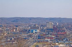
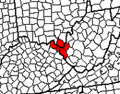
Huntington-Ashland, WV-KY-OH, Metropolitan Statistical Area
Encyclopedia
The Huntington
-Ashland
-Ironton
metropolitan area is a United States metropolitan area that includes five counties in West Virginia
, Kentucky
and Ohio
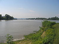
. As of the 2000 census, the MSA had a population of 288,649. A July 1, 2009 estimate placed the population at 285,624. The MSA is nestled along the banks of the Ohio River
within the Appalachian Plateau
region. The area is most often referred to locally as the Tri-State region. Sometimes it is also referred to as the KYOVA area, an acronym that refers to the three states that make up the region. In addition, the three largest cities (Huntington, West Virginia
; Ashland, Kentucky
and Ironton, Ohio
) are referred to locally as the River Cities.

 As of the census of 2000, there were 288,649 people, 117,697 households, and 81,089 families residing within the MSA. The racial makeup of the MSA was 95.91% White, 2.42% African American, 0.18% Native American, 0.43% Asian, 0.02% Pacific Islander, 0.15% from other races
, and 0.89% from two or more races. Hispanic or Latino of any race were 0.68% of the population.
The median income for a household in the MSA was $29,970, and the median income for a family was $37,102. Males had a median income of $33,032 versus $21,543 for females. The per capita income for the MSA was $16,514.
In 2008, an Associated Press article designated the Huntington-Ashland metropolitan area as the unhealthiest in America, based on its analysis of data collected in 2006 by the Centers for Disease Control and Prevention. Nearly half the adults in this metropolitan area were obese.http://www.herald-dispatch.com/news/briefs/x2114471550/Huntington-area-labeled-as-nation-s-most-unhealthy
Huntington, West Virginia
Huntington is a city in Cabell and Wayne counties in the U.S. state of West Virginia, along the Ohio River. Most of the city is in Cabell County, for which it is the county seat. A small portion of the city, mainly the neighborhood of Westmoreland, is in Wayne County. Its population was 49,138 at...
-Ashland
Ashland, Kentucky
Ashland, formerly known as Poage Settlement, is a city in Boyd County, Kentucky, United States, nestled along the banks of the Ohio River. The population was 21,981 at the 2000 census. Ashland is a part of the Huntington-Ashland, WV-KY-OH, Metropolitan Statistical Area . As of the 2000 census, the...
-Ironton
Ironton, Ohio
Ironton is a city in the U.S. state of Ohio and the county seat of Lawrence County. The municipality is located in southern Ohio along the Ohio River. The population was 11,211 at the 2000 census. Ironton is a part of the Huntington-Ashland, WV-KY-OH, Metropolitan Statistical Area . As of the...
metropolitan area is a United States metropolitan area that includes five counties in West Virginia
West Virginia
West Virginia is a state in the Appalachian and Southeastern regions of the United States, bordered by Virginia to the southeast, Kentucky to the southwest, Ohio to the northwest, Pennsylvania to the northeast and Maryland to the east...
, Kentucky
Kentucky
The Commonwealth of Kentucky is a state located in the East Central United States of America. As classified by the United States Census Bureau, Kentucky is a Southern state, more specifically in the East South Central region. Kentucky is one of four U.S. states constituted as a commonwealth...
and Ohio
Ohio
Ohio is a Midwestern state in the United States. The 34th largest state by area in the U.S.,it is the 7th‑most populous with over 11.5 million residents, containing several major American cities and seven metropolitan areas with populations of 500,000 or more.The state's capital is Columbus...
. As of the 2000 census, the MSA had a population of 288,649. A July 1, 2009 estimate placed the population at 285,624. The MSA is nestled along the banks of the Ohio River
Ohio River
The Ohio River is the largest tributary, by volume, of the Mississippi River. At the confluence, the Ohio is even bigger than the Mississippi and, thus, is hydrologically the main stream of the whole river system, including the Allegheny River further upstream...
within the Appalachian Plateau
Appalachian Plateau
The Appalachian Plateau is the western part of the Appalachian mountains, stretching from New York and Alabama. The plateau is a second level United States physiographic region....
region. The area is most often referred to locally as the Tri-State region. Sometimes it is also referred to as the KYOVA area, an acronym that refers to the three states that make up the region. In addition, the three largest cities (Huntington, West Virginia
Huntington, West Virginia
Huntington is a city in Cabell and Wayne counties in the U.S. state of West Virginia, along the Ohio River. Most of the city is in Cabell County, for which it is the county seat. A small portion of the city, mainly the neighborhood of Westmoreland, is in Wayne County. Its population was 49,138 at...
; Ashland, Kentucky
Ashland, Kentucky
Ashland, formerly known as Poage Settlement, is a city in Boyd County, Kentucky, United States, nestled along the banks of the Ohio River. The population was 21,981 at the 2000 census. Ashland is a part of the Huntington-Ashland, WV-KY-OH, Metropolitan Statistical Area . As of the 2000 census, the...
and Ironton, Ohio
Ironton, Ohio
Ironton is a city in the U.S. state of Ohio and the county seat of Lawrence County. The municipality is located in southern Ohio along the Ohio River. The population was 11,211 at the 2000 census. Ironton is a part of the Huntington-Ashland, WV-KY-OH, Metropolitan Statistical Area . As of the...
) are referred to locally as the River Cities.
Counties
In alphabetical order:| County | State | Population | Seat County seat A county seat is an administrative center, or seat of government, for a county or civil parish. The term is primarily used in the United States.... |
|---|---|---|---|
| Boyd Boyd County, Kentucky Boyd County is a county located in the U.S. state of Kentucky. It was formed in 1860. Its are found at the northeastern edge of the state the near the Ohio River and Big Sandy River, nestled in the verdant rolling hills of Appalachia. The county seat is Catlettsburg. Its largest municipality is... |
Kentucky | 49,752 | Catlettsburg Catlettsburg, Kentucky Catlettsburg is a city in Boyd County, Kentucky, United States and is the county seat of Boyd County. The city population was 1,960 at the 2000 census. The city's postal ZIP code serves a greater population of 10,029, which is a better reflection of the community's size. Catlettsburg is a part of... |
| Cabell Cabell County, West Virginia As of the census of 2000, there were 96,784 people, 41,180 households, and 25,490 families residing in the county. The population density was 344 people per square mile . There were 45,615 housing units at an average density of 162 per square mile... |
West Virginia | 96,784 | Huntington Huntington, West Virginia Huntington is a city in Cabell and Wayne counties in the U.S. state of West Virginia, along the Ohio River. Most of the city is in Cabell County, for which it is the county seat. A small portion of the city, mainly the neighborhood of Westmoreland, is in Wayne County. Its population was 49,138 at... |
| Carter Carter County, Kentucky Carter County is a county located in the U.S. state of Kentucky. It was formed in 1838 and was named for William Grayson Carter, a state senator at the time of its creation. The county seat is named for his uncle, Robert Grayson. As of 2000, the population was 26,889. Its county seat is Grayson,... |
Kentucky | 26,889 | Grayson Grayson, Kentucky As of the census of 2000, there were 3,877 people, 1,415 households, and 938 families residing in the city. The population density was 1,549.1 people per square mile . There were 1,538 housing units at an average density of 614.5 per square mile... |
| Greenup Greenup County, Kentucky Greenup County is a county located in the U.S. state of Kentucky. It was formed in 1804. As of 2000, the population was 36,891. Its county seat is Greenup. The county is named in honor of Christopher Greenup.... |
Kentucky | 36,891 | Greenup Greenup, Kentucky Greenup is a city in Greenup County, Kentucky, at the confluence of the Ohio and Little Sandy Rivers. The population was 1,198 at the 2000 census. It is the county seat of Greenup County. Greenup is named in honor of Christopher Greenup.... |
| Lawrence Lawrence County, Ohio As of the census of 2000, there were 62,319 people, 24,732 households, and 17,807 families residing in the county. The population density was 137 people per square mile . There were 27,189 housing units at an average density of 60 per square mile... |
Ohio | 62,319 | Ironton Ironton, Ohio Ironton is a city in the U.S. state of Ohio and the county seat of Lawrence County. The municipality is located in southern Ohio along the Ohio River. The population was 11,211 at the 2000 census. Ironton is a part of the Huntington-Ashland, WV-KY-OH, Metropolitan Statistical Area . As of the... |
| Wayne Wayne County, West Virginia As of the census of 2000, there were 42,903 people, 17,239 households, and 12,653 families residing in the county. The population density was 85 people per square mile . There were 19,107 housing units at an average density of 38 per square mile... |
West Virginia | 42,903 | Wayne Wayne, West Virginia Wayne is a town in Wayne County, West Virginia, United States. The population was 1,105 at the 2000 census. It is the county seat of Wayne County. Wayne is a part of the Huntington-Ashland, WV-KY-OH, Metropolitan Statistical Area... |
Communities
Largest Cities (More than 5,000 inhabitants)
| City | Population (2007 est.) |
Note |
|---|---|---|
| Huntington, West Virginia Huntington, West Virginia Huntington is a city in Cabell and Wayne counties in the U.S. state of West Virginia, along the Ohio River. Most of the city is in Cabell County, for which it is the county seat. A small portion of the city, mainly the neighborhood of Westmoreland, is in Wayne County. Its population was 49,138 at... |
48,982 | Principal City of the MSA |
| Ashland, Kentucky Ashland, Kentucky Ashland, formerly known as Poage Settlement, is a city in Boyd County, Kentucky, United States, nestled along the banks of the Ohio River. The population was 21,981 at the 2000 census. Ashland is a part of the Huntington-Ashland, WV-KY-OH, Metropolitan Statistical Area . As of the 2000 census, the... |
21,684 (2010) |
Principal City of the MSA |
| Ironton, Ohio Ironton, Ohio Ironton is a city in the U.S. state of Ohio and the county seat of Lawrence County. The municipality is located in southern Ohio along the Ohio River. The population was 11,211 at the 2000 census. Ironton is a part of the Huntington-Ashland, WV-KY-OH, Metropolitan Statistical Area . As of the... |
11,320 | Principal City of the MSA |
| Flatwoods, Kentucky Flatwoods, Kentucky As of the census of 2000, there were 7,605 people, 3,114 households, and 2,282 families residing in the city. The population density was 1,691.9 people per square mile . There were 3,338 housing units at an average density of 742.6 per square mile... |
7,605 | Census-designated place |
| Pea Ridge, West Virginia Pea Ridge, West Virginia Pea Ridge is a census-designated place in Cabell County, West Virginia, United States. The population was 6,650 at the 2010 census.Pea Ridge is a part of the Huntington-Ashland, WV-KY-OH Metropolitan Statistical Area . As of the 2010 census, the MSA had a population of 287,702.-Geography:Pea... |
6,363 | Census-designated place Census-designated place A census-designated place is a concentration of population identified by the United States Census Bureau for statistical purposes. CDPs are delineated for each decennial census as the statistical counterparts of incorporated places such as cities, towns and villages... (population as of 2000 census) |
Places with 1,000 to 5,000 inhabitants
|
Raceland, Kentucky As of the census of 2000, there were 2,355 people, 935 households, and 707 families residing in the city. The population density was 1,068.3 people per square mile . There were 1,002 housing units at an average density of 454.5 per square mile... Russell, Kentucky As of the census of 2000, there were 3,645 people, 1,428 households, and 1,106 families residing in the city. The population density was 910.5 people per square mile . There were 1,584 housing units at an average density of 395.7 per square mile... South Point, Ohio South Point is a village in Lawrence County, Ohio, United States, along the Ohio River. The population was 3,742 at the 2000 census.South Point is a part of the Huntington-Ashland, WV-KY-OH, Metropolitan Statistical Area . As of the 2000 census, the MSA had a population of 288,649.The village mayor... South Shore, Kentucky As of the census of 2000, there were 1,226 people, 539 households, and 335 families residing in the city. The population density was 1,916.9 people per square mile . There were 605 housing units at an average density of 945.9 per square mile... Wayne, West Virginia Wayne is a town in Wayne County, West Virginia, United States. The population was 1,105 at the 2000 census. It is the county seat of Wayne County. Wayne is a part of the Huntington-Ashland, WV-KY-OH, Metropolitan Statistical Area... Westwood, Boyd County, Kentucky Westwood is a census-designated place in Boyd County, Kentucky, United States. The population was 4,888 at the 2000 census. It serves as a suburb of Ashland, Kentucky. Westwood is closely affiliated with Ashland, as it shares its zipcode and bus system with the city.Westwood is a part of the... (census-designated place) Worthington, Kentucky As of the census of 2000, there were 1,673 people, 663 households, and 519 families residing in the city. The population density was 1,427.1 people per square mile . There were 698 housing units at an average density of 595.4 per square mile... Wurtland, Kentucky As of the census of 2000, there were 1,049 people, 400 households, and 290 families residing in the city. The population density was 731.1 people per square mile . There were 436 housing units at an average density of 303.9 per square mile... |
Places with less than 1,000 inhabitants
- Athalia, OhioAthalia, OhioAthalia is a village in Lawrence County, Ohio, United States, along the Ohio River. The population was 328 at the 2000 census.Athalia is a part of the Huntington-Ashland, WV-KY-OH, Metropolitan Statistical Area...
- Bellefonte, KentuckyBellefonte, KentuckyAs of the census of 2000, there were 837 people, 349 households, and 270 families residing in the city. The population density was 1,161.3 people per square mile . There were 383 housing units at an average density of 531.4 per square mile...
- Chesapeake, OhioChesapeake, OhioChesapeake is a village in Lawrence County, Ohio, United States. The population was listed as 842 in the 2000 census. It lies across the Ohio River from Huntington, West Virginia, at the mouth of Symmes Creek....
- Fort Gay, West VirginiaFort Gay, West VirginiaFort Gay is a town in Wayne County, West Virginia, along the Tug Fork and Big Sandy Rivers. The town adjoins Louisa, Kentucky. The population was 819 at the 2000 census. The estimate as of 2009 was 801....
- Hanging Rock, OhioHanging Rock, OhioHanging Rock is a village in Lawrence County, Ohio, United States, along the Ohio River. The population was 279 at the 2000 census. It is regularly labeled a speed trap as the state auditor reported $109,186 in mayor's court receipts in 2000 compared with $3,106 in property taxes.Hanging Rock is a...
- Proctorville, OhioProctorville, OhioProctorville is a village in Lawrence County, Ohio, United States, along the Ohio River. The population was 620 at the 2000 census. The East End Bridge connects Proctorville to Huntington, West Virginia across the Ohio River....
Unincorporated places
|
Ona, West Virginia Ona is a small unincorporated community along US 60 in Cabell County, West Virginia. It is situated roughly half-way between the towns of Barboursville to the west and Milton to the east.... Pedro, Ohio Pedro is an unincorporated community in central Elizabeth Township, Lawrence County, Ohio, United States. Although it is unincorporated, it has a post office, with ZIP code of 45659.-Public services:... Princess, Kentucky Princess is an unincorporated community in Boyd County, Kentucky, United States. It is located along U.S. Route 60 between Rush and Cannonsburg. Kentucky Route 5 connects Princess with Bellefonte and Russell. Princess is located within an Ashland postal zip code .Princess is a part of the... Rock Camp, Ohio Rock Camp is an unincorporated community in northeastern Perry Township, Lawrence County, Ohio, United States. Although it is unincorporated, it has a post office, with the ZIP code of 45675.... Rockdale, Kentucky Rockdale is an unincorporated community in Boyd County, Kentucky, United States, located south of Ashland. It is located on Midland Trail at its intersection of Kentucky Route 538 and corridor into the city of Ashland... Rush, Kentucky Rush is an unincorporated community in Boyd and Carter Counties in the U.S. state of Kentucky. As of the 2000 census, the community had a total population of 2,755 within its postal zip code.... Salt Rock, West Virginia Salt Rock is an unincorporated census-designated place in southern Cabell County, West Virginia, United States. As of the 2010 census, its population was 388. It lies along West Virginia Route 10 southeast of the city of Huntington, the county seat of Cabell County. Its elevation is 581 feet... Scottown, Ohio Scottown is an unincorporated community in eastern Windsor Township, Lawrence County, Ohio, United States. Although it is unincorporated, it has a post office, with the ZIP code of 45678.-References:... Summit, Boyd County, Kentucky Summit is an unincorporated community in Boyd County, Kentucky, United States. It is located along the US 60 corridor which is just west of the city of Ashland. Due to its proximity to the city, Summit is often considered to be a part of Ashland, although officially it is independent and serves as... Waterloo, Ohio Waterloo is an unincorporated community in southeastern Symmes Township, Lawrence County, Ohio, United States, along Symmes Creek. Although it is unincorporated, it has a post office, with the ZIP code of 45688.... Willow Wood, Ohio Willow Wood is an unincorporated community in western Windsor Township, Lawrence County, Ohio, United States, along Symmes Creek. Although it is unincorporated, it has a post office, with the ZIP code of 45696. Children in the Willow Wood area attend the Symmes Valley Multilevel and High... |
Townships (Lawrence County, Ohio)
|
Hamilton Township, Lawrence County, Ohio Hamilton Township is one of the fourteen townships of Lawrence County, Ohio, United States. The 2000 census found 1,817 people in the township, 792 of whom lived in the unincorporated portions of the township.-Geography:... Lawrence Township, Lawrence County, Ohio Lawrence Township is one of the fourteen townships of Lawrence County, Ohio, United States. The 2000 census found 2,574 people in the township.-Geography:Located in the central part of the county, it borders the following townships:*Aid Township - north... Mason Township, Lawrence County, Ohio Mason Township is one of the fourteen townships of Lawrence County, Ohio, United States. The 2000 census found 1,095 people in the township.-Geography:Located in the northeastern part of the county, it borders the following townships:... Perry Township, Lawrence County, Ohio Perry Township is one of the fourteen townships of Lawrence County, Ohio, United States. The 2000 census found 6,813 people in the township, 5,476 of whom lived in the unincorporated portions of the township.-Geography:... |
Rome Township, Lawrence County, Ohio Rome Township is one of the fourteen townships of Lawrence County, Ohio, United States. The 2000 census found 8,694 people in the township, 8,366 of whom lived in the unincorporated portions of the township.-Geography:... Symmes Township, Lawrence County, Ohio Symmes Township is one of the fourteen townships of Lawrence County, Ohio, United States. The 2000 census found 470 people in the township.-Geography:Located in the northern part of the county, it borders the following townships:... Union Township, Lawrence County, Ohio Union Township is one of the fourteen townships of Lawrence County, Ohio, United States. The 2000 census found 9,002 people in the township, 7,540 of whom lived in the unincorporated portions of the township.-Geography:... |
Upper Township, Lawrence County, Ohio Upper Township is one of the fourteen townships of Lawrence County, Ohio, United States. The 2000 census found 15,648 people in the township, 3,170 of whom lived in the unincorporated portions of the township.-Geography:... Washington Township, Lawrence County, Ohio Washington Township is one of the fourteen townships of Lawrence County, Ohio, United States. The 2000 census found 250 people in the township.-Geography:Located in the far northern part of the county, it borders the following townships:... Windsor Township, Lawrence County, Ohio Windsor Township is one of the fourteen townships of Lawrence County, Ohio, United States. The 2000 census found 2,127 people in the township.-Geography:Located in the southeastern part of the county, it borders the following townships:... |
Demographics
Race (United States Census)
Race and ethnicity in the United States Census, as defined by the Federal Office of Management and Budget and the United States Census Bureau, are self-identification data items in which residents choose the race or races with which they most closely identify, and indicate whether or not they are...
, and 0.89% from two or more races. Hispanic or Latino of any race were 0.68% of the population.
The median income for a household in the MSA was $29,970, and the median income for a family was $37,102. Males had a median income of $33,032 versus $21,543 for females. The per capita income for the MSA was $16,514.
In 2008, an Associated Press article designated the Huntington-Ashland metropolitan area as the unhealthiest in America, based on its analysis of data collected in 2006 by the Centers for Disease Control and Prevention. Nearly half the adults in this metropolitan area were obese.http://www.herald-dispatch.com/news/briefs/x2114471550/Huntington-area-labeled-as-nation-s-most-unhealthy
Major highways
 Interstate 64Interstate 64Interstate 64 is an Interstate Highway in the Midwestern and Southeastern United States. Its western terminus is at I-70, U.S. 40, and U.S. 61 in Wentzville, Missouri. Its eastern terminus is at an interchange with I-264 and I-664 at Bowers Hill in Chesapeake, Virginia. As I-64 is concurrent with...
 U.S. Route 60U.S. Route 60U.S. Route 60 is an east–west United States highway, running from the Atlantic Ocean on the east coast in Virginia to western Arizona. Despite the final "0" in its number, indicating a transcontinental designation, the 1926 route formerly ended in Springfield, Missouri, at its intersection...
 U.S. Route 23
 U.S. Route 52U.S. Route 52U.S. Route 52 is a United States highway that runs across the northern, eastern and southeastern regions of the United States. Contrary to most other even-numbered U.S...
 West Virginia Route 2
 West Virginia Route 10
 West Virginia Route 152
 West Virginia Route 527
 Kentucky Route 3
 John Y. Brown Jr. AA Highway (KY 10)
 Industrial Parkway (KY 67)
 Kentucky Route 180
 Ohio State Route 7
 Ohio State Route 93
 Ohio Route 527
Area codes
The following prefixes are used for long-distance phone service dialing to the region within the MSA.- 304, 681 – West VirginiaWest VirginiaWest Virginia is a state in the Appalachian and Southeastern regions of the United States, bordered by Virginia to the southeast, Kentucky to the southwest, Ohio to the northwest, Pennsylvania to the northeast and Maryland to the east...
Counties - 606 – KentuckyKentuckyThe Commonwealth of Kentucky is a state located in the East Central United States of America. As classified by the United States Census Bureau, Kentucky is a Southern state, more specifically in the East South Central region. Kentucky is one of four U.S. states constituted as a commonwealth...
Counties - 740 – OhioOhioOhio is a Midwestern state in the United States. The 34th largest state by area in the U.S.,it is the 7th‑most populous with over 11.5 million residents, containing several major American cities and seven metropolitan areas with populations of 500,000 or more.The state's capital is Columbus...
Higher education
- Ashland Community and Technical CollegeAshland Community and Technical CollegeAshland Community and Technical College , located in Ashland, Kentucky, United States, is one of 16 two-year, open-admissions colleges of the Kentucky Community and Technical College System .-History:...
- Collins Career Center
- Huntington Junior College
- Marshall UniversityMarshall UniversityMarshall University is a coeducational public research university in Huntington, West Virginia, United States founded in 1837, and named after John Marshall, the fourth Chief Justice of the United States....
- Morehead State University at Ashland
- Ohio University Southern CampusOhio University Southern CampusOhio University Southern Campus is located at 1804 Liberty Avenue in Ironton, Ohio. While not as large as the main Ohio University campus located in Athens, Ohio, several degree programs are offered. The Southern Campus also features an extension located in Proctorville, Ohio, a Nature Center, and...
See also
- Kentucky census statistical areasKentucky census statistical areasThe United States Census Bureau has defined 6 Combined Statistical Areas , 9 Metropolitan Statistical Areas , and 17 Micropolitan Statistical Areas in the Commonwealth of Kentucky. The following table describes these areas with the following information:*The name of the Combined Statistical Area...
- Ohio census statistical areasOhio census statistical areasThe United States Census Bureau has defined 9 Combined Statistical Areas , 16 Metropolitan Statistical Areas , and 29 Micropolitan Statistical Areas in the State of Ohio. The following table describes these areas with the following information:*The name of the Combined Statistical Area , if...
- West Virginia census statistical areasWest Virginia census statistical areasThe United States Census Bureau has defined three Combined Statistical Areas , ten Metropolitan Statistical Areas , and six Micropolitan Statistical Areas in the State of West Virginia. The following table describes these areas with the following information:*The name of the Combined Statistical...