

Hundreds of Cornwall
Encyclopedia
Cornwall
was from Anglo-Saxon times until the 19th century divided into hundreds, some with the suffix shire as in Pydarshire, East and West Wivelshire and Powdershire which were first recorded as names between 1184-1187. In the Cornish language
the word for "hundred" is keverang (pl. keverangow) and is the equivalent of the Welsh cantref. The word, in its plural form, appears in place names like Meankeverango in 1580 (now The Enys, north of Prussia Cove
and marking the southern end of the boundary between the former districts of Penwith
and Kerrier
), and Assa Govranckowe 1580, Kyver Ankou c. 1720, also on the Penwith - Kerrier border near Scorrier
. It is also found in the singular form at Buscaverran, just south of Crowan
churchtown and also on the Penwith-Kerrier border. The hundred of Trigg is mentioned by name during the 7th century, as "Pagus Tricurius", "land of three war hosts".
 The division of Wessex
into hundreds is thought to date from the reign of King Athelstan, and in the Geld Inquest of 1083, only seven hundreds are found in Cornwall, identified by the names of the chief manors of each: Connerton, Winnianton, Pawton, Tybesta, Stratton, Fawton and Rillaton (corresponding to Penwith, Kerrier, Pydar, Powder, Trigg, West Wivel and East Wivel). At the time of the Domesday Survey of 1086, the internal order of the Cornish manor
s in the Exeter Domesday Book
is in most cases based on the hundreds to which they belonged, although the hundred names are not used.
All of the lordships of the Hundreds of Cornwall belonged, and still belong, to the Duchy of Cornwall
, apart from Penwith which belonged to the Arundells of Lanherne. The Arundells sold their lordship to the Hawkins family in 1813 and the Hawkinses went on to sell it to the Paynters in 1832. The Lordship of Penwith came with a great number of rights over the entire hundred. These included: rights to try certain cases of trespass
, trespass on the law, debt and detinue
, to appoint a jailor for the detention of persons apprehended, to receive high-rent from the lords of the principal manors
and to claim the regalia
of the navigable rivers and havens, the profits of the royal gold and silver mines
, and all wrecks
, escheat
s, deodand
s, treasure trove
, waifs
, estray
s, goods of felons and droits of admiralty
happening within the hundred.
; Lesnewth denotes a place where a 'new court' has been established (the 'old court' having been at Henlis(-ton): Helstone
, formerly Helston-in-Trigg); Powder has no certain derivation: 'pou' must mean 'territory' in Cornish; Pydar (or Pyder) has been variously explained: perhaps it derives from a Cornish word meaning 'a fourth part'; Stratton
was at the time of Domesday an important manor and 200 years earlier it is mentioned as 'Strætneat' (etym. dub.); Trigg
is explained in the separate article; East and West (Wivelshire
) must have originally had a Cornish name but it is not recorded (Wivel may be from an Anglo-Saxon personal name 'Wifel').
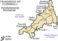 By 1841 Cornwall was composed of ten Hundred
s as listed below here:

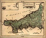
Cornwall
Cornwall is a unitary authority and ceremonial county of England, within the United Kingdom. It is bordered to the north and west by the Celtic Sea, to the south by the English Channel, and to the east by the county of Devon, over the River Tamar. Cornwall has a population of , and covers an area of...
was from Anglo-Saxon times until the 19th century divided into hundreds, some with the suffix shire as in Pydarshire, East and West Wivelshire and Powdershire which were first recorded as names between 1184-1187. In the Cornish language
Cornish language
Cornish is a Brythonic Celtic language and a recognised minority language of the United Kingdom. Along with Welsh and Breton, it is directly descended from the ancient British language spoken throughout much of Britain before the English language came to dominate...
the word for "hundred" is keverang (pl. keverangow) and is the equivalent of the Welsh cantref. The word, in its plural form, appears in place names like Meankeverango in 1580 (now The Enys, north of Prussia Cove
Prussia Cove
Prussia Cove , formerly called the King's Cove, is a small private estate on the coast of Mount's Bay and to the east of Cudden Point, west Cornwall, UK. Part of the area is designated as a Site of Special Scientific Interest , a Geological Conservation Review site and is in an Area of Outstanding...
and marking the southern end of the boundary between the former districts of Penwith
Penwith
Penwith was a local government district in Cornwall, England, United Kingdom, whose council was based in Penzance. The district covered all of the Penwith peninsula, the toe-like promontory of land at the western end of Cornwall and which included an area of land to the east that fell outside the...
and Kerrier
Kerrier
Kerrier was a local government district in Cornwall, England, United Kingdom. It was the most southerly district in the United Kingdom, other than the Isles of Scilly. Its council was based in Camborne ....
), and Assa Govranckowe 1580, Kyver Ankou c. 1720, also on the Penwith - Kerrier border near Scorrier
Scorrier
Scorrier is a village in Cornwall, in the United Kingdom. It is about 2 miles northeast of the centre of Redruth and 3 miles south-east of the coast at Porthtowan, on the A30 road at the junction of the A3047 road that leads west to Camborne and the B3298 road south to Carharrack...
. It is also found in the singular form at Buscaverran, just south of Crowan
Crowan
Crowan is a village and civil parish in Cornwall, United Kingdom. It is situated approximately three-and-a-half miles south of Camborne. The River Hayle rises near Crowan and flows through the village and the railway branch to Helston passed nearby. Crowan has a population of 2,375...
churchtown and also on the Penwith-Kerrier border. The hundred of Trigg is mentioned by name during the 7th century, as "Pagus Tricurius", "land of three war hosts".
History
Wessex
The Kingdom of Wessex or Kingdom of the West Saxons was an Anglo-Saxon kingdom of the West Saxons, in South West England, from the 6th century, until the emergence of a united English state in the 10th century, under the Wessex dynasty. It was to be an earldom after Canute the Great's conquest...
into hundreds is thought to date from the reign of King Athelstan, and in the Geld Inquest of 1083, only seven hundreds are found in Cornwall, identified by the names of the chief manors of each: Connerton, Winnianton, Pawton, Tybesta, Stratton, Fawton and Rillaton (corresponding to Penwith, Kerrier, Pydar, Powder, Trigg, West Wivel and East Wivel). At the time of the Domesday Survey of 1086, the internal order of the Cornish manor
Manor
-Land tenure:*Manor, an estate in land of the mediaeval era in England*Manorialism, a system of land tenure and organization of the rural economy and society in parts of medieval Europe based on the manor*Manor house, the principal house of a manor...
s in the Exeter Domesday Book
Liber Exoniensis
The Liber Exoniensis or Exon Domesday is a composite land and tax register associated with the Domesday Survey of 1086, covering much of Southwest England. It contains a variety of administrative materials concerning the shires of Cornwall, Devon, Dorset, Somerset and Wiltshire...
is in most cases based on the hundreds to which they belonged, although the hundred names are not used.
All of the lordships of the Hundreds of Cornwall belonged, and still belong, to the Duchy of Cornwall
Duchy of Cornwall
The Duchy of Cornwall is one of two royal duchies in England, the other being the Duchy of Lancaster. The eldest son of the reigning British monarch inherits the duchy and title of Duke of Cornwall at the time of his birth, or of his parent's succession to the throne. If the monarch has no son, the...
, apart from Penwith which belonged to the Arundells of Lanherne. The Arundells sold their lordship to the Hawkins family in 1813 and the Hawkinses went on to sell it to the Paynters in 1832. The Lordship of Penwith came with a great number of rights over the entire hundred. These included: rights to try certain cases of trespass
Trespass
Trespass is an area of tort law broadly divided into three groups: trespass to the person, trespass to chattels and trespass to land.Trespass to the person, historically involved six separate trespasses: threats, assault, battery, wounding, mayhem, and maiming...
, trespass on the law, debt and detinue
Detinue
In tort law, detinue is an action to recover for the wrongful taking of personal property. It is initiated by an individual who claims to have a greater right to their immediate possession than the current possessor...
, to appoint a jailor for the detention of persons apprehended, to receive high-rent from the lords of the principal manors
Manorialism
Manorialism, an essential element of feudal society, was the organizing principle of rural economy that originated in the villa system of the Late Roman Empire, was widely practiced in medieval western and parts of central Europe, and was slowly replaced by the advent of a money-based market...
and to claim the regalia
Regalia
Regalia is Latin plurale tantum for the privileges and the insignia characteristic of a Sovereign.The word stems from the Latin substantivation of the adjective regalis, 'regal', itself from Rex, 'king'...
of the navigable rivers and havens, the profits of the royal gold and silver mines
Royal Mines Act 1424
The Royal Mines Act 1424 was an act of the Parliament of Scotland stating that gold and silver mines containing ore above a certain value would belong to the king....
, and all wrecks
Receiver of Wreck
The Receiver of Wreck is an official who administers law dealing with wreck and salvage in some countries having a British administrative heritage.-Countries having a Receiver of Wreck:...
, escheat
Escheat
Escheat is a common law doctrine which transfers the property of a person who dies without heirs to the crown or state. It serves to ensure that property is not left in limbo without recognised ownership...
s, deodand
Deodand
Deodand is a thing forfeited or given to God, specifically, in law, an object or instrument which becomes forfeit because it has caused a person's death....
s, treasure trove
Treasure trove
A treasure trove may broadly be defined as an amount of money or coin, gold, silver, plate, or bullion found hidden underground or in places such as cellars or attics, where the treasure seems old enough for it to be presumed that the true owner is dead and the heirs undiscoverable...
, waifs
Waif
A waif is a living creature removed, by hardship, loss or other helpless circumstance, from his original surroundings...
, estray
Estray
Estray, in law, is any domestic animal found wandering at large or lost, particularly if the owner is unknown.Under early English common law, estrays were forfeited to the king or lord of the manor; under modern statutes, provision is made for taking up stray animals and acquiring either title to...
s, goods of felons and droits of admiralty
Droit
A droit is a legal title, claim or due.-Droits of admiralty :The term is used in English law in the phrase "droits of admiralty". This refers to certain customary rights or perquisites, formerly belonging to the Lord High Admiral, but now to the crown, for public purposes and paid into the...
happening within the hundred.
Origin of the hundred names
The origins of the names have puzzled some earlier writers on the subject: Penwith is certainly the name of Land's End in Cornish (earliest occurrence in the Anglo-Saxon Chronicle for 997); Kerrier (sometimes Kirrier) is thought by Thomas to be derived from an obsolete name (ker hyr = long fort) of Castle Pencaire on Tregonning Hill, BreageBreage, Cornwall
Breage is a civil parish and village in Cornwall, England, United Kingdom. The village is situated three miles west of Helston....
; Lesnewth denotes a place where a 'new court' has been established (the 'old court' having been at Henlis(-ton): Helstone
Helstone
Helstone is a settlement in north Cornwall, United Kingdom. It is situated two miles southwest of Camelford on the A39 road.-History:...
, formerly Helston-in-Trigg); Powder has no certain derivation: 'pou' must mean 'territory' in Cornish; Pydar (or Pyder) has been variously explained: perhaps it derives from a Cornish word meaning 'a fourth part'; Stratton
Stratton, Cornwall
Stratton is a small town situated near the coastal resort of Bude in north Cornwall, UK. It was also the name of one of ten ancient administrative shires of Cornwall - see "Hundreds of Cornwall"...
was at the time of Domesday an important manor and 200 years earlier it is mentioned as 'Strætneat' (etym. dub.); Trigg
Triggshire
The hundred of Trigg was one of ten ancient administrative shires of Cornwall--see "Hundreds of Cornwall".Trigg is mentioned by name during the 7th century, as "Pagus Tricurius", "land of three war hosts". It was to the north of Cornwall, and included Bodmin Moor, Bodmin and the district to the...
is explained in the separate article; East and West (Wivelshire
Wivelshire
East Wivelshire and West Wivelshire are two of the ancient Hundreds of Cornwall.East and West must have originally had a Cornish name but it is not recorded - see Lost wydhyel; the second element gwydhyow meaning 'trees' -...
) must have originally had a Cornish name but it is not recorded (Wivel may be from an Anglo-Saxon personal name 'Wifel').
List of hundreds in 1841
Hundred (division)
A hundred is a geographic division formerly used in England, Wales, Denmark, South Australia, some parts of the United States, Germany , Sweden, Finland and Norway, which historically was used to divide a larger region into smaller administrative divisions...
s as listed below here:
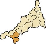
- PenwithPenwith (hundred)The hundred of Penwith was the name of one of ten ancient administrative shires of Cornwall, England. The ancient hundred of Penwith was larger than the local government district of Penwith which took its name...
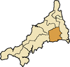
(Penwyth) - KerrierKerrier (hundred)The hundred of Kerrier was the name of one of ten ancient administrative shires of Cornwall, in the United Kingdom. Kerrier is thought by Charles Thomas to be derived from an obsolete name of Castle Pencaire on Tregonning Hill, Breage...
(Keryer) - Pydarshire (Pedera)
- Powdershire (Pow Ereder)
- TriggshireTriggshireThe hundred of Trigg was one of ten ancient administrative shires of Cornwall--see "Hundreds of Cornwall".Trigg is mentioned by name during the 7th century, as "Pagus Tricurius", "land of three war hosts". It was to the north of Cornwall, and included Bodmin Moor, Bodmin and the district to the...
(Trigor) - LesnewthLesnewth (hundred)Lesnewth Hundred is one of the former hundreds of Cornwall, Trigg was to the south-west and Stratton Hundred to the north-east. Tintagel, Camelford, Boscastle, and Altarnun were in the Hundred of Lesnewth as well as Lesnewth which is now only a small village but in Celtic times was the seat of a...
(Lysnowyth) - Stratton (Stradneth)
- East Wivelshire (Ryslegh)
- West Wivelshire (Fawy)
- Scilly
Penwith
- St BuryanSt BuryanSt Buryan is a civil parish and village in Cornwall, United Kingdom.The village of St Buryan is situated approximately five miles west of Penzance along the B3283 towards Land's End...
, CamborneCamborneCamborne is a town and civil parish in west Cornwall, England, United Kingdom. It is at the western edge of a conurbation comprising Camborne, Pool and Redruth....
, CrowanCrowanCrowan is a village and civil parish in Cornwall, United Kingdom. It is situated approximately three-and-a-half miles south of Camborne. The River Hayle rises near Crowan and flows through the village and the railway branch to Helston passed nearby. Crowan has a population of 2,375...
, St ErthSt ErthSt Erth is a civil parish and village in Cornwall, United Kingdom.The village is situated four miles southeast of St Ives and six miles northeast of Penzance....
, GulvalGulvalGulval is a village in the former Penwith district of Cornwall, United Kingdom. Although historically a parish in its own right, Gulval was incorporated into the parishes of Penzance, Madron and Ludgvan in 1934, and like Heamoor, is now considered to be a suburb of Penzance...
[alias Lanisly], GwinearGwinear-GwithianGwinear–Gwithian is a coastal civil parish in west Cornwall, United Kingdom. It includes the villages of Connor Downs, Gwinear, Gwithian, Reawla and Rosewarne...
, GwithianGwithianbeach2Gwithian is a coastal village in west Cornwall, United Kingdom. It is situated three miles northeast of Hayle and four miles east of St Ives, Cornwall across St Ives Bay....
, St HilarySt Hilary, CornwallSt Hilary is a civil parish and village in west Cornwall, United Kingdom. It is situated approximately five miles east of Penzance and four miles south of Hayle.Chynoweth is an area immediately north of St Hilary....
, IlloganIlloganIllogan is a village and civil parish in Cornwall, United Kingdom. It is situated two miles northwest of Redruth.Originally a rural area supporting itself by farming and agriculture, Illogan shared in the general leap into prosperity brought about by the mining boom, which was experienced by the...
, St IvesSt Ives, CornwallSt Ives is a seaside town, civil parish and port in Cornwall, England, United Kingdom. The town lies north of Penzance and west of Camborne on the coast of the Celtic Sea. In former times it was commercially dependent on fishing. The decline in fishing, however, caused a shift in commercial...
, St Just in PenwithSt Just in PenwithSt Just is a town and civil parish in Cornwall, England, United Kingdom. The parish encompasses the town of St Just and the nearby settlements of Trewellard, Pendeen and Kelynack: it is bounded by the parishes of Morvah to the north-east, Sancreed and Madron to the east, St Buryan and Sennen to...
, LelantLelantLelant is a village in west Cornwall, England, UK. It is on the west side of the River Hayle estuary about 2½ miles southeast of St Ives and one mile west of Hayle....
[Uny Lelant], St LevanSt LevanSt Levan is a civil parish and village in Cornwall, United Kingdom. The village is situated approximately eight miles south west of Penzance....
, LudgvanLudgvanLudgvan is a civil parish and village in Cornwall, England, UK. The village is situated 2½ miles northeast of Penzance.The parish includes the villages of Ludgvan, Crowlas, Canon's Town and Long Rock...
, MadronMadronMadron is a civil parish and village in west Cornwall, United Kingdom. It is a large rural parish on the Penwith peninsula north of Penzance.Madron village is situated approximately two miles northwest of Penzance town centre....
, MorvahMorvahMorvah is a civil parish and village on the Penwith peninsula in west Cornwall, United Kingdom. The village is situated approximately eight miles west-southwest of St Ives and 5½ miles north-west of Penzance....
, PaulPaul, CornwallPaul is a civil parish and village in Cornwall, United Kingdom. It is situated two miles south of Penzance and one mile south of Newlyn.The village of Paul is represented on Penzance Town Council...
, PerranuthnoePerranuthnoePerranuthnoe is a civil parish and a village in southwest Cornwall, United Kingdom. The village is situated on the east side of Mount's Bay approximately one mile east of Marazion and four miles east of Penzance....
, PhillackPhillackPhillack is a village in west Cornwall, United Kingdom. It is situated approximately one mile northeast of Hayle and half-a-mile inland from St Ives Bay on Cornwall's Atlantic coast...
, RedruthRedruthRedruth is a town and civil parish traditionally in the Penwith Hundred in Cornwall, United Kingdom. It has a population of 12,352. Redruth lies approximately at the junction of the A393 and A3047 roads, on the route of the old London to Land's End trunk road , and is approximately west of...
, SancreedSancreedSancreed is a village and civil parish in Cornwall, United Kingdom. The village is situated approximately three miles from Penzance....
, SennenSennenSennen is a coastal civil parish and a village in Cornwall, United Kingdom. Sennen village is situated approximately eight miles west-southwest of Penzance....
, TowednackTowednackTowednack is a village and civil parish in Cornwall, United Kingdom. The parish is bounded by those of Zennor in the west, Gulval in the south, Ludgvan in the east and St Ives in the north...
, ZennorZennorZennor is a village and civil parish in Cornwall in England. The parish includes the villages of Zennor, Boswednack and Porthmeor and the hamlet of Treen. It is located on the north coast, about north of Penzance. Alphabetically, the parish is the last in Britain—its name comes from the Cornish...
.
Kerrier
- St Anthony-in-MeneageSt Anthony-in-MeneageSt Anthony-in-Meneage is a coastal civil parish and village in Cornwall, United Kingdom. The parish is in the Meneage district of The Lizard peninsula...
, BreageBreageBreage, also known as Breaca, Briac, etc., is a saint venerated in Cornwall and southwestern Britain. According to her late hagiography, she was an Irish nun of the 5th or 6th century who founded a church in Cornwall...
, Budock, ConstantineConstantine, KerrierConstantine is a village and civil parish in Cornwall, United Kingdom. It is situated approximately five miles west-southwest of Falmouth....
, CuryCuryCury is a civil parish and village in southwest Cornwall, United Kingdom. It is situated approximately four miles south of Helston on The Lizard peninsula. The parish is named for St Corentin and is recorded in the Domesday Book as Chori....
, FalmouthFalmouth, CornwallFalmouth is a town, civil parish and port on the River Fal on the south coast of Cornwall, England, United Kingdom. It has a total resident population of 21,635.Falmouth is the terminus of the A39, which begins some 200 miles away in Bath, Somerset....
, GermoeGermoeGermoe is a village and civil parish in Cornwall, United Kingdom. Germoe village, the parish's principal settlement and church town, is situated approximately five miles west of Helston and seven miles east of Penzance. The A394 Penzance to Helston road runs along the southern boundary of the...
, St GluviasSt GluviasSt Gluvias is a civil parish and settlement in Cornwall, United Kingdom. The village is now a suburb on the northern edge of Penryn which is situated two miles northwest of Falmouth.-Church history:...
, GradeGrade-RuanGrade–Ruan is a civil parish on the Lizard peninsula in Cornwall, England, United Kingdom approximately ten miles south of Falmouth....
, GunwalloeGunwalloeGunwalloe is a coastal civil parish and a village in Cornwall, United Kingdom. It is situated on the Lizard Peninsula three miles south of Helston and partly contains The Loe, the largest natural freshwater lake in Cornwall.-History:...
[alias Winnington], GwennapGwennapGwennap is a village and civil parish in Cornwall, United Kingdom. It is situated approximately five miles southeast of Redruth....
with St DaySt DaySt Day is a civil parish and village in Cornwall, United Kingdom. It is situated between the village of Chacewater and the town of Redruth.St Day is located in a former mining area and St Day accrued considerable wealth from mining...
, HelstonHelstonHelston is a town and civil parish in Cornwall, England, United Kingdom. It is situated at the northern end of the Lizard Peninsula approximately 12 miles east of Penzance and nine miles southwest of Falmouth. Helston is the most southerly town in the UK and is around further south than...
, St KeverneSt KeverneSt Keverne is a civil parish and village on the Lizard Peninsula in Cornwall, United Kingdom.The Cornish Rebellion of 1497 started in St Keverne. The leader of the rebellion Michael An Gof was a blacksmith from St Keverne and is commemorated by a statue in the village...
, LandewednackLandewednackLandewednack is a civil parish and a hamlet in Cornwall, United Kingdom. The hamlet is situated approximately ten miles south of Helston.Landewednack is the most southerly parish on the British mainland...
, MabeMabe, CornwallMabe is a village and civil parish in Cornwall, United Kingdom. The village is situated one mile west of Penryn....
, ManaccanManaccanManaccan is a civil parish and village on the Lizard peninsula in south Cornwall, England, United Kingdom. The village is situated approximately five miles south-southwest of Falmouth....
, St Martin-in-MeneageSt Martin-in-MeneageSt Martin-in-Meneage is a civil parish and village in the Meneage district of the Lizard Peninsula in Cornwall, United Kingdom.The village is five miles south-southeast of Helston....
, Mawgan-in-MeneageMawgan-in-MeneageMawgan-in-Meneage is a civil parish in Cornwall, United Kingdom. It is situated in the Meneage district of The Lizard peninsula south of Helston in the former administrative district of Kerrier....
, MawnanMawnanMawnan is a civil parish in south Cornwall, United Kingdom . It is situated in the former administrative district of Kerrier and is bounded to the south by the Helford River, to the east by the sea, and to the west by Constantine parish...
, MullionMullion, CornwallMullion is a civil parish and village in Cornwall, United Kingdom. It is situated on the Lizard Peninsula approximately five miles south of Helston....
, Mylor, PerranarworthalPerranarworthalPerranarworthal is a civil parish and village in Cornwall, United Kingdom. The village is situated approximately four miles northwest of Falmouth and five miles southwest of Truro....
, Ruan Major, Ruan MinorGrade-RuanGrade–Ruan is a civil parish on the Lizard peninsula in Cornwall, England, United Kingdom approximately ten miles south of Falmouth....
, SithneySithneySithney is a village and civil parish in Cornwall, England, United Kingdom. It is named for Saint Sithney, the patron saint of the parish church....
, St StithiansStithiansStithians is a village and civil parish in Cornwall, England, in the United Kingdom. It lies in the centre of the triangle bounded by Redruth, Helston and Falmouth. Its population is 2,004....
, WendronWendronWendron is a village and civil parish in Cornwall, United Kingdom. It is situated three miles north of Helston.The Revd G. H. Doble served for almost twenty years as the Vicar of Wendron . Langdon recorded the existence of eight stone crosses in the parish, including two at Merther Uny...
Pydarshire
- St AgnesSt Agnes, CornwallSt Agnes is a civil parish and a large village on the north coast of Cornwall, United Kingdom. The village is situated approximately five miles north of Redruth and ten miles southwest of Newquay....
, St BreockSt BreockSt Breock is a village and a civil parish in north Cornwall, United Kingdom. St Breock village is 1 mile west of Wadebridge immediately to the south of the Royal Cornwall Showground. The village lies on the eastern slope of the wooded Nansent valley...
, ColanColan, CornwallColan is a village and civil parish in mid-Cornwall, UK. It is situated approximately three miles east of Newquay.Fir Hill Manor, which once belonged to the Hoblyn family of Colan, was the subject of a BBC Bristol documentary, The Curse of Fir Hill Manor...
, St Columb MinorSt Columb MinorSt Columb Minor is a village on the north coast of Cornwall, UK. St. Columb alone by default refers to the nearby St. Columb Major.At one time St Columb Minor used to be the main settlement in the area, but it has now been encroached upon by its larger neighbour Newquay. The National School in the...
& St Columb MajorSt Columb MajorSt Columb Major is a civil parish and town in Cornwall, England, United Kingdom. Often referred to locally as St Columb, it is situated approximately seven miles southwest of Wadebridge and six miles east of Newquay...
, CrantockCrantockCrantock is a coastal civil parish and a village in Cornwall, England, United Kingdom. The village is approximately two miles southwest of Newquay....
, CubertCubertCubert is a civil parish and village in Cornwall, United Kingdom. It is situated three miles south-southwest of Newquay.Once known as St Cubert, the village is dominated by the spire of its 14th century church which was enlarged by the addition of a south aisle a century later.The village is named...
, St EnoderSt EnoderSt. Enoder is a civil parish and village in Cornwall, United Kingdom. The village is situated five miles southeast of Newquay.The nearest village is Summercourt half-a-mile to the south and other settlements include Fraddon, Penhale, Indian Queens and Trevarren.The parish church is 15th century...
, St ErvanSt ErvanSt Ervan is a rural civil parish and hamlet in Cornwall, United Kingdom. The hamlet is situated three miles southwest of Padstow. Notable features in St Ervan are the Anglican church, the village hall and the Nonconformist cemetery,...
, St EvalSt EvalSt Eval is a civil parish and hamlet in north Cornwall, United Kingdom. The hamlet is situated approximately four miles southwest of Padstow....
, St IsseySt IsseySt Issey is a civil parish and village in Cornwall, United Kingdom. It is situated approximately two miles south of Padstow. The parish covers an area of approximately .-History:...
, Lanhydrock, LanivetLanivetLanivet is a village and civil parish in Cornwall, United Kingdom. The village is situated approximately 2½ miles southwest of Bodmin. The Saints' Way long-distance footpath passes Lanivet near its half-way point....
, St Mawgan-in-PydarSt MawganSt Mawgan in Pydar is a civil parish in Cornwall, United Kingdom. The village of St Mawgan is situated four miles northeast of Newquay....
, St MerrynSt MerrynSt Merryn is a civil parish and village in north Cornwall, United Kingdom approximately three and a half miles south of the fishing port of Padstow and approximately 11 miles northeast of the coastal resort of Newquay....
, St Newlyn EastSt Newlyn EastSt Newlyn East is a civil parish and village in Cornwall, United Kingdom. The village is situated approximately three miles south of Newquay...
, PadstowPadstowPadstow is a town, civil parish and fishing port on the north coast of Cornwall, England, United Kingdom. The town is situated on the west bank of the River Camel estuary approximately five miles northwest of Wadebridge, ten miles northwest of Bodmin and ten miles northeast of Newquay...
, PerranzabuloePerranzabuloePerranzabuloe is a coastal civil parish and a hamlet in Cornwall, United Kingdom. The hamlet is situated just over a mile south of the principal settlement of the parish, Perranporth; the hamlet is also seven miles south-southwest of Newquay...
, Little PetherickLittle PetherickLittle Petherick is a village and civil parish in north Cornwall, United Kingdom. It is situated two miles south of Padstow and 6 miles west of Wadebridge....
, St WennSt WennSt Wenn is a civil parish and village in Cornwall, United Kingdom. The village is situated six miles west of Bodmin and nine miles east of Newquay....
, WithielWithielWithiel is a civil parish and village in Cornwall, United Kingdom. The name Withiel is derived from the Cornish word Gwydhyel, meaning wooded place...
Powdershire
- St AllenSt AllenSt Allen is a civil parish in Cornwall, United Kingdom. The church town of St Allen is an isolated hamlet and the main settlement in the parish is Zelah which is situated on the A30 trunk road four miles north of Truro....
, St Anthony-in-Roseland, St AustellSt AustellSt Austell is a civil parish and a major town in Cornwall, England, United Kingdom. It is situated on the south coast approximately ten miles south of Bodmin and 30 miles west of the border with Devon at Saltash...
, St BlazeySt BlazeySt Blazey is a small town in Cornwall, United Kingdom.St Blaise is the civil parish in which St Blazey is situated; the name St Blaise is also used by the town council.St Blazey is situated east of St Austell...
, St ClementSt Clement, CornwallSt Clement is a civil parish and village in Cornwall, United Kingdom. It is situated southeast of Truro in the valley of the Tresillian River. There is a smaller village at Malpas in the south of the parish...
, Cornelly, CreedCreed, CornwallCreed is a village in Cornwall, United Kingdom. It is situated roughly midway between Truro and St Austell approximately two miles east of Probus....
-with-GrampoundGrampoundGrampound is a village in Cornwall, England, United Kingdom. It is situated on the A390 road six miles west of St Austell.Grampound with Creed is the civil parish of which the village of Grampound and the village of Creed are the main settlements...
, CubyCuby, CornwallCuby is a civil parish and village in Cornwall, United Kingdom, situated approximately 7 miles south-west of St Austell.Cornelly parish was united with Cuby in 1934....
-with-TregonyTregonyTregony is a civil parish and village in Cornwall, United Kingdom. It lies on the River Fal. In the village there is a post office, shop, and two churches. Tregony has bus links to the nearest town, which is Truro. The village is made up from two parishes namely, Tregony and Cuby...
, St Dennis, St ErmeSt ErmeSt Erme is a civil parish and village in Cornwall, England, in the United Kingdom. The parish of St Erme, has a population of approximately 1200...
, St EweSt EweSt Ewe is a civil parish and village in mid-Cornwall, United Kingdom. The village is situated approximately five miles southwest of St Austell.-Antiquities:...
, FeockFeock, CornwallFeock is a coastal civil parish and village in Cornwall, United Kingdom. It is situated approximately 5 miles south of Truro at the head of Carrick Roads on the River Fal. To the south, the parish is bounded by Restronguet Creek and to the east by Carrick Roads and the River Fal...
, FoweyFoweyFowey is a small town, civil parish and cargo port at the mouth of the River Fowey in south Cornwall, United Kingdom. According to the 2001 census it had a population of 2,273.-Early history:...
, GerransGerransGerrans is a coastal civil parish and village on the Roseland Peninsula in Cornwall, United Kingdom. The village adjoins Portscatho on the east side of the peninsula...
, GorranSt GoranSt. Goran is a coastal civil parish in Cornwall, United Kingdom. The church town, Gorran Churchtown, is situated approximately six miles south-southwest of St Austell. However, the largest settlement in the parish is the coastal village of Gorran Haven, a mile to the east.The parish is bounded by...
, St Just-in-Roseland, KeaKea, CornwallKea is a civil parish and village in Cornwall, United Kingdom. It is a "large straggling parish" in a former mining area south of Truro.Kea village is situated just over one mile southwest of Truro....
, KenwynKenwynKenwyn is a settlement and civil parish in Cornwall, United Kingdom. The settlement is a suburb of the city of Truro and is situated half-a-mile north of the city centre. It gives its name to one of three rivers that flow through the city....
, LadockLadockLadock is a village and civil parish in Cornwall, United Kingdom. It is situated approximately six miles northeast of Truro.Historically, Ladock was two small settlements; Bissick by the river and Ladock on the hill...
, Lamorran, LanliveryLanliveryLanlivery is a village and civil parish in Cornwall, United Kingdom. The village is located approximately 1½ miles west of Lostwithiel and five miles south of Bodmin....
, LostwithielLostwithielLostwithiel is a civil parish and small town in Cornwall, England, United Kingdom at the head of the estuary of the River Fowey. According to the 2001 census it had a population of 2,739...
, LuxulyanLuxulyanLuxulyan , also spelled Luxullian or Luxulian, is a village and civil parish in central Cornwall, United Kingdom. The village lies four miles northeast of St Austell and six miles south of Bodmin...
, Merther, MevagisseyMevagisseyMevagissey is a village, fishing port and civil parish in Cornwall, United Kingdom. The village is situated approximately five miles south of St Austell....
, St MewanSt MewanSt Mewan is a civil parish and village in south Cornwall, United Kingdom.The village is approximately one mile west of St Austell. It is a small settlement, comprising the parish church, rectory, a school and nearby farms...
, St Michael CaerhaysSt Michael CaerhaysSt Michael Caerhays is a civil parish and village in Cornwall, United Kingdom. The village is situated approximately seven miles south-southwest of St Austell....
, St Michael Penkevil, PhilleighPhilleighPhilleigh is a civil parish and village in Cornwall, England, in the United Kingdom, one of the four in the Roseland Peninsula.-History:The Manor of Eglosrose is mentioned in the Domesday Book and the remainder of the parish was in the episcopal Manor of Tregear. The parish church is dedicated to...
, ProbusProbus, CornwallProbus is a civil parish and village in Cornwall, England, in the United Kingdom. It is famous for having the tallest church tower in Cornwall. The tower is high, and richly decorated with carvings...
, RocheRoche, CornwallRoche is a civil parish and village in mid-Cornwall, England, United Kingdom. The village gets its name from a granite outcrop east of the village. Roche is the Norman-French word for Rock....
, Ruan Lanihorne, St Sampson GolantGolantGolant is a village in south Cornwall, United Kingdom. It is situated on the west bank of the River Fowey and lies in the civil parish of St Sampson....
, St Stephen-in-BrannelSt Stephen-in-BrannelSt Stephen-in-Brannel is a civil parish and village in central Cornwall, United Kingdom. St Stephen village is four miles west of St Austell on the southern edge of Cornwall's china clay district.In medieval times the parish lay within the royal manor of Brannel...
, Truro St MaryTruroTruro is a city and civil parish in Cornwall, England, United Kingdom. The city is the centre for administration, leisure and retail in Cornwall, with a population recorded in the 2001 census of 17,431. Truro urban statistical area, which includes parts of surrounding parishes, has a 2001 census...
, TywardreathTywardreathTywardreath is a small hilltop village in southern Cornwall, United Kingdom. about north west of Fowey. It is located in a sheltered spot overlooking a silted up estuary opposite Par and near the beach of Par Sands...
, VeryanVeryanVeryan is a coastal civil parish and a village on the Roseland Peninsula in Cornwall, United Kingdom. The main settlements are at Veryan Churchtown, Veryan Green, Portloe and the smaller hamlets of Trewartha, Treviskey, Carne and Camels...
Triggshire
- BodminBodminBodmin is a civil parish and major town in Cornwall, England, United Kingdom. It is situated in the centre of the county southwest of Bodmin Moor.The extent of the civil parish corresponds fairly closely to that of the town so is mostly urban in character...
, BlislandBlislandBlisland is a village and civil parish in Cornwall, England, United Kingdom. It is approximately five miles northeast of Bodmin. According to the 2001 census, the parish had a population of 565....
, St BrewardSt BrewardSt Breward is a civil parish and village in Cornwall, England, United Kingdom. It is situated on the western side of Bodmin Moor approximately 6 miles north of Bodmin.The parish name derives from Saint Branwalader...
, EgloshayleEgloshayleEgloshayle is a civil parish and village in north Cornwall, England, United Kingdom. The village is situated beside the River Camel immediately southeast of Wadebridge. The civil parish extends southeast from the village and includes Washaway and Sladesbridge.-History:Egloshayle was a Bronze Age...
, St EndellionSt EndellionSt Endellion is a civil parish and village in north Cornwall, England, United Kingdom. The village and parish church are situated four miles north of Wadebridge....
, HellandHellandHelland is a civil parish and village in Cornwall, United Kingdom. It is situated 2½ miles north of Bodmin. The meaning of the name Helland is unclear: it is possible that the origin is in Cornish hen & lan...
, St Kew, St MabynSt MabynSt Mabyn is a civil parish and village in Cornwall, England, United Kingdom. The village is situated three miles east of Wadebridge....
, St MinverSt MinverSt Minver is the name of an ecclesiastical parish, a civil parish and a village in north Cornwall, United Kingdom.The civil parish of St Minver is in Bodmin Registration District and is nominally divided into St Minver Highlands and St Minver Lowlands .The combined parish is bounded on the south...
, St TeathSt TeathSt Teath is civil parish and village in north Cornwall, United Kingdom. The village is situated approximately three miles southwest of Camelford and seven miles northeast of Wadebridge. The hamlet of Whitewell lies to the west....
, TempleTemple, CornwallTemple is a hamlet in the parish of Blisland on Bodmin moor, Cornwall, UK. The hamlet is bypassed by the A30 road.-History and antiquities:...
, St TudySt TudySt Tudy is a civil parish and village in north Cornwall, United Kingdom. The village is situated in the River Camel valley approximately five miles northeast of Wadebridge.-Parish church:...
.
Lesnewth
- AdventAdvent, CornwallAdvent is a civil parish on the north-western edge of Bodmin Moor in north Cornwall, England, United Kingdom. It is named after St Adwenna and lies in the Registration District of Camelford....
, AltarnunAltarnunAltarnun is a village and civil parish in Cornwall, United Kingdom. It is located on the north-eastern edge of Bodmin Moor at .The parish of Altarnun includes the village of Fivelanes and the hamlets of Bolventor, Treween and Trewint, and had a population of 976 according to the 2001 census...
, St CletherSt CletherSt Clether is a civil parish and village in Cornwall, United Kingdom. The village is situated on the east flank of Bodmin Moor approximately eight miles west of Launceston in the valley of the River Inny....
, DavidstowDavidstowDavidstow is a civil parish and village in north Cornwall, United Kingdom. The village is north of Bodmin Moor straddling the A395 road about 3 miles north of Camelford....
, Forrabury, St GennysSt GennysSt Gennys is a coastal civil parish and small settlement in north Cornwall, United Kingdom.The hamlet of St Gennys is situated approximately seven miles southwest of Bude. It is on high ground half-a-mile north of the coastal village of Crackington Haven, the major settlement in the parish...
, St JuliotSt JuliotSt Juliot is a civil parish in north-east Cornwall, United Kingdom. The parish is entirely rural and the only settlements are the hamlets of Beeny and Tresparrett.-Parish Church:...
, Lanteglos-by-CamelfordCamelfordCamelford is a town and civil parish in north Cornwall, United Kingdom, situated in the River Camel valley northwest of Bodmin Moor. The town is approximately ten miles north of Bodmin and is governed by Camelford Town Council....
, LesnewthLesnewthLesnewth is a civil parish and village in Cornwall, United Kingdom. It is situated approximately six miles east of Tintagel Head and two miles east of Boscastle....
, MichaelstowMichaelstowMichaelstow is a civil parish and village in north Cornwall, United Kingdom. The village is situated approximately three miles south of Camelford.The civil parish of Michaelstow is in the deanery of Trigg Minor and Hundred of Lesnewth. It...
, Minster, OtterhamOtterhamOtterham is a village and a civil parish in north Cornwall, United Kingdom. The village is situated approximately ten miles south of Bude and six miles north of Camelford....
, PoundstockPoundstockPoundstock is a civil parish and a hamlet on the north coast of Cornwall, United Kingdom. The hamlet is situated four miles south of Bude half-a-mile west of the A39 trunk road about one mile from the coast....
, TintagelTintagelTintagel is a civil parish and village situated on the Atlantic coast of Cornwall, United Kingdom. The population of the parish is 1,820 people, and the area of the parish is ....
[with Bossiney], TreneglosTreneglosTreneglos is a hamlet and a civil parish in north-east Cornwall, United Kingdom. It is in the Registration District of Launceston.The civil parish is bounded to the north by Warbstow parish, to the east by Tremaine and Tresmere parishes, and to the west by Davidstow parish...
, TrevalgaTrevalgaTrevalga is a coastal civil parish and village in north Cornwall, United Kingdom. The parish is bounded on the north by the Atlantic Ocean, on the south-east by Forrabury and Minster parish and on the west by Tintagel parish....
, WarbstowWarbstowWarbstow is a village and civil parish in Cornwall, England, United Kingdom. The parish has a population of 439 according to the 2001 census.The parish is one of the few left in England to still have an exclave...
.
Stratton
- BoytonBoyton, CornwallBoyton is a civil parish and village in Cornwall, United Kingdom. It is situated close to the River Tamar and the border with Devon about six miles north of Launceston. According to the 2001 census it had a population of 378....
, BridgeruleBridgeruleBridgerule is a village and civil parish in Devon, England, a mile from the border with Cornwall. The parish is divided by the River Tamar, which no longer forms the border between Devon and Cornwall there. The river frequently floods the High Street....
, JacobstowJacobstowJacobstow is a civil parish and village in north Cornwall, United Kingdom. The village is located east of the A39 road approximately seven miles south of Bude....
, KilkhamptonKilkhamptonKilkhampton is a village and civil parish in northeast Cornwall, United Kingdom. The village is situated on the A39 approximately four miles north-northeast of Bude.Kilkhampton was mentioned in the Domesday Book as "Chilchetone"...
, LauncellsLauncellsLauncells is a hamlet and civil parish in north-east Cornwall, United Kingdom. It is located three miles east of Bude.The civil parish contains other settlements of Red Post and Grimscott...
, MarhamchurchMarhamchurchMarhamchurch is a civil parish and village in north Cornwall, United Kingdom.Marhamchurch village is situated 1½ miles south of Bude off the A39 road.-History:...
, MorwenstowMorwenstowthumb|Parish Church of St Morwenna and St John the Baptist, MorwenstowMorwenstow is a civil parish and hamlet in north Cornwall, United Kingdom. The hamlet is situated near the coast approximately six miles north of Bude....
, PoughillPoughillPoughill is a hamlet in north-east Cornwall, United Kingdom. It is located one mile north of Bude .-History and notable buildings:Poughill is mentioned in the Domesday Book as Pochelle. Notable old houses in Poughill include Burshill Manor , an open hall house, and Church House, dated 1525.The...
, StrattonStratton, CornwallStratton is a small town situated near the coastal resort of Bude in north Cornwall, UK. It was also the name of one of ten ancient administrative shires of Cornwall - see "Hundreds of Cornwall"...
, North TamertonNorth TamertonNorth Tamerton is a civil parish and village in east Cornwall, United Kingdom. The village is situated approximately eight miles southeast of Bude and eight miles north of Launceston....
, Week St MaryWeek St MaryWeek St Mary is a civil parish and village in northeast Cornwall, United Kingdom. It is situated south of Bude close to the River Tamar and the border between Cornwall and Devon in the Hundred of Stratton....
, WhitstoneWhitstoneWhitstone is a village and civil parish in east Cornwall, United Kingdom. It is roughly halfway between the towns of Bude and Launceston.-History:...
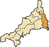
East Wivelshire
- Antony St JacobAntony, CornwallAntony is a coastal civil parish and a village in Cornwall, England, United Kingdom.The village is situated on the Rame Peninsula about three miles west of Torpoint and has a shop, a pub and a garage....
, Botus Fleming, Callington, CalstockCalstockCalstock is civil parish and a large village in south east Cornwall, England, United Kingdom, on the border with Devon. The village is situated on the River Tamar south west of Tavistock and north of Plymouth....
, EgloskerryEgloskerryEgloskerry is a village and civil parish in east Cornwall, United Kingdom. It is situated approximately five miles northwest of Launceston....
, LandulphLandulphLandulph is a hamlet and a rural civil parish in south-east Cornwall, United Kingdom. It is situated about 3 miles north of Saltash in the St Germans Registration District....
, LandrakeLandrakeLandrake is a village in southeast Cornwall, United Kingdom. It is situated approximately three miles west of Saltash in the civil parish of Landrake with St Erney...
[with St Erney], LaneastLaneastLaneast is a village and civil parish in Cornwall, United Kingdom. It is situated above the River Inny valley approximately six miles west of Launceston. The population in the 2001 census was 164.-Geography:...
, Launceston St Mary Magdalene, LawhittonLawhittonLawhitton is a civil parish and village in east Cornwall, United Kingdom. The village is situated two miles southwest of Launceston and half-a-mile west of Cornwall's border with Devon at the River Tamar....
, LewannickLewannickLewannick is a civil parish and village in Cornwall, United Kingdom. The village is situated approximately five miles southwest of Launceston. The civil parish has a population of 884....
, LezantLezantLezant is a civil parish and village in east Cornwall, United Kingdom. Lezant village is situated approximately five miles south of Launceston. The population of the parish in the 2001 census was 751.-Geography:...
, LinkinhorneLinkinhorneLinkinhorne is a civil parish and village in southeast Cornwall, United Kingdom. The village itself is situated at and is approximately four miles northwest of Callington and seven miles south of Launceston.-History and geography:As well as Linkinhorne itself, other settlements in the parish...
, MakerMakerMaker is a village between Cawsand and Rame Head, situated on the Rame Peninsula, in Cornwall, United Kingdom.The name means a ruin in Cornish, but another Celtic name is Egloshayle, which means, the church on the estuary, a very apt description of the church's location.The village and its...
, St MellionSt MellionSt Mellion is a village and rural civil parish in east Cornwall, United Kingdom. The parish is three miles south of Callington and is in the St Germans Registration District. The population in the 2001 census was 377...
, MenheniotMenheniotMenheniot is a civil parish and village in Cornwall, United Kingdom. The village is situated 2½ miles southeast of Liskeard. The meaning of the name is "sanctuary of Neot" ....
, North HillNorth Hill, CornwallNorth Hill is a civil parish and village in Cornwall, United Kingdom. The village is situated on the east side of the River Lynher approximately six miles southwest of Launceston....
, PillatonPillatonFor the village in Staffordshire, see Pillaton, StaffordshirePillaton is a village and civil parish in south east Cornwall, England, United Kingdom....
, QuethiockQuethiockQuethiock is a village and civil parish in Cornwall, United Kingdom, roughly five miles east of Liskeard. According to the 2001 census the parish had a population of 429. The ancient parish church of St Hugh is one of the most notable in Cornwall. The placename derives from the Old Cornish cuidoc...
, Rame, SheviockSheviockSheviock is a coastal civil parish and a hamlet in south-east Cornwall, United Kingdom. The parish is two miles south of St Germans and three miles south-west of Saltash....
, South HillSouth Hill, CornwallSouth Hill is a civil parish and village in east Cornwall, United Kingdom.The parish church was consecrated in 1333 and apart from the upper stage of the tower and the south aisle is entirely of this date...
, South PetherwinSouth PetherwinSouth Petherwin is a village and civil parish in east Cornwall, United Kingdom. It is in the Registration District of Launceston. The civil parish is bounded to the north by the Launceston parishes of St Thomas and St Mary Magdalene, to the east by Lawhitton and Lezant parishes and to the west by...
, St Germans, St JohnSt John, CornwallSt John is a coastal civil parish and a village in south-east Cornwall, United Kingdom south of Saltash and south-east of Torpoint.-Geography:...
, St Stephens-with-NewportSt Stephen-by-LauncestonSt Stephens by Launceston Rural is a civil parish in the east of Cornwall, United Kingdom. It is in the Registration district of Launceston. The population of the parish in the 2001 census was 312...
, Stoke ClimslandStoke ClimslandStoke Climsland is a village in the River Tamar Valley, Cornwall, United Kingdom within the civil parish of Stokeclimsland.The manor of Climsland was one of the 17 Antiqua maneria of the Duchy of Cornwall.-Notable buildings:...
, St Dominick, St IveSt IveSt Ive is a village and civil parish in south-east Cornwall, England, United Kingdom. St Ive should not be confused with St Ives, the well-known seaside town in the west of Cornwall...
, St Stephen-by-SaltashSaltashSaltash is a town and civil parish in Cornwall, England, United Kingdom. It has a population of 14,964. It lies in the south east of Cornwall, facing Plymouth over the River Tamar. It was in the Caradon district until March 2009 and is known as "the gateway to Cornwall". Saltash means ash tree by...
, St Thomas Apostle-by-Launceston, TorpointTorpointTorpoint is a civil parish and town on the Rame Peninsula in southeast Cornwall, England, United Kingdom. It is situated opposite the city of Plymouth across the Hamoaze which is the tidal estuary of the River Tamar....
, TremaineTremaine, CornwallTremaine is a small village and a rural civil parish in east Cornwall, United Kingdom. It is in the Registration District of Launceston and the population in the 2001 census was 87....
, TresmeerTresmeerTresmeer is a hamlet and a civil parish in north-east Cornwall, United Kingdom. The hamlet is situated approximately seven miles north-west of Launceston....
, TrewenTrewenTrewen is a hamlet and a civil parish in east Cornwall, United Kingdom. The parish is just east of Bodmin Moor in the River Inny valley and lies in the Registration District of Launceston....
West Wivelshire
- BoconnocBoconnocBoconnoc is a civil parish in Cornwall, United Kingdom, approximately four miles east of Lostwithiel. According to the 2001 census the parish had a population of 121.The parish is rural in character and is fairly well wooded...
, BraddockBraddock, CornwallBraddock is a village and a civil parish in Cornwall, England, United Kingdom. The village is situated about seven miles west of Liskeard, and five miles south-east of Bodmin....
[Broadoak], CardinhamCardinhamCardinham is a civil parish and a village in central Cornwall, United Kingdom. The village is situated approximately three-and-a-half miles , east-northeast of Bodmin....
, St CleerSt CleerSt Cleer is a civil parish and village in Cornwall, United Kingdom. The village is situated on the southeast flank of Bodmin Moor approximately two miles north of Liskeard....
, DuloeDuloe, CornwallDuloe is a village and civil parish in Cornwall, United Kingdom. It is situated approximately four miles south of Liskeard at .-Parish church:...
, St KeyneSt KeyneSt Keyne is a civil parish and village in Cornwall, United Kingdom. The parish lies between the parishes of Liskeard and Duloe.In Victorian times the holywell in St Keyne had the reputation of conferring supremacy to the marriage partner who first tasted it.The church is dedicated to Saint Keyne...
, LanreathLanreathLanreath is a civil parish and a village in southeast Cornwall, United Kingdom. The village is situated five miles west-northwest of Looe. The name Lanreath means 'church of Raydhogh' and it has been known variously as Lanreythow, Lanrathew, or Lanrethou...
, LansallosLansallosLansallos is a coastal hamlet and a civil parish in south Cornwall, United Kingdom. It is situated between Polruan and Polperro about 5 miles east of Fowey and is in the Liskeard Registration District....
, Lanteglos by Fowey, LiskeardLiskeardLiskeard is an ancient stannary and market town and civil parish in south east Cornwall, England, United Kingdom.Liskeard is situated approximately 20 miles west of Plymouth, west of the River Tamar and the border with Devon, and 12 miles east of Bodmin...
, St Martin-by-LooeSt Martin-by-LooeSt Martin-by-Looe is a coastal civil parish in south Cornwall, United Kingdom. The parish is immediately east of the town and parish of Looe, seven miles south of Liskeard...
, MorvalMorval, CornwallMorval is a rural civil parish and hamlet in south Cornwall, United Kingdom. The hamlet is approximately two miles north of Looe and five miles south of Liskeard....
, St Neot, PelyntPelyntPelynt is a civil parish and village in Cornwall, United Kingdom. It is situated 20 miles west of Plymouth and four miles west-northwest of Looe. Pelynt has a population of around 1,124 ....
, St PinnockSt PinnockSt Pinnock is a hamlet and civil parish in south-east Cornwall, United Kingdom. The parish is in the Liskeard Registration District and the population in the 2001 census was 621....
, TallandTallandTalland is a hamlet and ecclesiastical parish situated between Looe and Polperro on the south coast of Cornwall...
, St VeepSt VeepSt. Veep is a civil parish in Cornwall, United Kingdom situated above the east bank of the Fowey Estuary about three miles southeast of Lostwithiel....
, WarlegganWarlegganWarleggan is a civil parish on the southern edge of Bodmin Moor in Cornwall, England, United Kingdom.The parish is roughly oblong in shape with hamlets near the church and at Mount. The River Warleggan, a tributary of the River Fowey, runs through the parish, forming its western boundary in places...
, St WinnowSt WinnowSt Winnow is a civil parish situated in Cornwall, England, UK. Its name may be connected with either that of Saint Winnoc or Saint Winwaloe. It has a population of 304....
Scilly
- St AgnesSt. Agnes, Isles of ScillySt Agnes is the southernmost populated island of the Isles of Scilly, England, United Kingdom.-Description:St. Agnes joins the island of Gugh by a tombolo, a kind of sandbar, called the Gugh Bar, which is exposed only at low tide...
, St Mary'sSt. Mary's, Isles of ScillySt Mary's is the largest island of the Isles of Scilly, an archipelago off the southwest coast of Cornwall in the United Kingdom.-Description:...
, St Martin'sSt Martin's, Isles of ScillySt Martin's is the northernmost populated island of the Isles of Scilly, United Kingdom. It has an area of .-Description:There are three main settlements on the island - Higher Town, Middle Town and Lower Town - in addition to a number of scattered farms and cottages, with a total population of...
, BryherBryher, Isles of ScillyBryher is the smallest of the five inhabited islands of the Isles of Scilly. It is home to a population of 83 . Bryher has an area of .-Geography:...
, Tresco, SamsonSamson, Isles of ScillySamson is the largest uninhabited island of the Isles of Scilly. It is in size. The island consists of two hills, North Hill and South Hill, which are connected by an isthmus on which the former inhabitants built many of their sturdy stone cottages...
.