

Breage, Cornwall
Encyclopedia
Cornwall
Cornwall is a unitary authority and ceremonial county of England, within the United Kingdom. It is bordered to the north and west by the Celtic Sea, to the south by the English Channel, and to the east by the county of Devon, over the River Tamar. Cornwall has a population of , and covers an area of...
, England
England
England is a country that is part of the United Kingdom. It shares land borders with Scotland to the north and Wales to the west; the Irish Sea is to the north west, the Celtic Sea to the south west, with the North Sea to the east and the English Channel to the south separating it from continental...
, United Kingdom
United Kingdom
The United Kingdom of Great Britain and Northern IrelandIn the United Kingdom and Dependencies, other languages have been officially recognised as legitimate autochthonous languages under the European Charter for Regional or Minority Languages...
. The village is situated three miles (5 km) west of Helston
Helston
Helston is a town and civil parish in Cornwall, England, United Kingdom. It is situated at the northern end of the Lizard Peninsula approximately 12 miles east of Penzance and nine miles southwest of Falmouth. Helston is the most southerly town in the UK and is around further south than...
.
Other settlements in the parish include the villages of Ashton, Carleen (in Cornish
Cornish language
Cornish is a Brythonic Celtic language and a recognised minority language of the United Kingdom. Along with Welsh and Breton, it is directly descended from the ancient British language spoken throughout much of Britain before the English language came to dominate...
Carleen means Stony Fort), and Godolphin Cross
Godolphin Cross
Godolphin Cross is a village in the former Kerrier District of west Cornwall, United Kingdom. It is located in the parish of Breage approximately midway between the towns of Hayle and Helston....
; the coastal village of Praa Sands
Praa Sands
Praa Sands is a coastal village in the Parish of Breage, located off the main road between Helston and Penzance in Cornwall, England, UK...
; and the Great Work mine.
Breage is named after Saint
Saint
A saint is a holy person. In various religions, saints are people who are believed to have exceptional holiness.In Christian usage, "saint" refers to any believer who is "in Christ", and in whom Christ dwells, whether in heaven or in earth...
Breaca
Breage
Breage, also known as Breaca, Briac, etc., is a saint venerated in Cornwall and southwestern Britain. According to her late hagiography, she was an Irish nun of the 5th or 6th century who founded a church in Cornwall...
, a missionary from Ireland (to whom the 15th century church is dedicated) and it is in the former Kerrier
Kerrier
Kerrier was a local government district in Cornwall, England, United Kingdom. It was the most southerly district in the United Kingdom, other than the Isles of Scilly. Its council was based in Camborne ....
District. (The name Kerrier is thought by Charles Thomas
Charles Thomas (historian)
Antony Charles Thomas, CBE, FSA is a British historian and archaeologist who was Professor of Cornish Studies at Exeter University, and the first Director of the Institute of Cornish Studies, from 1971 until his retirement in 1991...
to be derived from an obsolete name (ker hyr = long fort) of Castle Pencaire on Tregonning Hill, Breage).
History
The parish was at the time of Domesday BookDomesday Book
Domesday Book , now held at The National Archives, Kew, Richmond upon Thames in South West London, is the record of the great survey of much of England and parts of Wales completed in 1086...
within the manor of Binnerton. There were 8 hides
Hide (unit)
The hide was originally an amount of land sufficient to support a household, but later in Anglo-Saxon England became a unit used in assessing land for liability to "geld", or land tax. The geld would be collected at a stated rate per hide...
of land with enough for 60 ploughs. There were 32 villagers and 25 smallholders with 15 ploughs between them. Apart from the arable land there was 2 acres (8,093.7 m²) of meadow, 2 sq leagues of pasture and half a sq league of woodland. Livestock were 45 mares, 13 cattle, 5 pigs and 60 sheep; the annual value was £10.
Geography
The geological formation known as the Tregonning-Godolphin Granite (one of five granite batholithBatholith
A batholith is a large emplacement of igneous intrusive rock that forms from cooled magma deep in the Earth's crust...
s in Cornwall) underlies the parish and the area was formerly an important source of tin and copper ore (see Geology of Cornwall
Geology of Cornwall
The Geology of Cornwall is dominated by its granite backbone, part of the Cornubian batholith, formed during the Variscan orogeny. Around this is an extensive metamorphic aureole formed in the mainly Devonian slates that make up most of the rest of the county...
). The area has evidence of habitation and mining for the past two millennia. Other than Praa Sands, the villages in the parish were tin and copper mining
Mining in Cornwall
Mining in Cornwall and Devon began in the early Bronze Age approximately 2,150 BC and ended with the South Crofty tin mine in Cornwall closing in 1998...
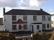
villages. Breage itself was where the mine owners (or Captains) lived as evidenced by the number of fine buildings in the village. The village water pump (presumably now disconnected) still stands today as a relic of the past. Most of today's working population are commuters, travelling to Helston, RNAS Culdrose
RNAS Culdrose
Royal Naval Air Station Culdrose , based in Cornwall, near Helston, on the Lizard Peninsula, has three major roles: serving the Fleet Air Arm's front line Sea King and Merlin helicopter squadrons; providing search and rescue for the South West region; and training specialists for the Royal Navy...
, Porthleven
Porthleven
Porthleven is a town, civil parish and fishing port in Cornwall, United Kingdom, near Helston. It is the most southerly port on the island of Great Britain and was originally developed as a harbour of refuge, when this part of the Cornish coastline was recognised as a black spot for wrecks in days...
, Penzance
Penzance
Penzance is a town, civil parish, and port in Cornwall, England, in the United Kingdom. It is the most westerly major town in Cornwall and is approximately 75 miles west of Plymouth and 300 miles west-southwest of London...
, Falmouth
Falmouth, Cornwall
Falmouth is a town, civil parish and port on the River Fal on the south coast of Cornwall, England, United Kingdom. It has a total resident population of 21,635.Falmouth is the terminus of the A39, which begins some 200 miles away in Bath, Somerset....
or even further afield. Some residents are still involved in farming or smallholding
Smallholding
A smallholding is a farm of small size.In third world countries, smallholdings are usually farms supporting a single family with a mixture of cash crops and subsistence farming. As a country becomes more affluent and farming practices become more efficient, smallholdings may persist as a legacy of...
in the surrounding area. Ashton is at : it is situated on the A394 Penzance
Penzance
Penzance is a town, civil parish, and port in Cornwall, England, in the United Kingdom. It is the most westerly major town in Cornwall and is approximately 75 miles west of Plymouth and 300 miles west-southwest of London...
-Helston
Helston
Helston is a town and civil parish in Cornwall, England, United Kingdom. It is situated at the northern end of the Lizard Peninsula approximately 12 miles east of Penzance and nine miles southwest of Falmouth. Helston is the most southerly town in the UK and is around further south than...
road one mile (1.6 km) north of Praa Sands. Ashton has a pub called the Lion and Lamb and at one time had a football team.
Tregonning Hill, to the west of the parish, was designated a Site of Special Scientific Interest
Site of Special Scientific Interest
A Site of Special Scientific Interest is a conservation designation denoting a protected area in the United Kingdom. SSSIs are the basic building block of site-based nature conservation legislation and most other legal nature/geological conservation designations in Great Britain are based upon...
(SSSI) in 1994 for its biological
Flora and fauna of Cornwall
Cornwall is the county that forms the tip of the southwestern peninsula of England; this area has a mild and warm climate regulated by the Gulf Stream...
interest. Tremearne Par SSSI and Porthcew SSSI, along the coast west of Porthleven
Porthleven
Porthleven is a town, civil parish and fishing port in Cornwall, United Kingdom, near Helston. It is the most southerly port on the island of Great Britain and was originally developed as a harbour of refuge, when this part of the Cornish coastline was recognised as a black spot for wrecks in days...
, were designated for their geological interest and are also Geological Conservation Review
Geological Conservation Review
The Geological Conservation Review is produced by the UK's Joint Nature Conservation Committee and is designed to identify those sites of national and international importance needed to show all the key scientific elements of the geological and geomorphological features of Britain...
sites.
Parish Church
The church was built of granite in the 15th century: on the north wall are five medieval wall paintings. A Roman milestone of the 3rd century is preserved in the church and in the churchyard there is an unusual Hiberno-Saxon cross head. The inscription on the milestone is: IMP [C] DO NO MARC CASSI: this incomplete text refers to the Emperor (Marcus Cassianus) PostumusPostumus
Marcus Cassianius Latinius Postumus was a Roman emperor of Batavian origin. He usurped power from Gallienus in 260 and formed the so-called Gallic Empire...
, 258-68 AD (Collingwood, RIB no. 2232).
Notable people
- Sidney GodolphinSidney Godolphin (poet)Sidney Godolphin , was an English poet, courtier and politician who sat in the House of Commons between 1628 and 1643. He died fighting in the Royalist army in the English Civil War.-Biography:...
, the Cavalier poet and courtier, was baptised in Breage. - Major-General David TyackeDavid TyackeDavid Noel Hugh Tyacke, CB, OBE, , was a senior British Army officer. His last post was as General Officer Commanding the Singapore District and he had previously been the last commanding officer of 1st Battalion, Duke of Cornwall's Light Infantry prior to amalgamation into the Somerset and...
, the last Commanding Officer of the Duke of Cornwall's Light InfantryDuke of Cornwall's Light InfantryThe Duke of Cornwall's Light Infantry was an infantry regiment of the British Army from 1881 to 1959. Its lineage is continued today by The Rifles....
was born and buried in Breage, where his family had been involved in tin-mining since the early 18th century.