
Kea, Cornwall
Encyclopedia
Kea is a civil parish and village in Cornwall
, United Kingdom
. It is a "large straggling parish" in a former mining area
south of Truro
.
Kea village is situated just over one mile (1.6 km) southwest of Truro.
Old Kea
is situated two miles (3 km) to the east on the west bank of the Truro River at . St Kea reputedly landed at Old Kea on his first visit to Cornwall and established a church there, which was the parish church until replaced by All Hallows.
Today, the parish is mainly agricultural, and is noted for giving its name to the damson-type Kea plum. It is bounded to the north by Calenick Creek and Truro civil parish; to the east by the Truro River and River Fal
; to the south by the parishes of Feock
, Perranarworthal
and Gwennap; and to the west by Kenwyn
. Other settlements in the parish include Calenick
, Come-to-Good
, Killiow, Nansavallan, Playing Place
and Porth Kea.
Kea was described in 1870-72, John Marius Wilson's Imperial Gazetteer of England and Wales
(1870) as:
. The church has a steep tiled roof and a lead spire. The font is Norman and of the Altarnun type. This present church was consecrated 4 June 1896.
The church of St Kea at Old Kea was the parish church until All Hallows was built. Later, the church at Old Kea was pulled down and only the tower remains today.. A small chapel now stands beside the ruined medieval tower and services are held there twice a month
Kea Monastery
was a monastery probably at Kea of which little is known. "The mysterious land-owning monastery of St Cheus mentioned in Domesday (in Powder), 1085, possibly refers to Kea."--Charles Henderson, in Cornish Church Guide, 1925, p. 116.
There is a school in the parish, Kea Community Primary School, which caters for 200 pupils aged between 4 and 11 years. The school stands at a crossroads half-a-mile (1 km) east of Kea village at
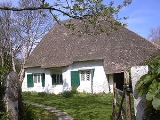
A Quaker Meeting House
opened in Come-to-Good
, Kea, in 1710.
Cornwall
Cornwall is a unitary authority and ceremonial county of England, within the United Kingdom. It is bordered to the north and west by the Celtic Sea, to the south by the English Channel, and to the east by the county of Devon, over the River Tamar. Cornwall has a population of , and covers an area of...
, United Kingdom
United Kingdom
The United Kingdom of Great Britain and Northern IrelandIn the United Kingdom and Dependencies, other languages have been officially recognised as legitimate autochthonous languages under the European Charter for Regional or Minority Languages...
. It is a "large straggling parish" in a former mining area
Mining in Cornwall
Mining in Cornwall and Devon began in the early Bronze Age approximately 2,150 BC and ended with the South Crofty tin mine in Cornwall closing in 1998...
south of Truro
Truro
Truro is a city and civil parish in Cornwall, England, United Kingdom. The city is the centre for administration, leisure and retail in Cornwall, with a population recorded in the 2001 census of 17,431. Truro urban statistical area, which includes parts of surrounding parishes, has a 2001 census...
.
Kea village is situated just over one mile (1.6 km) southwest of Truro.
Old Kea
Old Kea
Old Kea is a hamlet in Cornwall, United Kingdom. It is situated on the west bank of the Truro River approximately two miles south of Truro....
is situated two miles (3 km) to the east on the west bank of the Truro River at . St Kea reputedly landed at Old Kea on his first visit to Cornwall and established a church there, which was the parish church until replaced by All Hallows.
Today, the parish is mainly agricultural, and is noted for giving its name to the damson-type Kea plum. It is bounded to the north by Calenick Creek and Truro civil parish; to the east by the Truro River and River Fal
River Fal
The River Fal flows through Cornwall, United Kingdom, rising on the Goss Moor and reaching the English Channel at Falmouth. On or near the banks of the Fal are the castles of Pendennis and St Mawes as well as Trelissick Garden. The River Fal separates the Roseland peninsula from the rest of...
; to the south by the parishes of Feock
Feock, Cornwall
Feock is a coastal civil parish and village in Cornwall, United Kingdom. It is situated approximately 5 miles south of Truro at the head of Carrick Roads on the River Fal. To the south, the parish is bounded by Restronguet Creek and to the east by Carrick Roads and the River Fal...
, Perranarworthal
Perranarworthal
Perranarworthal is a civil parish and village in Cornwall, United Kingdom. The village is situated approximately four miles northwest of Falmouth and five miles southwest of Truro....
and Gwennap; and to the west by Kenwyn
Kenwyn
Kenwyn is a settlement and civil parish in Cornwall, United Kingdom. The settlement is a suburb of the city of Truro and is situated half-a-mile north of the city centre. It gives its name to one of three rivers that flow through the city....
. Other settlements in the parish include Calenick
Calenick
Calenick is a hamlet about a mile south of Truro in Cornwall, England, UK....
, Come-to-Good
Come-to-Good
Come-to-Good is a small settlement in Cornwall, United Kingdom.It consists of a farm, seven residential houses and a Quaker Meeting House, built in 1710. It lies on the Tregye Road between Carnon Downs and King Harry Ferry...
, Killiow, Nansavallan, Playing Place
Playing Place
Playing Place is a village southwest of Truro in Cornwall, England, UK. It is to the east of the A39 road....
and Porth Kea.
Kea was described in 1870-72, John Marius Wilson's Imperial Gazetteer of England and Wales
Imperial Gazetteer of England and Wales
The Imperial Gazetteer of England and Wales is a substantial topographical dictionary first published between 1870 and 1872, edited by the Reverend John Marius Wilson. It contains a detailed description of England and Wales...
(1870) as:
- A parish and a sub-district in Truro district, Cornwall. The parish lies on the Falmouth and Redruth railways, 2¼ miles SSW of Truro; is bounded, on the E, by the river Fal, on the N, by Kenwyn, on the W, by Gwennap; and contains parts of the chapelries of Baldhu, Chacewater, and Mithian. Real property £7,158 of which £1,234 are in mines. Pop(ulation) in 1861 3,949. Houses, 824. The manor belongs to Viscount Falmouth.
Churches and schools
All Hallows church is in Kea village at . It was built in 1895 to replace a church of 1802 which was the work of James WyattJames Wyatt
James Wyatt RA , was an English architect, a rival of Robert Adam in the neoclassical style, who far outdid Adam in his work in the neo-Gothic style.-Early classical career:...
. The church has a steep tiled roof and a lead spire. The font is Norman and of the Altarnun type. This present church was consecrated 4 June 1896.
The church of St Kea at Old Kea was the parish church until All Hallows was built. Later, the church at Old Kea was pulled down and only the tower remains today.. A small chapel now stands beside the ruined medieval tower and services are held there twice a month
Kea Monastery
Kea Monastery
Kea Monastery was a monastery at Kea in Cornwall, UK, of which little is known. "The mysterious land-owning monastery of St Cheus mentioned in Domesday , 1085, possibly refers to Kea."--Charles Henderson, in Cornish Church Guide, 1925, p...
was a monastery probably at Kea of which little is known. "The mysterious land-owning monastery of St Cheus mentioned in Domesday (in Powder), 1085, possibly refers to Kea."--Charles Henderson, in Cornish Church Guide, 1925, p. 116.
There is a school in the parish, Kea Community Primary School, which caters for 200 pupils aged between 4 and 11 years. The school stands at a crossroads half-a-mile (1 km) east of Kea village at
Houses
At Calenick and Killiow are 18th century houses of two storeys. Calenick House contains remains of a much older building; it is of seven bays and there is a separate clock tower with a cupola, dated 1752. Killiow House is somewhat later and was extended ca. 1850.A Quaker Meeting House
Friends Meeting House, Come-to-Good
The Friends Meeting House, Come-to-Good, is a meeting house of the Society of Friends, on the southern border of the Parish of Kea, near Truro in Cornwall, UK. It was also known as Kea Meeting House and Feock Meeting House....
opened in Come-to-Good
Come-to-Good
Come-to-Good is a small settlement in Cornwall, United Kingdom.It consists of a farm, seven residential houses and a Quaker Meeting House, built in 1710. It lies on the Tregye Road between Carnon Downs and King Harry Ferry...
, Kea, in 1710.