
Holston Mountain
Encyclopedia
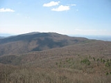
Holston Mountain is a mountain
ridge in Upper East Tennessee and southwest
Virginia
, in the United States
. It is in the Blue Ridge Mountains
part of the Appalachian Mountains
. Holston Mountain is a very prominent ridge
-type mountain in Tennessee's Ridge and Valley Region, about 28 miles (45 km) long, running from southwest to northeast, covering about 268 square miles (694 km²). Its highest summit is Holston High Point, on which a Federal Aviation Administration
(FAA) aircraft navigational beacon is located, at an elevation of 4,280 feet (1,304.5 m) above mean sea level. The second highest point is Rye Patch Knob, at 4,260 feet (1,298.5 m) above mean sea level. The third highest point is Holston High Knob where an old dismantled Cherokee National Forest
fire tower marks the elevation at 4,136 feet (1,240.5 m) above mean sea level.
; on the southeast by Stoney Creek Valley, Shady Valley, and the Iron Mountains
; on the northeast by the town of Damascus, Virginia
; and on the southwest by the community of Keenburg, near Elizabethton, Tennessee
.
The southern portion of Holston Mountain marks the boundary between Sullivan County and Carter County
; the northern portion is between Sullivan and Johnson County. The small northernmost portion extends into Washington County, Virginia
.
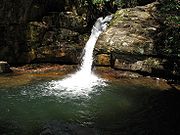 Panhandle Road is located off State Highway 91 in Carter County and ascends Holston Mountain for three miles (5 km) from the eastern side and ends four miles (6.5 km) along the ridge southwest of Holston High Point. During periods of heavy snow and ice, hunting season, or nesting season, the Tennessee Wildlife Resources Agency closes off Panhandle Road with an iron gate.
Located near the Cherokee National Forest boundary and to the left of Panhandle Road is a parking area and foot trail that leads down the slope to the Blue Hole Falls (approximately 45 feet (13.7 m) high). The iron gate referred to above is there, owned and maintained by the Cherokee National Forest, Unaka District. No matter, though.. the last three miles (5 km) of Panhandle Road along the top of the ridge are filled with washouts, steep drop-offs, and no turnarounds. Vehicle travel on those last three miles (5 km) is at the driver's risk.
U.S. Route 421
crosses Holston Mountain at Low Gap, connecting the town of Shady Valley, Tennessee
, with the city of Bristol, Tennessee
.
, which is named for Stephen Holston, a descendant of a Swede of New Sweden
. Stephen Holston moved west and in 1746 built a cabin near the headwaters of a little creek. When surveyors were working in the area the next year they gave the creek the name "Holston's Creek", because Stephen Holston lived on it. Later pioneers followed the creek downstream where, after receiving many tributaries, it was wide enough to become a river and so it became known as the Holston River. George R. Stewart
, describing this placename history, notes, "Thus one of the largest streams of that region came to bear the name of a common settler". Stewart goes on to note that the nearby Clinch River
is likewise named for a "common settler". Unlike Holston, the identity of Clinch is unknown, except that Dr. Walker
wrote of a stream called "Clinch's River, from one Clinch a hunter".
October 4, 1976 Kingsport, Tennessee Daily News staff writer, Mark Aldeen, in an article entitled “Investigation Into Cause Of Plane Crash Continues”, reported the crash landing of a USAF, reconnaissance plane on Holston Mountain, 13.2 miles from the Tri-cites airport. The RF-4C “Phantom” carried two Airmen, neither which survived.
September 1, 2007 The FAA says five Jehovah's Witnesses
ministers from East Tennessee were killed when their small plane crashed in the Cherokee National Forest on Holston Mountain shortly after takeoff. A passing airplane spotted the smoldering wreckage around 7:00 p.m. Saturday about a mile and a half down the southern side of the mountain, from the Holston High Point broadcasting antenna farm.
crosses over from Iron Mountain from the southeast side, then runs along the upper northeast end of Holston Mountain. The trail descends on the northeast end, sloping down the mountain into Virginia, the town of Damascus, and continues to Mount Rogers
, the highest point in Virginia.
and Southwest Virginia in the surrounding valley between Knoxville, Tennessee
, to southwest of Roanoke, Virginia
. As a result, the Holston Mountain ridge is the transmitting site for three television stations in the Tri-Cities, Tennessee
Television Designated Market Area (DMA). The digital broadcasting antenna for WCYB-DT, PSIP Channel 5, Bristol, Virginia is on Rye Patch Knob, with the top of the antenna 341 feet (104 m) above ground, 2,431 feet (741 m) above the surrounding valley floor, and 4,533 feet (1381.6 m) above mean sea level. The single tower that antenna sits on, is the highest and tallest man-made structure on the mountain, allowing the Virginia station to transmit from the highest broadcasting point in Tennessee, Virginia and Kentucky. The television towers for WJHL-DT, PSIP Channel 11, Johnson City, Tennessee
, and WKPT-DT, PSIP Channel 19, Kingsport, Tennessee
, are standing side by side in a common broadcasting antenna farm on the southwest slope of Holston High Point, one mile (1.5 km) southwest of Rye Patch Knob. The antenna for WJHL-DT stands 200 feet (61m) above ground, 2,319 feet (707m) above the surrounding valley floor, and 4,370 feet (1,332m) above mean sea level. The antenna for WKPT-DT next door stands 193 feet (58.8m) above ground, also 2,319 feet (707m) above the valley floor, and 4,366 feet (1,331m) above mean sea level.
According to a Federal Communications Commission
(FCC) filing, the transmitter for WEMT-DT, PSIP Channel 39, currently on Camp Creek Bald (Viking Mountain) outside Greeneville, Tennessee will be relocated to the same tower used by co-owned station WCYB-TV on Holston Mountain, some time in 2010.
Holston Mountain is also the transmitting site for three FM Class C radio stations: WTFM-FM 98.5, Kingsport, Tennessee; WXBQ-FM
96.9, Bristol, Virginia and WETS-FM
89.5, Johnson City, Tennessee. All three antennas and the backup antennas are located at the antenna farm on the southwest slope of Holston High Point. Also located on the ridge are the antenna for one FM Class C1 radio station, WHCB-FM 91.5, Bristol, Tennessee, located at Rye Patch Knob; one FM Class C2 antenna for radio station WCQR-FM 88.3, Kingsport, Tennessee, and one FM Class D antenna for radio station W214AP-FM 90.7, Johnson City, Tennessee, both transmitting from the antenna farm on the southwest slope of Holston High Point. Located further down the southwestern slope, off of Holston Mountain Road, is the transmitting site of FM Class C3 WTZR-FM
99.3, Elizabethton, Tennessee
. Various U.S. federal, Tennessee state, Sullivan, Washington and Carter County governmental agencies, along with utility microwave relay stations, also transmit base-to-mobile communications from the Holston High Point antenna farm and Rye Patch Knob.
, on which most of the FM and TV stations in the Knoxville, Tennessee
Designated Market Area (DMA) have their antennas and towers. The next nearest from Holston Mountain is on Poor Mountain
in Central Virginia
, home to most of the FM and TV stations in the Roanoke, Virginia
Radio and Television DMA. Although most radio and TV stations are in fierce competition with each other in their broadcast markets, they will often locate their broadcasting antennas very near each other, and in some cases, will even share land or towers with each other, in the interests of space, land availability, and the cost of putting a transmission building on top of a mountain. Other examples of co-located towers on mountain peaks in the United States are on Signal Mountain
near Chattanooga, Tennessee; Sharp's Ridge
in Knoxville, Tennessee; Red Mountain
in Birmingham, Alabama; Mount Wilson
near Los Angeles; Sutro Tower
in San Francisco; Lookout Mountain near Denver; Cedar Hill between Dallas and Fort Worth; South Mountain Park
near Phoenix; Nelson Peak near Salt Lake City, Sandia Crest near Albuquerque, New Mexico, and probably the most famous broadcast antenna farm of all: The World Trade Center
Tower One, on which all of the New York City television and FM stations had their antennas. All were lost when Twin Towers One and Two collapsed after a terrorist attack on September 11, 2001. All the New York City stations now broadcast from their old home, 200 feet lower, on the Empire State Building
.
Mountain
Image:Himalaya_annotated.jpg|thumb|right|The Himalayan mountain range with Mount Everestrect 58 14 160 49 Chomo Lonzorect 200 28 335 52 Makalurect 378 24 566 45 Mount Everestrect 188 581 920 656 Tibetan Plateaurect 250 406 340 427 Rong River...
ridge in Upper East Tennessee and southwest
Southwest Virginia
Southwest Virginia, often abbreviated as SWVA, is a mountainous region of Virginia in the westernmost part of the commonwealth. Southwest Virginia has been defined alternatively as all Virginia counties on the Appalachian Plateau, all Virginia counties west of the Eastern Continental Divide, or...
Virginia
Virginia
The Commonwealth of Virginia , is a U.S. state on the Atlantic Coast of the Southern United States. Virginia is nicknamed the "Old Dominion" and sometimes the "Mother of Presidents" after the eight U.S. presidents born there...
, in the United States
United States
The United States of America is a federal constitutional republic comprising fifty states and a federal district...
. It is in the Blue Ridge Mountains
Blue Ridge Mountains
The Blue Ridge Mountains are a physiographic province of the larger Appalachian Mountains range. This province consists of northern and southern physiographic regions, which divide near the Roanoke River gap. The mountain range is located in the eastern United States, starting at its southern-most...
part of the Appalachian Mountains
Appalachian Mountains
The Appalachian Mountains #Whether the stressed vowel is or ,#Whether the "ch" is pronounced as a fricative or an affricate , and#Whether the final vowel is the monophthong or the diphthong .), often called the Appalachians, are a system of mountains in eastern North America. The Appalachians...
. Holston Mountain is a very prominent ridge
Ridge
A ridge is a geological feature consisting of a chain of mountains or hills that form a continuous elevated crest for some distance. Ridges are usually termed hills or mountains as well, depending on size. There are several main types of ridges:...
-type mountain in Tennessee's Ridge and Valley Region, about 28 miles (45 km) long, running from southwest to northeast, covering about 268 square miles (694 km²). Its highest summit is Holston High Point, on which a Federal Aviation Administration
Federal Aviation Administration
The Federal Aviation Administration is the national aviation authority of the United States. An agency of the United States Department of Transportation, it has authority to regulate and oversee all aspects of civil aviation in the U.S...
(FAA) aircraft navigational beacon is located, at an elevation of 4,280 feet (1,304.5 m) above mean sea level. The second highest point is Rye Patch Knob, at 4,260 feet (1,298.5 m) above mean sea level. The third highest point is Holston High Knob where an old dismantled Cherokee National Forest
Cherokee National Forest
The Cherokee National Forest is a large National Forest created on July 19, 1936, by U.S. President Franklin Roosevelt, operated by the U.S. Forest Service and encompassing some 640,000 acres .-Location:...
fire tower marks the elevation at 4,136 feet (1,240.5 m) above mean sea level.
Geography
Holston Mountain is located in Cherokee National Forest. It is bounded on the northwest by South Holston LakeSouth Holston Lake
South Holston Lake is located near the cities of Abingdon, Virginia and Bristol, Virginia / Bristol, Tennessee, and is a impoundment operated by the Tennessee Valley Authority . Much of the reservoir is in Tennessee, but the Virginia portion of the reservoir offers anglers more than of water...
; on the southeast by Stoney Creek Valley, Shady Valley, and the Iron Mountains
Iron Mountains
The Iron Mountains are a minor range of the Appalachian Mountains. These mountains are located around the common meeting point of Tennessee, Virginia, and North Carolina...
; on the northeast by the town of Damascus, Virginia
Damascus, Virginia
Damascus is a town in Washington County, Virginia, United States. The population was 981 at the 2000 census. It is part of the Kingsport–Bristol –Bristol Metropolitan Statistical Area, which is a component of the Johnson City–Kingsport–Bristol, TN-VA Combined Statistical...
; and on the southwest by the community of Keenburg, near Elizabethton, Tennessee
Elizabethton, Tennessee
Elizabethton is the county seat of Carter County, Tennessee, United States. Elizabethton is also the historical site both of the first independent American government located west of both the Eastern Continental Divide and the original thirteen British American colonies.Elizabethton is also the...
.
The southern portion of Holston Mountain marks the boundary between Sullivan County and Carter County
Carter County, Tennessee
Carter County is a county located in the U.S. state of Tennessee. As of 2010, the population was 57,424. Its county seat is Elizabethton.Carter County is part of the Johnson City Metropolitan Statistical Area, which is a component of the Johnson City–Kingsport–Bristol, TN-VA Combined...
; the northern portion is between Sullivan and Johnson County. The small northernmost portion extends into Washington County, Virginia
Washington County, Virginia
As of the census of 2000, there were 51,103 people, 21,056 households, and 14,949 families residing in the county. The population density was 91 people per square mile . There were 22,985 housing units at an average density of 41 per square mile...
.
Located near the Cherokee National Forest boundary and to the left of Panhandle Road is a parking area and foot trail that leads down the slope to the Blue Hole Falls (approximately 45 feet (13.7 m) high). The iron gate referred to above is there, owned and maintained by the Cherokee National Forest, Unaka District. No matter, though.. the last three miles (5 km) of Panhandle Road along the top of the ridge are filled with washouts, steep drop-offs, and no turnarounds. Vehicle travel on those last three miles (5 km) is at the driver's risk.
U.S. Route 421
U.S. Route 421
U.S. Route 421 is a spur route of U.S. 21. It runs for from Michigan City, Indiana, at U.S. 20, to Fort Fisher in North Carolina. The highway goes through the cities of Indianapolis, Indiana, Lexington, Kentucky, Boone, North Carolina, Winston-Salem, North Carolina, Greensboro, North Carolina and...
crosses Holston Mountain at Low Gap, connecting the town of Shady Valley, Tennessee
Shady Valley, Tennessee
Shady Valley is an unincorporated community in Johnson County in the northeastern corner of the U.S. state of Tennessee. It is just outside of Cherokee National Forest. Shady Valley is also the name of the valley in which the town is located.-Natural history:...
, with the city of Bristol, Tennessee
Bristol, Tennessee
Bristol is a city in Sullivan County, Tennessee, United States. The population was 26,702 at the 2010 census. It is the twin city of Bristol, Virginia, which lies directly across the state line between Tennessee and Virginia. The boundaries of both cities run parallel to each other along State...
.
History
Holston Mountain is named after the Holston RiverHolston River
The Holston River is a major river system of southwestern Virginia and east Tennessee. The three major forks of the Holston rise in southwestern Virginia and have their confluence near Kingsport, Tennessee. The North Fork flows southwest from Sharon Springs in Bland County, Virginia...
, which is named for Stephen Holston, a descendant of a Swede of New Sweden
New Sweden
New Sweden was a Swedish colony along the Delaware River on the Mid-Atlantic coast of North America from 1638 to 1655. Fort Christina, now in Wilmington, Delaware, was the first settlement. New Sweden included parts of the present-day American states of Delaware, New Jersey, and Pennsylvania....
. Stephen Holston moved west and in 1746 built a cabin near the headwaters of a little creek. When surveyors were working in the area the next year they gave the creek the name "Holston's Creek", because Stephen Holston lived on it. Later pioneers followed the creek downstream where, after receiving many tributaries, it was wide enough to become a river and so it became known as the Holston River. George R. Stewart
George R. Stewart
George Rippey Stewart was an American toponymist, a novelist, and a professor of English at the University of California, Berkeley...
, describing this placename history, notes, "Thus one of the largest streams of that region came to bear the name of a common settler". Stewart goes on to note that the nearby Clinch River
Clinch River
The Clinch River rises in Southwest Virginia near Tazewell, Virginia and flows southwest through the Great Appalachian Valley, gathering various tributaries including the Powell River before joining the Tennessee River in East Tennessee.-Course:...
is likewise named for a "common settler". Unlike Holston, the identity of Clinch is unknown, except that Dr. Walker
Thomas Walker (explorer)
Dr. Thomas Walker was a physician and explorer from Virginia who led an expedition to what is now the region beyond the Allegheny Mountains area of British North America in the mid-18th century...
wrote of a stream called "Clinch's River, from one Clinch a hunter".
October 4, 1976 Kingsport, Tennessee Daily News staff writer, Mark Aldeen, in an article entitled “Investigation Into Cause Of Plane Crash Continues”, reported the crash landing of a USAF, reconnaissance plane on Holston Mountain, 13.2 miles from the Tri-cites airport. The RF-4C “Phantom” carried two Airmen, neither which survived.
September 1, 2007 The FAA says five Jehovah's Witnesses
Jehovah's Witnesses
Jehovah's Witnesses is a millenarian restorationist Christian denomination with nontrinitarian beliefs distinct from mainstream Christianity. The religion reports worldwide membership of over 7 million adherents involved in evangelism, convention attendance of over 12 million, and annual...
ministers from East Tennessee were killed when their small plane crashed in the Cherokee National Forest on Holston Mountain shortly after takeoff. A passing airplane spotted the smoldering wreckage around 7:00 p.m. Saturday about a mile and a half down the southern side of the mountain, from the Holston High Point broadcasting antenna farm.
Trails
The Appalachian TrailAppalachian Trail
The Appalachian National Scenic Trail, generally known as the Appalachian Trail or simply the AT, is a marked hiking trail in the eastern United States extending between Springer Mountain in Georgia and Mount Katahdin in Maine. It is approximately long...
crosses over from Iron Mountain from the southeast side, then runs along the upper northeast end of Holston Mountain. The trail descends on the northeast end, sloping down the mountain into Virginia, the town of Damascus, and continues to Mount Rogers
Mount Rogers
Mount Rogers is the highest natural point in the state of Virginia, USA, with a summit elevation of above mean sea level. It lies in Grayson County and Smyth County, Virginia, about WSW of Troutdale, Virginia, within the Mount Rogers National Recreation Area and Jefferson National Forest.The...
, the highest point in Virginia.
Communications Hub
Early broadcasters in the 1950s and 1960s quickly realized Holston Mountain as a prime radio-television transmission location because it is the highest visible point that faces most of the major cities in Upper East TennesseeEast Tennessee
East Tennessee is a name given to approximately the eastern third of the U.S. state of Tennessee, one of the three Grand Divisions of Tennessee defined in state law. East Tennessee consists of 33 counties, 30 located within the Eastern Time Zone and three counties in the Central Time Zone, namely...
and Southwest Virginia in the surrounding valley between Knoxville, Tennessee
Knoxville, Tennessee
Founded in 1786, Knoxville is the third-largest city in the U.S. state of Tennessee, U.S.A., behind Memphis and Nashville, and is the county seat of Knox County. It is the largest city in East Tennessee, and the second-largest city in the Appalachia region...
, to southwest of Roanoke, Virginia
Roanoke, Virginia
Roanoke is an independent city in the Mid-Atlantic U.S. state of Virginia and is the tenth-largest city in the Commonwealth. It is located in the Roanoke Valley of the Roanoke Region of Virginia. The population within the city limits was 97,032 as of 2010...
. As a result, the Holston Mountain ridge is the transmitting site for three television stations in the Tri-Cities, Tennessee
Tri-Cities, Tennessee
In Tennessee and Virginia the name "Tri-Cities" refers to the region comprising the cities of Kingsport, Johnson City and Bristol and the surrounding smaller towns and communities in Northeast Tennessee and Southwest Virginia...
Television Designated Market Area (DMA). The digital broadcasting antenna for WCYB-DT, PSIP Channel 5, Bristol, Virginia is on Rye Patch Knob, with the top of the antenna 341 feet (104 m) above ground, 2,431 feet (741 m) above the surrounding valley floor, and 4,533 feet (1381.6 m) above mean sea level. The single tower that antenna sits on, is the highest and tallest man-made structure on the mountain, allowing the Virginia station to transmit from the highest broadcasting point in Tennessee, Virginia and Kentucky. The television towers for WJHL-DT, PSIP Channel 11, Johnson City, Tennessee
Johnson City, Tennessee
Johnson City is a city in Carter, Sullivan, and Washington counties in the U.S. state of Tennessee, with most of the city being in Washington County...
, and WKPT-DT, PSIP Channel 19, Kingsport, Tennessee
Kingsport, Tennessee
Kingsport is a city located mainly in Sullivan County with some western portions in Hawkins County in the US state of Tennessee. The majority of the city lies in Sullivan County...
, are standing side by side in a common broadcasting antenna farm on the southwest slope of Holston High Point, one mile (1.5 km) southwest of Rye Patch Knob. The antenna for WJHL-DT stands 200 feet (61m) above ground, 2,319 feet (707m) above the surrounding valley floor, and 4,370 feet (1,332m) above mean sea level. The antenna for WKPT-DT next door stands 193 feet (58.8m) above ground, also 2,319 feet (707m) above the valley floor, and 4,366 feet (1,331m) above mean sea level.
According to a Federal Communications Commission
Federal Communications Commission
The Federal Communications Commission is an independent agency of the United States government, created, Congressional statute , and with the majority of its commissioners appointed by the current President. The FCC works towards six goals in the areas of broadband, competition, the spectrum, the...
(FCC) filing, the transmitter for WEMT-DT, PSIP Channel 39, currently on Camp Creek Bald (Viking Mountain) outside Greeneville, Tennessee will be relocated to the same tower used by co-owned station WCYB-TV on Holston Mountain, some time in 2010.
Holston Mountain is also the transmitting site for three FM Class C radio stations: WTFM-FM 98.5, Kingsport, Tennessee; WXBQ-FM
WXBQ-FM
WXBQ-FM is a Country formatted broadcast radio station licensed to Bristol, Virginia, serving the Tri-Cities. WXBQ-FM is owned and operated by Bristol Broadcasting Company, Inc.-Ratings:...
96.9, Bristol, Virginia and WETS-FM
WETS-FM
WETS-FM is the National Public Radio member station for the Tri-Cities region of northeast Tennessee and southwest Virginia. The station is operated by East Tennessee State University as a partnership between ETSU and the station’s listeners. WETS receives a little over half of its funding from...
89.5, Johnson City, Tennessee. All three antennas and the backup antennas are located at the antenna farm on the southwest slope of Holston High Point. Also located on the ridge are the antenna for one FM Class C1 radio station, WHCB-FM 91.5, Bristol, Tennessee, located at Rye Patch Knob; one FM Class C2 antenna for radio station WCQR-FM 88.3, Kingsport, Tennessee, and one FM Class D antenna for radio station W214AP-FM 90.7, Johnson City, Tennessee, both transmitting from the antenna farm on the southwest slope of Holston High Point. Located further down the southwestern slope, off of Holston Mountain Road, is the transmitting site of FM Class C3 WTZR-FM
WTZR-FM
WTZR is located in the Tri-Cities, TN area and broadcasts at 99.3 FM. Known as "Z-Rock 99.3," it is a modern rock music station with the slogan "Tri-Cities New Alternative Rock."...
99.3, Elizabethton, Tennessee
Elizabethton, Tennessee
Elizabethton is the county seat of Carter County, Tennessee, United States. Elizabethton is also the historical site both of the first independent American government located west of both the Eastern Continental Divide and the original thirteen British American colonies.Elizabethton is also the...
. Various U.S. federal, Tennessee state, Sullivan, Washington and Carter County governmental agencies, along with utility microwave relay stations, also transmit base-to-mobile communications from the Holston High Point antenna farm and Rye Patch Knob.
Antenna farms
The Holston Mountain collection of broadcast towers, commonly referred to as an "antenna farm" is a good example of radio and TV station owners, co-locating their broadcast towers near each other on the highest point near their FCC city of license. This marketing practice was borne during the 1950s, before cable and during a time when all homes had outside antennae to receive broadcast signals. When the viewer wanted to receive a clear picture or FM stereo from their favorite station, they would point their antennae toward that radio or TV station's broadcasting tower (usually on the highest mountain peak nearby). Other station owners realized the benefit of locating their transmitting towers near that one, to allow viewers to get clear signals from their stations, too. The nearest antenna farm to Holston Mountain is southwest to Sharp's RidgeSharp's Ridge
Sharp's Ridge is a steep limestone ridge in Knoxville, Tennessee, north of the city's downtown. A area of the ridge is maintained as Sharp's Ridge Memorial Park, a city park dedicated to the honor of the area's war dead. The ridge also is the site of a transmitting antenna farm that serves most...
, on which most of the FM and TV stations in the Knoxville, Tennessee
Knoxville, Tennessee
Founded in 1786, Knoxville is the third-largest city in the U.S. state of Tennessee, U.S.A., behind Memphis and Nashville, and is the county seat of Knox County. It is the largest city in East Tennessee, and the second-largest city in the Appalachia region...
Designated Market Area (DMA) have their antennas and towers. The next nearest from Holston Mountain is on Poor Mountain
Poor Mountain
Poor Mountain is a ridge of high peaks located in Roanoke County, Virginia and Montgomery County, Virginia. At 3,928 feet, Poor Mountain is the tallest mountain in the immediate area. The mountain is under consideration for the placement of a wind farm...
in Central Virginia
Virginia
The Commonwealth of Virginia , is a U.S. state on the Atlantic Coast of the Southern United States. Virginia is nicknamed the "Old Dominion" and sometimes the "Mother of Presidents" after the eight U.S. presidents born there...
, home to most of the FM and TV stations in the Roanoke, Virginia
Roanoke, Virginia
Roanoke is an independent city in the Mid-Atlantic U.S. state of Virginia and is the tenth-largest city in the Commonwealth. It is located in the Roanoke Valley of the Roanoke Region of Virginia. The population within the city limits was 97,032 as of 2010...
Radio and Television DMA. Although most radio and TV stations are in fierce competition with each other in their broadcast markets, they will often locate their broadcasting antennas very near each other, and in some cases, will even share land or towers with each other, in the interests of space, land availability, and the cost of putting a transmission building on top of a mountain. Other examples of co-located towers on mountain peaks in the United States are on Signal Mountain
Signal Mountain
Signal Mountain may refer to:*Signal Mountain, Tennessee, a town in Hamilton County, Tennessee**Because of the proximity of this town to it, Walden Ridge is often mistakenly called Signal Mountain....
near Chattanooga, Tennessee; Sharp's Ridge
Sharp's Ridge
Sharp's Ridge is a steep limestone ridge in Knoxville, Tennessee, north of the city's downtown. A area of the ridge is maintained as Sharp's Ridge Memorial Park, a city park dedicated to the honor of the area's war dead. The ridge also is the site of a transmitting antenna farm that serves most...
in Knoxville, Tennessee; Red Mountain
Red Mountain
-Canada:* Red Mountain , a mountain near Rossland, British Columbia** Red Mountain Resort, a ski resort on Red Mountain in Rossland, also known as Red Resort* Mount Price, a volcano in British Columbia, Canada formerly known as Red Mountain...
in Birmingham, Alabama; Mount Wilson
Mount Wilson
Mount Wilson can refer to several things:* Mount Wilson ** Mount Wilson Observatory* Mount Wilson, New South Wales, a mountain with a small hamlet in Australia* One of a list of peaks named Mount Wilson...
near Los Angeles; Sutro Tower
Sutro Tower
Sutro Tower is a three-pronged antenna tower near Clarendon Heights in San Francisco, California. Rising from a hill between Twin Peaks and Mount Sutro, it is a prominent part of the city skyline and a landmark for city residents and visitors...
in San Francisco; Lookout Mountain near Denver; Cedar Hill between Dallas and Fort Worth; South Mountain Park
South Mountain Park
South Mountain Park in Phoenix, Arizona, is the largest city park in the United States, one of the largest urban parks in North America and in the world. It has been designated as a Phoenix Point of Pride.-Geography and Ecology:...
near Phoenix; Nelson Peak near Salt Lake City, Sandia Crest near Albuquerque, New Mexico, and probably the most famous broadcast antenna farm of all: The World Trade Center
World Trade Center
The original World Trade Center was a complex with seven buildings featuring landmark twin towers in Lower Manhattan, New York City, United States. The complex opened on April 4, 1973, and was destroyed in 2001 during the September 11 attacks. The site is currently being rebuilt with five new...
Tower One, on which all of the New York City television and FM stations had their antennas. All were lost when Twin Towers One and Two collapsed after a terrorist attack on September 11, 2001. All the New York City stations now broadcast from their old home, 200 feet lower, on the Empire State Building
Empire State Building
The Empire State Building is a 102-story landmark skyscraper and American cultural icon in New York City at the intersection of Fifth Avenue and West 34th Street. It has a roof height of 1,250 feet , and with its antenna spire included, it stands a total of 1,454 ft high. Its name is derived...
.