
Hardangervidda National Park
Encyclopedia
Hardangervidda National Park, at 3,422 square kilometers, is Norway's largest national park
. It spans from Numedal
and Uvdal
in the east and Røvelseggi and Ullensvang
in the west across the Hardanger
mountain plateau (Hardangervidda
). Designated as a national park
in 1981, today it serves as a popular tourist destination for activities such as hiking
, climbing
, fishing
, and cross-country skiing
. The Norwegian Mountain Touring Association
(DNT) maintains a comprehensive network of huts and paths across Hardangervidda
. The Bergensbanen
railway line and the main Highway 7 cross the plateau.
It has the southernmost stock of several arctic animals and plants. Its wild reindeer
herds are among the largest in the world.
Several hundred nomadic stone age settlements have been found in the area, most likely related to the migration of the reindeer. Ancient trails cross the plateau, linking western and eastern Norway; one example is the Nordmannsslepa linking Eidfjord
and Veggli
in the Numedal
valley with Hol
and Uvdal
.
The name Hardangervidda is put together by the name of the district Hardanger
and the finite form of vidde, 'wide plain, large mountain plateau'.
 The plateau is the largest peneplain
(eroded plain) in Europe
, covering an area of about 6500 km² (2,509.7 sq mi) at an average elevation of 1,100 m (3,500 ft). The highest point on the plateau is at the top of the Hardangerjøkulen
glacier, which reaches a height of 1863 m (6,112 ft).
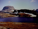
The landscape of the Hardangervidda is characterised by barren, treeless moorland interrupted by numerous pools, lakes, rivers and streams. There are significant differences between the west side, which is dominated by rocky terrain and expanses of bare rock, and the east side, which is much flatter and more heavily vegetated. The climate also varies between the two sides: it is considerably wetter on the west side than on the east, with over 1,000 mm per year (39 inches) recorded in some parts. The prominent peak of Hårteigen
1690 m (5,545 ft) is visible across much of the plateau.
Much of the Hardangervidda's geology is extremely ancient. The rolling fells of the Hardangervidda are the remnants of mountains that were worn down by the action of glaciers during the Ice Ages. The bedrock is mainly of Precambrian
and Cambro
-Silurian
origin.
animals and plants further south than anywhere else in Europe. Its wild reindeer
herds are among the largest in the world, with some 15,000 animals recorded in 1996 and around 8,000 in 2008. They migrate across the plateau during the year, moving from their winter grazing lands on the east side of the Hardangervidda, where they graze on lichen
, to their breeding grounds in the more fertile west of the plateau.
The varying climate of the plateau has a marked effect on the flora, which is richer on the wetter west side than in the drier east; much of the plateau is covered by coarse grass
es, moss
es (especially sphagnum
) and lichens.
In the Holocene climatic optimum
(stone age
) 9000 - 5000 years ago, the regional climate was warmer, and large parts of Hardangervidda were wooded; pine
logs can still be found preserved in bogs well above today's treeline. With the predicted warming
, Hardangervidda could again be largely wooded ().
(Nature Centre) in Eidfjord
, and the Hardangervidda Nasjonalparksenter (National Park Centre) in Tinn
(temporarily closed, expected reopening 2010/2011) at Skinnarbu, near the lake Møsvatnet, the town Rjukan
and the mountain village Rauland
.
and Bergen
. The Bergensbanen
railway line and the main Highway 7 cross the plateau.
in the north, Rjukan
and Geilo
in the east and Eidfjord
and Odda
in the west.
National park
A national park is a reserve of natural, semi-natural, or developed land that a sovereign state declares or owns. Although individual nations designate their own national parks differently A national park is a reserve of natural, semi-natural, or developed land that a sovereign state declares or...
. It spans from Numedal
Numedal
Numedal is a traditional district and valley Buskerud, Norway. Running north–south, it extends between Kongsberg in the south to Rødberg in the north, passing through the municipalities of Kongsberg, Flesberg, Rollag and Nore og Uvdal.. The river Numedalslågen, the third-longest in the country,...
and Uvdal
Uvdal
Uvdal is a village and former municipality in Buskerud county, Norway.The municipality was created by a split from Nore on 1 January 1901. The new municipality, which was called Opdal at the time, had a population of 1,429. The name was changed to Uvdal on 22 January 1932 by royal resolution...
in the east and Røvelseggi and Ullensvang
Ullensvang
Ullensvang is a municipality in the county of Hordaland, Norway. It is located in the traditional district of Hardanger. The administrative centre is the village of Kinsarvik....
in the west across the Hardanger
Hardanger
Hardanger is a traditional district in the western part of Norway, dominated by the Hardangerfjord. It consists of the municipalities of Odda, Ullensvang, Eidfjord, Ulvik, Granvin, Kvam and Jondal, and is located inside the county of Hordaland....
mountain plateau (Hardangervidda
Hardangervidda
The Hardangervidda is a mountain plateau in the Hardanger region of western Norway. It is the largest such plateau in Europe, with a cold year-round alpine climate and is the site of one of Norway's largest glaciers. Much of the plateau is protected as part of Hardangervidda National Park; it is a...
). Designated as a national park
National park
A national park is a reserve of natural, semi-natural, or developed land that a sovereign state declares or owns. Although individual nations designate their own national parks differently A national park is a reserve of natural, semi-natural, or developed land that a sovereign state declares or...
in 1981, today it serves as a popular tourist destination for activities such as hiking
Hiking
Hiking is an outdoor activity which consists of walking in natural environments, often in mountainous or other scenic terrain. People often hike on hiking trails. It is such a popular activity that there are numerous hiking organizations worldwide. The health benefits of different types of hiking...
, climbing
Climbing
Climbing is the activity of using one's hands and feet to ascend a steep object. It is done both for recreation and professionally, as part of activities such as maintenance of a structure, or military operations.Climbing activities include:* Bouldering: Ascending boulders or small...
, fishing
Fishing
Fishing is the activity of trying to catch wild fish. Fish are normally caught in the wild. Techniques for catching fish include hand gathering, spearing, netting, angling and trapping....
, and cross-country skiing
Cross-country skiing
Cross-country skiing is a winter sport in which participants propel themselves across snow-covered terrain using skis and poles...
. The Norwegian Mountain Touring Association
Norwegian Mountain Touring Association
The Norwegian Trekking Association is a Norwegian association which maintains mountain trails and cabins in Norway. The association was founded on 21 January 1868 with the scope "to help and develop tourism in this country". Today the goal is to work for simple, secure and environmentally friendly...
(DNT) maintains a comprehensive network of huts and paths across Hardangervidda
Hardangervidda
The Hardangervidda is a mountain plateau in the Hardanger region of western Norway. It is the largest such plateau in Europe, with a cold year-round alpine climate and is the site of one of Norway's largest glaciers. Much of the plateau is protected as part of Hardangervidda National Park; it is a...
. The Bergensbanen
Bergensbanen
The Bergen Line , also called the Bergen Railway, is a standard gauge railway line between Bergen and Hønefoss, Norway. The name is often applied for the entire route from Bergen via Drammen to Oslo, where the passenger trains go, a distance of...
railway line and the main Highway 7 cross the plateau.
It has the southernmost stock of several arctic animals and plants. Its wild reindeer
Reindeer
The reindeer , also known as the caribou in North America, is a deer from the Arctic and Subarctic, including both resident and migratory populations. While overall widespread and numerous, some of its subspecies are rare and one has already gone extinct.Reindeer vary considerably in color and size...
herds are among the largest in the world.
Several hundred nomadic stone age settlements have been found in the area, most likely related to the migration of the reindeer. Ancient trails cross the plateau, linking western and eastern Norway; one example is the Nordmannsslepa linking Eidfjord
Eidfjord
Eidfjord is a municipality in the county of Hordaland, Norway. Eidfjord was separated from Ulvik May 1, 1891....
and Veggli
Veggli
Veggli is a village in the municipality of Rollag, in the county of Buskerud, Norway. It is located in the traditional district and valley of Numedal. Veggli is about 66 miles north of Kongsberg. It is situated on the Numedalslågen River. Its population in 2005 was 292. Veggli Church dates from 1859...
in the Numedal
Numedal
Numedal is a traditional district and valley Buskerud, Norway. Running north–south, it extends between Kongsberg in the south to Rødberg in the north, passing through the municipalities of Kongsberg, Flesberg, Rollag and Nore og Uvdal.. The river Numedalslågen, the third-longest in the country,...
valley with Hol
Hol
Hol is a municipality in Buskerud county, Norway.-Administrative history:The area of Hol was separated from the municipality of Ål in 1877 to become a separate municipality. In 1937 a part of neighboring Uvdal with 220 inhabitants was moved to Hol municipality. The area of Dagali was transferred...
and Uvdal
Uvdal
Uvdal is a village and former municipality in Buskerud county, Norway.The municipality was created by a split from Nore on 1 January 1901. The new municipality, which was called Opdal at the time, had a population of 1,429. The name was changed to Uvdal on 22 January 1932 by royal resolution...
.
The name Hardangervidda is put together by the name of the district Hardanger
Hardanger
Hardanger is a traditional district in the western part of Norway, dominated by the Hardangerfjord. It consists of the municipalities of Odda, Ullensvang, Eidfjord, Ulvik, Granvin, Kvam and Jondal, and is located inside the county of Hordaland....
and the finite form of vidde, 'wide plain, large mountain plateau'.
Geography and geology
Peneplain
A peneplain is a low-relief plain representing the final stage of fluvial erosion during times of extended tectonic stability. The existence of peneplains, and peneplanation as a geomorphological process, is not without controversy, due to a lack of contemporary examples and uncertainty in...
(eroded plain) in Europe
Europe
Europe is, by convention, one of the world's seven continents. Comprising the westernmost peninsula of Eurasia, Europe is generally 'divided' from Asia to its east by the watershed divides of the Ural and Caucasus Mountains, the Ural River, the Caspian and Black Seas, and the waterways connecting...
, covering an area of about 6500 km² (2,509.7 sq mi) at an average elevation of 1,100 m (3,500 ft). The highest point on the plateau is at the top of the Hardangerjøkulen
Hardangerjøkulen
Hardangerjøkulen is the sixth largest glacier in mainland Norway, and is located in Eidfjord and Ulvik municipalities.Hardangerjøkulen's highest point is above sea level, and is the highest point in Hordaland. Its lowest point is above sea level....
glacier, which reaches a height of 1863 m (6,112 ft).
The landscape of the Hardangervidda is characterised by barren, treeless moorland interrupted by numerous pools, lakes, rivers and streams. There are significant differences between the west side, which is dominated by rocky terrain and expanses of bare rock, and the east side, which is much flatter and more heavily vegetated. The climate also varies between the two sides: it is considerably wetter on the west side than on the east, with over 1,000 mm per year (39 inches) recorded in some parts. The prominent peak of Hårteigen
Hårteigen
Hårteigen is a characteristic mountain in Hordaland, Norway. It sits on and is visible from most parts of Hardangervidda.-The name:The first element is from Norse hárr 'grey', the last element is related to the German verb zeigen 'show'. On the large and flat plateau of Hardangervidda this mountain...
1690 m (5,545 ft) is visible across much of the plateau.
Much of the Hardangervidda's geology is extremely ancient. The rolling fells of the Hardangervidda are the remnants of mountains that were worn down by the action of glaciers during the Ice Ages. The bedrock is mainly of Precambrian
Precambrian
The Precambrian is the name which describes the large span of time in Earth's history before the current Phanerozoic Eon, and is a Supereon divided into several eons of the geologic time scale...
and Cambro
Cambrian
The Cambrian is the first geological period of the Paleozoic Era, lasting from Mya ; it is succeeded by the Ordovician. Its subdivisions, and indeed its base, are somewhat in flux. The period was established by Adam Sedgwick, who named it after Cambria, the Latin name for Wales, where Britain's...
-Silurian
Silurian
The Silurian is a geologic period and system that extends from the end of the Ordovician Period, about 443.7 ± 1.5 Mya , to the beginning of the Devonian Period, about 416.0 ± 2.8 Mya . As with other geologic periods, the rock beds that define the period's start and end are well identified, but the...
origin.
Flora and fauna
The whole of the Hardangervidda is above the tree line. Its alpine climate enables the presence of many species of arcticArctic
The Arctic is a region located at the northern-most part of the Earth. The Arctic consists of the Arctic Ocean and parts of Canada, Russia, Greenland, the United States, Norway, Sweden, Finland, and Iceland. The Arctic region consists of a vast, ice-covered ocean, surrounded by treeless permafrost...
animals and plants further south than anywhere else in Europe. Its wild reindeer
Reindeer
The reindeer , also known as the caribou in North America, is a deer from the Arctic and Subarctic, including both resident and migratory populations. While overall widespread and numerous, some of its subspecies are rare and one has already gone extinct.Reindeer vary considerably in color and size...
herds are among the largest in the world, with some 15,000 animals recorded in 1996 and around 8,000 in 2008. They migrate across the plateau during the year, moving from their winter grazing lands on the east side of the Hardangervidda, where they graze on lichen
Lichen
Lichens are composite organisms consisting of a symbiotic organism composed of a fungus with a photosynthetic partner , usually either a green alga or cyanobacterium...
, to their breeding grounds in the more fertile west of the plateau.
The varying climate of the plateau has a marked effect on the flora, which is richer on the wetter west side than in the drier east; much of the plateau is covered by coarse grass
Grass
Grasses, or more technically graminoids, are monocotyledonous, usually herbaceous plants with narrow leaves growing from the base. They include the "true grasses", of the Poaceae family, as well as the sedges and the rushes . The true grasses include cereals, bamboo and the grasses of lawns ...
es, moss
Moss
Mosses are small, soft plants that are typically 1–10 cm tall, though some species are much larger. They commonly grow close together in clumps or mats in damp or shady locations. They do not have flowers or seeds, and their simple leaves cover the thin wiry stems...
es (especially sphagnum
Sphagnum
Sphagnum is a genus of between 151 and 350 species of mosses commonly called peat moss, due to its prevalence in peat bogs and mires. A distinction is made between sphagnum moss, the live moss growing on top of a peat bog on one hand, and sphagnum peat moss or sphagnum peat on the other, the...
) and lichens.
In the Holocene climatic optimum
Holocene climatic optimum
The Holocene Climate Optimum was a warm period during roughly the interval 9,000 to 5,000 years B.P.. This event has also been known by many other names, including: Hypsithermal, Altithermal, Climatic Optimum, Holocene Optimum, Holocene Thermal Maximum, and Holocene Megathermal.This warm period...
(stone age
Stone Age
The Stone Age is a broad prehistoric period, lasting about 2.5 million years , during which humans and their predecessor species in the genus Homo, as well as the earlier partly contemporary genera Australopithecus and Paranthropus, widely used exclusively stone as their hard material in the...
) 9000 - 5000 years ago, the regional climate was warmer, and large parts of Hardangervidda were wooded; pine
Scots Pine
Pinus sylvestris, commonly known as the Scots Pine, is a species of pine native to Europe and Asia, ranging from Scotland, Ireland and Portugal in the west, east to eastern Siberia, south to the Caucasus Mountains, and as far north as well inside the Arctic Circle in Scandinavia...
logs can still be found preserved in bogs well above today's treeline. With the predicted warming
Global warming
Global warming refers to the rising average temperature of Earth's atmosphere and oceans and its projected continuation. In the last 100 years, Earth's average surface temperature increased by about with about two thirds of the increase occurring over just the last three decades...
, Hardangervidda could again be largely wooded ().
Visitor centres
The national park has two visitor centres: the Hardangervidda NatursenterHardangervidda Natursenter
The Hardangervidda Natursenter is a museum and visitor center of the Hardangervidda National Park in Norway. It is located in Eidfjord, Hordaland.-External links:* * *...
(Nature Centre) in Eidfjord
Eidfjord
Eidfjord is a municipality in the county of Hordaland, Norway. Eidfjord was separated from Ulvik May 1, 1891....
, and the Hardangervidda Nasjonalparksenter (National Park Centre) in Tinn
Tinn
Tinn is a municipality in Telemark county, Norway. It is part of the traditional region of Øst-Telemark. The administrative centre of the municipality is the town of Rjukan....
(temporarily closed, expected reopening 2010/2011) at Skinnarbu, near the lake Møsvatnet, the town Rjukan
Rjukan
Rjukan is a town and the administrative center of Tinn municipality in Telemark . It is situated in Vestfjorddalen, between Møsvatn and Tinnsjå, and got its name after Rjukanfossen west of the town. The Tinn municipality council granted township status for Rjukan in 1996. The town has 3 386...
and the mountain village Rauland
Rauland
This article is about the former municipality in Norway. For the American diplomat, see Scott Rauland.Rauland is a former municipality in Telemark County, Norway. It is part of the traditional region of Vest-Telemark....
.
Human settlement
The Hardangervidda has been occupied for thousands of years; several hundred nomadic stone age settlements have been found in the area, most likely related to the migration of the reindeer. Ancient trails cross the plateau, linking western and eastern Norway. One example is the "Nordmannsslepa" linking Eidfjord and Veggli in the Numedal valley with Hol and Uvdal. It is still a key transit route between OsloOslo
Oslo is a municipality, as well as the capital and most populous city in Norway. As a municipality , it was established on 1 January 1838. Founded around 1048 by King Harald III of Norway, the city was largely destroyed by fire in 1624. The city was moved under the reign of Denmark–Norway's King...
and Bergen
Bergen
Bergen is the second largest city in Norway with a population of as of , . Bergen is the administrative centre of Hordaland county. Greater Bergen or Bergen Metropolitan Area as defined by Statistics Norway, has a population of as of , ....
. The Bergensbanen
Bergensbanen
The Bergen Line , also called the Bergen Railway, is a standard gauge railway line between Bergen and Hønefoss, Norway. The name is often applied for the entire route from Bergen via Drammen to Oslo, where the passenger trains go, a distance of...
railway line and the main Highway 7 cross the plateau.
Activities
Hardangervidda is acessible all year round. June/July to September/October is great for hiking, fishing, wildlife viewing, cykling, horseback riding, canoeing, hunting and other summer activities. Hiking is the easiest and best way to experience Hardangervidda national park. The Norwegian Trekking Association offers a network of hiking paths and cabins connecting Hardangervidda from Haukeliseter and Mogen in the south to FinseFinse
Finse is an area in the Ulvik municipality of Hordaland, Norway. The railway station at Finse on the Bergensbanen at 1,222m is the highest station on the entire Norwegian railway system. Since there are no roads to Finse, the railway provides the sole means of transportation to and from Finse....
in the north, Rjukan
Rjukan
Rjukan is a town and the administrative center of Tinn municipality in Telemark . It is situated in Vestfjorddalen, between Møsvatn and Tinnsjå, and got its name after Rjukanfossen west of the town. The Tinn municipality council granted township status for Rjukan in 1996. The town has 3 386...
and Geilo
Geilo
is a centre in the municipality of Hol in Norway, in the valley of Hallingdal, with around 2300 inhabitants.Geilo is primarily a ski resort town, but also offers summer activities. Geilo is in a valley with mountain ranges on each side. The center of the town lies at 800 meters above sea level, and...
in the east and Eidfjord
Eidfjord
Eidfjord is a municipality in the county of Hordaland, Norway. Eidfjord was separated from Ulvik May 1, 1891....
and Odda
Odda
is a municipality and town in the county of Hordaland, Norway. Odda was separated from Ullensvang on 1 July 1913 and on 1 January 1964 Røldal was merged with Odda. The town of Odda is the centre of the landscape of Hardanger, located at the end of the Hardangerfjord.In 1927, Erling Johnson,...
in the west.
External links
- Hardangervidda on Visit Norway
- Hardangervidda national park route The perfect driving route to the fjords
- Norwegian Trekking Association Hiking Hardangervidda
- Map hiking
- trekkingvisions Information about the Hardangervidda Trek