
Greenmount, Western Australia
Encyclopedia
Shire of Mundaring
The Shire of Mundaring is a Local Government Area on the eastern fringe of metropolitan Perth, the capital of Western Australia. The Shire covers an area of and has a population of 35,097 .-History:...
, Western Australia
Western Australia
Western Australia is a state of Australia, occupying the entire western third of the Australian continent. It is bounded by the Indian Ocean to the north and west, the Great Australian Bight and Indian Ocean to the south, the Northern Territory to the north-east and South Australia to the south-east...
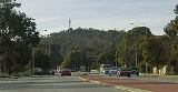
, on the edge of the Darling Scarp
Darling Scarp
The Darling Scarp, also referred to as the Darling Range or Darling Ranges, is a low escarpment running north-south to the east of the Swan Coastal Plain and Perth, Western Australia...
. It is a vital point in the transport routes from the Swan Coastal Plain
Swan Coastal Plain
The Swan Coastal Plain in Western Australia is the geographic feature which contains the Swan River as it travels west to the Indian Ocean. The coastal plain continues well beyond the boundaries of the Swan River and its tributaries, as a geological and biological zone, one of Western Australia's...
into the hinterland of Western Australia
Western Australia
Western Australia is a state of Australia, occupying the entire western third of the Australian continent. It is bounded by the Indian Ocean to the north and west, the Great Australian Bight and Indian Ocean to the south, the Northern Territory to the north-east and South Australia to the south-east...
.
Early Colonial History
Ensign Robert DaleRobert Dale
Lieutenant Robert Dale was the first European explorer to cross the Darling Range in Western Australia.Robert Dale was born in England in October 1812...
reached the summit on the 18th October 1829. John Septimus Roe
John Septimus Roe
John Septimus Roe was the first Surveyor-General of Western Australia. He was a renowned explorer, and a Member of Western Australia's Legislative and Executive Councils for nearly 40 years.-Early life:...
communicated with Dale over the York Road he had used the name Green Mount.
In the era of the Swan River Colony
Swan River Colony
The Swan River Colony was a British settlement established in 1829 on the Swan River, in Western Australia. The name was a pars pro toto for Western Australia. In 1832, the colony was officially renamed Western Australia, when the colony's founding Lieutenant-Governor, Captain James Stirling,...
the name 'Greenmount' was used for two points on the Darling Scarp. In the 1840s the York Road
York Road
-Australia:* York Road, Western Australia, an early name for portions of the Great Eastern Highway-Europe:* York Way, Islington, London, formerly named York Road * York Road, Lambeth, London-North America:United States...
was known as York Greenmount, and the road further north along the Scarp was known as Toodyay Greenmount. It is possible that these two locations might have had slightly different coloured foliage compared to the grey blue green colour of the Scarp.
During the convict era, in 1854 Edward Du Cane was the supervisor of the building of a convict depot on the slopes of the hill. In 1870s a government bluestone quarry was developed on the western slope of the hill.
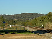
Railway
On its western slopes and southern slopes the original Eastern Railway route travelled. On its western slopes and just to the north the later National Park deviation ran. The current railway route still passes within a few kilometres to the west and north of the hill. Greenmount was a railway stopping place until 1954 when the Mundaring Loop was closed for passenger traffic, however trains continued to work on the line to the Mountain Quarry in Boya until 1962.Quarries
On its western slope and near its southern slope it has three unused quarries - Greenmount Quarry, Mountain Quarry, and Hudman Road Quarry. The Greenmount Quarry was known as the 'Blue Stone Quarry' in the 1870s, and was later associated in the late nineteenth century with the brother of John Forrest - Alexander ForrestAlexander Forrest
Alexander Forrest CMG, was an explorer and surveyor of Western Australia, as well as a politician.-Early life:Forrest was born at Picton, near Bunbury in Western Australia, the son of William and Margaret Forrest...
. Mountain Quarry was a working quarry from the 1920s until the early 1960s. It is now a dedicated abseiling location, and is often designated as 'Boya Quarry'. For more details about Hudman Road quarry to the south see the article on Boya
Boya, Western Australia
Boya is a locality on the Darling Scarp, in the Shire of Mundaring, Western Australia. On the south side of Greenmount Hill, and just west of Darlington....
.
Due to its visibility and lack of development on the hill, it has remained 'green' since its naming in the 1820s. It has attracted the interest of some artists and photographers. The only spoiling is the front part of the hill [locally known as 'Sugarloaf'], which was a pasture for over 60 years, and has a 'green' that is not the endemic green of the jarrah forest that once covered the hill. Also dissection by a Western Power line across the hill which corresponds with the old border of the Greenmount National Park has created an eyesore line, as well as a serious point of erosion.
It has also been the site of aircraft warning lights
Aircraft warning lights
Aircraft warning lights are high-intensity lighting devices that are attached to tall structures and are used as collision avoidance measures. Such devices make structures more visible to passing aircraft and are usually used at night, although they may be used during the day as well...
since removed, and currently has a police communication tower on the western edge. It also has a Mobile Telephone tower with Optus and Telstra Equipment near Padbury Road. Road access through the Greenmount National Park
Greenmount National Park
Greenmount National Park is a national park in the locality of Greenmount Western Australia , 22 km east of Perth.It is one of the smaller National Parks along the Darling Scarp and is a component of the Darling Range National Park....
has been closed due to vandalism, except where permission and keys have been obtained from the Department of Environment and Conservation regional office in Mundaring
Mundaring, Western Australia
Mundaring is a suburb located 34 km east of Perth on the Great Eastern Highway. The suburb is located within the Shire of Mundaring.The Aboriginal name of the area 'Mindah-lung', said to mean 'a high place on a high place', was anglicised to become 'Mundaring'.The Mundaring area is also considered...
.
The Greenmount locality is dissected by the Great Eastern Highway
Great Eastern Highway
The Great Eastern Highway is a major road between the Western Australian cities of Perth and Kalgoorlie. It is a key route for vehicles accessing the eastern wheatbelt and the eastern goldfields...
and other important roads.
Mundaring Municipal Inventory
The Shire of Mundaring Municipal Inventory has Greenmount Hill - as a landmark - with high aesthetic, social, historic and scientific significance.External links
- Greenmount on Geoscience AustraliaGeoscience AustraliaGeoscience Australia is an agency of the Australian federal government. It carries out geoscientific research.On a user pays basis it produces geospatial products such as topographic maps and satellite imagery.-History:...