
Great Appalachian Storm of November 1950
Encyclopedia
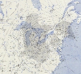
The Great Appalachian Storm of November 1950 was a large extratropical cyclone
which moved through the Eastern United States
, causing significant winds, heavy rains east of the Appalachians
, and blizzard
conditions along the western slopes of the mountain chain. Power was out to more than 1,000,000 customers during this event. In all, the storm impacted 22 states, killing 353, and creating US$66.7 million in damage (1950 dollars). At the time, U.S. insurance
companies paid more money out to their policy holders for damage resulting from this cyclone than for any other previous storm or hurricane.
conditions, the cold phase of ENSO
, which favors a storm track from the Ohio
and Tennessee Valley
s into the Appalachians. The cyclone
initially formed in southeast North Carolina
near a cold front on the morning of November 24 as the main cyclone over the Great Lakes
weakened. Rapid development ensued as the surface center began to migrate back into a closed 500 hPa (14.75 inHg)-level (around 6,000 m/20,000 ft above sea level) cyclone, and the cyclone bombed while moving north through Washington D.C. the next morning. The former occluded front to its northwest became a warm front which moved back to the west around the strengthening, and now dominant, southern low pressure center. By the evening of November 25, the cyclone retrograded, or moved northwestward, into Ohio
due to a blocking ridge up across eastern Canada. It was at this time that the pressure gradient was its most intense across southern New England
and eastern New York. The cyclone moved west over Lake Erie
to the north of the upper cyclone before looping over Ohio as the low-level and mid-level cyclone centers coupled. Significant convection within its comma head led to the development of a warm seclusion, or a pocket of low level warm air, near its center which aided in further development due to the increased lapse rate
s a warmer low level environment affords under a cold low. After the system became stacked with height, the storm slowly spun down as it drifted north and northeast into eastern Canada over the succeeding few days.
rapidly deepened as it moved up the eastern side of the Appalachians during November 24 and November 25 and continued into November 27. Coastal flooding was seen along the U.S. coastline from New Jersey
northward.
(5˚F), Mobile
(22˚F), and Montgomery
(13˚F).
(24˚F), Pensacola
(22˚F), and Jacksonville
(23˚F).
(-3˚F), Columbus
(10˚F), Augusta
(11˚F), and Savannah
(15˚F).
(-1˚F).
recorded a wind gust of 110 miles per hour (177 km/h) during the height of the storm. Winds at Mount Washington
reached 160 miles per hour (257.5 km/h).
. A wind gust of 94 miles per hour (151.3 km/h) was recorded in New York City. Extensive damage was caused by the wind across New York, including massive tree fall and power outages. Coastal flooding breached dikes at LaGuardia Airport
, flooding the runways. Flooding extended to New York City's Office of Emergency Management on the Lower East Side
, in Manhattan
.
(-5˚F) and Wilmington
(16˚F).
, which combined with the wind and cold temperatures, became their worst blizzard on record. Nearly the entire state was blanketed with 10 inches (25.4 cm) of snow, with 20-30 inches (50–75 cm) being measured in eastern sections of Ohio. The highest report was 44 inches (111.8 cm) from Steubenville
. Snow drifts were up to 25 feet (7.6 m) deep. Winds exceeded 40 miles per hour (64.4 km/h) with gusts as high as 60 miles per hour (96.6 km/h). Bulldozers were used to clear roads. Despite the high winds and snow, the annual football
game between the University of Michigan
and Ohio State University
went on as scheduled in Columbus
and was nicknamed the Snow Bowl. When the snow melted during the first four days of December, river flooding occurred in Cincinnati
.
at Fairmont Dam reached its highest stage since 1902. In Pittsburgh
, 30.5 inches (77.5 cm) of snow accumulated from this cyclone. Tanks were used to clear the resultant snow. When a warm spell visited the region during the first four days of December, river flooding struck Pittsburgh.
(17˚F) and Greenville
(11˚F).
(4˚F), Knoxville
(5˚F), Memphis
(9˚F), and Nashville
(-1˚F).
recorded 34.4 inches (87.3 cm) of snowfall during the passage of this low, which exceeded its snowiest November on record by over 5 inches (12.7 cm). Pickens
reported the highest amount from anywhere within the cyclone, with 57 inches (144.8 cm) measured. November 1950 became West Virginia
's snowiest month on record. This remarkably heavy snow led to 160 deaths.
on November 24. This set a record for single-day snowfall in November.
.
, October 22–25, 1923, and November 19–22, 1952 were considered analogous to this cyclone. Despite their similarities, there are some differences. For example, the 1913 event was much more destructive to Great Lakes
shipping, while the 1950 storm caused greater snowfall amounts.
Extratropical cyclone
Extratropical cyclones, sometimes called mid-latitude cyclones or wave cyclones, are a group of cyclones defined as synoptic scale low pressure weather systems that occur in the middle latitudes of the Earth having neither tropical nor polar characteristics, and are connected with fronts and...
which moved through the Eastern United States
Eastern United States
The Eastern United States, the American East, or simply the East is traditionally defined as the states east of the Mississippi River. The first two tiers of states west of the Mississippi have traditionally been considered part of the West, but can be included in the East today; usually in...
, causing significant winds, heavy rains east of the Appalachians
Appalachian Mountains
The Appalachian Mountains #Whether the stressed vowel is or ,#Whether the "ch" is pronounced as a fricative or an affricate , and#Whether the final vowel is the monophthong or the diphthong .), often called the Appalachians, are a system of mountains in eastern North America. The Appalachians...
, and blizzard
Blizzard
A blizzard is a severe snowstorm characterized by strong winds. By definition, the difference between blizzard and a snowstorm is the strength of the wind. To be a blizzard, a snow storm must have winds in excess of with blowing or drifting snow which reduces visibility to 400 meters or ¼ mile or...
conditions along the western slopes of the mountain chain. Power was out to more than 1,000,000 customers during this event. In all, the storm impacted 22 states, killing 353, and creating US$66.7 million in damage (1950 dollars). At the time, U.S. insurance
Insurance
In law and economics, insurance is a form of risk management primarily used to hedge against the risk of a contingent, uncertain loss. Insurance is defined as the equitable transfer of the risk of a loss, from one entity to another, in exchange for payment. An insurer is a company selling the...
companies paid more money out to their policy holders for damage resulting from this cyclone than for any other previous storm or hurricane.
Synoptic history
The preceding atmospheric state was one of La NiñaLa Niña
La Niña is a coupled ocean-atmosphere phenomenon that is the counterpart of El Niño as part of the broader El Niño-Southern Oscillation climate pattern. During a period of La Niña, the sea surface temperature across the equatorial Eastern Central Pacific Ocean will be lower than normal by 3–5 °C...
conditions, the cold phase of ENSO
Enso
Ensō is a Japanese word meaning "circle" and a concept strongly associated with Zen. Ensō is one of the most common subjects of Japanese calligraphy even though it is a symbol and not a character. It symbolizes the Absolute enlightenment, strength, elegance, the Universe, and the void; it can...
, which favors a storm track from the Ohio
Ohio River
The Ohio River is the largest tributary, by volume, of the Mississippi River. At the confluence, the Ohio is even bigger than the Mississippi and, thus, is hydrologically the main stream of the whole river system, including the Allegheny River further upstream...
and Tennessee Valley
Tennessee Valley
The Tennessee Valley is the drainage basin of the Tennessee River and is largely within the U.S. state of Tennessee. It stretches from southwest Kentucky to northwest Georgia and from northeast Mississippi to the mountains of Virginia and North Carolina...
s into the Appalachians. The cyclone
Cyclone
In meteorology, a cyclone is an area of closed, circular fluid motion rotating in the same direction as the Earth. This is usually characterized by inward spiraling winds that rotate anticlockwise in the Northern Hemisphere and clockwise in the Southern Hemisphere of the Earth. Most large-scale...
initially formed in southeast North Carolina
North Carolina
North Carolina is a state located in the southeastern United States. The state borders South Carolina and Georgia to the south, Tennessee to the west and Virginia to the north. North Carolina contains 100 counties. Its capital is Raleigh, and its largest city is Charlotte...
near a cold front on the morning of November 24 as the main cyclone over the Great Lakes
Great Lakes
The Great Lakes are a collection of freshwater lakes located in northeastern North America, on the Canada – United States border. Consisting of Lakes Superior, Michigan, Huron, Erie, and Ontario, they form the largest group of freshwater lakes on Earth by total surface, coming in second by volume...
weakened. Rapid development ensued as the surface center began to migrate back into a closed 500 hPa (14.75 inHg)-level (around 6,000 m/20,000 ft above sea level) cyclone, and the cyclone bombed while moving north through Washington D.C. the next morning. The former occluded front to its northwest became a warm front which moved back to the west around the strengthening, and now dominant, southern low pressure center. By the evening of November 25, the cyclone retrograded, or moved northwestward, into Ohio
Ohio
Ohio is a Midwestern state in the United States. The 34th largest state by area in the U.S.,it is the 7th‑most populous with over 11.5 million residents, containing several major American cities and seven metropolitan areas with populations of 500,000 or more.The state's capital is Columbus...
due to a blocking ridge up across eastern Canada. It was at this time that the pressure gradient was its most intense across southern New England
New England
New England is a region in the northeastern corner of the United States consisting of the six states of Maine, New Hampshire, Vermont, Massachusetts, Rhode Island, and Connecticut...
and eastern New York. The cyclone moved west over Lake Erie
Lake Erie
Lake Erie is the fourth largest lake of the five Great Lakes in North America, and the tenth largest globally. It is the southernmost, shallowest, and smallest by volume of the Great Lakes and therefore also has the shortest average water residence time. It is bounded on the north by the...
to the north of the upper cyclone before looping over Ohio as the low-level and mid-level cyclone centers coupled. Significant convection within its comma head led to the development of a warm seclusion, or a pocket of low level warm air, near its center which aided in further development due to the increased lapse rate
Lapse rate
The lapse rate is defined as the rate of decrease with height for an atmospheric variable. The variable involved is temperature unless specified otherwise. The terminology arises from the word lapse in the sense of a decrease or decline; thus, the lapse rate is the rate of decrease with height and...
s a warmer low level environment affords under a cold low. After the system became stacked with height, the storm slowly spun down as it drifted north and northeast into eastern Canada over the succeeding few days.
United States effects
This extratropical cycloneExtratropical cyclone
Extratropical cyclones, sometimes called mid-latitude cyclones or wave cyclones, are a group of cyclones defined as synoptic scale low pressure weather systems that occur in the middle latitudes of the Earth having neither tropical nor polar characteristics, and are connected with fronts and...
rapidly deepened as it moved up the eastern side of the Appalachians during November 24 and November 25 and continued into November 27. Coastal flooding was seen along the U.S. coastline from New Jersey
New Jersey
New Jersey is a state in the Northeastern and Middle Atlantic regions of the United States. , its population was 8,791,894. It is bordered on the north and east by the state of New York, on the southeast and south by the Atlantic Ocean, on the west by Pennsylvania and on the southwest by Delaware...
northward.
Alabama
All-time record lows for November were set at BirminghamBirmingham, Alabama
Birmingham is the largest city in Alabama. The city is the county seat of Jefferson County. According to the 2010 United States Census, Birmingham had a population of 212,237. The Birmingham-Hoover Metropolitan Area, in estimate by the U.S...
(5˚F), Mobile
Mobile, Alabama
Mobile is the third most populous city in the Southern US state of Alabama and is the county seat of Mobile County. It is located on the Mobile River and the central Gulf Coast of the United States. The population within the city limits was 195,111 during the 2010 census. It is the largest...
(22˚F), and Montgomery
Montgomery, Alabama
Montgomery is the capital of the U.S. state of Alabama, and is the county seat of Montgomery County. It is located on the Alabama River southeast of the center of the state, in the Gulf Coastal Plain. As of the 2010 census, Montgomery had a population of 205,764 making it the second-largest city...
(13˚F).
Florida
All-time record lows for November were set at ApalachicolaApalachicola, Florida
Apalachicola is a city in Franklin County, Florida, on US 98 about southwest of Tallahassee. The population was 2,334 at the 2000 census. The 2005 census estimated the city's population at 2,340...
(24˚F), Pensacola
Pensacola, Florida
Pensacola is the westernmost city in the Florida Panhandle and the county seat of Escambia County, Florida, United States of America. As of the 2000 census, the city had a total population of 56,255 and as of 2009, the estimated population was 53,752...
(22˚F), and Jacksonville
Jacksonville, Florida
Jacksonville is the largest city in the U.S. state of Florida in terms of both population and land area, and the largest city by area in the contiguous United States. It is the county seat of Duval County, with which the city government consolidated in 1968...
(23˚F).
Georgia
All-time record lows for November were set at AtlantaAtlanta, Georgia
Atlanta is the capital and most populous city in the U.S. state of Georgia. According to the 2010 census, Atlanta's population is 420,003. Atlanta is the cultural and economic center of the Atlanta metropolitan area, which is home to 5,268,860 people and is the ninth largest metropolitan area in...
(-3˚F), Columbus
Columbus, Georgia
Columbus is a city in and the county seat of Muscogee County, Georgia, United States, with which it is consolidated. As of the 2010 census, the city had a population of 189,885. It is the principal city of the Columbus, Georgia metropolitan area, which, in 2009, had an estimated population of 292,795...
(10˚F), Augusta
Augusta, Georgia
Augusta is a consolidated city in the U.S. state of Georgia, located along the Savannah River. As of the 2010 census, the Augusta–Richmond County population was 195,844 not counting the unconsolidated cities of Hephzibah and Blythe.Augusta is the principal city of the Augusta-Richmond County...
(11˚F), and Savannah
Savannah, Georgia
Savannah is the largest city and the county seat of Chatham County, in the U.S. state of Georgia. Established in 1733, the city of Savannah was the colonial capital of the Province of Georgia and later the first state capital of Georgia. Today Savannah is an industrial center and an important...
(15˚F).
Kentucky
An all-time record low for November was set at LouisvilleLouisville, Kentucky
Louisville is the largest city in the U.S. state of Kentucky, and the county seat of Jefferson County. Since 2003, the city's borders have been coterminous with those of the county because of a city-county merger. The city's population at the 2010 census was 741,096...
(-1˚F).
New Hampshire
ConcordConcord, New Hampshire
The city of Concord is the capital of the state of New Hampshire in the United States. It is also the county seat of Merrimack County. As of the 2010 census, its population was 42,695....
recorded a wind gust of 110 miles per hour (177 km/h) during the height of the storm. Winds at Mount Washington
Mount Washington (New Hampshire)
Mount Washington is the highest peak in the Northeastern United States at , famous for dangerously erratic weather. For 76 years, a weather observatory on the summit held the record for the highest wind gust directly measured at the Earth's surface, , on the afternoon of April 12, 1934...
reached 160 miles per hour (257.5 km/h).
New York
Sustained winds of 50-60 mph (80–100 km/h) with gusts to 83 miles per hour (133.6 km/h) were recorded at Albany, New YorkAlbany, New York
Albany is the capital city of the U.S. state of New York, the seat of Albany County, and the central city of New York's Capital District. Roughly north of New York City, Albany sits on the west bank of the Hudson River, about south of its confluence with the Mohawk River...
. A wind gust of 94 miles per hour (151.3 km/h) was recorded in New York City. Extensive damage was caused by the wind across New York, including massive tree fall and power outages. Coastal flooding breached dikes at LaGuardia Airport
LaGuardia Airport
LaGuardia Airport is an airport located in the northern part of Queens County on Long Island in the City of New York. The airport is located on the waterfront of Flushing Bay and Bowery Bay, and borders the neighborhoods of Astoria, Jackson Heights and East Elmhurst. The airport was originally...
, flooding the runways. Flooding extended to New York City's Office of Emergency Management on the Lower East Side
Lower East Side
The Lower East Side, LES, is a neighborhood in the southeastern part of the New York City borough of Manhattan. It is roughly bounded by Allen Street, East Houston Street, Essex Street, Canal Street, Eldridge Street, East Broadway, and Grand Street....
, in Manhattan
Manhattan
Manhattan is the oldest and the most densely populated of the five boroughs of New York City. Located primarily on the island of Manhattan at the mouth of the Hudson River, the boundaries of the borough are identical to those of New York County, an original county of the state of New York...
.
North Carolina
All-time record lows for November were set at AshevilleAsheville, North Carolina
Asheville is a city in and the county seat of Buncombe County, North Carolina, United States. It is the largest city in Western North Carolina, and the 11th largest city in North Carolina. The City is home to the United States National Climatic Data Center , which is the world's largest active...
(-5˚F) and Wilmington
Wilmington, North Carolina
Wilmington is a port city in and is the county seat of New Hanover County, North Carolina, United States. The population is 106,476 according to the 2010 Census, making it the eighth most populous city in the state of North Carolina...
(16˚F).
Ohio
On the storm's west side, nearly a foot of snow fell on Dayton, OhioDayton, Ohio
Dayton is the 6th largest city in the U.S. state of Ohio and the county seat of Montgomery County, the fifth most populous county in the state. The population was 141,527 at the 2010 census. The Dayton Metropolitan Statistical Area had a population of 841,502 in the 2010 census...
, which combined with the wind and cold temperatures, became their worst blizzard on record. Nearly the entire state was blanketed with 10 inches (25.4 cm) of snow, with 20-30 inches (50–75 cm) being measured in eastern sections of Ohio. The highest report was 44 inches (111.8 cm) from Steubenville
Steubenville, Ohio
Steubenville is a city located along the Ohio River in Jefferson County, Ohio on the Ohio-West Virginia border in the United States. It is the political county seat of Jefferson County. It is also a principal city of the Weirton–Steubenville, WV-OH Metropolitan Statistical Area...
. Snow drifts were up to 25 feet (7.6 m) deep. Winds exceeded 40 miles per hour (64.4 km/h) with gusts as high as 60 miles per hour (96.6 km/h). Bulldozers were used to clear roads. Despite the high winds and snow, the annual football
College football
College football refers to American football played by teams of student athletes fielded by American universities, colleges, and military academies, or Canadian football played by teams of student athletes fielded by Canadian universities...
game between the University of Michigan
Michigan Wolverines football
The Michigan Wolverines football program represents the University of Michigan in college football at the NCAA Division I Football Bowl Subdivision level. Michigan has the most all-time wins and the highest winning percentage in college football history...
and Ohio State University
Ohio State Buckeyes football
The Ohio State Buckeyes football team is an intercollegiate varsity sports team of The Ohio State University. The team is a member of the Big Ten Conference of the NCAA, playing at the Division I Football Bowl Subdivision, formerly Division I-A, level. The team nickname is derived from the state...
went on as scheduled in Columbus
Columbus, Ohio
Columbus is the capital of and the largest city in the U.S. state of Ohio. The broader metropolitan area encompasses several counties and is the third largest in Ohio behind those of Cleveland and Cincinnati. Columbus is the third largest city in the American Midwest, and the fifteenth largest city...
and was nicknamed the Snow Bowl. When the snow melted during the first four days of December, river flooding occurred in Cincinnati
Cincinnati, Ohio
Cincinnati is a city in the U.S. state of Ohio. Cincinnati is the county seat of Hamilton County. Settled in 1788, the city is located to north of the Ohio River at the Ohio-Kentucky border, near Indiana. The population within city limits is 296,943 according to the 2010 census, making it Ohio's...
.
Pennsylvania
During the reign of the storm, record to near-record flooding occurred along the eastern side of the Appalachians across eastern and central sections of the state. The SchuylkillSchuylkill River
The Schuylkill River is a river in Pennsylvania. It is a designated Pennsylvania Scenic River.The river is about long. Its watershed of about lies entirely within the state of Pennsylvania. The source of its eastern branch is in the Appalachian Mountains at Tuscarora Springs, near Tamaqua in...
at Fairmont Dam reached its highest stage since 1902. In Pittsburgh
Pittsburgh, Pennsylvania
Pittsburgh is the second-largest city in the US Commonwealth of Pennsylvania and the county seat of Allegheny County. Regionally, it anchors the largest urban area of Appalachia and the Ohio River Valley, and nationally, it is the 22nd-largest urban area in the United States...
, 30.5 inches (77.5 cm) of snow accumulated from this cyclone. Tanks were used to clear the resultant snow. When a warm spell visited the region during the first four days of December, river flooding struck Pittsburgh.
South Carolina
All-time record lows for November were set at CharlestonCharleston, South Carolina
Charleston is the second largest city in the U.S. state of South Carolina. It was made the county seat of Charleston County in 1901 when Charleston County was founded. The city's original name was Charles Towne in 1670, and it moved to its present location from a location on the west bank of the...
(17˚F) and Greenville
Greenville, South Carolina
-Law and government:The city of Greenville adopted the Council-Manager form of municipal government in 1976.-History:The area was part of the Cherokee Nation's protected grounds after the Treaty of 1763, which ended the French and Indian War. No White man was allowed to enter, though some families...
(11˚F).
Tennessee
All-time record lows for November were set at ChattanoogaChattanooga, Tennessee
Chattanooga is the fourth-largest city in the US state of Tennessee , with a population of 169,887. It is the seat of Hamilton County...
(4˚F), Knoxville
Knoxville, Tennessee
Founded in 1786, Knoxville is the third-largest city in the U.S. state of Tennessee, U.S.A., behind Memphis and Nashville, and is the county seat of Knox County. It is the largest city in East Tennessee, and the second-largest city in the Appalachia region...
(5˚F), Memphis
Memphis, Tennessee
Memphis is a city in the southwestern corner of the U.S. state of Tennessee, and the county seat of Shelby County. The city is located on the 4th Chickasaw Bluff, south of the confluence of the Wolf and Mississippi rivers....
(9˚F), and Nashville
Nashville, Tennessee
Nashville is the capital of the U.S. state of Tennessee and the county seat of Davidson County. It is located on the Cumberland River in Davidson County, in the north-central part of the state. The city is a center for the health care, publishing, banking and transportation industries, and is home...
(-1˚F).
West Virginia
ParkersburgParkersburg, West Virginia
As of the census of 2000, there were 33,099 people, 14,467 households, and 8,767 families residing in the city. In 2006 the U.S. Census Bureau estimated that Parkersburg's population had decreased 4.4% to 31,755. The population density was 2,800.5 people per square mile . There were 16,100 housing...
recorded 34.4 inches (87.3 cm) of snowfall during the passage of this low, which exceeded its snowiest November on record by over 5 inches (12.7 cm). Pickens
Pickens, West Virginia
Pickens is an unincorporated census-designated place in Randolph County, West Virginia, United States. Pickens is west-southwest of Huttonsville. It is the home of the Cunningham-Roberts Museum. Pickens has a post office with ZIP code 26230. As of the 2010 census, its population was 66....
reported the highest amount from anywhere within the cyclone, with 57 inches (144.8 cm) measured. November 1950 became West Virginia
West Virginia
West Virginia is a state in the Appalachian and Southeastern regions of the United States, bordered by Virginia to the southeast, Kentucky to the southwest, Ohio to the northwest, Pennsylvania to the northeast and Maryland to the east...
's snowiest month on record. This remarkably heavy snow led to 160 deaths.
Ontario
This system was a major snowstorm for the area, with 12 inches (30.5 cm) in TorontoToronto
Toronto is the provincial capital of Ontario and the largest city in Canada. It is located in Southern Ontario on the northwestern shore of Lake Ontario. A relatively modern city, Toronto's history dates back to the late-18th century, when its land was first purchased by the British monarchy from...
on November 24. This set a record for single-day snowfall in November.
Lasting impact
This cyclone was used as a test case for some of the first attempts at numerical modeling of the atmosphere, and is still used as a case study to run recent versions of forecast models. These studies helped create what is now known as the National Centers for Environmental PredictionNational Centers for Environmental Prediction
The United States National Centers for Environmental Prediction delivers national and global weather, water, climate and space weather guidance, forecasts, warnings and analyses to its Partners and External User Communities...
.
Other similar storms
Storms during the time frames November 8–10, 1913Great Lakes Storm of 1913
The Great Lakes Storm of 1913, historically referred to as the "Big Blow", "Jeff Kinsland's Wash," the "Freshwater Fury" or the "White Hurricane", was a blizzard with hurricane-force winds that devastated the Great Lakes Basin in the Midwestern United States and the Canadian province of Ontario...
, October 22–25, 1923, and November 19–22, 1952 were considered analogous to this cyclone. Despite their similarities, there are some differences. For example, the 1913 event was much more destructive to Great Lakes
Great Lakes
The Great Lakes are a collection of freshwater lakes located in northeastern North America, on the Canada – United States border. Consisting of Lakes Superior, Michigan, Huron, Erie, and Ontario, they form the largest group of freshwater lakes on Earth by total surface, coming in second by volume...
shipping, while the 1950 storm caused greater snowfall amounts.