

Cowie Water
Encyclopedia
River
A river is a natural watercourse, usually freshwater, flowing towards an ocean, a lake, a sea, or another river. In a few cases, a river simply flows into the ground or dries up completely before reaching another body of water. Small rivers may also be called by several other names, including...
rising in the Grampian Mountains
Grampian Mountains (Scotland)
The Grampian Mountains or Grampians are one of the three major mountain ranges in Scotland, occupying a considerable portion of the Scottish Highlands in northeast Scotland.-Extent:...
in Aberdeenshire
Aberdeenshire
Aberdeenshire is one of the 32 unitary council areas in Scotland and a lieutenancy area.The present day Aberdeenshire council area does not include the City of Aberdeen, now a separate council area, from which its name derives. Together, the modern council area and the city formed historic...
, Scotland
Scotland
Scotland is a country that is part of the United Kingdom. Occupying the northern third of the island of Great Britain, it shares a border with England to the south and is bounded by the North Sea to the east, the Atlantic Ocean to the north and west, and the North Channel and Irish Sea to the...
that discharges to the North Sea
North Sea
In the southwest, beyond the Straits of Dover, the North Sea becomes the English Channel connecting to the Atlantic Ocean. In the east, it connects to the Baltic Sea via the Skagerrak and Kattegat, narrow straits that separate Denmark from Norway and Sweden respectively...
in the northern part of Stonehaven
Stonehaven
Stonehaven is a town in Aberdeenshire, Scotland. It lies on Scotland's northeast coast and had a population of 9,577 in 2001 census.Stonehaven, county town of Kincardineshire, grew around an Iron Age fishing village, now the "Auld Toon" , and expanded inland from the seaside...
. south of the ruined Cowie Castle
Cowie Castle
Cowie Castle is a ruined fortress in Aberdeenshire, Scotland. The site lies at the northern end of Stonehaven near the North Sea coast. To the immediate south is the Cowie Bridge crossing of the Cowie Water. Evidence of prehistoric man exists in the vicinity dating to the Iron Age in the form of...
. Tributaries of the Cowie Water include the Burn of Monboys
Burn of Monboys
Burn of Monboys is a stream that rises in the Mounth, or eastern range of the Grampian Mountains, northwest of Stonehaven and south of Netherley, Aberdeenshire, Scotland...
, which drains the area to the north, in which the archaeological site Raedykes
Raedykes
Raedykes is the site of a Roman marching camp located just over 3 miles NW of Stonehaven, Aberdeenshire, Scotland. National Grid Reference NO 842902...
Roman Camp is situated; and Cowton Burn
Cowton Burn
Cowton Burn is a stream that rises in the Mounth, or eastern range of the Grampian Mountains, on some of the northwest slopes of the Durris Forest west of Netherley, Aberdeenshire, Scotland. The Grid Reference for the headwaters is NO 925 823); Cowton Burn is a tributary to the Cowie Water...
.
Notable features in this vicinity include Dunnottar Castle
Dunnottar Castle
Dunnottar Castle is a ruined medieval fortress located upon a rocky headland on the north-east coast of Scotland, about two miles south of Stonehaven. The surviving buildings are largely of the 15th–16th centuries, but the site is believed to have been an early fortress of the Dark Ages...
, Fetteresso Castle
Fetteresso Castle
Fetteresso Castle is a 14th century towerhouse, rebuilt in 1761 as a Scottish gothic style Palladian manor, with clear evidence of prehistoric use of the site. It is situated immediately west of the town of Stonehaven in Kincardineshire slightly to the west of the A90 dual carriageway...
and Muchalls Castle
Muchalls Castle
Muchalls Castle stands overlooking the North Sea in the countryside of Kincardine and Mearns, Aberdeenshire, Scotland. The lower course is a well preserved double groined 13th century towerhouse structure, built by the Frasers of Muchalls. Upon this structure, the 17th century castle was begun by...
. Other nearby coast
Coast
A coastline or seashore is the area where land meets the sea or ocean. A precise line that can be called a coastline cannot be determined due to the dynamic nature of tides. The term "coastal zone" can be used instead, which is a spatial zone where interaction of the sea and land processes occurs...
al waterways discharging to the North Sea include Burn of Muchalls
Burn of Muchalls
The Burn of Muchalls is an easterly flowing stream in Aberdeenshire, Scotland that discharges to the North Sea. Its point of discharge is on a rocky beach set with scenic sea stacks...
to the north and Carron Water
Carron Water, Aberdeenshire
Carron Water is a river in Aberdeenshire, Scotland.Carron Water rises in Fetteresso Forest on the eastern edge of the Grampians. It flows past Fetteresso Castle and discharges into the North Sea at Stonehaven Bay. Carron Water separates the Old Town from Stonehaven's new town , laid out in...
to the south.
Hydrology and water quality
Summer flow rates are typically in the range of 200 cuft/s at the river's mouth. July values for pHPH
In chemistry, pH is a measure of the acidity or basicity of an aqueous solution. Pure water is said to be neutral, with a pH close to 7.0 at . Solutions with a pH less than 7 are said to be acidic and solutions with a pH greater than 7 are basic or alkaline...
have been measured at 8.2 or slightly alkaline July water temperatures are about 11.9 degrees Celsius and electrical conductivity at Cowie Bridge
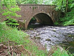
Cowie Bridge
Cowie Bridge is a roadway bridge across the Cowie Water in Stonehaven, Scotland near the river's mouth at the North Sea. This construction is a listed historical structure in Aberdeenshire. Historically the area in the vicinity of the Cowie Bridge site has been an old fishing village known as...
near the mouth has been measured at a relatively low value of .07 micro-Siemens per meter. Turbidity
Turbidity
Turbidity is the cloudiness or haziness of a fluid caused by individual particles that are generally invisible to the naked eye, similar to smoke in air. The measurement of turbidity is a key test of water quality....
measured exactly 24 hours after a moderate rainfall of one centimeter was 14 JTU in a July circumstance.