
Glarus thrust
Encyclopedia
The Glarus thrust is a major thrust fault
in the Alps
of eastern Switzerland
. Along the thrust the Helvetic nappes
were thrusted more than 100 km to the north over the external Aarmassif
and Infrahelvetic complex
. The thrust forms the contact between older (Helvetic) Permo
-Triassic
rock layers of the Verrucano group and younger (external) Jurassic
and Cretaceous
limestone
s and Paleogene
flysch
and molasse
.
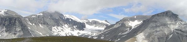
The Glarus thrust crops out
over a relatively large area in the cantons
Glarus, St. Gallen
and Graubünden
, due to its horizontal orientation and the high local relief
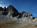
. Famous outcrops include those at Lochsite near Glarus
(the town) and in a mountain cliff called Tschingelhörner
between Elm
and Flims
(in the same cliff is a natural hole called the Martinsloch).
knowledge on mountain building. For this reason the area in which the thrust is found was declared a geotope
, a geologic UNESCO
world heritage site
, under the name "Swiss Tectonic Arena Sardona." The area of this "tectonic arena" encompasses 32,850 hectare
s of mainly mountainous landscape in 19 communities between the Surselva, Linth
tal and Walensee. In the arena are a number of peaks higher than 3000 meters, such as Surenstock (its Romansh name is Piz Sardona, from which the name comes), Ringelspitz
and Pizol
.
In 2006 the Swiss government made a first proposal to declare the region world heritage to the International Union for Conservation of Nature (IUCN). The IUCN then did not find the area to have an extraordinary or universal value and denied the proposal. The Swiss made a new, this time successful proposal in March 2008. The region was declared world heritage in July 2008, because "the area displays an exceptional example of mountain building through continental collision and features excellent geological sections through tectonic thrust."
The American Museum of Natural History
in New York
exposes a full-scale reconstruction of the Glarus thrust.
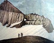

to examine the Glarus thrust was Hans Conrad Escher von der Linth
(1767–1823). Escher von der Linth discovered that, contradictory to Steno's law of superposition
, older rocks are on top of younger ones in certain outcrop
s in Glarus. His son Arnold Escher von der Linth
(1807–1872), the first professor in geology at the ETH at Zürich
, mapped the structure in more detail and concluded that it could be a huge thrust. At the time, most geologists believed in the theory of geosyncline
s, which states that mountains are formed by vertical movements within the Earth's crust
. Escher von der Linth had therefore difficulty with explaining the size of the thrust fault. In 1848 he invited the British geologist Roderick Murchison
, an international authority, to come and look at the structure. Murchison was familiar with larger thrust faults in Scotland and agreed with Eschers interpretation. However, Escher himself felt insecure about his idea and when he published his observations in 1866 he instead interpreted the Glarus thrust as two large overturned narrow anticline
s. This hypothesis was rather absurd, as he admitted himself in private.
Eschers successor as professor at Zürich, Albert Heim
(1849–1937), initially stuck to his predecessors interpretation of two anticlines. However, some geologists favoured the idea of a thrust. One of them was Marcel Alexandre Bertrand
(1847–1907), who interpreted the structure as a thrust in 1884, after reading Heims observations. Bertrand was familiar with the Faille du Midi, a large thrust fault in the Belgian
Ardennes
. Meanwhile, British geologists began to recognize the nature of thrust faults in the Scottish Highlands
. In 1883, Archibald Geikie
accepted that the Highlands are a thrust system. Swiss geologists Hans Schardt and Maurice Lugeon
then discovered in 1893 that in western Switzerland, Jurassic rock layers are on top of younger molasse too, and argued that the structure of the Alps is a large stack of nappe
s, large sheets of rock that had been thrusted on top of each other. At the turn of the century, Heim was also convinced of the new theory. He and other Swiss geologists now started mapping the nappes of Switzerland in more detail. From that moment on, geologists began recognizing large thrusts in many mountain chains around the world.
However, it was still not understood where the huge forces that moved the nappes came from. Only with the arrival of plate tectonic theory
in the 1950s an explanation was found. In plate tectonics, the horizontal movement of tectonic plates over the Earth's soft asthenosphere
causes horizontal forces within the crust. Presently, geologists believe most mountain chains are formed by convergent movements between tectonic plates.
Thrust fault
A thrust fault is a type of fault, or break in the Earth's crust across which there has been relative movement, in which rocks of lower stratigraphic position are pushed up and over higher strata. They are often recognized because they place older rocks above younger...
in the Alps
Alps
The Alps is one of the great mountain range systems of Europe, stretching from Austria and Slovenia in the east through Italy, Switzerland, Liechtenstein and Germany to France in the west....
of eastern Switzerland
Switzerland
Switzerland name of one of the Swiss cantons. ; ; ; or ), in its full name the Swiss Confederation , is a federal republic consisting of 26 cantons, with Bern as the seat of the federal authorities. The country is situated in Western Europe,Or Central Europe depending on the definition....
. Along the thrust the Helvetic nappes
Helvetic nappes
The Helvetic zone, Helvetic system or the Helveticum is a geologic subdivision of the Alps. The Helvetic zone crops out mainly in Switzerland, hence the name . Rocks in the Helvetic zone are sedimentary and were originally deposited at the southern margin of the European plate...
were thrusted more than 100 km to the north over the external Aarmassif
Aarmassif
The Aarmassif or Aaremassif is a geologic massif in the Swiss Alps. It contains a number of large mountain chains and parts of mountain chains.-Geography:...
and Infrahelvetic complex
Infrahelvetic complex
The Infrahelvetic complex is a tectonic unit in the Swiss Alps. It consists of autochthonous rocks of the former southern continental margin of the European Plate....
. The thrust forms the contact between older (Helvetic) Permo
Permian
The PermianThe term "Permian" was introduced into geology in 1841 by Sir Sir R. I. Murchison, president of the Geological Society of London, who identified typical strata in extensive Russian explorations undertaken with Edouard de Verneuil; Murchison asserted in 1841 that he named his "Permian...
-Triassic
Triassic
The Triassic is a geologic period and system that extends from about 250 to 200 Mya . As the first period of the Mesozoic Era, the Triassic follows the Permian and is followed by the Jurassic. Both the start and end of the Triassic are marked by major extinction events...
rock layers of the Verrucano group and younger (external) Jurassic
Jurassic
The Jurassic is a geologic period and system that extends from about Mya to Mya, that is, from the end of the Triassic to the beginning of the Cretaceous. The Jurassic constitutes the middle period of the Mesozoic era, also known as the age of reptiles. The start of the period is marked by...
and Cretaceous
Cretaceous
The Cretaceous , derived from the Latin "creta" , usually abbreviated K for its German translation Kreide , is a geologic period and system from circa to million years ago. In the geologic timescale, the Cretaceous follows the Jurassic period and is followed by the Paleogene period of the...
limestone
Limestone
Limestone is a sedimentary rock composed largely of the minerals calcite and aragonite, which are different crystal forms of calcium carbonate . Many limestones are composed from skeletal fragments of marine organisms such as coral or foraminifera....
s and Paleogene
Paleogene
The Paleogene is a geologic period and system that began 65.5 ± 0.3 and ended 23.03 ± 0.05 million years ago and comprises the first part of the Cenozoic Era...
flysch
Flysch
Flysch is a sequence of sedimentary rocks that is deposited in a deep marine facies in the foreland basin of a developing orogen. Flysch is typically deposited during an early stage of the orogenesis. When the orogen evolves the foreland basin becomes shallower and molasse is deposited on top of...
and molasse
Molasse
The term "molasse" refers to the sandstones, shales and conglomerates formed as terrestrial or shallow marine deposits in front of rising mountain chains. The molasse is deposited in a foreland basin, especially on top of flysch, for example that left from the rising Alps, or erosion in the Himalaya...
.
The Glarus thrust crops out
Outcrop
An outcrop is a visible exposure of bedrock or ancient superficial deposits on the surface of the Earth. -Features:Outcrops do not cover the majority of the Earth's land surface because in most places the bedrock or superficial deposits are covered by a mantle of soil and vegetation and cannot be...
over a relatively large area in the cantons
Cantons of Switzerland
The 26 cantons of Switzerland are the member states of the federal state of Switzerland. Each canton was a fully sovereign state with its own borders, army and currency from the Treaty of Westphalia until the establishment of the Swiss federal state in 1848...
Glarus, St. Gallen
Canton of St. Gallen
The Canton of St. Gallen is a canton of Switzerland. St. Gallen is located in the north east of Switzerland. It covers an area of 2,026 km², and has a population of . , the population included 97,461 foreigners, or about 20.9% of the total population. The capital is St. Gallen. Spelling...
and Graubünden
Graubünden
Graubünden or Grisons is the largest and easternmost canton of Switzerland. The canton shares borders with the cantons of Ticino, Uri, Glarus and St. Gallen and international borders with Italy, Austria and Liechtenstein...
, due to its horizontal orientation and the high local relief
Relief
Relief is a sculptural technique. The term relief is from the Latin verb levo, to raise. To create a sculpture in relief is thus to give the impression that the sculpted material has been raised above the background plane...
. Famous outcrops include those at Lochsite near Glarus
Glarus
Glarus is the capital of the Canton of Glarus in Switzerland. Glarus municipality since 1 January 2011 incorporates the former municipalities of Ennenda, Netstal and Riedern....
(the town) and in a mountain cliff called Tschingelhörner
Tschingelhörner
Tschingelhörner is a mountain in the Glarus Alps, located on the border between the cantons of Glarus and Graubünden in Switzerland. It is in fact composed of differents summits on a 1 km long ridge, situated south-west of Piz Segnas. The mountain is part of the Swiss Tectonic Arena Sardona...
between Elm
Elm, Switzerland
-Culture:In 1981, the Wakker Prize was awarded to Elm for the development and preservation of its architectural heritage....
and Flims
Flims
Flims is a municipality in the district of Imboden in the Swiss canton of Graubünden. The town of Flims is dominated by the Flimserstein which you can see from almost anywhere in the area....
(in the same cliff is a natural hole called the Martinsloch).
World heritage
Thrust faults of this kind are not uncommon in many mountain chains around the world, but the Glarus thrust is a well accessible example and has as such played an important role in the development of geologicalGeology
Geology is the science comprising the study of solid Earth, the rocks of which it is composed, and the processes by which it evolves. Geology gives insight into the history of the Earth, as it provides the primary evidence for plate tectonics, the evolutionary history of life, and past climates...
knowledge on mountain building. For this reason the area in which the thrust is found was declared a geotope
Geotope
Geotope is the geological component of the abiotic matrix present in an ecotope. Example geotopes might be: an exposed outcrop of rocks, an erratic boulder, a grotto or ravine, a cave, an old stone wall marking a property boundary, and so forth....
, a geologic UNESCO
UNESCO
The United Nations Educational, Scientific and Cultural Organization is a specialized agency of the United Nations...
world heritage site
World Heritage Site
A UNESCO World Heritage Site is a place that is listed by the UNESCO as of special cultural or physical significance...
, under the name "Swiss Tectonic Arena Sardona." The area of this "tectonic arena" encompasses 32,850 hectare
Hectare
The hectare is a metric unit of area defined as 10,000 square metres , and primarily used in the measurement of land. In 1795, when the metric system was introduced, the are was defined as being 100 square metres and the hectare was thus 100 ares or 1/100 km2...
s of mainly mountainous landscape in 19 communities between the Surselva, Linth
Linth
The Linth is a Swiss river starting above Linthal the mountains of Glarus near the Klausen Pass and flowing from there north through the Glarus valley passing Schwanden, where it is joined by its main tributary Sernft, Ennenda, the town of Glarus, Netstal, and Näfels, from where it is channeled to...
tal and Walensee. In the arena are a number of peaks higher than 3000 meters, such as Surenstock (its Romansh name is Piz Sardona, from which the name comes), Ringelspitz
Ringelspitz
The Ringelspitz, or Piz Barghis is a mountain in the Glarus Alps, located on the border between the cantons of St. Gallen and Graubünden. It is the highest summit of the canton of St...
and Pizol
Pizol
The Pizol is a mountain in the Glarus Alps, overlooking Bad Ragaz in the canton of St. Gallen. At 2,844 metres above sea level, it is the highest summit of the chain separating the valleys of the Seez and the Tamina and the highest mountain lying entirely within the canton of St...
.
In 2006 the Swiss government made a first proposal to declare the region world heritage to the International Union for Conservation of Nature (IUCN). The IUCN then did not find the area to have an extraordinary or universal value and denied the proposal. The Swiss made a new, this time successful proposal in March 2008. The region was declared world heritage in July 2008, because "the area displays an exceptional example of mountain building through continental collision and features excellent geological sections through tectonic thrust."
The American Museum of Natural History
American Museum of Natural History
The American Museum of Natural History , located on the Upper West Side of Manhattan in New York City, United States, is one of the largest and most celebrated museums in the world...
in New York
New York City
New York is the most populous city in the United States and the center of the New York Metropolitan Area, one of the most populous metropolitan areas in the world. New York exerts a significant impact upon global commerce, finance, media, art, fashion, research, technology, education, and...
exposes a full-scale reconstruction of the Glarus thrust.
History
The first naturalistNatural history
Natural history is the scientific research of plants or animals, leaning more towards observational rather than experimental methods of study, and encompasses more research published in magazines than in academic journals. Grouped among the natural sciences, natural history is the systematic study...
to examine the Glarus thrust was Hans Conrad Escher von der Linth
Hans Conrad Escher von der Linth
Hans Conrad Escher von der Linth was a Swiss scientist, artist, and politician. He headed the "Great Council of Switzerland" in 1798, a period of French occupation. He also published a survey of the Swiss Alps and is perhaps most significant for his work in the project to "tame" the Linth river...
(1767–1823). Escher von der Linth discovered that, contradictory to Steno's law of superposition
Law of superposition
The law of superposition is a key axiom based on observations of natural history that is a foundational principle of sedimentary stratigraphy and so of other geology dependent natural sciences:...
, older rocks are on top of younger ones in certain outcrop
Outcrop
An outcrop is a visible exposure of bedrock or ancient superficial deposits on the surface of the Earth. -Features:Outcrops do not cover the majority of the Earth's land surface because in most places the bedrock or superficial deposits are covered by a mantle of soil and vegetation and cannot be...
s in Glarus. His son Arnold Escher von der Linth
Arnold Escher von der Linth
Arnold Escher von der Linth was a Swiss geologist, the son of Hans Conrad Escher von der Linth ....
(1807–1872), the first professor in geology at the ETH at Zürich
ETH Zurich
The Swiss Federal Institute of Technology Zurich or ETH Zürich is an engineering, science, technology, mathematics and management university in the City of Zurich, Switzerland....
, mapped the structure in more detail and concluded that it could be a huge thrust. At the time, most geologists believed in the theory of geosyncline
Geosyncline
In geology, geosyncline is a term still occasionally used for a subsiding linear trough that was caused by the accumulation of sedimentary rock strata deposited in a basin and subsequently compressed, deformed, and uplifted into a mountain range, with attendant volcanism and plutonism...
s, which states that mountains are formed by vertical movements within the Earth's crust
Crust (geology)
In geology, the crust is the outermost solid shell of a rocky planet or natural satellite, which is chemically distinct from the underlying mantle...
. Escher von der Linth had therefore difficulty with explaining the size of the thrust fault. In 1848 he invited the British geologist Roderick Murchison
Roderick Murchison
Sir Roderick Impey Murchison, 1st Baronet KCB DCL FRS FRSE FLS PRGS PBA MRIA was a Scottish geologist who first described and investigated the Silurian system.-Early life and work:...
, an international authority, to come and look at the structure. Murchison was familiar with larger thrust faults in Scotland and agreed with Eschers interpretation. However, Escher himself felt insecure about his idea and when he published his observations in 1866 he instead interpreted the Glarus thrust as two large overturned narrow anticline
Anticline
In structural geology, an anticline is a fold that is convex up and has its oldest beds at its core. The term is not to be confused with antiform, which is a purely descriptive term for any fold that is convex up. Therefore if age relationships In structural geology, an anticline is a fold that is...
s. This hypothesis was rather absurd, as he admitted himself in private.
Eschers successor as professor at Zürich, Albert Heim
Albert Heim
Albert Heim was a Swiss geologist, noted for his three-volume Geologie der Schweiz.Born at Zürich, he was educated at Zürich and Berlin universities. Very early in life he became interested in the physical features of the Alps, and at the age of sixteen he made a model of the Tödi group...
(1849–1937), initially stuck to his predecessors interpretation of two anticlines. However, some geologists favoured the idea of a thrust. One of them was Marcel Alexandre Bertrand
Marcel Alexandre Bertrand
Marcel Alexandre Bertrand was a French geologist who was born in Paris. He was a student at the École Polytechnique, and beginning in 1869 he attended the Ecole des Mines de Paris. Beginning in 1877 he performed geological mapping studies of Provence, Jura Mountains and the Alps...
(1847–1907), who interpreted the structure as a thrust in 1884, after reading Heims observations. Bertrand was familiar with the Faille du Midi, a large thrust fault in the Belgian
Belgium
Belgium , officially the Kingdom of Belgium, is a federal state in Western Europe. It is a founding member of the European Union and hosts the EU's headquarters, and those of several other major international organisations such as NATO.Belgium is also a member of, or affiliated to, many...
Ardennes
Ardennes
The Ardennes is a region of extensive forests, rolling hills and ridges formed within the Givetian Ardennes mountain range, primarily in Belgium and Luxembourg, but stretching into France , and geologically into the Eifel...
. Meanwhile, British geologists began to recognize the nature of thrust faults in the Scottish Highlands
Scottish Highlands
The Highlands is an historic region of Scotland. The area is sometimes referred to as the "Scottish Highlands". It was culturally distinguishable from the Lowlands from the later Middle Ages into the modern period, when Lowland Scots replaced Scottish Gaelic throughout most of the Lowlands...
. In 1883, Archibald Geikie
Archibald Geikie
Sir Archibald Geikie, OM, KCB, PRS, FRSE , was a Scottish geologist and writer.-Early life:Geikie was born in Edinburgh in 1835, the eldest son of musician and music critic James Stuart Geikie...
accepted that the Highlands are a thrust system. Swiss geologists Hans Schardt and Maurice Lugeon
Maurice Lugeon
Maurice Lugeon was a Swiss geologist, and the pioneer of nappe tectonics. He was a pupil of Eugène Renevier. Named for Maurice Lugeon, the lugeon is a measure of transmissivity in rocks, determined by pressurized injection of water through a bore hole driven through the rock...
then discovered in 1893 that in western Switzerland, Jurassic rock layers are on top of younger molasse too, and argued that the structure of the Alps is a large stack of nappe
Nappe
In geology, a nappe is a large sheetlike body of rock that has been moved more than or 5 km from its original position. Nappes form during continental plate collisions, when folds are sheared so much that they fold back over on themselves and break apart. The resulting structure is a...
s, large sheets of rock that had been thrusted on top of each other. At the turn of the century, Heim was also convinced of the new theory. He and other Swiss geologists now started mapping the nappes of Switzerland in more detail. From that moment on, geologists began recognizing large thrusts in many mountain chains around the world.
However, it was still not understood where the huge forces that moved the nappes came from. Only with the arrival of plate tectonic theory
Plate tectonics
Plate tectonics is a scientific theory that describes the large scale motions of Earth's lithosphere...
in the 1950s an explanation was found. In plate tectonics, the horizontal movement of tectonic plates over the Earth's soft asthenosphere
Asthenosphere
The asthenosphere is the highly viscous, mechanically weak and ductilely-deforming region of the upper mantle of the Earth...
causes horizontal forces within the crust. Presently, geologists believe most mountain chains are formed by convergent movements between tectonic plates.