

Phoenix Islands
Encyclopedia
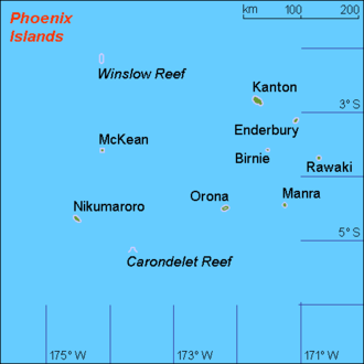
The Phoenix Islands are a group of eight atoll
s and two submerged coral
reefs, lying in the central Pacific Ocean
east of the Gilbert Islands
and west of the Line Islands
. They are a part of the Republic of Kiribati
. During the late 1930s they became the site of the last attempted colonial expansion of the British Empire
(the Phoenix Islands Settlement Scheme
). The islands and surrounding areas are home to some 120 species of coral and more than 500 species of fish
. On January 28, 2008, the government of Kiribati formally declared the entire Phoenix group and surrounding waters a protected area
, making its 410,500 square kilometres the world's largest marine protected area.
The group is uninhabited except for a few families on Kanton
. The United States
unincorporated territories of Baker Island
and Howland Island
are often considered northerly outliers of the group, in the geographical sense. Howland and Baker are statistically grouped with the United States Minor Outlying Islands
, however. The United States previously claimed all the Phoenix Islands under the Guano Islands Act
. The Treaty of Tarawa
released all American claims to Kiribati, excluding Baker and Howland.
At various times, the islands were considered part of the Gilbert group (once also known as "Kingsmill"). The name "Phoenix" for this group of islands seems to have been settled on in the 1840s, after an island of that name within the group. Phoenix Island was probably named after one of the many whaleships of that name plying these waters in the early 19th century.
. The chain comprises a portion of Kiribati
. The only island of any commercial or historical importance is Kanton (or Abariringa) Island. The other islands include Enderbury, Rawaki (formerly Phoenix), Manra (formerly Sydney), Birnie, McKean, Nikumaroro (formerly Gardner), and Orona (formerly Hull).
 Kanton
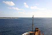
, or Abariringa Island, is the northernmost and sole (as of 2007) inhabited island in the Phoenix group. It is a narrow ribbon of land (9 km2 in area), enclosing a lagoon of approximately 40 km2. Kanton is mostly bare coral, covered with herbs, bunch grasses, low shrubs and a few trees. Its lagoon teems with 153 known species of marine life, including sharks, tuna, stingrays and eels. Land fauna includes at least 23 bird species, lizards, rats, hermit crabs and turtles.
Once an important trans-Pacific airport and refueling station, Kanton declined in importance with the introduction of long-range jet aircraft in the late 1950s, and was eventually abandoned after serving a brief stint as a U.S. missile-tracking station. Today, the island still exhibits the remains of the airline and military presence, with 41 persons (as of 2005) residing there, most living in abandoned structures from the U.S./UK occupation (1936–1976).
is a low, flat, small coral atoll lying 63 km (39 mi) ESE of Kanton. Its lagoon is rather tiny, comprising only a small percentage of the island's area. Herbs, bunchgrass, morning-glory vines and a few clumps of trees form the main vegetation on the island, while birds, rats and a species of beetle are the known fauna. Heavily mined for guano
in the late 19th century, Enderbury has seen little human impact following the evacuation of the last few colonists (four in number) in 1942, during World War II
.
is a small, flat coral island about 20 hectares in area, measuring 1.2 km (0.745647283979768 mi) long by 0.5 km (0.310686368324903 mi) wide. It contains a tiny lagoon, which has all but dried up. A nesting place for flocks of seabirds, Birnie is devoid of trees and is instead covered with low shrubs and grass. Unlike most of the other Phoenix Islands, Birnie does not appear to have been worked for guano or otherwise exploited by humans. It was declared a wildlife sanctuary in 1975.
is the northwesternmost island of the Phoenix group. Its area is 57 hectares, and devoid of fresh water or trees, though it does have a hypersaline lagoon in its center. Carpeted with low herbs and grasses, McKean provides a sanctuary for the world's largest nesting population of lesser frigatebird (Fregata ariel), with a population of up to 85,000 birds. Actively worked for guano in the mid-19th century, it was abandoned by 1870, and no further use has been made of it.
, estimated that two groups of people were present on Manra, one from Eastern Polynesia
, the other from Micronesia
. Wells and pits from these early inhabitants were also found.
Extensively worked for guano from 1884 by John T. Arundel
& Co, Manra was turned into a copra
plantation in the early 20th century. In 1938, Manra was selected as one of three atolls for use in the Phoenix Islands Settlement Scheme
, which represented the last expansion of the British Empire. Plagued by drought and the death of the project's organizer, together with the effects of World War II and the declining copra market, Manra was abandoned in 1963.
stands on the eastern tip of the island, together with ruins of shelters, graves and other platforms. Unlike Manra, Orona does not seem to have been worked for guano, but became a coconut plantation and a part of the British Phoenix Islands Settlement Scheme. Residents were evacuated in 1963, due to drought and the declining copra market.

, or Gardner Island, is approximately 6 km (4 mi) long by 2 km (1 mi) wide, enclosing a large central lagoon. Vegetation is profuse, including scrub forest, coconut palms and herbs. Large quantities of birds nest on the island, which was once the headquarters for the British colonial officer heading up the Phoenix Islands Settlement Scheme
, Gerald Gallagher
. Gallagher constructed a village on the western end of the atoll, with wide coral-paved streets, a parade ground, cooperative store, administrative center and residence, and radio shack.
Tragically, Gallagher died on Nikumaroro in 1941, and was buried on the island (where his empty grave monument can still be seen (though his remains were later moved to Tarawa). Like the other atolls in the settlement project, Nikumaroro was abandoned in 1963 due to the scarcity of fresh water, together with the declining market for copra produced on the island.
In recent years, Nikumaroro has become a news item due to a theory that Amelia Earhart
might have crash-landed her plane on the island during her fateful around-the-world attempt in 1937. The International Group for Historic Aircraft Recovery (TIGHAR) made several expeditions to Nikumaroro during the 1990s and first decade of the 21st century, finding possible evidence, but no conclusive proof, of this theory. Investigation and expeditions to the island continue.
and Pitcairn) were abandoned.
Such settlements probably began around 1000 BC, when eastern Melanesia
ns travelled north. Later settlement and contact by Polynesians is evident in archaeological digs revealing basalt artifacts originating in Samoa, the Marquesas, and the Cook Islands which were transported to the Phoenix and Line Islands during the 12th-14th centuries CE.
opened up in the early 19th century as whalers
from Europe and the Americas came in search of prey. The sudden influx of whaling vessels in the 1820s led to the discovery and initial charting of most of the Phoenix Islands between 1821-1825. This area was the last in the Pacific to be fully explored and charted, probably because the islands were predominantly small and isolated.
In 1568, when Spaniard Mendana
was commanded to explore the South Pacific, he sailed between the Line Islands
and the Phoenix Islands without sighting land, ultimately discovering "Isla de Jesus", probably amongst the Ellice group. While early 19th-century whalers were responsible for discovering most of Kiribati in the modern era, conflicting reports, inaccurate mapping and duplication of islands makes it almost impossible to confirm exactly who discovered each of the islands. Jeremiah N. Reynolds
's 1828 report to the American Navy recommended an exploring expedition to the Pacific as "the English charts, and those of other countries are as yet very imperfect. Much of their information has been obtained from loose accounts from whalers who were careless in some instances, and forgetful in others, and which were seized with greediness by the makers of maps and charts, in order to be the first to make these discoveries known."
This came to fruition in the 1840s: Charles Wilkes
led the Exploring Expedition
, consisting of the Peacock and the Flying Fish
, which surveyed the islands under William Hudson
.
Commissioned by the U.S. Navy in 1828 to compile a survey of American discoveries in the South Pacific, J.N. Reynolds interviewed several New England
whalers, inspecting their logbogs, charts and documents. His report included at least 13 islands fitting roughly within the Phoenix group, but the coordinates he gave do not always compare to the now-established coordinates.
Further confusion regarding the initial discoveries is provided by other contemporary reports of the islands: Frenchman Louis Tromelin
reported his 1823 discovery of Phoenix island at 3°42'S, 170°43'W, while cartographer John Arrowsmith
plotted it 12 minutes further north; a rediscovery of Sydney is at 4°26'30", 171°18'. The same year, James Coffin recorded "Enderby's Island" at 3°10', 171°10. This clearly illustrates "the impossibility of deciding who discovered which of these...islands, and when...."
Contemporary reports and modern analysis provide conflicting evidence regarding the identification of the initial discoverers, a state of affairs only complicated by the numerous names given to the atolls.
The name "Phoenix" appears to have been first applied to the whole group by the US Exploring Expedition
, from the island of that name reported within the group.
McKean Island
McKean Island was the first of the Phoenix group to be reported and named. It was discovered May 28, 1794 by the British Capt. Henry Barber
, of the ship Arthur. Barber named it "Drummond's Island", plotting it at 3°40'S, 176°51'W. It was later named 'Arthur Island' and appeared as such in charts of the time located at 3°30'S, 176°0'W. It was mapped and renamed by Commander
Charles Wilkes
of the US Exploring Expedition
on August 19, 1840, after a member of his crew.
Enderbury Island
Enderbury Island is held to have been discovered by Capt. James Coffin of the British whaler Transit in 1823, who named it "Enderby's Island" after the London whaling house. However, when he described his own discoveries to Arrowsmith and other geographers, he did not mention Enderbury.
Birnie Island
The discovery of Birnie and Sydney Islands are reported to have occurred in 1823 by a British whaler, either the Sydney Packet
or the Sydney, captained by a "Emmett", "Emmert" or "Emment", and named after the ship and ship owner, the London firm Alexander Birnie & Co. "Captain Emmett" might be William Emmett, from Sydney
, who sailed regularly in the area and is known to have bought the brig
Queen Charlotte from whaler James Birnie (of the Birnie ship owning family) in 1820. Frenchman Tromelin
found Sidney's Island again in 1823 (or 1828), placing it at 4°26'30", 171°18'; he went on to survey Phoenix Island.Sharp, p211
Abariringa
"Mary Island" and "Mary Balcoutts Island", at similar coordinates to Kanton Island, exist in reports and charts from 1825. Reynold's report also describes a "Barney's Island", roughly at Kanton's position, which was possibly named and discovered by Capt. Joseph Barney of the Equator, who was whaling in the area in 1823-4. It was given the name "Canton" by Commander Richard W. Meade of the USS Narragansett in 1872, after the whaler Canton, which was wrecked there in 1854.
Nikumaroro
0n 8 January 1824, Capt. Kemin, of an unnamed ship, discovered what is possibly Gardner Island (at 4°45'S, 186°20'15"E) and McKean Island, naming them the "Kemin Islands". Capt. Joshua Gardner, reportedly aboard the whaler Ganges
, discovered an island in 1825, located at 4°20' S, 174°22' W, and named it "Gardner's Island". His discovery was reported in the Nantucket Enquirer, December 1827. However, Joshua Coffin (also reportedly on the Ganges) is sometimes credited with the discovery, naming the island after his ship's owner, Gideon Gardner
.
During the United States Exploring Expedition
of 1838-1842, Charles Wilkes
identified Gardner's Island from the reported position, and confirmed its existence.
, aboard the corvette
Bayonnaise, came across Sydney (see above) and Phoenix Island, probably in 1828, although some sources state 1823 and 1826. Placing the island at 3°42'S, 189°17'E, Tromelin claimed it was already reported on Norie's map. A "Phenix", plus unnamed islands at similar coordinates also feature in Reynold's report. The source of the name (and discoverer) is unknown but may be the whaling ship Phoenix
of Nantucket, Massachusetts
, which was active in the area and also the discoverer of Winslow Reef
; the London whaler Phoenix, owned by Daniel Bennett (W. Bennett & Co), whaling in the Pacific in 1815; the Phoenix
, under the command of John Palmer in 1824; or a vessel, also named the Phoenix
under the command of a Captain Moore, which was in the Pacific in 1794.
in 1841 (and found to be inhabited), and named by Charles Wilkes
after Commodore Isaac Hull
.
Winslow Reef
The reef was discovered by the whaler Phoenix
in 1851, speculated to be the ship which gave its name to the group. (although "Phoenix Island" was reported prior to this date). Perry Winslow
was the master of the Phoenix on this voyage.
Carondelet Reef
An unnamed reef at similar coordinates to Carondelet Reef was included in Reynold's report of 1828.
Baker Island
Baker Island is United States territory, one of the U.S. Minor Outlying Islands. In August 1825, Capt Obed Starbuck of the whaler Loper sighted a low barren island at 0°11'N, 176°20'W, which he named "New Nantucket" after his home Nantucket, Massachusetts
. Starbuck had previously discovered islands in the Ellice group
. It was later named after Capt Michael Baker, who discovered the guano
deposits on the island in 1839.
Howland Island
Howland Island is United States territory, and one of the U.S. Minor Outlying Islands. The discovery of Howland Island is sometimes credited to Captain George B Worth of the Nantucket whaler Oeno
, around 1822, who called it "Worth Island". Daniel MacKenzie of the American whaler Minerva Smith, charted the island in 1828, and, believing it to be a new discovery, named it after his ship's owners.
in the late 19th century, although the United States claimed Howland and Baker islands in 1935, and in 1937 Britain included the Phoenix group in the Gilbert and Ellice Islands
colony. In 1938 the United States claimed sovereignty over Kanton and Enderbury, and in 1939 Britain and the United States agreed to exercise joint control over the two islands for 50 years as the Canton and Enderbury Islands
condominium
. This would continue until Kiribati independence in 1979. Kanton was extensively developed first as a seaplane landing site, then later as a refueling station for trans-Pacific civilian and military aircraft which remained in use until 1958.
Although shelled and bombed a few times during World War II, neither Kanton nor any of the Phoenix Islands was ever occupied by Japanese forces.
Between 1938 and 1940, in an effort to reduce overcrowding on the Gilbert Islands
, the Phoenix Islands Settlement Scheme
colonised the previously uninhabited Orona (Hull), Manra (Sydney), and Nikumaroro (Gardner) islands. By 1963, however, the three settlements had failed and the entire population was moved to the Solomon Islands. Kanton was used by the U.S. during the 1960s and early 1970s as a missile-tracking station, before being abandoned altogether in 1976 and then ultimately resettled by I-Kiribati, who continue to reside there today. In 2008, the government of Kiribati declared the islands to be the Phoenix Islands Protected Area
, the world's largest marine protected area. Collaborations between Kiribati, the New England Aquarium
, and Conservation International have allowed scientific expeditions to the Phoenix Islands to quantify the ocean's flora and fauna in a place without much human impact.
In May 2010 it was reported that a British sailor had saved a group of "desperate and starving" islanders after chancing upon them on his way to Australia. When Alex Bond, from Penryn, Cornwall, docked at Kanton Island
— the only habitable island in the Phoenix Islands chain, northeast of Australia — he found that its 24 residents were destitute after a supply ship failed to bring them food four months ago. He contacted the Falmouth
, England, coast guard using his satellite phone, and they arranged for the US coast guard to send supplies from Honolulu, Hawaii. The 10 children and 14 adults were surviving on fish and coconuts when he pulled into a lagoon near the small island. Bond reportedly works for UK-based disaster relief charity ShelterBox
, which provides emergency aid to people in need.
Atoll
An atoll is a coral island that encircles a lagoon partially or completely.- Usage :The word atoll comes from the Dhivehi word atholhu OED...
s and two submerged coral
Coral
Corals are marine animals in class Anthozoa of phylum Cnidaria typically living in compact colonies of many identical individual "polyps". The group includes the important reef builders that inhabit tropical oceans and secrete calcium carbonate to form a hard skeleton.A coral "head" is a colony of...
reefs, lying in the central Pacific Ocean
Pacific Ocean
The Pacific Ocean is the largest of the Earth's oceanic divisions. It extends from the Arctic in the north to the Southern Ocean in the south, bounded by Asia and Australia in the west, and the Americas in the east.At 165.2 million square kilometres in area, this largest division of the World...
east of the Gilbert Islands
Gilbert Islands
The Gilbert Islands are a chain of sixteen atolls and coral islands in the Pacific Ocean. They are the main part of Republic of Kiribati and include Tarawa, the site of the country's capital and residence of almost half of the population.-Geography:The atolls and islands of the Gilbert Islands...
and west of the Line Islands
Line Islands
The Line Islands, Teraina Islands or Equatorial Islands, is a chain of eleven atolls and low coral islands in the central Pacific Ocean, south of the Hawaiian Islands, that stretches for 2,350 km in a northwest-southeast direction, making it one of the longest islands chains of the world...
. They are a part of the Republic of Kiribati
Kiribati
Kiribati , officially the Republic of Kiribati, is an island nation located in the central tropical Pacific Ocean. The permanent population exceeds just over 100,000 , and is composed of 32 atolls and one raised coral island, dispersed over 3.5 million square kilometres, straddling the...
. During the late 1930s they became the site of the last attempted colonial expansion of the British Empire
British Empire
The British Empire comprised the dominions, colonies, protectorates, mandates and other territories ruled or administered by the United Kingdom. It originated with the overseas colonies and trading posts established by England in the late 16th and early 17th centuries. At its height, it was the...
(the Phoenix Islands Settlement Scheme
Phoenix Islands Settlement Scheme
The Phoenix Islands Settlement Scheme was begun in 1938 in the western Pacific ocean and was the last attempt at human colonisation within the British Empire.Conceived by Henry E...
). The islands and surrounding areas are home to some 120 species of coral and more than 500 species of fish
Phoenix Islands Protected Area
The Phoenix Islands Protected Area is located in the Republic of Kiribati, an ocean nation in the central Pacific approximately midway between Australia and Hawaii. PIPA constitutes 11.34% of Kiribati’s Exclusive Economic Zone and with a size of it is the largest marine protected area in the...
. On January 28, 2008, the government of Kiribati formally declared the entire Phoenix group and surrounding waters a protected area
Protected area
Protected areas are locations which receive protection because of their recognised natural, ecological and/or cultural values. There are several kinds of protected areas, which vary by level of protection depending on the enabling laws of each country or the regulations of the international...
, making its 410,500 square kilometres the world's largest marine protected area.
The group is uninhabited except for a few families on Kanton
Kanton Island
Kanton Island , alternatively known as "Mary Island", "Mary Balcout's Island" or "Swallow Island", is the largest, northernmost, and as of 2007, the sole inhabited island of the Phoenix Islands, in the Republic of Kiribati. It is an atoll located in the South Pacific Ocean roughly halfway between...
. The United States
United States
The United States of America is a federal constitutional republic comprising fifty states and a federal district...
unincorporated territories of Baker Island
Baker Island
Baker Island is an uninhabited atoll located just north of the equator in the central Pacific Ocean about southwest of Honolulu. The island lies almost halfway between Hawaii and Australia, and is a possession of the United States. Its nearest neighbor is Howland Island, to the north.Located at...
and Howland Island
Howland Island
Howland Island is an uninhabited coral island located just north of the equator in the central Pacific Ocean, about southwest of Honolulu. The island lies almost halfway between Hawaii and Australia and is an unincorporated, unorganized territory of the United States. Geographically, it is part...
are often considered northerly outliers of the group, in the geographical sense. Howland and Baker are statistically grouped with the United States Minor Outlying Islands
United States Minor Outlying Islands
The United States Minor Outlying Islands, a statistical designation defined by the International Organization for Standardization's ISO 3166-1 code, consists of nine United States insular areas in the Pacific Ocean and Caribbean Sea: Baker Island, Howland Island, Jarvis Island, Johnston Atoll,...
, however. The United States previously claimed all the Phoenix Islands under the Guano Islands Act
Guano Islands Act
The Guano Islands Act is federal legislation passed by the U.S. Congress, on August 18, 1856. It enables citizens of the U.S. to take possession of islands containing guano deposits. The islands can be located anywhere, so long as they are not occupied and not within the jurisdiction of other...
. The Treaty of Tarawa
Treaty of Tarawa
On September 20, 1979, representatives of the newly independent Republic of Kiribati and of the United States met in Tarawa to sign a treaty of friendship between the two nations, known as the Treaty of Tarawa. In this treaty, the U.S. acknowledged Kiribati sovereignty over fourteen islands...
released all American claims to Kiribati, excluding Baker and Howland.
At various times, the islands were considered part of the Gilbert group (once also known as "Kingsmill"). The name "Phoenix" for this group of islands seems to have been settled on in the 1840s, after an island of that name within the group. Phoenix Island was probably named after one of the many whaleships of that name plying these waters in the early 19th century.
 |
||||||||||||||||||||||||
|---|---|---|---|---|---|---|---|---|---|---|---|---|---|---|---|---|---|---|---|---|---|---|---|---|
| Atoll Atoll An atoll is a coral island that encircles a lagoon partially or completely.- Usage :The word atoll comes from the Dhivehi word atholhu OED... /Island Island An island or isle is any piece of sub-continental land that is surrounded by water. Very small islands such as emergent land features on atolls can be called islets, cays or keys. An island in a river or lake may be called an eyot , or holm... /Reef Reef In nautical terminology, a reef is a rock, sandbar, or other feature lying beneath the surface of the water .... |
Land Area km² |
Lagoon Lagoon A lagoon is a body of shallow sea water or brackish water separated from the sea by some form of barrier. The EU's habitat directive defines lagoons as "expanses of shallow coastal salt water, of varying salinity or water volume, wholly or partially separated from the sea by sand banks or shingle,... km² |
Coordinates | |||||||||||||||||||||
Phoenix Islands (Kiribati Kiribati Kiribati , officially the Republic of Kiribati, is an island nation located in the central tropical Pacific Ocean. The permanent population exceeds just over 100,000 , and is composed of 32 atolls and one raised coral island, dispersed over 3.5 million square kilometres, straddling the... ) |
||||||||||||||||||||||||
| Abariringa Kanton Island Kanton Island , alternatively known as "Mary Island", "Mary Balcout's Island" or "Swallow Island", is the largest, northernmost, and as of 2007, the sole inhabited island of the Phoenix Islands, in the Republic of Kiribati. It is an atoll located in the South Pacific Ocean roughly halfway between... (Canton Island) |
9.0 | 50 | 02°50′S 171°43′W | |||||||||||||||||||||
| Enderbury Island Enderbury Island Enderbury Island is a small, uninhabited atoll 63 km ESE of Kanton Island in the Pacific Ocean at . It is about 1 mile wide and 3 miles long, with a reef stretching out 60–200 metres... |
5.1 | 0.6* | 03°08′S 171°05′W | |||||||||||||||||||||
| Birnie Island Birnie Island Birnie Island is a small, uninhabited coral island, 20 hectares in area, part of the Phoenix Island group, which forms a possession of the Republic of Kiribati. It is located about 100 km SE of Kanton Island and 90 km WNW of Rawaki Island, formerly known as Phoenix Island. It lies at . ... |
0.2 | 0.02* | 03°35′S 171°31′W | |||||||||||||||||||||
| McKean Island McKean Island McKean Island is a small, uninhabited island in the Phoenix Islands, Republic of Kiribati.It is located at . Its area is 57 hectares.-Flora and fauna:... |
0.4 | 0.2* | 03°36′S 174°08′W | |||||||||||||||||||||
| Rawaki Rawaki Island Rawaki Island is one of the Phoenix Islands in the Republic of Kiribati, also known by its previous name of Phoenix Island. It is a small, uninhabited atoll, approximately 1.2 by 0.8 km in size and 65 hec. in area, with a shallow, brackish central lagoon that does not communicate with the... (Phoenix Island) |
0.5 | 0.5 | 03°43′S 170°43′W | |||||||||||||||||||||
| Manra Manra Island Manra Island or Sydney Island, is one of the Phoenix Islands in the Republic of Kiribati. It lies at . W. longitude, and has an area of 4.4 km2. and an elevation of approximately six meters... (Sydney Island) |
4.4 | 2.2* | 04°27′S 171°15′W | |||||||||||||||||||||
| Orona (Hull Island) | 3.9 | 30 | 04°30′S 172°10′W | |||||||||||||||||||||
| Nikumaroro Nikumaroro Nikumaroro, or Gardner Island, is part of the Phoenix Islands, Kiribati, in the western Pacific Ocean. It is a remote, elongated, triangular coral atoll with profuse vegetation and a large central marine lagoon. Nikumaroro is approximately 6 km long by less than 2 km wide... (Gardner Island) |
4.1 | 4 | 04°40′S 174°31′W | |||||||||||||||||||||
| Phoenix Islands (Kiribati Kiribati Kiribati , officially the Republic of Kiribati, is an island nation located in the central tropical Pacific Ocean. The permanent population exceeds just over 100,000 , and is composed of 32 atolls and one raised coral island, dispersed over 3.5 million square kilometres, straddling the... ) |
27.6 | 84.5 | ||||||||||||||||||||||
Submerged coral Coral Corals are marine animals in class Anthozoa of phylum Cnidaria typically living in compact colonies of many identical individual "polyps". The group includes the important reef builders that inhabit tropical oceans and secrete calcium carbonate to form a hard skeleton.A coral "head" is a colony of... reefs |
||||||||||||||||||||||||
| Winslow Reef Winslow Reef Winslow Reef is an underwater feature of the Phoenix Islands, Republic of Kiribati,located 200 km north-northwest of McKean Island at . It is the northernmost and westernmost feature of the Phoenix Islands, not counting the outlying Baker and Howland Islands. It has a least depth of 11 metres. The... |
- | 1 | 01°36′S 174°57′W | |||||||||||||||||||||
| Carondelet Reef Carondelet Reef Carondelet Reef is a horseshoe-shaped reef of the Phoenix Islands, also known as the Rawaki Islands, in the Republic of Kiribati. It is located 106 km southeast of Nikumaroro, at , and has a least depth of 1.8 meters. It is reported to be approximately 1.5 km in length... |
- | ? | 05°34′S 173°51′W | |||||||||||||||||||||
U.S. United States The United States of America is a federal constitutional republic comprising fifty states and a federal district... territories to the north |
||||||||||||||||||||||||
| Baker Island Baker Island Baker Island is an uninhabited atoll located just north of the equator in the central Pacific Ocean about southwest of Honolulu. The island lies almost halfway between Hawaii and Australia, and is a possession of the United States. Its nearest neighbor is Howland Island, to the north.Located at... |
1.6 | - | 00°13′N 176°28′W | |||||||||||||||||||||
| Howland Island Howland Island Howland Island is an uninhabited coral island located just north of the equator in the central Pacific Ocean, about southwest of Honolulu. The island lies almost halfway between Hawaii and Australia and is an unincorporated, unorganized territory of the United States. Geographically, it is part... |
1.8 | - | 00°48′N 176°38′W | |||||||||||||||||||||
| * The lagoon areas marked with an asterisk are contained within the island areas of the previous column because they are, unlike in the case of a typical atoll, landlocked bodies of water completely sealed off from the sea. | ||||||||||||||||||||||||
Geography, Flora and Fauna
The Phoenix Islands are a group of eight islands, totalling 11 square miles (28 km2) in land area, located in the central Pacific, north of SamoaSamoa
Samoa , officially the Independent State of Samoa, formerly known as Western Samoa is a country encompassing the western part of the Samoan Islands in the South Pacific Ocean. It became independent from New Zealand in 1962. The two main islands of Samoa are Upolu and one of the biggest islands in...
. The chain comprises a portion of Kiribati
Kiribati
Kiribati , officially the Republic of Kiribati, is an island nation located in the central tropical Pacific Ocean. The permanent population exceeds just over 100,000 , and is composed of 32 atolls and one raised coral island, dispersed over 3.5 million square kilometres, straddling the...
. The only island of any commercial or historical importance is Kanton (or Abariringa) Island. The other islands include Enderbury, Rawaki (formerly Phoenix), Manra (formerly Sydney), Birnie, McKean, Nikumaroro (formerly Gardner), and Orona (formerly Hull).
Kanton Island
Kanton Island
Kanton Island , alternatively known as "Mary Island", "Mary Balcout's Island" or "Swallow Island", is the largest, northernmost, and as of 2007, the sole inhabited island of the Phoenix Islands, in the Republic of Kiribati. It is an atoll located in the South Pacific Ocean roughly halfway between...
, or Abariringa Island, is the northernmost and sole (as of 2007) inhabited island in the Phoenix group. It is a narrow ribbon of land (9 km2 in area), enclosing a lagoon of approximately 40 km2. Kanton is mostly bare coral, covered with herbs, bunch grasses, low shrubs and a few trees. Its lagoon teems with 153 known species of marine life, including sharks, tuna, stingrays and eels. Land fauna includes at least 23 bird species, lizards, rats, hermit crabs and turtles.
Once an important trans-Pacific airport and refueling station, Kanton declined in importance with the introduction of long-range jet aircraft in the late 1950s, and was eventually abandoned after serving a brief stint as a U.S. missile-tracking station. Today, the island still exhibits the remains of the airline and military presence, with 41 persons (as of 2005) residing there, most living in abandoned structures from the U.S./UK occupation (1936–1976).
Enderbury Island
EnderburyEnderbury Island
Enderbury Island is a small, uninhabited atoll 63 km ESE of Kanton Island in the Pacific Ocean at . It is about 1 mile wide and 3 miles long, with a reef stretching out 60–200 metres...
is a low, flat, small coral atoll lying 63 km (39 mi) ESE of Kanton. Its lagoon is rather tiny, comprising only a small percentage of the island's area. Herbs, bunchgrass, morning-glory vines and a few clumps of trees form the main vegetation on the island, while birds, rats and a species of beetle are the known fauna. Heavily mined for guano
Guano
Guano is the excrement of seabirds, cave dwelling bats, and seals. Guano manure is an effective fertilizer due to its high levels of phosphorus and nitrogen and also its lack of odor. It was an important source of nitrates for gunpowder...
in the late 19th century, Enderbury has seen little human impact following the evacuation of the last few colonists (four in number) in 1942, during World War II
World War II
World War II, or the Second World War , was a global conflict lasting from 1939 to 1945, involving most of the world's nations—including all of the great powers—eventually forming two opposing military alliances: the Allies and the Axis...
.
Birnie Island
Birnie IslandBirnie Island
Birnie Island is a small, uninhabited coral island, 20 hectares in area, part of the Phoenix Island group, which forms a possession of the Republic of Kiribati. It is located about 100 km SE of Kanton Island and 90 km WNW of Rawaki Island, formerly known as Phoenix Island. It lies at . ...
is a small, flat coral island about 20 hectares in area, measuring 1.2 km (0.745647283979768 mi) long by 0.5 km (0.310686368324903 mi) wide. It contains a tiny lagoon, which has all but dried up. A nesting place for flocks of seabirds, Birnie is devoid of trees and is instead covered with low shrubs and grass. Unlike most of the other Phoenix Islands, Birnie does not appear to have been worked for guano or otherwise exploited by humans. It was declared a wildlife sanctuary in 1975.
McKean Island
McKean IslandMcKean Island
McKean Island is a small, uninhabited island in the Phoenix Islands, Republic of Kiribati.It is located at . Its area is 57 hectares.-Flora and fauna:...
is the northwesternmost island of the Phoenix group. Its area is 57 hectares, and devoid of fresh water or trees, though it does have a hypersaline lagoon in its center. Carpeted with low herbs and grasses, McKean provides a sanctuary for the world's largest nesting population of lesser frigatebird (Fregata ariel), with a population of up to 85,000 birds. Actively worked for guano in the mid-19th century, it was abandoned by 1870, and no further use has been made of it.
Rawaki Island
Rawaki, or Phoenix Island, measures approximately 1.2 km (0.745647283979768 mi) by 0.8 km (0.497098189319845 mi), and covers 65 hectares in area. Its lagoon is shallow and salty, with no connection to the ocean. It does, however, have several freshwater pools, the only known freshwater wetlands in the Phoenix Islands. Treeless, Rawaki is covered with herbs and grasses, and provides another important landing site for migratory seabirds. Worked for guano from 1859 to 1871, Rawaki was abandoned and no human use seems to have been made of it thereafter.Manra Island
Manra, or Sydney Island, measures approximately 3.2 km (2 mi) by 2.8 km (2 mi), with a large, salty lagoon with depths reportedly varying from five to six meters. The island is covered with coconut palms, scrub forest, herbs and grasses, including the species Tournefortia, Pisonia, Morinda, Cordia, Guettarda, and Scaevola. Manra contains definite evidence of prehistoric inhabitation, in the form of at least a dozen platforms and remains of enclosures in the northeast and northwest portions of the island. K.P. Emory, ethnologist at Honolulu's Bishop MuseumBishop Museum
The Bishop Museum , is a museum of history and science in the historic Kalihi district of Honolulu on the Hawaiian island of O'ahu...
, estimated that two groups of people were present on Manra, one from Eastern Polynesia
Polynesia
Polynesia is a subregion of Oceania, made up of over 1,000 islands scattered over the central and southern Pacific Ocean. The indigenous people who inhabit the islands of Polynesia are termed Polynesians and they share many similar traits including language, culture and beliefs...
, the other from Micronesia
Micronesia
Micronesia is a subregion of Oceania, comprising thousands of small islands in the western Pacific Ocean. It is distinct from Melanesia to the south, and Polynesia to the east. The Philippines lie to the west, and Indonesia to the southwest....
. Wells and pits from these early inhabitants were also found.
Extensively worked for guano from 1884 by John T. Arundel
John T. Arundel
John T. Arundel was an entrepreneur who was instrumental in the development of the mining of phosphate rock on the Pacific islands of Nauru and Banaba ....
& Co, Manra was turned into a copra
Copra
Copra is the dried meat, or kernel, of the coconut. Coconut oil extracted from it has made copra an important agricultural commodity for many coconut-producing countries. It also yields coconut cake which is mainly used as feed for livestock.-Production:...
plantation in the early 20th century. In 1938, Manra was selected as one of three atolls for use in the Phoenix Islands Settlement Scheme
Phoenix Islands Settlement Scheme
The Phoenix Islands Settlement Scheme was begun in 1938 in the western Pacific ocean and was the last attempt at human colonisation within the British Empire.Conceived by Henry E...
, which represented the last expansion of the British Empire. Plagued by drought and the death of the project's organizer, together with the effects of World War II and the declining copra market, Manra was abandoned in 1963.
Orona Island
Orona, or Hull Island, measures approximately 8.8 km (5 mi) by 4 km (2 mi), and like Kanton, is a narrow ribbon of land surrounding a sizable lagoon with depths of 15–20 meters. Like Manra, it is covered with coconut palms, scrub forest, and grasses; it also contains evidence of prehistoric Polynesian inhabitation. An ancient stone maraeMarae
A marae malae , malae , is a communal or sacred place which serves religious and social purposes in Polynesian societies...
stands on the eastern tip of the island, together with ruins of shelters, graves and other platforms. Unlike Manra, Orona does not seem to have been worked for guano, but became a coconut plantation and a part of the British Phoenix Islands Settlement Scheme. Residents were evacuated in 1963, due to drought and the declining copra market.
Nikumaroro
NikumaroroNikumaroro
Nikumaroro, or Gardner Island, is part of the Phoenix Islands, Kiribati, in the western Pacific Ocean. It is a remote, elongated, triangular coral atoll with profuse vegetation and a large central marine lagoon. Nikumaroro is approximately 6 km long by less than 2 km wide...
, or Gardner Island, is approximately 6 km (4 mi) long by 2 km (1 mi) wide, enclosing a large central lagoon. Vegetation is profuse, including scrub forest, coconut palms and herbs. Large quantities of birds nest on the island, which was once the headquarters for the British colonial officer heading up the Phoenix Islands Settlement Scheme
Phoenix Islands Settlement Scheme
The Phoenix Islands Settlement Scheme was begun in 1938 in the western Pacific ocean and was the last attempt at human colonisation within the British Empire.Conceived by Henry E...
, Gerald Gallagher
Gerald Gallagher
Gerald Bernard Gallagher is noted as the first officer-in-charge of the Phoenix Islands Settlement Scheme, the last colonial expansion of the British Empire.He was the son of Gerald and Edith Gallagher....
. Gallagher constructed a village on the western end of the atoll, with wide coral-paved streets, a parade ground, cooperative store, administrative center and residence, and radio shack.
Tragically, Gallagher died on Nikumaroro in 1941, and was buried on the island (where his empty grave monument can still be seen (though his remains were later moved to Tarawa). Like the other atolls in the settlement project, Nikumaroro was abandoned in 1963 due to the scarcity of fresh water, together with the declining market for copra produced on the island.
In recent years, Nikumaroro has become a news item due to a theory that Amelia Earhart
Amelia Earhart
Amelia Mary Earhart was a noted American aviation pioneer and author. Earhart was the first woman to receive the U.S. Distinguished Flying Cross, awarded for becoming the first aviatrix to fly solo across the Atlantic Ocean...
might have crash-landed her plane on the island during her fateful around-the-world attempt in 1937. The International Group for Historic Aircraft Recovery (TIGHAR) made several expeditions to Nikumaroro during the 1990s and first decade of the 21st century, finding possible evidence, but no conclusive proof, of this theory. Investigation and expeditions to the island continue.
Early History
There is evidence to suggest that Howland Island was the site of prehistoric settlement, which possibly extended down to Rawaki, Kanton, Manra and Orona, probably in the form of a single community utilising several adjacent islands. Archaeological sites have been discovered on Manra and Orona, which suggest two distinct groups of settlers, one from eastern Polynesia, and one from Micronesia. The hard life on these isolated islands undoubtedly led to extinction of or dereliction by the settled peoples, in much the same way that other islands in the area (such as Christmas IslandKiritimati
Kiritimati or Christmas Island is a Pacific Ocean raised coral atoll in the northern Line Islands, and part of the Republic of Kiribati....
and Pitcairn) were abandoned.
Such settlements probably began around 1000 BC, when eastern Melanesia
Melanesia
Melanesia is a subregion of Oceania extending from the western end of the Pacific Ocean to the Arafura Sea, and eastward to Fiji. The region comprises most of the islands immediately north and northeast of Australia...
ns travelled north. Later settlement and contact by Polynesians is evident in archaeological digs revealing basalt artifacts originating in Samoa, the Marquesas, and the Cook Islands which were transported to the Phoenix and Line Islands during the 12th-14th centuries CE.
Secondary Discovery and mapping of the islands
The oceans of the mid-Pacific and MicronesiaMicronesia
Micronesia is a subregion of Oceania, comprising thousands of small islands in the western Pacific Ocean. It is distinct from Melanesia to the south, and Polynesia to the east. The Philippines lie to the west, and Indonesia to the southwest....
opened up in the early 19th century as whalers
Whaling
Whaling is the hunting of whales mainly for meat and oil. Its earliest forms date to at least 3000 BC. Various coastal communities have long histories of sustenance whaling and harvesting beached whales...
from Europe and the Americas came in search of prey. The sudden influx of whaling vessels in the 1820s led to the discovery and initial charting of most of the Phoenix Islands between 1821-1825. This area was the last in the Pacific to be fully explored and charted, probably because the islands were predominantly small and isolated.
In 1568, when Spaniard Mendana
Álvaro de Mendaña de Neira
Álvaro de Mendaña de Neira was a Spanish navigator. Born in Congosto, in León, he was the nephew of Lope García de Castro, viceroy of Peru...
was commanded to explore the South Pacific, he sailed between the Line Islands
Line Islands
The Line Islands, Teraina Islands or Equatorial Islands, is a chain of eleven atolls and low coral islands in the central Pacific Ocean, south of the Hawaiian Islands, that stretches for 2,350 km in a northwest-southeast direction, making it one of the longest islands chains of the world...
and the Phoenix Islands without sighting land, ultimately discovering "Isla de Jesus", probably amongst the Ellice group. While early 19th-century whalers were responsible for discovering most of Kiribati in the modern era, conflicting reports, inaccurate mapping and duplication of islands makes it almost impossible to confirm exactly who discovered each of the islands. Jeremiah N. Reynolds
Jeremiah N. Reynolds
Jeremiah N. Reynolds , also known as J.N. Reynolds, was an American newspaper editor, lecturer, explorer and author who became an influential advocate for scientific expeditions...
's 1828 report to the American Navy recommended an exploring expedition to the Pacific as "the English charts, and those of other countries are as yet very imperfect. Much of their information has been obtained from loose accounts from whalers who were careless in some instances, and forgetful in others, and which were seized with greediness by the makers of maps and charts, in order to be the first to make these discoveries known."
This came to fruition in the 1840s: Charles Wilkes
Charles Wilkes
Charles Wilkes was an American naval officer and explorer. He led the United States Exploring Expedition, 1838-1842 and commanded the ship in the Trent Affair during the American Civil War...
led the Exploring Expedition
United States Exploring Expedition
The United States Exploring Expedition was an exploring and surveying expedition of the Pacific Ocean and surrounding lands conducted by the United States from 1838 to 1842. The original appointed commanding officer was Commodore Thomas ap Catesby Jones. The voyage was authorized by Congress in...
, consisting of the Peacock and the Flying Fish
USS Flying Fish (1838)
USS Flying Fish , a schooner, was formerly the New York City pilot boat Independence. Purchased by the United States Navy at New York City on 3 August 1838 and upon joining her squadron in Hampton Roads 12 August 1838 was placed under command of Passed Midshipman S. R. Knox.Assigned as a tender in...
, which surveyed the islands under William Hudson
William L. Hudson
Captain William Levereth Hudson, USN was a United States Navy officer in the first half of the 19th century.-Career:Hudson was born 11 May 1794 in Brooklyn...
.
Identifying the secondary discoverers
| Island Name | Location | Reynold's comments |
|---|---|---|
| "Phenix Island"* | 2°35'S, 171°39'W | "small and sandy, three miles in circumference" |
| "Mary Balcout's Island"* |
2°47'S, 171°58'W | "Surrounded by a reef twenty leagues in circum- ference, with only four openings where boats can enter" (this is an almost identical position to "Mary Island" shown on Norie's map of 1825; similar to Canton Is.) |
| "Barney's Island"* | 3°9'S, 171°41'W | "a lagoon, twenty miles in circumference" (Possibly another sighting of Canton Is.) |
| "Birney's Island" | 3°30'S, 171°30'W | "Discovered by Capt Emmert; found on charts" |
| "Sidney's Island" | 4°25'S, 171°20'W | "Discovered by Capt Emmert; found on charts" |
| "Sidney's Is." (2) | 4°30'S, 171°20'W | |
| "Sidney's Is." (3) | 4°29'S, 171°20'W | |
| "New Nantucket" | 0°11'N, 176°20'W | "Not on charts" |
| "Gardner's Island" | 4°30'S, 174°22'W | "Not on charts; discovered by Capt Coffin, on Ganges". |
| unnamed | 3°14'S, 170°50'W | |
| unnamed | 3°33'S, 173°44'W | |
| unnamed | 3°35'S, 170°20'W | |
| unnamed | 4°45'S, 174°40'W | |
| unnamed reef | 5°30'S, 175°W | "Not on the charts". (possibly Carondelet Reef) |
| *Reynold's suggests that since these three have similar coordinates, they "are probably the same as Birney's Island" |
||
Commissioned by the U.S. Navy in 1828 to compile a survey of American discoveries in the South Pacific, J.N. Reynolds interviewed several New England
New England
New England is a region in the northeastern corner of the United States consisting of the six states of Maine, New Hampshire, Vermont, Massachusetts, Rhode Island, and Connecticut...
whalers, inspecting their logbogs, charts and documents. His report included at least 13 islands fitting roughly within the Phoenix group, but the coordinates he gave do not always compare to the now-established coordinates.
Further confusion regarding the initial discoveries is provided by other contemporary reports of the islands: Frenchman Louis Tromelin
Louis Tromelin
Louis-François-Marie-Nicolas Le Goarant de Tromelin was a nineteenth-century French Naval captain, sent to the Pacific Ocean on political and military missions, and credited with the discovery of Phoenix Island in the Phoenix group and Fais Island in the Carolines...
reported his 1823 discovery of Phoenix island at 3°42'S, 170°43'W, while cartographer John Arrowsmith
John Arrowsmith (cartographer)
John Arrowsmith was an English geographer and member of the Arrowsmith family of geographers. He was born at Winston, County Durham....
plotted it 12 minutes further north; a rediscovery of Sydney is at 4°26'30", 171°18'. The same year, James Coffin recorded "Enderby's Island" at 3°10', 171°10. This clearly illustrates "the impossibility of deciding who discovered which of these...islands, and when...."
Contemporary reports and modern analysis provide conflicting evidence regarding the identification of the initial discoverers, a state of affairs only complicated by the numerous names given to the atolls.
The name "Phoenix" appears to have been first applied to the whole group by the US Exploring Expedition
United States Exploring Expedition
The United States Exploring Expedition was an exploring and surveying expedition of the Pacific Ocean and surrounding lands conducted by the United States from 1838 to 1842. The original appointed commanding officer was Commodore Thomas ap Catesby Jones. The voyage was authorized by Congress in...
, from the island of that name reported within the group.
McKean IslandMcKean IslandMcKean Island is a small, uninhabited island in the Phoenix Islands, Republic of Kiribati.It is located at . Its area is 57 hectares.-Flora and fauna:...
McKean Island was the first of the Phoenix group to be reported and named. It was discovered May 28, 1794 by the British Capt. Henry BarberHenry Barber (sea captain)
Henry Barber was an 18th century British sea captain, credited with the discovery of McKean Island, in the Phoenix group in the Pacific Ocean.-Sailing history:...
, of the ship Arthur. Barber named it "Drummond's Island", plotting it at 3°40'S, 176°51'W. It was later named 'Arthur Island' and appeared as such in charts of the time located at 3°30'S, 176°0'W. It was mapped and renamed by Commander
Commander
Commander is a naval rank which is also sometimes used as a military title depending on the individual customs of a given military service. Commander is also used as a rank or title in some organizations outside of the armed forces, particularly in police and law enforcement.-Commander as a naval...
Charles Wilkes
Charles Wilkes
Charles Wilkes was an American naval officer and explorer. He led the United States Exploring Expedition, 1838-1842 and commanded the ship in the Trent Affair during the American Civil War...
of the US Exploring Expedition
United States Exploring Expedition
The United States Exploring Expedition was an exploring and surveying expedition of the Pacific Ocean and surrounding lands conducted by the United States from 1838 to 1842. The original appointed commanding officer was Commodore Thomas ap Catesby Jones. The voyage was authorized by Congress in...
on August 19, 1840, after a member of his crew.
Enderbury IslandEnderbury IslandEnderbury Island is a small, uninhabited atoll 63 km ESE of Kanton Island in the Pacific Ocean at . It is about 1 mile wide and 3 miles long, with a reef stretching out 60–200 metres...
Enderbury Island is held to have been discovered by Capt. James Coffin of the British whaler Transit in 1823, who named it "Enderby's Island" after the London whaling house. However, when he described his own discoveries to Arrowsmith and other geographers, he did not mention Enderbury.Birnie IslandBirnie IslandBirnie Island is a small, uninhabited coral island, 20 hectares in area, part of the Phoenix Island group, which forms a possession of the Republic of Kiribati. It is located about 100 km SE of Kanton Island and 90 km WNW of Rawaki Island, formerly known as Phoenix Island. It lies at . ...
and Manra (Sydney Island)
The discovery of Birnie and Sydney Islands are reported to have occurred in 1823 by a British whaler, either the Sydney PacketSydney Packet (London)
The Sydney Packet was a sailing ship, owned by Alexander Birnie & Co. of London, England. She was one of the few ships involved in early trade with New South Wales....
or the Sydney, captained by a "Emmett", "Emmert" or "Emment", and named after the ship and ship owner, the London firm Alexander Birnie & Co. "Captain Emmett" might be William Emmett, from Sydney
Sydney
Sydney is the most populous city in Australia and the state capital of New South Wales. Sydney is located on Australia's south-east coast of the Tasman Sea. As of June 2010, the greater metropolitan area had an approximate population of 4.6 million people...
, who sailed regularly in the area and is known to have bought the brig
Brig
A brig is a sailing vessel with two square-rigged masts. During the Age of Sail, brigs were seen as fast and manoeuvrable and were used as both naval warships and merchant vessels. They were especially popular in the 18th and early 19th centuries...
Queen Charlotte from whaler James Birnie (of the Birnie ship owning family) in 1820. Frenchman Tromelin
Louis Tromelin
Louis-François-Marie-Nicolas Le Goarant de Tromelin was a nineteenth-century French Naval captain, sent to the Pacific Ocean on political and military missions, and credited with the discovery of Phoenix Island in the Phoenix group and Fais Island in the Carolines...
found Sidney's Island again in 1823 (or 1828), placing it at 4°26'30", 171°18'; he went on to survey Phoenix Island.Sharp, p211
AbariringaKanton IslandKanton Island , alternatively known as "Mary Island", "Mary Balcout's Island" or "Swallow Island", is the largest, northernmost, and as of 2007, the sole inhabited island of the Phoenix Islands, in the Republic of Kiribati. It is an atoll located in the South Pacific Ocean roughly halfway between...
(Kanton Island)
"Mary Island" and "Mary Balcoutts Island", at similar coordinates to Kanton Island, exist in reports and charts from 1825. Reynold's report also describes a "Barney's Island", roughly at Kanton's position, which was possibly named and discovered by Capt. Joseph Barney of the Equator, who was whaling in the area in 1823-4. It was given the name "Canton" by Commander Richard W. Meade of the USS Narragansett in 1872, after the whaler Canton, which was wrecked there in 1854.NikumaroroNikumaroroNikumaroro, or Gardner Island, is part of the Phoenix Islands, Kiribati, in the western Pacific Ocean. It is a remote, elongated, triangular coral atoll with profuse vegetation and a large central marine lagoon. Nikumaroro is approximately 6 km long by less than 2 km wide...
(Gardner Island)
0n 8 January 1824, Capt. Kemin, of an unnamed ship, discovered what is possibly Gardner Island (at 4°45'S, 186°20'15"E) and McKean Island, naming them the "Kemin Islands". Capt. Joshua Gardner, reportedly aboard the whaler GangesGanges (whaler)
The Ganges was a whaleship from Nantucket, Massachusetts operating in the Pacific Ocean during the mid-nineteenth century. It was probably the vessel reported to have found Gardner Island in the Phoenix group...
, discovered an island in 1825, located at 4°20' S, 174°22' W, and named it "Gardner's Island". His discovery was reported in the Nantucket Enquirer, December 1827. However, Joshua Coffin (also reportedly on the Ganges) is sometimes credited with the discovery, naming the island after his ship's owner, Gideon Gardner
Gideon Gardner
Gideon Gardner was a U.S. Representative from Massachusetts.Born in Nantucket, Massachusetts, Gardner received a limited schooling.Gardner was a successful ship master, and later became a shipowner....
.
During the United States Exploring Expedition
United States Exploring Expedition
The United States Exploring Expedition was an exploring and surveying expedition of the Pacific Ocean and surrounding lands conducted by the United States from 1838 to 1842. The original appointed commanding officer was Commodore Thomas ap Catesby Jones. The voyage was authorized by Congress in...
of 1838-1842, Charles Wilkes
Charles Wilkes
Charles Wilkes was an American naval officer and explorer. He led the United States Exploring Expedition, 1838-1842 and commanded the ship in the Trent Affair during the American Civil War...
identified Gardner's Island from the reported position, and confirmed its existence.
Rawaki (Phoenix Island)
Frenchman Louis TromelinLouis Tromelin
Louis-François-Marie-Nicolas Le Goarant de Tromelin was a nineteenth-century French Naval captain, sent to the Pacific Ocean on political and military missions, and credited with the discovery of Phoenix Island in the Phoenix group and Fais Island in the Carolines...
, aboard the corvette
Corvette
A corvette is a small, maneuverable, lightly armed warship, originally smaller than a frigate and larger than a coastal patrol craft or fast attack craft , although many recent designs resemble frigates in size and role...
Bayonnaise, came across Sydney (see above) and Phoenix Island, probably in 1828, although some sources state 1823 and 1826. Placing the island at 3°42'S, 189°17'E, Tromelin claimed it was already reported on Norie's map. A "Phenix", plus unnamed islands at similar coordinates also feature in Reynold's report. The source of the name (and discoverer) is unknown but may be the whaling ship Phoenix
Phoenix (ship)
Phoenix, or Phenix, was an American wooden whaler plying the Atlantic Ocean and Pacific Ocean from its base in Nantucket, Massachusetts, from 1821-1858....
of Nantucket, Massachusetts
Nantucket, Massachusetts
Nantucket is an island south of Cape Cod, Massachusetts, in the United States. Together with the small islands of Tuckernuck and Muskeget, it constitutes the town of Nantucket, Massachusetts, and the coterminous Nantucket County, which are consolidated. Part of the town is designated the Nantucket...
, which was active in the area and also the discoverer of Winslow Reef
Winslow Reef
Winslow Reef is an underwater feature of the Phoenix Islands, Republic of Kiribati,located 200 km north-northwest of McKean Island at . It is the northernmost and westernmost feature of the Phoenix Islands, not counting the outlying Baker and Howland Islands. It has a least depth of 11 metres. The...
; the London whaler Phoenix, owned by Daniel Bennett (W. Bennett & Co), whaling in the Pacific in 1815; the Phoenix
Phoenix (of London)
The Phoenix was a nineteenth century whaler. In 1824, while under the command of John Palmer, it was the first ship to discover Phoenix Island, later known as Rawaki Island, as well as Kanton Island....
, under the command of John Palmer in 1824; or a vessel, also named the Phoenix
Phoenix (Moore)
The Phoenix was a ship of the British East India Company, involved in the sea otter trade in the Pacific. Her captain was Hugh Moore, and her home port was Bombay....
under the command of a Captain Moore, which was in the Pacific in 1794.
Orona (Hull Island)
Little is known about the discovery of Hull Island, but it was confirmed by the United States Exploring ExpeditionUnited States Exploring Expedition
The United States Exploring Expedition was an exploring and surveying expedition of the Pacific Ocean and surrounding lands conducted by the United States from 1838 to 1842. The original appointed commanding officer was Commodore Thomas ap Catesby Jones. The voyage was authorized by Congress in...
in 1841 (and found to be inhabited), and named by Charles Wilkes
Charles Wilkes
Charles Wilkes was an American naval officer and explorer. He led the United States Exploring Expedition, 1838-1842 and commanded the ship in the Trent Affair during the American Civil War...
after Commodore Isaac Hull
Isaac Hull
-External links:* *...
.
Winslow ReefWinslow ReefWinslow Reef is an underwater feature of the Phoenix Islands, Republic of Kiribati,located 200 km north-northwest of McKean Island at . It is the northernmost and westernmost feature of the Phoenix Islands, not counting the outlying Baker and Howland Islands. It has a least depth of 11 metres. The...
The reef was discovered by the whaler PhoenixPhoenix (ship)
Phoenix, or Phenix, was an American wooden whaler plying the Atlantic Ocean and Pacific Ocean from its base in Nantucket, Massachusetts, from 1821-1858....
in 1851, speculated to be the ship which gave its name to the group. (although "Phoenix Island" was reported prior to this date). Perry Winslow
Perry Winslow
Perry Winslow was a whaling ship master out of Nantucket, Massachusetts. Born February 25, 1815 in Nantucket to Joseph Winslow and Betty Winslow, he was the brother of another whaling captain, Joseph Winslow, and the first cousin of Charles F. Winslow, 1811-1877. Among his many commands was the...
was the master of the Phoenix on this voyage.
Carondelet ReefCarondelet ReefCarondelet Reef is a horseshoe-shaped reef of the Phoenix Islands, also known as the Rawaki Islands, in the Republic of Kiribati. It is located 106 km southeast of Nikumaroro, at , and has a least depth of 1.8 meters. It is reported to be approximately 1.5 km in length...
An unnamed reef at similar coordinates to Carondelet Reef was included in Reynold's report of 1828.Baker IslandBaker IslandBaker Island is an uninhabited atoll located just north of the equator in the central Pacific Ocean about southwest of Honolulu. The island lies almost halfway between Hawaii and Australia, and is a possession of the United States. Its nearest neighbor is Howland Island, to the north.Located at...
Baker Island is United States territory, one of the U.S. Minor Outlying Islands. In August 1825, Capt Obed Starbuck of the whaler Loper sighted a low barren island at 0°11'N, 176°20'W, which he named "New Nantucket" after his home Nantucket, MassachusettsNantucket, Massachusetts
Nantucket is an island south of Cape Cod, Massachusetts, in the United States. Together with the small islands of Tuckernuck and Muskeget, it constitutes the town of Nantucket, Massachusetts, and the coterminous Nantucket County, which are consolidated. Part of the town is designated the Nantucket...
. Starbuck had previously discovered islands in the Ellice group
Tuvalu
Tuvalu , formerly known as the Ellice Islands, is a Polynesian island nation located in the Pacific Ocean, midway between Hawaii and Australia. Its nearest neighbours are Kiribati, Nauru, Samoa and Fiji. It comprises four reef islands and five true atolls...
. It was later named after Capt Michael Baker, who discovered the guano
Guano
Guano is the excrement of seabirds, cave dwelling bats, and seals. Guano manure is an effective fertilizer due to its high levels of phosphorus and nitrogen and also its lack of odor. It was an important source of nitrates for gunpowder...
deposits on the island in 1839.
Howland IslandHowland IslandHowland Island is an uninhabited coral island located just north of the equator in the central Pacific Ocean, about southwest of Honolulu. The island lies almost halfway between Hawaii and Australia and is an unincorporated, unorganized territory of the United States. Geographically, it is part...
Howland Island is United States territory, and one of the U.S. Minor Outlying Islands. The discovery of Howland Island is sometimes credited to Captain George B Worth of the Nantucket whaler OenoOeno (ship)
The Oeno was a nineteenth century Pacific whaling vessel, registered in the United States in Nantucket, that disappeared in the Fiji Islands. Nine years later, the ship's cooper William Cary returned to Nantucket and claimed that the ship had wrecked on an island's reef and that the crew had been...
, around 1822, who called it "Worth Island". Daniel MacKenzie of the American whaler Minerva Smith, charted the island in 1828, and, believing it to be a new discovery, named it after his ship's owners.
Later history
Most of the Phoenix Islands were annexed by Great BritainUnited Kingdom
The United Kingdom of Great Britain and Northern IrelandIn the United Kingdom and Dependencies, other languages have been officially recognised as legitimate autochthonous languages under the European Charter for Regional or Minority Languages...
in the late 19th century, although the United States claimed Howland and Baker islands in 1935, and in 1937 Britain included the Phoenix group in the Gilbert and Ellice Islands
Gilbert and Ellice Islands
The Gilbert and Ellice Islands were a British protectorate from 1892 and colony from 1916 until 1 January 1976, when the islands were divided into two different colonies which became independent nations shortly after...
colony. In 1938 the United States claimed sovereignty over Kanton and Enderbury, and in 1939 Britain and the United States agreed to exercise joint control over the two islands for 50 years as the Canton and Enderbury Islands
Canton and Enderbury Islands
The Canton and Enderbury Islands consist of the coral atolls of Canton and Enderbury in the northeastern part of the Phoenix Islands, about 1,850 miles south of Hawaii in the central Pacific Ocean...
condominium
Condominium (international law)
In international law, a condominium is a political territory in or over which two or more sovereign powers formally agree to share equally dominium and exercise their rights jointly, without dividing it up into 'national' zones.Although a condominium has always been...
. This would continue until Kiribati independence in 1979. Kanton was extensively developed first as a seaplane landing site, then later as a refueling station for trans-Pacific civilian and military aircraft which remained in use until 1958.
Although shelled and bombed a few times during World War II, neither Kanton nor any of the Phoenix Islands was ever occupied by Japanese forces.
Between 1938 and 1940, in an effort to reduce overcrowding on the Gilbert Islands
Gilbert Islands
The Gilbert Islands are a chain of sixteen atolls and coral islands in the Pacific Ocean. They are the main part of Republic of Kiribati and include Tarawa, the site of the country's capital and residence of almost half of the population.-Geography:The atolls and islands of the Gilbert Islands...
, the Phoenix Islands Settlement Scheme
Phoenix Islands Settlement Scheme
The Phoenix Islands Settlement Scheme was begun in 1938 in the western Pacific ocean and was the last attempt at human colonisation within the British Empire.Conceived by Henry E...
colonised the previously uninhabited Orona (Hull), Manra (Sydney), and Nikumaroro (Gardner) islands. By 1963, however, the three settlements had failed and the entire population was moved to the Solomon Islands. Kanton was used by the U.S. during the 1960s and early 1970s as a missile-tracking station, before being abandoned altogether in 1976 and then ultimately resettled by I-Kiribati, who continue to reside there today. In 2008, the government of Kiribati declared the islands to be the Phoenix Islands Protected Area
Phoenix Islands Protected Area
The Phoenix Islands Protected Area is located in the Republic of Kiribati, an ocean nation in the central Pacific approximately midway between Australia and Hawaii. PIPA constitutes 11.34% of Kiribati’s Exclusive Economic Zone and with a size of it is the largest marine protected area in the...
, the world's largest marine protected area. Collaborations between Kiribati, the New England Aquarium
New England Aquarium
The New England Aquarium is an aquarium located in Boston, Massachusetts.In addition to the main aquarium building, attractions at the New England Aquarium include the Simons IMAX Theatre and the New England Aquarium Whale Watch, which operates from April through November...
, and Conservation International have allowed scientific expeditions to the Phoenix Islands to quantify the ocean's flora and fauna in a place without much human impact.
In May 2010 it was reported that a British sailor had saved a group of "desperate and starving" islanders after chancing upon them on his way to Australia. When Alex Bond, from Penryn, Cornwall, docked at Kanton Island
Kanton Island
Kanton Island , alternatively known as "Mary Island", "Mary Balcout's Island" or "Swallow Island", is the largest, northernmost, and as of 2007, the sole inhabited island of the Phoenix Islands, in the Republic of Kiribati. It is an atoll located in the South Pacific Ocean roughly halfway between...
— the only habitable island in the Phoenix Islands chain, northeast of Australia — he found that its 24 residents were destitute after a supply ship failed to bring them food four months ago. He contacted the Falmouth
Falmouth, Cornwall
Falmouth is a town, civil parish and port on the River Fal on the south coast of Cornwall, England, United Kingdom. It has a total resident population of 21,635.Falmouth is the terminus of the A39, which begins some 200 miles away in Bath, Somerset....
, England, coast guard using his satellite phone, and they arranged for the US coast guard to send supplies from Honolulu, Hawaii. The 10 children and 14 adults were surviving on fish and coconuts when he pulled into a lagoon near the small island. Bond reportedly works for UK-based disaster relief charity ShelterBox
ShelterBox
ShelterBox is an international disaster relief charity that provides portable refuge to disaster victims around the world. Since 2001, it has worked in more than 45 countries, supplying aid to more than 600,000 people, and delivers emergency shelter, warmth and dignity to people affected by...
, which provides emergency aid to people in need.