

Beru Island
Encyclopedia
Island
An island or isle is any piece of sub-continental land that is surrounded by water. Very small islands such as emergent land features on atolls can be called islets, cays or keys. An island in a river or lake may be called an eyot , or holm...
located in the Kingsmill Group of the South Gilbert Islands
Gilbert Islands
The Gilbert Islands are a chain of sixteen atolls and coral islands in the Pacific Ocean. They are the main part of Republic of Kiribati and include Tarawa, the site of the country's capital and residence of almost half of the population.-Geography:The atolls and islands of the Gilbert Islands...
in the Pacific Ocean
Pacific Ocean
The Pacific Ocean is the largest of the Earth's oceanic divisions. It extends from the Arctic in the north to the Southern Ocean in the south, bounded by Asia and Australia in the west, and the Americas in the east.At 165.2 million square kilometres in area, this largest division of the World...
and is part of the Republic of Kiribati
Kiribati
Kiribati , officially the Republic of Kiribati, is an island nation located in the central tropical Pacific Ocean. The permanent population exceeds just over 100,000 , and is composed of 32 atolls and one raised coral island, dispersed over 3.5 million square kilometres, straddling the...
. Beru was previously known as Eliza, Francis Island, Maria, Peroat, Peru Island or Sunday.
Geography
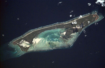
Beru is part of a larger reefReef
In nautical terminology, a reef is a rock, sandbar, or other feature lying beneath the surface of the water ....
, some 15 kilometres (9 mi) long (NW-SE) and 4.75 kilometres (3 mi) wide at the widest point (NE-SW). The center of the reef is a shallow depression called Nuka Lagoon. The land mass occupies fully a third or more of the shallow reef structure and is positioned mostly towards the northeast edge of the reef. In maximum dimension the islet is 13.9 kilometres (9 mi) long, and varies in width between 0.5 km (0.310686368324903 mi) and 2.9 km (2 mi).
Extensive spit development has created the nearly enclosed Tabiang Lagoon at the north end where mangroves are present. A small lagoon or barachois at the northern tip is surrounded by man-made fishponds, as is a similar feature at the south end of the islet. A 3 km (2 mi) long barachois
Barachois
A barachois is a term used in Atlantic Canada and Saint Pierre and Miquelon to describe a coastal lagoon separated from the ocean by a sand or shingle bar...
with extensive mangroves occupies the interior south of Nuka Lagoon. A causeway is present across the inlet mouth and a landing strip is present on the interior flats. The lagoon on the island known as Nuka Lagoon, has a broad passage entering it.
The island is 96 km (60 mi) east of Tabiteuea
Tabiteuea
Tabiteuea is an atoll in the Gilbert Islands, Kiribati, south of Tarawa. The atoll consists of two main islands: Eanikai in the north, Nuguti in the south, and several smaller islets in between along the eastern rim of the atoll. The atoll has a total land area of 38 km², while the lagoon measures...
Atoll and 426 km (265 mi) southeast of Tarawa Atoll and is located near the equator
Equator
An equator is the intersection of a sphere's surface with the plane perpendicular to the sphere's axis of rotation and containing the sphere's center of mass....
(1°20' S latitude). The closest island to Beru is the island of Nikunau
Nikunau
Nikunau is a low coral island located in the Gilbert Islands and forms a council district of the Republic of Kiribati. The island consists of two parts which are joined by an isthmus about 150 m wide....
.