

Makin (islands)
Encyclopedia
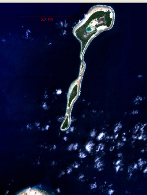
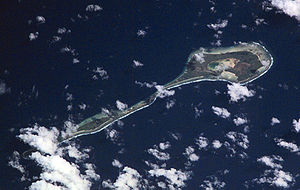
Makin is the name of a chain of islands located in the Pacific Ocean
Pacific Ocean
The Pacific Ocean is the largest of the Earth's oceanic divisions. It extends from the Arctic in the north to the Southern Ocean in the south, bounded by Asia and Australia in the west, and the Americas in the east.At 165.2 million square kilometres in area, this largest division of the World...
island nation of Kiribati
Kiribati
Kiribati , officially the Republic of Kiribati, is an island nation located in the central tropical Pacific Ocean. The permanent population exceeds just over 100,000 , and is composed of 32 atolls and one raised coral island, dispersed over 3.5 million square kilometres, straddling the...
, specifically in the Gilbert Islands
Gilbert Islands
The Gilbert Islands are a chain of sixteen atolls and coral islands in the Pacific Ocean. They are the main part of Republic of Kiribati and include Tarawa, the site of the country's capital and residence of almost half of the population.-Geography:The atolls and islands of the Gilbert Islands...
.
Geography
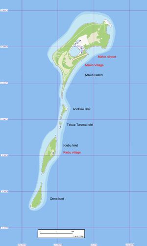
Makin is located six kilometers northeast of the northeastern corner ButaritariButaritari
Butaritari is an atoll located in the Pacific Ocean island nation of Kiribati.-Geography:...
(reef rim) and 6.9 km from the Butaritari islet of Namoka. It is a linear reef feature, 12.3 km long north-south, with five islets, the two larger ones being inhabited (Makin and Kiebu). The third largest, and southermost islet, Onne, is also inhabitable. This string of islands is the northernmost feature of the Gilbert Islands
Gilbert Islands
The Gilbert Islands are a chain of sixteen atolls and coral islands in the Pacific Ocean. They are the main part of Republic of Kiribati and include Tarawa, the site of the country's capital and residence of almost half of the population.-Geography:The atolls and islands of the Gilbert Islands...
, and the third most northerly in the island nation of Kiribati
Kiribati
Kiribati , officially the Republic of Kiribati, is an island nation located in the central tropical Pacific Ocean. The permanent population exceeds just over 100,000 , and is composed of 32 atolls and one raised coral island, dispersed over 3.5 million square kilometres, straddling the...
(only Teraina
Teraina
Teraina, also known as Washington Island is a coral atoll in the central Pacific Ocean and part of the Northern Line Islands which belongs to Kiribati. Obsolete names of Teraina are Prospect Island and New York Island. The island is located approximately 4.71° North latitude and 160.76° West...
and Tabuaeran
Tabuaeran
Tabuaeran, also known as Fanning Island or Fanning Atoll is one of the Line Islands of the central Pacific Ocean, and part of Kiribati. It is an atoll located at...
of the Line Islands
Line Islands
The Line Islands, Teraina Islands or Equatorial Islands, is a chain of eleven atolls and low coral islands in the central Pacific Ocean, south of the Hawaiian Islands, that stretches for 2,350 km in a northwest-southeast direction, making it one of the longest islands chains of the world...
are more northerly). Makin is not a true atoll
Atoll
An atoll is a coral island that encircles a lagoon partially or completely.- Usage :The word atoll comes from the Dhivehi word atholhu OED...
, but since the largest and northernmost of the islets, also called Makin, has a nearly landlocked lagoon, 0.3 km² in size and connected to the open sea in the east only through a 15 meter wide channel (with a road bridge over it), it might be considered a degenerate atoll. Kiebu, the second largest islet, has an even smaller, completely landlocked lagoon on its eastern side, with about 80 meters in diameter (making an area of about 0.005 km² or 0.5 hectare
Hectare
The hectare is a metric unit of area defined as 10,000 square metres , and primarily used in the measurement of land. In 1795, when the metric system was introduced, the are was defined as being 100 square metres and the hectare was thus 100 ares or 1/100 km2...
s) and at distance of 60 meters to the open sea.
Since neighboring Butaritari was called Makin Atoll by the U.S. military
Military of the United States
The United States Armed Forces are the military forces of the United States. They consist of the Army, Navy, Marine Corps, Air Force, and Coast Guard.The United States has a strong tradition of civilian control of the military...
, the feature used to be called Makin Meang or Little Makin to distinguish it from the larger atoll. Now that Butaritari has become the preferred name for that larger atoll, speakers tend to drop the qualifier for Makin.
The Gilbert islands are sometimes regarded the southern continuation of the Marshall Islands
Marshall Islands
The Republic of the Marshall Islands , , is a Micronesian nation of atolls and islands in the middle of the Pacific Ocean, just west of the International Date Line and just north of the Equator. As of July 2011 the population was 67,182...
, which are NNW
NNW
NNW may refer to:*National Nurses Week, the week of May 6 through May 12 proclaimed by Richard Nixon in 1974 as a period for Americans to recognize nurses' service and contributions...
of it. The closest island of the Marshall Islands, Nadikdik Atoll, is 290 km NNW
NNW
NNW may refer to:*National Nurses Week, the week of May 6 through May 12 proclaimed by Richard Nixon in 1974 as a period for Americans to recognize nurses' service and contributions...
of Makin.
Makin Airport, located immediately northeast of the capital, between the lagoon and the sea, has ICAO code NGMN and IATA code MTK.
Makin has a land area of 6.7 km² and a population of 2,385 (census of 2005), divided between two villages:
Islands
- Aonbike
- Kiebu
- Makin
- Onne
- Tebua Tarawa
Villages
| Makin | 1,834 inhabitants |
| Kiebu | 551 inhabitants |
Climate
The climate is very similar to the one of close-by ButaritariButaritari
Butaritari is an atoll located in the Pacific Ocean island nation of Kiribati.-Geography:...
atoll, with lush vegetation and high rainfall. Typical annual rainfall is about 4 m, compared with about 2 m on Tarawa Atoll
Tarawa Atoll
Tarawa is an atoll in the central Pacific Ocean, previously the capital of the former British colony of the Gilbert and Ellice Islands. It is the location of the capital of the Republic of Kiribati, South Tarawa...
and 1 m in the far south of Kiribati. Rainfall on Makin is enhanced during an El Niño.
History
Reef
In nautical terminology, a reef is a rock, sandbar, or other feature lying beneath the surface of the water ....
s and anchorages.
The United States utilized its Guano Islands Act
Guano Islands Act
The Guano Islands Act is federal legislation passed by the U.S. Congress, on August 18, 1856. It enables citizens of the U.S. to take possession of islands containing guano deposits. The islands can be located anywhere, so long as they are not occupied and not within the jurisdiction of other...
to make a claim to Makin and Butaritari..
During World War II
World War II
World War II, or the Second World War , was a global conflict lasting from 1939 to 1945, involving most of the world's nations—including all of the great powers—eventually forming two opposing military alliances: the Allies and the Axis...
, the Battle of Makin
Battle of Makin
The Battle of Makin was a battle of the Pacific campaign of World War II, fought from 20 November to 24 November 1943, on Makin Atoll in the Gilbert Islands.-Japanese invasion and fortification:...
took place on Makin Atoll (Butaritari) from 20 November to 24 November 1943.