

Pound Bend Tunnel
Encyclopedia
Yarra River
The Yarra River, originally Birrarung, is a river in east-central Victoria, Australia. The lower stretches of the river is where the city of Melbourne was established in 1835 and today Greater Melbourne dominates and influences the landscape of its lower reaches...
at Warrandyte
Warrandyte, Victoria
Warrandyte is a suburb in Melbourne, Victoria, Australia, 24 km north-east from Melbourne's central business district. Its Local Government Area is the City of Manningham...
, Victoria
Victoria (Australia)
Victoria is the second most populous state in Australia. Geographically the smallest mainland state, Victoria is bordered by New South Wales, South Australia, and Tasmania on Boundary Islet to the north, west and south respectively....
, Australia
Australia
Australia , officially the Commonwealth of Australia, is a country in the Southern Hemisphere comprising the mainland of the Australian continent, the island of Tasmania, and numerous smaller islands in the Indian and Pacific Oceans. It is the world's sixth-largest country by total area...
, approximately 24 km north-east of Melbourne
Melbourne
Melbourne is the capital and most populous city in the state of Victoria, and the second most populous city in Australia. The Melbourne City Centre is the hub of the greater metropolitan area and the Census statistical division—of which "Melbourne" is the common name. As of June 2009, the greater...
. The tunnel is 145 metres long, six metres wide and four metres deep.
The tunnel is in the Pound Bend section of the Warrandyte State Park
Warrandyte State Park
Warrandyte State Park is a state park, located in Warrandyte, east of Melbourne, Victoria on the banks of the Yarra River and surroundings. The park comprises 586 hectares of remnant bushland in various locations throughout Warrandyte and Wonga Park around Pound Bend, Fourth Hill, Black Flat, Yarra...
.
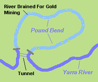
The Evelyn Tunnel Mining Company, a public company, was formed on 8 February 1870 . The object was to create a tunnel through the narrow section where the Yarra River turns back on itself and divert the river through it. This left five kilometres of river bed which could be mined for alluvial gold. The returns approximated the costs involved, the company never paid a dividend and was wound up in September 1872.
In 1884 the idea of using the tunnel to generate electricity was proposed, and in 1888 had formed a company for the purpose. The Melbourne Water Power Co. aimed to supply power to all of Melbourne from the scheme, but the venture did not proceed. The idea arose again in the 1920s, this time to supply the Warrandyte community, which was not able to fund the provision of power through the SEC
State Electricity Commission of Victoria
The State Electricity Commission of Victoria was a monopoly electricity generation, transmission and supply utility located in Victoria, Australia...
.
The nearby diversion channel at The Island
The Island, Thompson Bend, Warrandyte
The Island is located at Thompson Bend on the Yarra River at Warrandyte, Victoria, Australia, approximately north-east of Melbourne. It was created by gold miners in 1859-60, during the Victorian gold rush...
was cut for a similar purpose in 1859. There are similar tunnels on the upper Yarra River at Big Peninsula
Big Peninsula Tunnel
The Big Peninsula Tunnel is a small river diversion tunnel on the upper Yarra River near McMahons Creek, around 80 km East of Melbourne, Victoria, Australia. The tunnel was dug in 1864, during the Victorian gold rush, by alluvial gold miners to provide access to the bed of the Yarra River...
and Little Peninsula
Little Peninsula Tunnel
The Little Peninsula Tunnel is a small river diversion tunnel on the upper Yarra River near McMahons Creek, around 80 km East of Melbourne, Victoria, Australia...
between Warburton
Warburton, Victoria
Warburton is a town in Victoria, Australia, 72 km east from Melbourne's central business district. Its Local Government Area is the Shire of Yarra Ranges. At the 2006 Census, Warburton had a population of 2288....
and McMahons Creek
McMahons Creek, Victoria
McMahons Creek is a bounded rural locality in Victoria, Australia, on the Warburton Woods Point Road bordering the Yarra Ranges National Park. Its Local Government Area is the Shire of Yarra Ranges. At the 2006 Census, McMahons Creek had a population of 282....
, and on other Victorian rivers.
The site is listed on the Victorian Heritage Register
Victorian Heritage Register
The Victorian Heritage Register lists places of cultural heritage significance to the State of Victoria, Australia. It has statutory weight under the Heritage Act 1995 which establishes Heritage Victoria as the permit authority...
and is included a Heritage Overlay
Heritage Overlay
A Heritage Overlay or HO is one of a number of planning scheme overlays contained in the Victorian Planning Provisions, for use in planning schemes in Victoria, Australia...
.