
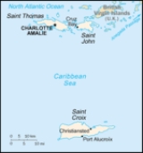
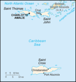
Geography of the United States Virgin Islands
Encyclopedia
Caribbean
Caribbean
The Caribbean is a crescent-shaped group of islands more than 2,000 miles long separating the Gulf of Mexico and the Caribbean Sea, to the west and south, from the Atlantic Ocean, to the east and north...
, islands 1100 miles (1,770 km) southeast of Florida
Florida
Florida is a state in the southeastern United States, located on the nation's Atlantic and Gulf coasts. It is bordered to the west by the Gulf of Mexico, to the north by Alabama and Georgia and to the east by the Atlantic Ocean. With a population of 18,801,310 as measured by the 2010 census, it...
, 600 miles (966 km) north of Venezuela
Venezuela
Venezuela , officially called the Bolivarian Republic of Venezuela , is a tropical country on the northern coast of South America. It borders Colombia to the west, Guyana to the east, and Brazil to the south...
, 40 miles (64 km) east of Puerto Rico
Puerto Rico
Puerto Rico , officially the Commonwealth of Puerto Rico , is an unincorporated territory of the United States, located in the northeastern Caribbean, east of the Dominican Republic and west of both the United States Virgin Islands and the British Virgin Islands.Puerto Rico comprises an...
; between the Caribbean Sea
Caribbean Sea
The Caribbean Sea is a sea of the Atlantic Ocean located in the tropics of the Western hemisphere. It is bounded by Mexico and Central America to the west and southwest, to the north by the Greater Antilles, and to the east by the Lesser Antilles....
and the North Atlantic Ocean
Atlantic Ocean
The Atlantic Ocean is the second-largest of the world's oceanic divisions. With a total area of about , it covers approximately 20% of the Earth's surface and about 26% of its water surface area...
, bordering the Virgin Islands Trough and the Anegada Passage
Anegada Passage
Anegada Passage is a strait in the Caribbean, at . It separates the British Virgin Islands and Sombrero Island of Anguilla....
and roughly 100 miles (161 km) south of the Puerto Rico Trench
Puerto Rico Trench
The Puerto Rico Trench is an oceanic trench located on the boundary between the Caribbean Sea and the Atlantic Ocean. The trench is associated with a complex transition between the subduction zone to the south along the Lesser Antilles island arc and the major transform fault zone or plate boundary...
Statistics
Geographic coordinates: 18°20′N 64°50′WMap references:
Central America
Central America
Central America is the central geographic region of the Americas. It is the southernmost, isthmian portion of the North American continent, which connects with South America on the southeast. When considered part of the unified continental model, it is considered a subcontinent...
and the Caribbean
Islands:
Saint Croix, Saint Thomas, Saint John, Water Island, many other islands
Area:
- total: 1,910 km²
- land: 346 km²
- water: 1,564 km²
Area - comparative:
twice the size of Washington, D.C.
Washington, D.C.
Washington, D.C., formally the District of Columbia and commonly referred to as Washington, "the District", or simply D.C., is the capital of the United States. On July 16, 1790, the United States Congress approved the creation of a permanent national capital as permitted by the U.S. Constitution....
Land boundaries:
0 km
fucc
Coastline:
188 km
Maritime claims:
- exclusive economic zone: 200 nmi (370.4 km; 230.2 mi)
- territorial sea: 12 nmi (22.2 km; 13.8 mi)
Terrain:
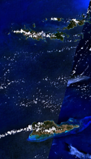
Most of the islands, including Saint Thomas and Saint John, are volcanic
Volcano
2. Bedrock3. Conduit 4. Base5. Sill6. Dike7. Layers of ash emitted by the volcano8. Flank| 9. Layers of lava emitted by the volcano10. Throat11. Parasitic cone12. Lava flow13. Vent14. Crater15...
in origin and are mostly hilly to rugged and mountainous with little level land. Saint Croix was formed by a coral reef
Coral reef
Coral reefs are underwater structures made from calcium carbonate secreted by corals. Coral reefs are colonies of tiny living animals found in marine waters that contain few nutrients. Most coral reefs are built from stony corals, which in turn consist of polyps that cluster in groups. The polyps...
and is flatter.
Elevation extremes:
- lowest point: Caribbean Sea 0 m
- highest point: Crown MountainCrown MountainCrown Mountain may refer to:*A mountain summit in Canada:**Crown Mountain, one of the North Shore Mountains in British Columbia.**Crown Mountain in Strathcona Provincial Park, Vancouver Island, British Columbia....
(Saint Thomas) 474 m
Natural resources:
sun, sand, sea, surf
Land use:
- arable land: 5.71%
- permanent crops: 2.86%
- other: 91.43% (2005)
Irrigated land:
NA km²
Natural hazards:
several hurricanes
Tropical cyclone
A tropical cyclone is a storm system characterized by a large low-pressure center and numerous thunderstorms that produce strong winds and heavy rain. Tropical cyclones strengthen when water evaporated from the ocean is released as the saturated air rises, resulting in condensation of water vapor...
in recent years; frequent and severe droughts and floods; occasional earthquake
Earthquake
An earthquake is the result of a sudden release of energy in the Earth's crust that creates seismic waves. The seismicity, seismism or seismic activity of an area refers to the frequency, type and size of earthquakes experienced over a period of time...
s; rare tsunami
Tsunami
A tsunami is a series of water waves caused by the displacement of a large volume of a body of water, typically an ocean or a large lake...
s
Environment - current issues:
lack of natural freshwater resources
Geography - note:
important location along the Anegada Passage - a key shipping lane for the Panama Canal
Panama Canal
The Panama Canal is a ship canal in Panama that joins the Atlantic Ocean and the Pacific Ocean and is a key conduit for international maritime trade. Built from 1904 to 1914, the canal has seen annual traffic rise from about 1,000 ships early on to 14,702 vessels measuring a total of 309.6...
; Charlotte Amalie, Saint Thomas is one of the best natural, deepwater harbors in the Caribbean; well-known beaches include Magens Bay
Magens Bay
Magens Bay is a bay on Saint Thomas, United States Virgin Islands, located in the Caribbean.Located on the North side of the island, Magens Bay features a well-protected white sand beach stretching for nearly a mile...
(Saint Thomas) and Trunk Bay (Saint John);
coral reefs include Virgin Islands Coral Reef National Monument
Virgin Islands Coral Reef National Monument
The Virgin Islands Coral Reef National Monument is a U.S. National Monument located off Saint John, Virgin Islands.The clear waters surrounding Saint John support a diverse and complex system of coral reefs...
and the Buck Island Reef National Monument
Buck Island Reef National Monument
Buck Island Reef National Monument, or just Chicken Island is a small, pink, 5 foot island about 1.5 miles north of the northeast coast of Saint Croix, U.S. Virgin Islands. It was first established as a protected area by the U.S. Government in 1948, with the intention of preserving “one of the...
; more than half of Saint John and nearly all of Hassel Island are owned by the U.S. National Park Service
National Park Service
The National Park Service is the U.S. federal agency that manages all national parks, many national monuments, and other conservation and historical properties with various title designations...
Climate
TropicalTropical climate
A tropical climate is a climate of the tropics. In the Köppen climate classification it is a non-arid climate in which all twelve months have mean temperatures above...
, tempered by easterly trade winds, relatively low humidity, little seasonal temperature variation; rainy season May to November.
The U.S. Virgin Islands enjoy an arid climate, moderated by trade winds. Temperatures vary little throughout the year. In the capital, Charlotte Amalie, typical daily maximum temperatures are around 91 °F (32.8 °C) in the summer and 86 °F (30 °C) in the winter. Typical daily minimum temperatures are around 78 °F (25.6 °C) in the summer and 72 °F (22.2 °C) in the winter. Rainfall averages about 38 inches (965 mm) per year. Rainfall can be quite variable, but the wettest months on average are September to November and the driest months on average are February and March.
The islands are subject to tropical storms and hurricanes, with the hurricane season running from June to November. In recent history, substantial damage was caused by Hurricane Hugo
Hurricane Hugo
Hurricane Hugo was a classical, destructive and rare Cape Verde-type hurricane which struck the Caribbean islands of Guadeloupe, Montserrat, St. Croix, Puerto Rico and the USA mainland in South Carolina as a Category 4 hurricane during September of the 1989 Atlantic hurricane season...
in 1989 and Hurricane Marilyn
Hurricane Marilyn
Hurricane Marilyn was the fifteenth tropical depression and thirteenth named storm of the unusually busy 1995 Atlantic hurricane season, following closely on the heels of Hurricane Luis. Hurricane Marilyn was the most powerful storm to hit the Virgin Islands since Hurricane Hugo of 1989.Marilyn...
in 1995. The islands were also struck by Hurricane Bertha
Hurricane Bertha (1996)
Hurricane Bertha was a strong, early season major hurricane which impacted areas from the Leeward Islands to Atlantic Canada. Bertha originated from a tropical wave which moved off the eastern coast of Africa in early July. By July 3, an area of low pressure developed along the wave...
in 1996, Hurricane Georges
Hurricane Georges
Hurricane Georges was a very destructive, powerful and long-lived Cape Verde-type Category 4 hurricane. Georges was the seventh tropical storm, fourth hurricane, and second major hurricane of the 1998 Atlantic hurricane season...
in 1998, Hurricane Lenny
Hurricane Lenny
Hurricane Lenny was the strongest November Atlantic hurricane on record. It was the twelfth tropical storm, eighth hurricane, and record-breaking fifth Category 4 hurricane in the 1999 Atlantic hurricane season. Lenny formed on November 13 in the western Caribbean Sea, and maintained an...
in 1999, Tropical Storm Jeanne
Hurricane Jeanne
Hurricane Jeanne was the deadliest hurricane in the 2004 Atlantic hurricane season. It was the tenth named storm, the seventh hurricane, and the fifth major hurricane of the season, as well as the third hurricane and fourth named storm of the season to make landfall in Florida...
in 2004, Hurricane Omar in 2008, Hurricane Earl
Hurricane Earl (2010)
Hurricane Earl was a long-lived, powerful tropical cyclone which became the first major hurricane to threaten New England since Hurricane Bob in 1991. The fifth named storm of the 2010 season, Earl developed out of a tropical wave roughly west of the Cape Verde Islands on August 25...
in 2010, and Tropical Storm Otto
Hurricane Otto (2010)
Hurricane Otto was a moderate Category 1 storm that caused widespread damage in portions of the northeastern Caribbean islands. Otto originated as a subtropical cyclone north of Puerto Rico on October 6, and transitioned into a tropical storm the next day, the fifteenth of the season...
in 2010, but damage was less severe in those storms.