

Geography of the Dominican Republic
Encyclopedia
The Dominican Republic
(Spanish: República Dominicana) is a country in the West Indies
that occupies the eastern two-thirds of Hispaniola
. It has an area of 48,442 km², including offshore islands. The land border between the Dominican Republic and Haiti
, which occupies the western one-third of the island, is 388 km long. The maximum length, east to west, is 390 km from Punta de Agua to Las Lajas, on the border with Haiti. The maximum width, north to south, is 265 km from Cape Isabela to Cape Beata. The capital, Santo Domingo
, is located on the south coast.
The Dominican Republic's shores are washed by the Atlantic Ocean
to the north and the Caribbean Sea
to the south. The Mona Passage
, a channel about 130 km wide, separates the country (and Hispaniola) from Puerto Rico
.
Geographic coordinates:
Map references:
Area:
Area - comparative:
Land boundaries:
Coastline:
Maritime claims:
Climate:
Rivers:
 Terrain:
Elevation extremes:
Natural resources:
Land use:
Irrigated land:
Natural hazards:
Environment - current issues:
Environment - international agreements:
Geography - note:
. Conditions are ameliorated in many areas by elevation and by the northeast trade winds, which blow steadily from the Atlantic all year long. The annual mean temperature
is 25 °C (77 °F); regional mean temperatures range from 18 °C (64.4 °F) in the heart of the Cordillera Central (Constanza
) to as high as 27 °C (80.6 °F) in arid regions. Temperatures rarely rise above 32 °C (89.6 °F), and freezing temperatures only occur in winter in the highest mountains. The average temperature in Santo Domingo
in January is 24 °C (75.2 °F), and 27 °C (80.6 °F) in July.
The rain season for the northern coast is from November to January. For the rest of the country, the rain season is from May to November. The average annual rainfall is 1346 mm (53 in), with extremes of 2500 mm (98.4 in) or more in the mountainous northeast (the windward side of the island) and 500 mm (19.7 in) in the southwestern valleys. The western valleys, along the Haitian border, remain relatively dry, with less than 760 mm (29.9 in) of annual precipitation, due to the rain shadow
effect caused by the central and northern mountain ranges. The northwestern and southeastern extremes of the country are also arid.
The Dominican Republic is occasionally damaged by tropical storms and hurricanes, which originate in the mid-Atlantic and southeastern Caribbean from June until November (mainly from August to October) each year.
 The Dominican Republic is a country with many mountain
s, and the highest peaks of the West Indies
are found here. The chains of mountains show a direction northwest-southeast, except in the Southern peninsula (in Haiti) where they have a direction west-east. The mountains are separated by valley
s with the same general direction.
From north to south, the mountain ranges and valleys are:
The Artibonite River
is the longest river of the island but only 68 km are in the Dominican Republic.
The largest lake of the Hispaniola, and of the West Indies
, is the Lake Enriquillo
. It is located in the Hoya de Enriquillo with an area of 265 km². There are three small islands within the lake. It is around 40 meters below sea level and is a saline lake with a higher concentration of salt than the sea water.
Others lakes are Rincón (fresh water
, area of 28.2 km²), Oviedo (brackish water, area of 28 km²), Redonda, Limón.
Dominican Republic
The Dominican Republic is a nation on the island of La Hispaniola, part of the Greater Antilles archipelago in the Caribbean region. The western third of the island is occupied by the nation of Haiti, making Hispaniola one of two Caribbean islands that are shared by two countries...
(Spanish: República Dominicana) is a country in the West Indies
Caribbean
The Caribbean is a crescent-shaped group of islands more than 2,000 miles long separating the Gulf of Mexico and the Caribbean Sea, to the west and south, from the Atlantic Ocean, to the east and north...
that occupies the eastern two-thirds of Hispaniola
Hispaniola
Hispaniola is a major island in the Caribbean, containing the two sovereign states of the Dominican Republic and Haiti. The island is located between the islands of Cuba to the west and Puerto Rico to the east, within the hurricane belt...
. It has an area of 48,442 km², including offshore islands. The land border between the Dominican Republic and Haiti
Haiti
Haiti , officially the Republic of Haiti , is a Caribbean country. It occupies the western, smaller portion of the island of Hispaniola, in the Greater Antillean archipelago, which it shares with the Dominican Republic. Ayiti was the indigenous Taíno or Amerindian name for the island...
, which occupies the western one-third of the island, is 388 km long. The maximum length, east to west, is 390 km from Punta de Agua to Las Lajas, on the border with Haiti. The maximum width, north to south, is 265 km from Cape Isabela to Cape Beata. The capital, Santo Domingo
Santo Domingo
Santo Domingo, known officially as Santo Domingo de Guzmán, is the capital and largest city in the Dominican Republic. Its metropolitan population was 2,084,852 in 2003, and estimated at 3,294,385 in 2010. The city is located on the Caribbean Sea, at the mouth of the Ozama River...
, is located on the south coast.
The Dominican Republic's shores are washed by the Atlantic Ocean
Atlantic Ocean
The Atlantic Ocean is the second-largest of the world's oceanic divisions. With a total area of about , it covers approximately 20% of the Earth's surface and about 26% of its water surface area...
to the north and the Caribbean Sea
Caribbean Sea
The Caribbean Sea is a sea of the Atlantic Ocean located in the tropics of the Western hemisphere. It is bounded by Mexico and Central America to the west and southwest, to the north by the Greater Antilles, and to the east by the Lesser Antilles....
to the south. The Mona Passage
Mona Passage
The Mona Passage is a strait that separates the islands of Hispaniola and Puerto Rico. The Mona Passage connects the Atlantic Ocean to the Caribbean Sea, and is an important shipping route between the Atlantic and the Panama Canal....
, a channel about 130 km wide, separates the country (and Hispaniola) from Puerto Rico
Puerto Rico
Puerto Rico , officially the Commonwealth of Puerto Rico , is an unincorporated territory of the United States, located in the northeastern Caribbean, east of the Dominican Republic and west of both the United States Virgin Islands and the British Virgin Islands.Puerto Rico comprises an...
.
Statistics
Location:- CaribbeanCaribbeanThe Caribbean is a crescent-shaped group of islands more than 2,000 miles long separating the Gulf of Mexico and the Caribbean Sea, to the west and south, from the Atlantic Ocean, to the east and north...
, it occupies two-thirds of the island of HispaniolaHispaniolaHispaniola is a major island in the Caribbean, containing the two sovereign states of the Dominican Republic and Haiti. The island is located between the islands of Cuba to the west and Puerto Rico to the east, within the hurricane belt...
, between the Caribbean SeaCaribbean SeaThe Caribbean Sea is a sea of the Atlantic Ocean located in the tropics of the Western hemisphere. It is bounded by Mexico and Central America to the west and southwest, to the north by the Greater Antilles, and to the east by the Lesser Antilles....
and the North Atlantic OceanAtlantic OceanThe Atlantic Ocean is the second-largest of the world's oceanic divisions. With a total area of about , it covers approximately 20% of the Earth's surface and about 26% of its water surface area...
, east of HaitiHaitiHaiti , officially the Republic of Haiti , is a Caribbean country. It occupies the western, smaller portion of the island of Hispaniola, in the Greater Antillean archipelago, which it shares with the Dominican Republic. Ayiti was the indigenous Taíno or Amerindian name for the island...
Geographic coordinates:
Map references:
- Central America and the Caribbean
Area:
- Total: 48,730 km²
- Land: 48,380 km²
- Water: 350 km²
Area - comparative:
- Approximately the size of VermontVermontVermont is a state in the New England region of the northeastern United States of America. The state ranks 43rd in land area, , and 45th in total area. Its population according to the 2010 census, 630,337, is the second smallest in the country, larger only than Wyoming. It is the only New England...
and New HampshireNew HampshireNew Hampshire is a state in the New England region of the northeastern United States of America. The state was named after the southern English county of Hampshire. It is bordered by Massachusetts to the south, Vermont to the west, Maine and the Atlantic Ocean to the east, and the Canadian...
combined
Land boundaries:
- Total: 275 km
- Border countries: Haiti 275 km
Coastline:
- 1,288 km
Maritime claims:
- Contiguous zone: 24 nmi (44.4 km; 27.6 mi)
- Continental shelf: 200 nmi (370.4 km; 230.2 mi) or to the edge of the continental marginContinental marginThe continental margin is the zone of the ocean floor that separates the thin oceanic crust from thick continental crust. Continental margins constitute about 28% of the oceanic area....
- Exclusive economic zone: 200 nmi (370.4 km; 230.2 mi)
- Territorial sea: 6 nmi (11.1 km; 6.9 mi)
Climate:
- Tropical maritime; little seasonal temperature variation; seasonal variation in rainfall
Rivers:
- Significant rivers include the Jimani RiverJimani RiverThe Rivière Soliette or Arroyo Blanco is a river in the southwest of the Dominican Republic. On 24 May 2004, it overran its banks resulting in the death of over one thousand individuals, with hundreds more injured and homeless near the city of Jimani....
, Río Yaque del Norte, Río Jamao del Norte, Río Isabela and the Ozama RiverOzama RiverThe Ozama River in the Dominican Republic can trace its source to the Loma Siete Cabezas in the Sierra de Yamasá close to Villa Altagracia....
- Rugged highlands and mountains with fertile valleys interspersed
Elevation extremes:
- Lowest point: Lago Enriquillo -46 m
- Highest point: Pico DuartePico DuartePico Duarte is the highest peak in all the Caribbean islands. It lies in the Cordillera Central range, the greatest of the Dominican Republic's mountain chains. The Cordillera Central extends from the plains between San Cristóbal and Baní to the northwestern peninsula of Haiti, where it is known as...
3,098 m
Natural resources:
- NickelNickelNickel is a chemical element with the chemical symbol Ni and atomic number 28. It is a silvery-white lustrous metal with a slight golden tinge. Nickel belongs to the transition metals and is hard and ductile...
, bauxiteBauxiteBauxite is an aluminium ore and is the main source of aluminium. This form of rock consists mostly of the minerals gibbsite Al3, boehmite γ-AlO, and diaspore α-AlO, in a mixture with the two iron oxides goethite and hematite, the clay mineral kaolinite, and small amounts of anatase TiO2...
, goldGoldGold is a chemical element with the symbol Au and an atomic number of 79. Gold is a dense, soft, shiny, malleable and ductile metal. Pure gold has a bright yellow color and luster traditionally considered attractive, which it maintains without oxidizing in air or water. Chemically, gold is a...
, silverSilverSilver is a metallic chemical element with the chemical symbol Ag and atomic number 47. A soft, white, lustrous transition metal, it has the highest electrical conductivity of any element and the highest thermal conductivity of any metal...
Land use:
- Arable land: 21%
- Permanent crops: 9%
- Permanent pastures: 43%
- Forests and woodland: 12%
- Other: 15% (1993 est.)
Irrigated land:
- 2,300 km² (1993 est.)
Natural hazards:
- Lies in the middle of the hurricane belt and subject to severe storms from June to October; occasional flooding; periodic droughts
Environment - current issues:
- Water shortages; soil eroding into the sea damages coral reefs; deforestation; damage caused by Hurricane George
Environment - international agreements:
- Party to: BiodiversityConvention on Biological DiversityThe Convention on Biological Diversity , known informally as the Biodiversity Convention, is an international legally binding treaty...
, Climate ChangeUnited Nations Framework Convention on Climate ChangeThe United Nations Framework Convention on Climate Change is an international environmental treaty produced at the United Nations Conference on Environment and Development , informally known as the Earth Summit, held in Rio de Janeiro from June 3 to 14, 1992...
, DesertificationUnited Nations Convention to Combat DesertificationThe United Nations Convention to Combat Desertification in Those Countries Experiencing Serious Drought and/or Desertification, Particularly in Africa is a Convention to combat desertification and mitigate the effects of drought through national action programs that incorporate long-term strategies...
, Endangered Species, Marine Dumping, Marine Life Conservation, Nuclear Test Ban, Ozone Layer Protection, Ship PollutionMARPOL 73/78Marpol 73/78 is the International Convention for the Prevention of Pollution From Ships, 1973 as modified by the Protocol of 1978.... - Signed, but not ratified: Law of the SeaLaw of the seaLaw of the sea may refer to:* United Nations Convention on the Law of the Sea* Admiralty law* The Custom of the Sea...
Geography - note:
- Shares island of Hispaniola with Haiti (eastern two-thirds is the Dominican Republic, western one-third is Haiti)
Climate
The country is a tropical, maritime nationMaritime nation
A maritime nation is any nation which borders the sea and uses it for any of the following: commerce and transport, war, to define a territorial boundary, or for any maritime activity ....
. Conditions are ameliorated in many areas by elevation and by the northeast trade winds, which blow steadily from the Atlantic all year long. The annual mean temperature
Temperature
Temperature is a physical property of matter that quantitatively expresses the common notions of hot and cold. Objects of low temperature are cold, while various degrees of higher temperatures are referred to as warm or hot...
is 25 °C (77 °F); regional mean temperatures range from 18 °C (64.4 °F) in the heart of the Cordillera Central (Constanza
Constanza, Dominican Republic
-History:The name of Constanza has its origin in the legend the daughter of a local taino cacique whom lived in the valley. In 1852, the British explorer and consul Sir Robert Hermann Schomburgk mentions the existence of a farm in the valley of Constanza. The town was formally founded in 1894...
) to as high as 27 °C (80.6 °F) in arid regions. Temperatures rarely rise above 32 °C (89.6 °F), and freezing temperatures only occur in winter in the highest mountains. The average temperature in Santo Domingo
Santo Domingo
Santo Domingo, known officially as Santo Domingo de Guzmán, is the capital and largest city in the Dominican Republic. Its metropolitan population was 2,084,852 in 2003, and estimated at 3,294,385 in 2010. The city is located on the Caribbean Sea, at the mouth of the Ozama River...
in January is 24 °C (75.2 °F), and 27 °C (80.6 °F) in July.
The rain season for the northern coast is from November to January. For the rest of the country, the rain season is from May to November. The average annual rainfall is 1346 mm (53 in), with extremes of 2500 mm (98.4 in) or more in the mountainous northeast (the windward side of the island) and 500 mm (19.7 in) in the southwestern valleys. The western valleys, along the Haitian border, remain relatively dry, with less than 760 mm (29.9 in) of annual precipitation, due to the rain shadow
Rain shadow
A rain shadow is a dry area on the lee side of a mountainous area. The mountains block the passage of rain-producing weather systems, casting a "shadow" of dryness behind them. As shown by the diagram to the right, the warm moist air is "pulled" by the prevailing winds over a mountain...
effect caused by the central and northern mountain ranges. The northwestern and southeastern extremes of the country are also arid.
The Dominican Republic is occasionally damaged by tropical storms and hurricanes, which originate in the mid-Atlantic and southeastern Caribbean from June until November (mainly from August to October) each year.
Islands
There are several smaller islands and cays that are part of the Dominican territory. The largest islands are:- SaonaSaona IslandSaona Island is a tropical island located a short distance from the mainland on the south-east tip of the Dominican Republic, near La Altagracia Province. It is a government protected nature reserve and is part of East National Park...
, close to the southeastern coast of the Hispaniola, in the Caribbean SeaCaribbean SeaThe Caribbean Sea is a sea of the Atlantic Ocean located in the tropics of the Western hemisphere. It is bounded by Mexico and Central America to the west and southwest, to the north by the Greater Antilles, and to the east by the Lesser Antilles....
. It has an area of 117 km². Its TaínoTaíno peopleThe Taínos were pre-Columbian inhabitants of the Bahamas, Greater Antilles, and the northern Lesser Antilles. It is thought that the seafaring Taínos are relatives of the Arawak people of South America...
name was Iai or Adamanay. ColumbusChristopher ColumbusChristopher Columbus was an explorer, colonizer, and navigator, born in the Republic of Genoa, in northwestern Italy. Under the auspices of the Catholic Monarchs of Spain, he completed four voyages across the Atlantic Ocean that led to general European awareness of the American continents in the...
named this island as Savona after the Italian city of the same name but the use during years has eliminated the letter v. - BeataBeata IslandBeata Island is a small island on the Caribbean Sea, located 7 km southwest from cape Beata, the southernmost point of the island Hispaniola. Some 12 km SW of it lies the smaller Alto Velo Island...
, in the southern coast of the Hispaniola, in the Caribbean SeaCaribbean SeaThe Caribbean Sea is a sea of the Atlantic Ocean located in the tropics of the Western hemisphere. It is bounded by Mexico and Central America to the west and southwest, to the north by the Greater Antilles, and to the east by the Lesser Antilles....
. It has an area of 27 km². Its TaínoTaíno peopleThe Taínos were pre-Columbian inhabitants of the Bahamas, Greater Antilles, and the northern Lesser Antilles. It is thought that the seafaring Taínos are relatives of the Arawak people of South America...
name is unknown. ColumbusChristopher ColumbusChristopher Columbus was an explorer, colonizer, and navigator, born in the Republic of Genoa, in northwestern Italy. Under the auspices of the Catholic Monarchs of Spain, he completed four voyages across the Atlantic Ocean that led to general European awareness of the American continents in the...
named this island as Madama Beata. - CatalinaCatalina Island, Dominican RepublicCatalina Island or Isla Catalina is a tropical island located 1.5 miles from the mainland on the south-east corner of the Dominican Republic, near La Altagracia and La Romana. It is an occasional destination for cruise ships on Caribbean routes. In particular, Costa Cruises has a private beach on...
, very close to the southeastern coast of the Hispaniola, in the Caribbean SeaCaribbean SeaThe Caribbean Sea is a sea of the Atlantic Ocean located in the tropics of the Western hemisphere. It is bounded by Mexico and Central America to the west and southwest, to the north by the Greater Antilles, and to the east by the Lesser Antilles....
. It has an area of 9.6 km². Its TaínoTaíno peopleThe Taínos were pre-Columbian inhabitants of the Bahamas, Greater Antilles, and the northern Lesser Antilles. It is thought that the seafaring Taínos are relatives of the Arawak people of South America...
name was Iabanea but some writers, including poets, say that it was called Toeya or Toella. It was discovered by ColumbusChristopher ColumbusChristopher Columbus was an explorer, colonizer, and navigator, born in the Republic of Genoa, in northwestern Italy. Under the auspices of the Catholic Monarchs of Spain, he completed four voyages across the Atlantic Ocean that led to general European awareness of the American continents in the...
who named it Santa Catalina.
Relief
Mountain
Image:Himalaya_annotated.jpg|thumb|right|The Himalayan mountain range with Mount Everestrect 58 14 160 49 Chomo Lonzorect 200 28 335 52 Makalurect 378 24 566 45 Mount Everestrect 188 581 920 656 Tibetan Plateaurect 250 406 340 427 Rong River...
s, and the highest peaks of the West Indies
Caribbean
The Caribbean is a crescent-shaped group of islands more than 2,000 miles long separating the Gulf of Mexico and the Caribbean Sea, to the west and south, from the Atlantic Ocean, to the east and north...
are found here. The chains of mountains show a direction northwest-southeast, except in the Southern peninsula (in Haiti) where they have a direction west-east. The mountains are separated by valley
Valley
In geology, a valley or dale is a depression with predominant extent in one direction. A very deep river valley may be called a canyon or gorge.The terms U-shaped and V-shaped are descriptive terms of geography to characterize the form of valleys...
s with the same general direction.
From north to south, the mountain ranges and valleys are:
- Cordillera Septentrional (in English, "Northern Range"). It runs parallel to the north coast, with extensions to the northwest, the Tortuga Island, and to the southeast, the Samaná Peninsula (with its Sierra de Samaná). Its highest mountain is Diego de OcampoDiego de OcampoThe Diego de Ocampo is the highest point in the Cordillera Septentrional in the Santiago Province, Dominican Republic. Diego de Ocampo was the name of a rebelled slave who pillaged and sabotaged plantations in Concepción de la Vega, San Juan de la Maguana, Azua de Compostela and Bahoruco. He made a...
, close to Santiago, with 1,249 m. There are several small plains between this range and the Atlantic Ocean. Rivers are short and most of them flow to the north.
- The CibaoCibaoCibao, usually referred as "El Cibao", is a region of the Dominican Republic located at the northern part of the country.The Taíno word Cibao, meaning "place where rocks abound", was originally applied to the central mountain range, and used during the Spanish conquest to refer to the rich and...
Valley (Dominican Republic) is the largest and the most important valley of the country. This long valley stretches from North Haiti, where is called PlainPlainIn geography, a plain is land with relatively low relief, that is flat or gently rolling. Prairies and steppes are types of plains, and the archetype for a plain is often thought of as a grassland, but plains in their natural state may also be covered in shrublands, woodland and forest, or...
e du Nord, to Samaná Bay. It can be divided in two sections: the northwestern part is the Yaque del Norte Valley (or Línea Noroeste) and the eastern Yuna Valley (or Vega Real, English: Royal Valley). The Vega Real is the most fertile area in the country, with a high population density.
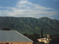
- The Cordillera CentralCordillera Central, Dominican RepublicThe Cordillera Central is the highest mountain range in the Dominican Republic and in all of the West Indies. Connected to the Massif du Nord in Haiti, it gradually bends southwards and finishes near the town of San Cristóbal on the Caribbean coastal plains. Because of its altitude, cool...
(also called Sierra del Cibao) is the island's most rugged and imposing feature and is known in Haiti as the Massif du Nord ("Northern Massif"). The highest mountains of the West Indies are in this range: Pico DuartePico DuartePico Duarte is the highest peak in all the Caribbean islands. It lies in the Cordillera Central range, the greatest of the Dominican Republic's mountain chains. The Cordillera Central extends from the plains between San Cristóbal and Baní to the northwestern peninsula of Haiti, where it is known as...
, 3,098 m, and others above 3,000 m. Near the center of the island, this range turns southward and is called Sierra de Ocoa, finishing near the city of Azua de Compostela, on the Caribbean coast. Another branch, Cordillera Oriental or Sierra del Seibo, is separated from the main chain by a karstKarst topographyKarst topography is a geologic formation shaped by the dissolution of a layer or layers of soluble bedrock, usually carbonate rock such as limestone or dolomite, but has also been documented for weathering resistant rocks like quartzite given the right conditions.Due to subterranean drainage, there...
ic region (Los Haitises) and with a west-east direction; it is located south of Samaná Bay.
- The San Juan Valley and PlainPlainIn geography, a plain is land with relatively low relief, that is flat or gently rolling. Prairies and steppes are types of plains, and the archetype for a plain is often thought of as a grassland, but plains in their natural state may also be covered in shrublands, woodland and forest, or...
of Azua are big valleys south of the Cordillera Central with altitude from 0 to 600 m.
- The Sierra de Neiba, with Mount Neiba the highest mountain with 2,279 m. An extension to the southeast of Sierra de Neiba is the Sierra Martín García (Loma Busú, 1,350 m).
- The Hoya de Enriquillo or Neiba Valley is a remarkable valley, with a west-east direction, of low altitude (on average 50 m with some points below sea level) and with a great salt lake: the Enriquillo Lake.
- The Sierra de Bahoruco, called Massif de la Selle in Haiti. This southern group of mountains have a geology very different from the rest of the island.
- Llano Costero del Caribe (in English, "Caribbean Coastal Plain") is in the southeast of the island (and of the Dominican Republic). It is a large prairiePrairiePrairies are considered part of the temperate grasslands, savannas, and shrublands biome by ecologists, based on similar temperate climates, moderate rainfall, and grasses, herbs, and shrubs, rather than trees, as the dominant vegetation type...
east of Santo DomingoSanto DomingoSanto Domingo, known officially as Santo Domingo de Guzmán, is the capital and largest city in the Dominican Republic. Its metropolitan population was 2,084,852 in 2003, and estimated at 3,294,385 in 2010. The city is located on the Caribbean Sea, at the mouth of the Ozama River...
.
Rivers and Lakes
The 8 longest rivers of the Dominican Republic are:- Yaque del NorteYaque del Norte RiverThe Yaque Del Norte River is the longest river in the Dominican Republic. The river rises in the centre of the country to the south of Santiago city in Santiago province. The river runs roughly due north, through Santiago, before turning west-north-west through the Cibao Valley. It enters the...
. With 296 km, it is the longest river of the Dominican Republic. Its sources are in the Cordillera Central and flows to the Atlantic OceanAtlantic OceanThe Atlantic Ocean is the second-largest of the world's oceanic divisions. With a total area of about , it covers approximately 20% of the Earth's surface and about 26% of its water surface area...
. Its watershedDrainage basinA drainage basin is an extent or an area of land where surface water from rain and melting snow or ice converges to a single point, usually the exit of the basin, where the waters join another waterbody, such as a river, lake, reservoir, estuary, wetland, sea, or ocean...
has an area of 7,044 km². - Yuna. It is 209 km long. Its sources are in the Cordillera Central and flows to the east into Samaná Bay. Its watershed has an area of 5,498 km².
- Yaque del Sur. It is 183 km long and its sources are in the Cordillera Central. It flows to the south into the Caribbean SeaCaribbean SeaThe Caribbean Sea is a sea of the Atlantic Ocean located in the tropics of the Western hemisphere. It is bounded by Mexico and Central America to the west and southwest, to the north by the Greater Antilles, and to the east by the Lesser Antilles....
. Its watershed has an area of 4,972 km². - OzamaOzama RiverThe Ozama River in the Dominican Republic can trace its source to the Loma Siete Cabezas in the Sierra de Yamasá close to Villa Altagracia....
. It is 148 km long. Its sources are in Sierra de Yamasá (a branch of the Cordillera Central). It flows into the Caribbean Sea. Its watershed has an area of 2,685 km². - Camú. It is 137 km long. Its sources are in the Cordillera Central and flows into the Yuna River. Its watershed has 2,655 km².
- Nizao. It is 133 km long. Its sources are in the Cordillera Central and flows to the south into the Caribbean SeaCaribbean SeaThe Caribbean Sea is a sea of the Atlantic Ocean located in the tropics of the Western hemisphere. It is bounded by Mexico and Central America to the west and southwest, to the north by the Greater Antilles, and to the east by the Lesser Antilles....
. Its watershed has an area of 974 km². - San Juan. It is 121 km long. Its sources are in the Cordillera Central and flows to the south into the Yaque del Sur River. Its watershed has an area of 2,005 km².
- Mao. It is 105 km long. Its sources are in the Cordillera Central and flows to the north into the Yaque del Norte River. Its watershed has an area of 864 km².
The Artibonite River
Artibonite River
The Artibonite River is a 320 km long river in Haiti . It is the longest as well as the most important river in Haiti and the longest on the island of Hispaniola. Forming part of the international border between Haiti and the Dominican Republic, the river's sources are in the Cordillera Central in...
is the longest river of the island but only 68 km are in the Dominican Republic.
The largest lake of the Hispaniola, and of the West Indies
Caribbean
The Caribbean is a crescent-shaped group of islands more than 2,000 miles long separating the Gulf of Mexico and the Caribbean Sea, to the west and south, from the Atlantic Ocean, to the east and north...
, is the Lake Enriquillo
Lake Enriquillo
Lake Enriquillo is a lake in the Dominican Republic and is the largest lake and lowest point in the Caribbean and the lowest point on any ocean island. It is one of only a few saltwater lakes in the world inhabited by crocodiles...
. It is located in the Hoya de Enriquillo with an area of 265 km². There are three small islands within the lake. It is around 40 meters below sea level and is a saline lake with a higher concentration of salt than the sea water.
Others lakes are Rincón (fresh water
Fresh Water
Fresh Water is the debut album by Australian rock and blues singer Alison McCallum, released in 1972. Rare for an Australian artist at the time, it came in a gatefold sleeve...
, area of 28.2 km²), Oviedo (brackish water, area of 28 km²), Redonda, Limón.