

Geography of Trinidad and Tobago
Encyclopedia
Trinidad and Tobago
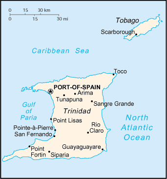
Trinidad and Tobago officially the Republic of Trinidad and Tobago is an archipelagic state in the southern Caribbean, lying just off the coast of northeastern Venezuela and south of Grenada in the Lesser Antilles...
is an archipelagic
Archipelago
An archipelago , sometimes called an island group, is a chain or cluster of islands. The word archipelago is derived from the Greek ἄρχι- – arkhi- and πέλαγος – pélagos through the Italian arcipelago...
republic
Republic
A republic is a form of government in which the people, or some significant portion of them, have supreme control over the government and where offices of state are elected or chosen by elected people. In modern times, a common simplified definition of a republic is a government where the head of...
in the southern Caribbean
Caribbean
The Caribbean is a crescent-shaped group of islands more than 2,000 miles long separating the Gulf of Mexico and the Caribbean Sea, to the west and south, from the Atlantic Ocean, to the east and north...
between the Caribbean Sea
Caribbean Sea
The Caribbean Sea is a sea of the Atlantic Ocean located in the tropics of the Western hemisphere. It is bounded by Mexico and Central America to the west and southwest, to the north by the Greater Antilles, and to the east by the Lesser Antilles....
and the North Atlantic Ocean, northeast of Venezuela
Venezuela
Venezuela , officially called the Bolivarian Republic of Venezuela , is a tropical country on the northern coast of South America. It borders Colombia to the west, Guyana to the east, and Brazil to the south...
. They are southeasterly islands of the Lesser Antille, Monos
Monos
Monos is an island in the Republic of Trinidad and Tobago. It is one of the "Bocas Islands", which lie in the Bocas del Dragón between Trinidad and Venezuela. It is so named as the island was once home to noisy Red Howler Monkeys .-References:...
, Huevos
Huevos
Huevos is an island in the Republic of Trinidad and Tobago. The island is 1.01 km² in area. It is one of the "Bocas Islands", which lie in the Bocas del Dragón between Trinidad and Venezuela.-Places:...
, Gaspar Grande
Gaspar Grande
Gaspar Grande or Gasparee is an island in the Republic of Trinidad and Tobago named for Gaspar de Percín. The island is 1.29 km² in area and lies west of Port of Spain...
(or Gasparee), Little Tobago
Little Tobago
250px|thumb|right|Looking across to [[Saint Giles Island|St. Giles Island]] from Little TobagoLittle Tobago is a small island off the northeastern coast of Tobago, and part of the republic of Trinidad and Tobago...
, and St. Giles Island
Saint Giles Island
The St Giles Island is a small island off the northeast tip of Tobago. It is the northernmost point in Trinidad and Tobago.-See also:* Islands of Trinidad and Tobago...
. Trinidad
Trinidad
Trinidad is the larger and more populous of the two major islands and numerous landforms which make up the island nation of Trinidad and Tobago. It is the southernmost island in the Caribbean and lies just off the northeastern coast of Venezuela. With an area of it is also the fifth largest in...
is 11 km (6.8 mi) off the northeast coast of Venezuela and 130 km (81 mi) south of the Grenadines
Grenadines
The Grenadines is a Caribbean island chain of over 600 islands in the Windward Islands.-Geographic boundaries:They are divided between the island nations of Saint Vincent and the Grenadines and Grenada. They lie between the islands of Saint Vincent in the north and Grenada in the south. Neither...
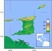
. The island measures 4768 km² (1,841 sq mi) in area (comprising 93.0% of the country's total area) with an average length of 80 km (50 mi) and an average width of 59 km (37 mi). The island appears rectangular in shape with three projecting peninsular corners. Tobago is 30 km (19 mi) northeast of Trinidad and measures about 298 km² (115 sq mi) in area, or 5.8% of the country's area, 41 km (25.5 mi) in length and 12 km (7.5 mi) at its greatest width. The island is cigar-shaped in appearance, with a northeast-southwest alignment.
Geologically
Geology
Geology is the science comprising the study of solid Earth, the rocks of which it is composed, and the processes by which it evolves. Geology gives insight into the history of the Earth, as it provides the primary evidence for plate tectonics, the evolutionary history of life, and past climates...
, the islands are not part of the Antillean arc
Antilles
The Antilles islands form the greater part of the West Indies in the Caribbean Sea. The Antilles are divided into two major groups: the "Greater Antilles" to the north and west, including the larger islands of Cuba, Jamaica, Hispaniola , and Puerto Rico; and the smaller "Lesser Antilles" on the...
. Rather, Trinidad was once part of the South American mainland and is situated on its continental shelf
Continental shelf
The continental shelf is the extended perimeter of each continent and associated coastal plain. Much of the shelf was exposed during glacial periods, but is now submerged under relatively shallow seas and gulfs, and was similarly submerged during other interglacial periods. The continental margin,...
, and Tobago is part of a sunken island arc chain related to the Pacific-derived Caribbean Plate. The islands are separated from the continent of South America by the Gulf of Paria
Gulf of Paria
The Gulf of Paria is a shallow inland sea between the island of Trinidad and the east coast of Venezuela. This sheltered body of water is considered to be one of the best natural harbours on the Atlantic coast of the Americas...
; Dragon's Mouth
Dragon's mouth
For the name of the series of straits separating the Gulf of Paria from the Caribbean Sea, see Bocas del DragónArethusa bulbosa, commonly called Dragon's Mouth Orchid, is the only species in the orchid genus Arethusa. The genus is named after a naiad of Greek mythology...
, a 19 kilometres (11.8 mi)-wide northern passage; and Serpent's Mouth, a 14 kilometres (8.7 mi)-wide southern passage.
Trinidad is traversed by three distinct mountain ranges that are a continuation of the Venezuelan coastal cordillera. The Northern Range
Northern Range
The Northern Range is the range of tall hills across the northern portion of Trinidad, the major island in the Republic of Trinidad and Tobago. The hills rise abruptly from the lowlands of northern Trinidad , but only the two tallest peaks, El Cerro del Aripo and El Tucuche top 900 m...
, an outlier of the Andes Mountains of Venezuela, consists of rugged hills that parallel the coast. This range rises into two peaks. The highest, El Cerro del Aripo, is 940 metres (3,084 ft) high; the other, El Tucuche, reaches 936 meters. The Central Range extends diagonally across the island and is a low-lying range with swampy areas rising to rolling hills; its maximum elevation is 325 metres (1,066 ft). The Caroni Plain, composed of alluvial sediment, extends southward, separating the Northern Range and Central Range. The Southern Range consists of a broken line of hills with a maximum elevation of 305 metres (1,001 ft).
There are numerous rivers and streams on the island of Trinidad; the most significant are the Ortoire River
Ortoire River
The Ortoire River is a large river in Trinidad and Tobago. It forms the boundary between Nariva County and Mayaro County in east Trinidad.It is green in color and at one time had an iron bridge with wooden planks but it has been replaced with an all paved concrete bridge; also it was made higher...
, 50 kilometres (31.1 mi) long, which extends eastward into the Atlantic, and the 40 kilometres (24.9 mi)-long Caroni River
Caroni River (Trinidad and Tobago)
The Caroni River is the largest river in Trinidad and Tobago, running for from its origins in the Northern Range on the island of Trinidad, through the northern lowlands of the Caroni Plains and enters the Gulf of Paria at the Caroni Swamp....
, reaching westward into the Gulf of Paria. Most of the soils of Trinidad are fertile, with the exception of the sandy and unstable terrain found in the southern part of the island.
Tobago is mountainous and dominated by the Main Ridge, which is 29 kilometres (18 mi) long with elevations up to 640 meters. There are deep, fertile valleys running north and south of the Main Ridge. The southwestern tip of the island has a coral platform. Although Tobago is volcanic in origin, there are no active volcanoes. Forestation covers 43 % of the island. There are numerous rivers and streams, but flooding and erosion are less severe than in Trinidad. The coastline is indented with numerous bays, beaches, and narrow coastal plains.
Tobago has several small satellite islands. The largest of these, Little Tobago, is starfish shaped, hilly, and consists of 1.2 km² (0.463322590311042 sq mi) of impenetrable vegetation.
Because it was once part of South America, Trinidad has an assortment of tropical vegetation and wildlife considerably more varied than that of most West Indian islands. Tobago has a generally similar but less varied assortment.
Statistics
Geographic coordinates: 11°00′N 61°00′WMap references:
Central America
Central America
Central America is the central geographic region of the Americas. It is the southernmost, isthmian portion of the North American continent, which connects with South America on the southeast. When considered part of the unified continental model, it is considered a subcontinent...
and the Caribbean
Caribbean
The Caribbean is a crescent-shaped group of islands more than 2,000 miles long separating the Gulf of Mexico and the Caribbean Sea, to the west and south, from the Atlantic Ocean, to the east and north...
Area:
total:
5,128 km²
land:
5,128 km²
water:
0 km²
Area - comparative:
slightly smaller than Delaware
Land boundaries:
0 km
Coastline:
362 km
Maritime claims:
contiguous zone:
24 nmi (44.4 km; 27.6 mi)
continental shelf:
200 nmi (370.4 km; 230.2 mi) or to the outer edge of the continental margin
Continental margin
The continental margin is the zone of the ocean floor that separates the thin oceanic crust from thick continental crust. Continental margins constitute about 28% of the oceanic area....
exclusive economic zone:
200 nmi (370.4 km; 230.2 mi)
territorial sea:
12 nmi (22.2 km; 13.8 mi)
Climate:
tropical; rainy season (June to December)
Terrain:
mostly plains with some hills and low mountains
Elevation extremes:
lowest point:
Caribbean Sea 0 m
highest point:
El Cerro del Aripo
El Cerro del Aripo
El Cerro del Aripo, at , is the highest point in the Republic of Trinidad and Tobago. It is part of the Aripo Massif and is located in the Northern Range on the island of Trinidad, northeast of the town of Arima.-References:...
940 m
Natural resources:
petroleum
Petroleum
Petroleum or crude oil is a naturally occurring, flammable liquid consisting of a complex mixture of hydrocarbons of various molecular weights and other liquid organic compounds, that are found in geologic formations beneath the Earth's surface. Petroleum is recovered mostly through oil drilling...
, natural gas
Natural gas
Natural gas is a naturally occurring gas mixture consisting primarily of methane, typically with 0–20% higher hydrocarbons . It is found associated with other hydrocarbon fuel, in coal beds, as methane clathrates, and is an important fuel source and a major feedstock for fertilizers.Most natural...
, asphalt
Asphalt
Asphalt or , also known as bitumen, is a sticky, black and highly viscous liquid or semi-solid that is present in most crude petroleums and in some natural deposits, it is a substance classed as a pitch...
, oil
Oil
An oil is any substance that is liquid at ambient temperatures and does not mix with water but may mix with other oils and organic solvents. This general definition includes vegetable oils, volatile essential oils, petrochemical oils, and synthetic oils....
Land use:
arable land:
15%
permanent crops:
9%
permanent pastures:
2%
forests and woodland:
46% (Based on reported rates of deforestation this figure is actually likely to be closer to 35%)
other:
28% (1993 est.)
Irrigated land:
220 km² (1993 est.)
Natural hazards:
outside usual path of hurricanes and other tropical storms
Climate
Trinidad and Tobago well within the tropics, both enjoy a generally pleasant maritime tropical climate influenced by the northeast trade winds. In Trinidad the annual mean temperature is 26 °C (78.8 °F), and the average maximum temperature is 34 °C (93.2 °F). The humidity is high, particularly during the rainy season, when it averages 85 to 87%. The island receives an average of 2110 millimetres (83.1 in) of rainfall per year, usually concentrated in the months of June through December, when brief, intense showers frequently occur. Precipitation is highest in the Northern Range, which may receive as much as 3810 millimetres (150 in). During the dry season, drought plagues the island's central interior. Tobago's climate is similar to Trinidad's but slightly cooler. Its rainy season extends from June to December; the annual rainfall is 2500 millimetres (98.4 in). The islands lie outside the hurricane belt; despite this, Hurricane Flora damaged Tobago in 1963, and Tropical Storm Alma hit Trinidad in 1974, causing damage before obtaining full strength.See also
- Trinidad and TobagoTrinidad and TobagoTrinidad and Tobago officially the Republic of Trinidad and Tobago is an archipelagic state in the southern Caribbean, lying just off the coast of northeastern Venezuela and south of Grenada in the Lesser Antilles...
- Environment of Trinidad and TobagoEnvironment of Trinidad and TobagoThe environment of Trinidad and Tobago reflects the interaction between its biotic diversity, high population density, and industrialised economy.-Biota:The flora of Trinidad and Tobago is believed to include about 2,500 species of vascular plants...
- List of reservoirs and dams in Trinidad and Tobago