
Geography of Sri Lanka
Encyclopedia
Sri Lanka
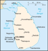
Sri Lanka, officially the Democratic Socialist Republic of Sri Lanka is a country off the southern coast of the Indian subcontinent. Known until 1972 as Ceylon , Sri Lanka is an island surrounded by the Indian Ocean, the Gulf of Mannar and the Palk Strait, and lies in the vicinity of India and the...
, also sometimes called Ceylon, is an island nation in the Indian Ocean
Indian Ocean
The Indian Ocean is the third largest of the world's oceanic divisions, covering approximately 20% of the water on the Earth's surface. It is bounded on the north by the Indian Subcontinent and Arabian Peninsula ; on the west by eastern Africa; on the east by Indochina, the Sunda Islands, and...
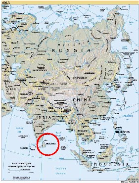
, located in Southern Asia, southeast of India
India
India , officially the Republic of India , is a country in South Asia. It is the seventh-largest country by geographical area, the second-most populous country with over 1.2 billion people, and the most populous democracy in the world...
, in a strategic location near major Indian Ocean sea lanes. It has a total area of 65,610 km², with 64,740 km² of land and 870 km² of water. Its coastline is 1,340 km long. Sri Lanka's climate includes tropical monsoons: the northeast monsoon (December to March), and the southwest monsoon (June to October). Its terrain is mostly low, flat to rolling plain, with mountains in the south-central interior. The highest point is Pidurutalagala
Pidurutalagala
Pidurutalagala , or Mount Pedro in English, is an ultra prominent peak, and the tallest mountain in Sri Lanka, at . Mount Pedro is located close to the city of Nuwara Eliya, and is easily visible from most areas of the Central Province....
at 2,524.13 m. Natural resources
Natural Resources
Natural Resources is a soul album released by Motown girl group Martha Reeves and the Vandellas in 1970 on the Gordy label. The album is significant for the Vietnam War ballad "I Should Be Proud" and the slow jam, "Love Guess Who"...
include limestone
Limestone
Limestone is a sedimentary rock composed largely of the minerals calcite and aragonite, which are different crystal forms of calcium carbonate . Many limestones are composed from skeletal fragments of marine organisms such as coral or foraminifera....
, graphite
Graphite
The mineral graphite is one of the allotropes of carbon. It was named by Abraham Gottlob Werner in 1789 from the Ancient Greek γράφω , "to draw/write", for its use in pencils, where it is commonly called lead . Unlike diamond , graphite is an electrical conductor, a semimetal...
, mineral sands, gems
Gems of Sri Lanka
Sri Lanka’s gem industry has a very long and colorful history. Sri Lanka was affectionately known as Ratna-Dweepa which means Gem Island. The name is a reflection of its natural wealth. Marco Polo wrote that the island had the best sapphires, topazes, amethysts, and other gems in the world...
, phosphates, clay, hydropower
Hydropower
Hydropower, hydraulic power, hydrokinetic power or water power is power that is derived from the force or energy of falling water, which may be harnessed for useful purposes. Since ancient times, hydropower has been used for irrigation and the operation of various mechanical devices, such as...
.
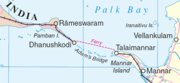
Rama's Bridge
Rama's Bridge
Adam's Bridge , also known as Rama's Bridge or Rama Setu , is a chain of limestone shoals, between Pamban Island, also known as Rameswaram Island, off the southeastern coast of Tamil Nadu, India, and Mannar Island, off the northwestern coast of Sri Lanka...
, a land connection to the Indian mainland that according to Hindu mythology
Hindu mythology
Hindu religious literature is the large body of traditional narratives related to Hinduism, notably as contained in Sanskrit literature, such as the Sanskrit epics and the Puranas. As such, it is a subset of Nepali and Indian culture...
was constructed during the rule of Rama
Rama
Rama or full name Ramachandra is considered to be the seventh avatar of Vishnu in Hinduism, and a king of Ayodhya in ancient Indian...
, is now mostly submerged with only a chain of limestone
Limestone
Limestone is a sedimentary rock composed largely of the minerals calcite and aragonite, which are different crystal forms of calcium carbonate . Many limestones are composed from skeletal fragments of marine organisms such as coral or foraminifera....
shoals remaining above sea level. According to temple records this natural causeway
Causeway
In modern usage, a causeway is a road or railway elevated, usually across a broad body of water or wetland.- Etymology :When first used, the word appeared in a form such as “causey way” making clear its derivation from the earlier form “causey”. This word seems to have come from the same source by...
was formerly complete, but was breached by a violent storm (probably a cyclone
Cyclone
In meteorology, a cyclone is an area of closed, circular fluid motion rotating in the same direction as the Earth. This is usually characterized by inward spiraling winds that rotate anticlockwise in the Northern Hemisphere and clockwise in the Southern Hemisphere of the Earth. Most large-scale...
) in 1480.
Geology
More than 85% of Sri Lanka's surface lies on PrecambrianPrecambrian
The Precambrian is the name which describes the large span of time in Earth's history before the current Phanerozoic Eon, and is a Supereon divided into several eons of the geologic time scale...
strata
Stratum
In geology and related fields, a stratum is a layer of sedimentary rock or soil with internally consistent characteristics that distinguish it from other layers...
, some of it dating back 2 billion years. The granulite facies rocks of the Highland Series (gneisses, sillimanite-graphite gneisses, quartzite, marbles, and some charnokites) make up most of the island and the amphibolite facies gneisses, granites, and granitic gneisses of the Vinjayan Series occur in the eastern and southeastern lowlands. Jurassic sediments are present in very small areas near the western coast and Miocene limestones underlie the northwestern part of the country and extend south in a relatively narrow belt along the west coast.The metamorphic rock
Metamorphic rock
Metamorphic rock is the transformation of an existing rock type, the protolith, in a process called metamorphism, which means "change in form". The protolith is subjected to heat and pressure causing profound physical and/or chemical change...
surface was created by the transformation of ancient sediments under intense heat and pressure during mountain-building processes. The theory of plate tectonics
Plate tectonics
Plate tectonics is a scientific theory that describes the large scale motions of Earth's lithosphere...
suggests that these rocks and related rocks forming most of south India were part of a single southern landmass called Gondwanaland. Beginning about 200 million years ago, forces within the Earth's mantle began to separate the lands of the Southern Hemisphere, and a crustal plate supporting both India and Sri Lanka moved toward the northeast. About 45 million years ago, the Indian plate collided with the Asian landmass, raising the Himalayas
Himalayas
The Himalaya Range or Himalaya Mountains Sanskrit: Devanagari: हिमालय, literally "abode of snow"), usually called the Himalayas or Himalaya for short, is a mountain range in Asia, separating the Indian subcontinent from the Tibetan Plateau...
in northern India, and continuing to advance slowly to the present time. Sri Lanka does not experience earthquakes or major volcanic events because it rides on the center of the plate.
The island contains relatively limited strata of sedimentation surrounding its ancient uplands. Aside from recent deposits along river valleys, only two small fragments of Jurassic (140 to 190 million years ago) sediment occur in Puttalam District, while a more extensive belt of Miocene
Miocene
The Miocene is a geological epoch of the Neogene Period and extends from about . The Miocene was named by Sir Charles Lyell. Its name comes from the Greek words and and means "less recent" because it has 18% fewer modern sea invertebrates than the Pliocene. The Miocene follows the Oligocene...
(5 to 100 million years ago) limestone is found along the northwest coast, overlain in many areas by Pleistocene
Pleistocene
The Pleistocene is the epoch from 2,588,000 to 11,700 years BP that spans the world's recent period of repeated glaciations. The name pleistocene is derived from the Greek and ....
(1 million years ago) deposits. The northwest coast is part of the deep Cauvery (Kaveri) River Basin of southeast India, which has been collecting sediments from the highlands of India and Sri Lanka since the breakup of Gondwanaland.
Topography

The south-central part of Sri Lanka—the rugged Central Highlands—is the heart of the country. The core of this area is a high plateau, running north-south for approximately 65 kilometers. This area includes Sri Lanka's highest mountains. (Pidurutalagala
Pidurutalagala
Pidurutalagala , or Mount Pedro in English, is an ultra prominent peak, and the tallest mountain in Sri Lanka, at . Mount Pedro is located close to the city of Nuwara Eliya, and is easily visible from most areas of the Central Province....
is the highest at 2,524 m) At the plateau's southern end, mountain ranges stretch 50 kilometers to the west toward Adam's Peak
Adam's Peak
Sri Pada , is a tall conical mountain located in central Sri Lanka...
(2,243 meters) and 50 kilometers to the east toward Namunakula (2,036 m). Flanking the high central ridges are two lower plateaus. On the west is the Hatton Plateau, a deeply dissected series of ridges sloping downward toward the north. On the east, the Uva
Uva Province
Uva is Sri Lanka's second least populated province, with 1,187,335 people, created in 1896. It consists of two districts: Badulla බදුල්ල பதுளை and Moneragala මොනරාගල மொனராகல. The provincial capital is Badulla. Uva is bordered by Eastern, Southern and Central provinces...
Basin consists of rolling hills covered with grasses, traversed by some deep valleys and gorges. To the north, separated from the main body of mountains and plateaus by broad valleys, lies the Knuckles Massif: steep escarpments, deep gorges, and peaks rising to more than 1,800 meters. South of Adam's Peak lie the parallel ridges of the Rakwana Hills, with several peaks over 1,400 meters. The land descends from the Central Highlands to a series of escarpments and ledges at 400 to 500 meters above sea level before sloping down toward the coastal plains.
Most of the island's surface consists of plains between 30 and 200 meters above sea level. In the southwest, ridges and valleys rise gradually to merge with the Central Highlands, giving a dissected appearance to the plain. Extensive erosion in this area has worn down the ridges and deposited rich soil for agriculture downstream. In the southeast, a red, lateritic soil covers relatively level ground that is studded with bare, monolithic hills. The transition from the plain to the Central Highlands is abrupt in the southeast, and the mountains appear to rise up like a wall. In the east and the north, the plain is flat, dissected by long, narrow ridges of granite running from the Central Highlands.
Climate
Sri Lanka's climate can be described as tropical, and quite hot. Its position between 5 and 10 north latitude endows the country with year-round warm weather, moderated by ocean winds and considerable moisture. The mean temperature ranges from a low of 16 °C (60.8 °F) in Nuwara EliyaNuwara Eliya
Nuwara Eliya , meaning "city on the plain " or "city of light", is a town in the central highlands of Sri Lanka with a picturesque landscape and temperate climate. It is located at an altitude of 1,868 m and is considered to be the most important location for Tea production in Sri Lanka...
in the Central Highlands (where frost may occur for several days in the winter) to a high of 32 °C (89.6 °F) in Trincomalee
Trincomalee
Trincomalee is a port city in Eastern Province, Sri Lanka and lies on the east coast of the island, about 113 miles south of Jaffna. It has a population of approximately 100,000 . The city is built on a peninsula, which divides the inner and outer harbours. Overlooking the Kottiyar Bay,...
on the northeast coast (where temperatures may reach 38 °C (100.4 °F)). The average yearly temperature for the country as a whole ranges from 28 to 30 °C (82.4 to 86 °F). Day and night temperatures may vary by 4 C-change to 7 C-change. January is the coolest month, especially in the highlands, where overnight temperatures may fall to 5 °C (41 °F). May, the hottest period, precedes the summer monsoon rains.
The rainfall pattern is influenced by the monsoon winds of the Indian Ocean
Indian Ocean
The Indian Ocean is the third largest of the world's oceanic divisions, covering approximately 20% of the water on the Earth's surface. It is bounded on the north by the Indian Subcontinent and Arabian Peninsula ; on the west by eastern Africa; on the east by Indochina, the Sunda Islands, and...
and Bay of Bengal
Bay of Bengal
The Bay of Bengal , the largest bay in the world, forms the northeastern part of the Indian Ocean. It resembles a triangle in shape, and is bordered mostly by the Eastern Coast of India, southern coast of Bangladesh and Sri Lanka to the west and Burma and the Andaman and Nicobar Islands to the...
and is marked by four seasons. The first is from mid-May to October, when winds originate in the southwest, bringing moisture from the Indian Ocean. When these winds encounter the slopes of the Central Highlands, they unload heavy rains on the mountain slopes and the southwestern sector of the island. Some of the windward slopes receive up to 2500 mm (98.4 in) of rain per month, but the leeward slopes in the east and northeast receive little rain. The second season occurs in October and November, the intermonsoonal months. During this season, periodic squalls occur and sometimes tropical cyclones bring overcast skies and rains to the southwest, northeast, and eastern parts of the island. During the third season, December to March, monsoon winds come from the northeast, bringing moisture from the Bay of Bengal. The northeastern slopes of the mountains may be inundated with up to 1250 mm (49.2 in) of rain during these months. Another intermonsoonal period occurs from March until mid-May, with light, variable winds and evening thundershowers.
Humidity is typically higher in the southwest and mountainous areas and depends on the seasonal patterns of rainfall. At Colombo
Colombo
Colombo is the largest city of Sri Lanka. It is located on the west coast of the island and adjacent to Sri Jayawardenapura Kotte, the capital of Sri Lanka. Colombo is often referred to as the capital of the country, since Sri Jayawardenapura Kotte is a satellite city of Colombo...
, for example, daytime humidity stays above 70% all year, rising to almost 90 percent during the monsoon season in June. Anuradhapura
Anuradhapura
Anuradhapura, , is one of the ancient capitals of Sri Lanka, famous for its well-preserved ruins of ancient Lankan civilization.The city, now a UNESCO World Heritage Site, lies 205 km north of the current capital Colombo in Sri Lanka's North Central Province, on the banks of the historic...
experiences a daytime low of 60% during the intermonsoonal month of March, but a high of 79% during the November and December rains. In the highlands, Kandy's daytime humidity usually ranges between 70 and 79%.
Ecological zones
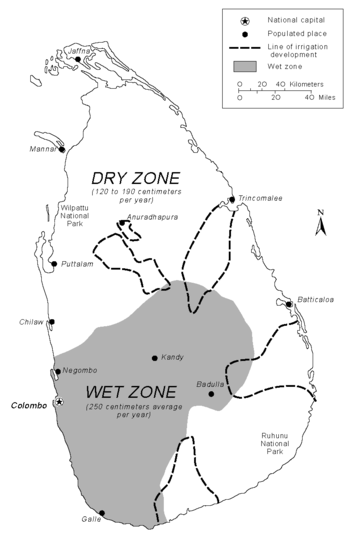
The natural vegetatian of the dry zone is adapted to the annual change from flood to drought. The typical ground cover is scrub forest, interspersed with tough bushes and cactuses in the driest areas. Plants grow very fast from November to February when rainfall is heavy, but stop growing during the hot season from March to August. Various adaptations to the dry conditions have developed. To conserve water, trees have thick bark; most have tiny leaves, and some drop their leaves during this season. Also, the topmost branches of the tallest trees often interlace, forming a canopy against the hot sun and a barrier to the dry wind. When water is absent, the plains of the dry zone are dominated by browns and grays. When water becomes available, either during the wet season or through proximity to rivers and lakes, the vegetation explodes into shades of green with a wide variety of beautiful flowers. Varieties of flowering acacias are well adapted to the arid conditions and flourish on the Jaffna
Jaffna
Jaffna is the capital city of the Northern Province, Sri Lanka. It is the administrative headquarters of the Jaffna district located on a peninsula of the same name. Jaffna is approximately six miles away from Kandarodai which served as a famous emporium in the Jaffna peninsula from classical...
Peninsula. Among the trees of the dry-land forests are some valuable species, such as satinwood
Satinwood
Satinwood can mean the following:*A name for a wood that can be polished to a high gloss derived from certain species of the flowering plant family Rutaceae:**Chloroxylon swietenia, Ceylon satinwood or East Indian satinwood...
, ebony
Ebony
Ebony is a dense black wood, most commonly yielded by several species in the genus Diospyros, but ebony may also refer to other heavy, black woods from unrelated species. Ebony is dense enough to sink in water. Its fine texture, and very smooth finish when polished, make it valuable as an...
, ironwood
Ironwood
Ironwood is a common name for a large number of woods that have a reputation for hardness. Usage of the name may include the tree that yields this wood...
, and mahogany
Mahogany
The name mahogany is used when referring to numerous varieties of dark-colored hardwood. It is a native American word originally used for the wood of the species Swietenia mahagoni, known as West Indian or Cuban mahogany....
.
In the wet zone, the dominant vegetation of the lowlands is a tropical evergreen forest, with tall trees, broad foliage, and a dense undergrowth of vines and creepers. Subtropical evergreen forests resembling those of temperate climates flourish in the higher altitudes. Mountain vegetation at the highest altitudes tends to be stunted and windswept.
Forests at one time covered nearly the entire island, but by the late 20th century lands classified as forests and forest reserves covered only one-fifth of the land. The southwestern interior contains the only large remnants of the original forests of the wet zone. The government has attempted to preserve sanctuaries for natural vegetation and animal life, however. Ruhunu National Park
Yala National Park
Yala National Park is the most visited and second largest national park in Sri Lanka. Actually it consists of five blocks, two of which are now open to the public; and also adjoining parks. The blocks have individual names also, like Ruhuna National Park for the block 1 and Kumana National Park or...
in the southeast protects herds of elephant, deer, and peacocks, and Wilpattu National Park
Wilpattu National Park
Wilpattu National Park is a park located on the island of Sri Lanka. The unique feature of this park is the existence of "Willus" - Natural, sand-rimmed water basins or depressions that fill with rainwater. Located in the Northwest coast lowland dry zone of Sri Lanka...
in the northwest preserves the habitats of many water birds, such as storks, pelicans, ibis, and spoonbills. During the Mahaweli Ganga
Mahaweli Ganga
The Mahaweli River , is a long river, ranking as the longest river in Sri Lanka. Its drainage basin is the largest in the country, and covers almost one-fifth of the total area of the island. The river reaches the Bay of Bengal on the southwestern side of Trincomalee Bay...
Program of the 1970s and 1980s in northern Sri Lanka, the government set aside four areas of land totalling 1,900 km² as national parks.
Land use and settlement patterns
The dominant pattern of human settlement during the last 3,000 years has consisted of village farming communities. Even in the 1970s, the majority of people lived in small villages and worked at agricultural pursuits. Traditional farming techniques and life-styles revolve around two types of farming--"wet" and "dry"--depending upon the availability of water.The typical settlement pattern in the rice-growing areas is a compact group of houses or neighborhood surrounding one or several religious centers that serve as the focus for communal activities. Sometimes the houses may be situated along a major road and include a few shops, or the village may include several outlying hamlets. The life-sustaining rice fields begin where the houses (hi friends it is nick here end and stretch into the distance. Some irrigated fields may include other cash crops, such as sugarcane, or groves of coconut trees. Palmyra trees grow on the borders of fields or along roads and paths. Individual houses also may have vegetable gardens in their compounds. During the rainy seasons and thereafter, when the fields are covered by growing crops, the village environment is intensely verdant.
The nature of agricultural pursuits in Sri Lanka has changed over the centuries and has usually depended upon the availability of arable land and water resources. In earlier times, when villagers had access to plentiful forests that separated settlements from each other, slash-and-burn agriculture was a standard technique. As expanding population and commercial pressures reduced the amount of available forestland, however, slash-and-burn cultivation steadily declined in favor of permanent cultivation by private owners. Until the 13th century, the village farming communities were mainly on the northern plains around Anuradhapura
Anuradhapura
Anuradhapura, , is one of the ancient capitals of Sri Lanka, famous for its well-preserved ruins of ancient Lankan civilization.The city, now a UNESCO World Heritage Site, lies 205 km north of the current capital Colombo in Sri Lanka's North Central Province, on the banks of the historic...
and then Polonnaruwa
Polonnaruwa
The second most ancient of Sri Lanka's kingdoms, was first declared the capital city by King Vijayabahu I, who defeated the Chola invaders in 1070 AD to reunite the country once more under a local leader.-History:While Vijayabahu's victory and shifting of Kingdoms to the more strategic Polonnaruwa...
, but they later shifted to the southwest. In the 1970s, wide expanses of the northern and eastern plains were sparsely populated, with scattered villages each huddled around an artificial lake. The Jaffna
Jaffna
Jaffna is the capital city of the Northern Province, Sri Lanka. It is the administrative headquarters of the Jaffna district located on a peninsula of the same name. Jaffna is approximately six miles away from Kandarodai which served as a famous emporium in the Jaffna peninsula from classical...
Peninsula, although a dry area, is densely populated and intensively cultivated. The southwest contains most of the people, and villages are densely clustered with little unused land. In the Central Highlands around Kandy
Kandy
Kandy is a city in the center of Sri Lanka. It was the last capital of the ancient kings' era of Sri Lanka. The city lies in the midst of hills in the Kandy plateau, which crosses an area of tropical plantations, mainly tea. Kandy is one of the most scenic cities in Sri Lanka; it is both an...
, villagers faced with limited flat land have developed intricately terraced hillsides where they grow rice. In the 1960s and 1970s, the wet cultivation area was expanding rapidly, as the government implemented large-scale irrigation projects to restore the dry zone to agricultural productivity. In the 1970s, the area drained by the Mahaweli Ganga
Mahaweli Ganga
The Mahaweli River , is a long river, ranking as the longest river in Sri Lanka. Its drainage basin is the largest in the country, and covers almost one-fifth of the total area of the island. The river reaches the Bay of Bengal on the southwestern side of Trincomalee Bay...
changed from a sparsely inhabited region to a wet rice area similar to the southwest. Through such projects, the government of Sri Lanka has planned to recreate in the dry zone the lush, irrigated landscape associated with the ancient Sinhalese civilization.
Beginning in the 16th century and culminating during the British
British Empire
The British Empire comprised the dominions, colonies, protectorates, mandates and other territories ruled or administered by the United Kingdom. It originated with the overseas colonies and trading posts established by England in the late 16th and early 17th centuries. At its height, it was the...
rule of the 19th and twentieth centuries, the plantation economy came to dominate large sections of the highlands. Plantation farming resulted in a drastic reduction in the natural forest cover and the substitution of domesticated crops, such as rubber
Rubber
Natural rubber, also called India rubber or caoutchouc, is an elastomer that was originally derived from latex, a milky colloid produced by some plants. The plants would be ‘tapped’, that is, an incision made into the bark of the tree and the sticky, milk colored latex sap collected and refined...
, tea
Tea
Tea is an aromatic beverage prepared by adding cured leaves of the Camellia sinensis plant to hot water. The term also refers to the plant itself. After water, tea is the most widely consumed beverage in the world...
, or cinnamon
Cinnamon
Cinnamon is a spice obtained from the inner bark of several trees from the genus Cinnamomum that is used in both sweet and savoury foods...
. It also brought about a changed life-style, as the last hunting-and-gathering societies retreated into smaller areas and laborers moved into the highlands to work on plantations. Through the late twentieth century, workers on large plantations lived in villages of small houses or in "line rooms" containing ten to twelve units. The numerous plantations of small landholders frequently included attached hamlets of workers in addition to the independent houses of the plantation owners.
The coastal belt surrounding the island contains a different settlement pattern that has evolved from older fishing villages. Separate fishing settlements expanded laterally along the coast, linked by a coastal highway and a railway. The mobility of the coastal population during colonial times and after independence led to an increase in the size and number of villages, as well as to the development of growing urban centers with outside contacts. In the 1980s, it was possible to drive for many kilometers along the southwest coast without finding a break in the string of villages and bazaar centers merging into each other and into towns.
Land use:
arable land:
14%
permanent crops:
15%
permanent pastures:
7%
forests and woodland:
32%
other:
32% (1993 est.)
Irrigated land:
5,500 km² (1993 est.)
Maritime claims
contiguous zone:
24 nmi (44.4 km)
continental shelf:
200 nmi (370.4 km) or to the edge of the continental margin
exclusive economic zone:
200 nmi (370.4 km)
territorial sea:
12 nmi (22.2 km)
See also
- Environment of Sri Lanka
- Islands of Sri Lanka
- List of rivers in Sri Lanka
- List of waterfalls in Sri Lanka
- 2000 Sri Lanka cyclone2000 Sri Lanka cycloneThe 2000 Sri Lanka Cyclone, , was the strongest tropical cyclone to strike Sri Lanka since 1978. The fourth tropical storm and the second severe cyclonic storm of the 2000 North Indian Ocean cyclone season, it developed from an area of disturbed weather on December 25, 2000...