

Geography of Southern California
Encyclopedia
The geography of Southern California is greatly influenced by Transverse Ranges
Transverse Ranges
The Transverse Ranges are a group of mountain ranges of southern California, in the Pacific Coast Ranges physiographic region that runs along the Pacific coast from Alaska to Mexico in North America. The Transverse Ranges begin at the southern end of the California Coast Ranges and lie between...
and the Peninsular Ranges
Peninsular Ranges
The Peninsular Ranges are a group of mountain ranges, in the Pacific Coast Ranges, which stretch from southern California in the United States to the southern tip of Mexico's Baja California peninsula; they are part of the North American Coast Ranges that run along the Pacific coast from Alaska...
; magnificent physical landscapes that have shaped Southern California
Southern California
Southern California is a megaregion, or megapolitan area, in the southern area of the U.S. state of California. Large urban areas include Greater Los Angeles and Greater San Diego. The urban area stretches along the coast from Ventura through the Southland and Inland Empire to San Diego...
and affected its development. Both ranges have their particular characteristics, from the trend of the mountains, to the different climates within in each range. Climate can be examined in each of the ranges through the physical locations of the ranges. These two mountain ranges are a perfect example of the differences in climate found within California.
Climate
There is a common belief that California is a place of sunshine and perfect weather conditions but this is not the case. Although some parts of California do live up to this notion, some areas in California have extreme climatic conditions. Around the coastal areas, the weather does not vary drastically like it does in the Inland areas. Climate is affected by factors such as latitude, topography, and the proximity to water masses. The Transverse ranges and the peninsular ranges are perfect examples that demonstrate the different temperature and climatic differences within California. California crosses ten latitude degrees but these all fall under the multitude temperature zone and this is why overall there is not much variation in temperature.June Gloom
The sun-seeking know to avoid southern California beaches in the late spring, This period known to the locals as June GloomJune Gloom
June Gloom is a southern California term for a weather pattern that results in cloudy, overcast skies with cool temperatures during the late spring and early summer. June Gloom in southern California is caused by the marine layer effect common to the West Coast, and is enhanced by the Catalina eddy...
often darkens the coastal skies of sunny southern California. During this time, the coastal clouds may remain all day, but often give way to some hazy afternoon sunshine. The number of days during this month period that are gloomy vary from year to year. The years with warmer ocean temperatures, referred to as El Niño, may result in fewer gray days in June. Cooler ocean temperatures, associated with La Niña, usually foretell a more gray season.
Fog
The Southern California Fog is the collection of water droplets or ice crystals suspended in the air at or near the Earth's surface. While fog is a type of a cloud, the term fog is typically distinguished from the more generic term cloud in that fog is low-lying, and the moisture in the fog is often generated locally .as an example is the fog of san Francisco it has a specific case of sea fog. Sea fog is a specific type of advection fog, which is characterized by the lateral transfer of temperature by wind blowing over cooler water the it is created when warm, moist air blows from the central Pacific Ocean across the cold water of the California Current, which flows just off the coast. This creates cool moist wind along the coast, and this is a picture that show an example of Southern California Fog.Low Clouds
The Low Clouds in Southern California is a visible mass of droplets of water or frozen crystals suspended in the atmosphere above the surface of the Earth or other planetary body. Clouds in the Earth's atmosphere are studied in the nephrology or cloud physics branch of meteorology. it has to do with high pressure. During the spring and early summer the east Pacific anticyclone high pressure area strengthens and moves northward and the Aleutian Low attenuates, High Pressure is associated with weaker winds and sinking air and this is a picture that shows a slow clouds in southern California, and this is a picture that’s shows an example of the Low Clouds in Southern California.Transverse Ranges
The Transverse Ranges is a very unique set of mountain ranges in California. They are the only mountain ranges that run west to east opposed to the rest of California’s ranges that run north to south. The reason for this direction is that “during the history of the San Andreas Fault, the Transverse Ranges broke off from the North American Plate. With its northern end still attached to the North American Plate and its Southern end dragged by the Pacific Plate moving northward, it turned clockwise and formed the west-east mountains"(Hyslop, Wu, and Garver). These mountain ranges roughly run from Santa Barbra County to San Bernardino County.Climate
The Transverse ranges experiences a temperature difference from winter to summer of about 20 degrees Celsius. One of the factors that contribute to this notable difference is the distance from the ocean. The physical properties of water are the reason why there is little variation in temperature along the coastal areas. The further the ranges are from a body of water, the greater the variation in temperature will be. The Eastern part of the transverse ranges is furthest away from the coastal area and has the most drastic temperature variation within the range. The west part of the Transverse ranges is closets to the ocean and therefore has less variance in their climate. During the warm summer, the oceans provide humidity in the form of fog. The amount of precipitation an area has is affected by the elevation of the place. Topography can be explained as the influence on temperature with elevation. The higher the elevation is, the lower the temperatures are. With lower temperatures, precipitation increases. The transverse range highest point is Mt. San Gorgonio. In these ranges evaporation is extreme and is the reason why plants that need a great deal of moisture cannot survive here. The southeastern part of the transverse ranges can be considered to have a Desert climate. Mountain ranges can cause a rain shadow effect, when air flow inland from the ocean and it rises, it begins to cool and after it reaches the other side of the mountain it becomes warm and evaporates. This is one of the reasons for the dry conditions in the Transverse ranges that are furthest from the coast. The transverse ranges are affected by the Santa Ana winds. The Santa Ana winds are a regional wind system that is created when air is forced from a high pressure to a low pressure, causing air to move from inland into the ocean. These winds usually originate in the eastern side of the Transverse range.Geology
The San Andreas Fault and many other faults run through the Transverse Ranges. Because of this, this area is one of the most geologically active regions in the state of California. This area is known for being one of the most uplifting areas in the world. Uplifting meaning when an earthquake occur these ranges can rise anywhere from 28 inches to 6 feet. This can cause a major shift to the geography of the area. Sedimentary rocks from the late Mesozoic and early Cenozoic eras are found in the western part of the region. Near the eastern ranges, such as the San Bernardino Mountains, metamorphic rocks that resemble rocks of Sierra Nevada can be found.Ranges
These east to west running ranges include a variety of different mountains. Some mountains are steep like the San Gabriel Mountains. Other areas of the Transverse Ranges have a very low elevation like the Mojave Desert. The mountains of the Transverse ranges include:- Santa Ynez MountainsSanta Ynez MountainsThe Santa Ynez Mountains are a portion of the Transverse Ranges, part of the Pacific Coast Ranges of the west coast of North America, and are one of the northernmost mountain ranges in Southern California.-Geography:...
- San Rafael MountainsSan Rafael MountainsThe San Rafael Mountains are a mountain range in central Santa Barbara County, California, U.S.. They are part of the Transverse Ranges system of Southern California which in turn are part of the Pacific Coast Ranges system of western North America....
- Sierra Madre Mountains
- Topatopa MountainsTopatopa MountainsThe Topatopa Mountains are a mountain range in Ventura County, California, north of Santa Paula. They are part of the Transverse Ranges of Southern California. The range lies in an east-west direction northeast of the community of Ojai, and west of the Sespe Condor Sanctuary. The ranges reaches an...
- Santa Susana MountainsSanta Susana MountainsThe Santa Susana Mountains are a transverse range of mountains in southern California, north of the city of Los Angeles, in the United States. The range runs east-west separating the San Fernando Valley and Simi Valley on its south, from Santa Clara River Valley to the north, and Santa Clarita...
- Simi HillsSimi HillsThe Simi Hills are a low rocky mountain range of the Transverse Ranges, located in eastern Ventura County and western Los Angeles County, of southern California, United States.-Geography:...
- Chalk HillsChalk HillsThe Chalk Hills are a north—south running low 'mountain' range in the San Fernando Valley perpendicular to and adjoining the Santa Monica Mountains. They are located in the Woodland Hills District of the City of Los Angeles in Southern California.-Environs:...
- Santa Monica MountainsSanta Monica MountainsThe Santa Monica Mountains are a Transverse Range in Southern California, along the coast of the Pacific Ocean in the United States.-Geography:...
- San Gabriel MountainsSan Gabriel MountainsThe San Gabriel Mountains Range is located in northern Los Angeles County and western San Bernardino County, California, United States. The mountain range lies between the Los Angeles Basin and the Mojave Desert, with Interstate 5 to the west and Interstate 15 to the east...
- San Rafael HillsSan Rafael HillsThe San Rafael Hills are a mountain range in Los Angeles County, California. They are one of the lower Transverse Ranges, and are parallel to and below the San Gabriel Mountains to the south, adjacent to the San Gabriel Valley overlooking the Los Angeles Basin.-Geography:The Hills contain all or...
- Puente HillsPuente HillsThe Puente Hills is a chain of hills, one of the lower Transverse Ranges, in an unincorporated area in eastern Los Angeles County, California.-Geography:...
- San Jose HillsSan Jose HillsThe San Jose Hills are a part of the Transverse Ranges located in Eastern Los Angeles County, California, marking the border between the San Gabriel Valley and the Pomona Valley in the Inland Empire. It includes portions of Covina, West Covina, Walnut, Pomona, and San Dimas.- Geology :The San Jose...
- San Bernardino MountainsSan Bernardino MountainsThe San Bernardino Mountains are a short transverse mountain range north and east of San Bernardino in Southern California in the United States. The mountains run for approximately 60 miles east-west on the southern edge of the Mojave Desert in southwestern San Bernardino County, north of the...
- Little San Bernardino MountainsLittle San Bernardino MountainsThe Little San Bernardino Mountains are a short mountain range of the Transverse Ranges, located in southern California in the United States. They extend for approximately 40 mi southeast from the San Bernardino Mountains through San Bernardino and Riverside Counties to near the northeast...
- Tehachapi MountainsTehachapi MountainsThe Tehachapi Mountains , regionally also called The Tehachapis, are a mountain range in the Transverse Ranges system of California in the Western United States...
- Sierra Pelona MountainsSierra Pelona MountainsThe Sierra Pelona Mountains , or the Sierra Pelona Ridge, is a mountain range in the Transverse Ranges of Southern California.. They are located within Los Angeles and Kern Counties.-Geography:...
- San Emigdio MountainsSan Emigdio MountainsThe San Emigdio Mountains are a part of the Transverse Ranges in Southern California, extending from Interstate 5 at Lebec and Gorman on the east to Highway 33–166 on the west. They link the Tehachapis and Temblor Range and form the southern wall of the San Joaquin Valley.The range is within Los...
Urban Interaction
People have taken full advantage of the Transverse Ranges. This range creates a number of coastal plans and valleys. These areas have become highly populated because of their prime living conditions. Some of these valleys include: Oxnard Plain, San Fernando Valley, Simi Valley, San Gabriel Valley, and the Inland Valley. These receive a large amount of run-off water that comes down from the mountains that surround them. The valleys in this area are known to have a lot of green areas of high vegetation. Not only the valleys are put to use, but also the mountain ranges create recreation and living areas. The San Gabriel Mountains are a great location for Southern Californian looking for a close snow getaway. These mountains are home to a couple of ski resorts and provide unless hiking and off-roading to the adventurous types. Many people find homes in the hills of the Transverse Ranges. They provide a place to get away from all the city noise of Southern California.Peninsular Ranges
These ranges were formed about 140 to 150 million years ago. They were formed by the North American Plate and the Pacific Plate gradually moving together and eventually colliding. The molten rock and magma pushed upward which then formed these peninsular ranges. The rocks in the ranges are mostly composed of Mesozoic Granitic rocks. The plants and vegetation in these ranges consist of coastal sage scrub to chaparral, and from oak woodland to conifer forest.
The Peninsular ranges of Southern California include: the Santa Ana Mountains, San Jacinto Mountains, and the Laguna Mountains. The Peninsular ranges of Baja California include: the Sierra Juarez, Sierra San Pedro Martir, Sierra de la Giganta, and Sierra de la Laguna. These ranges run from north to south.
The Santa Ana mountains are the largest natural landscape along the coast of Southern California. These mountains peak at about 5,689 feet. This range starts in the north, starting in the Chino Hills area heading southeast to the Puente Hills region.
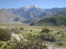
The San Jacinto Mountains are located in the desert areas in the north and east side of Southern California. The San Jacinto Mountains peaks at about 10,833 feet. These mountain ranges are located on the eastern part of Southern California. They run from the San Bernardino Mountains southeast to the San Rosa Mountains. This mountain range is the northernmost part of the Peninsular Range.
The Laguna Mountains are located in the eastern part of San Diego County. These mountains peak at about 6,378 feet. These mountains run northwest to southeast for approximately 20 miles. These mountains are about 35 miles away from the Sierra Juarez mountain range.
The Sierra Juarez and the San Pedro Martir both experience the most extreme Mediterranean climate out of all the ranges. Theses mountains peak at about 10,157 feet. The western part of this mountain experiences the Mediterranean climate and are also covered by chaparral.
The San Pedro Martir is very similar to the Sierra de Juarez in vegetation life. It is covered by charparral and desert shurb.
The Sierra de la Giganta are located in the southern part of the mountain ranges in the Baja California Peninsula. This mountain range is located on the northwestern part of Mexico. This range runs parallel to the Gulf Coast of California.
The Sierra de la Laguna mountain ranges is located in the Baja California Peninsula of Mexico. These mountains are at the southern end of the Peninsula Range. This mountain range consists of dry pine-oak forests in the lower regions of the mountain