
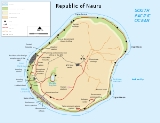
Geography of Nauru
Encyclopedia
Nauru
is a tiny phosphate rock island nation located in the South Pacific Ocean
south of the Marshall Islands
in Oceania
. It is only 53 kilometres (32.9 mi) south of the Equator
at coordinates
0°32′S 166°55′E. Nauru is one of the three great phosphate rock islands in the Pacific Ocean — the others are Banaba
(Ocean Island) in Kiribati
and Makatea
in French Polynesia
.
Its land area is 21 km² (8.1 sq mi), and it has a 30 kilometres (18.6 mi). Maritime claims are a 200-nautical-mile (370 km) exclusive fishing zone, and a 12-nautical-mile (22 km) territorial sea.
The climate
is tropical with a monsoon
ial rainy season from November to February.
A sandy beach rises to the fertile ring around raised coral reef
s. The raised phosphate plateau ('Topside') takes up the central portion of the island. The highest point is 200 ft (61 m) above sea level, along the plateau rim.
Nauru's only economically significant natural resources are phosphate
s, formed from guano
deposits by seabirds over many thousands of years, and fisheries, particularly for tuna
.
Due to being surrounded by coral
s and sandy beaches, the island houses no natural harbours, nor any river
s or substantial lake
s.
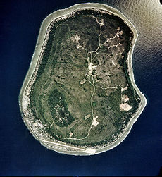 Nauru is a raised coral atoll
positioned in the Nauru Basin of the Pacific Ocean, on a part of the Pacific Plate
that formed at a mid oceanic ridge at 132 Ma.
From mid Eocene
(35mya) to Oligocene
times a submarine volcano
built up over a hotspot
, and formed a seamount
composed of basalt
. The seamount is over 4300 meters high. This hotspot was simultaneous with a major
Pacific Plate reorganisation. The volcano was eroded to sealevel and a coral
atoll
grew on top to a thickness of about 500 meters. Coral near the surface has been dated from 5 Mya to 0.3 Mya. The original limestone has been dolomitised by magnesium
from sea water. The coral was
raised above sea level about 30 meters, and is now a dolomite limestone outcrop which was eroded in classic karst
style into pinnacle
s up to 20 meters high. To at least a depth of 55 meters below sea level, the limestone has been dissolved forming cavities, sinkholes and caves. Holes on the topside of the island were filled up by a phosphate
layer up to several meters thick.
Anibare Bay
was formed by the underwater collapse of the east side of the volcano.
Buada Lagoon
was formed by solution of the limestone when the sea level was lower, followed by collapse.
Nauru is moving at 104 mm per year to the north west along with the Pacific Plate.
Freshwater can be found in Buada lagoon, and also in some brackish ponds at the escarpment base in Ijuw and Anabar in the northeast. There is an underground lake in Moqua Cave in the southeast of the island.
Nauru is party to the international environmental agreements on biodiversity
, climate change
, desertification
, law of the sea
and marine dumping.
, the points that are farther north, south, east or west than any other location.
Nauru
Nauru , officially the Republic of Nauru and formerly known as Pleasant Island, is an island country in Micronesia in the South Pacific. Its nearest neighbour is Banaba Island in Kiribati, to the east. Nauru is the world's smallest republic, covering just...
is a tiny phosphate rock island nation located in the South Pacific Ocean
Pacific Ocean
The Pacific Ocean is the largest of the Earth's oceanic divisions. It extends from the Arctic in the north to the Southern Ocean in the south, bounded by Asia and Australia in the west, and the Americas in the east.At 165.2 million square kilometres in area, this largest division of the World...
south of the Marshall Islands
Marshall Islands
The Republic of the Marshall Islands , , is a Micronesian nation of atolls and islands in the middle of the Pacific Ocean, just west of the International Date Line and just north of the Equator. As of July 2011 the population was 67,182...
in Oceania
Oceania
Oceania is a region centered on the islands of the tropical Pacific Ocean. Conceptions of what constitutes Oceania range from the coral atolls and volcanic islands of the South Pacific to the entire insular region between Asia and the Americas, including Australasia and the Malay Archipelago...
. It is only 53 kilometres (32.9 mi) south of the Equator
Equator
An equator is the intersection of a sphere's surface with the plane perpendicular to the sphere's axis of rotation and containing the sphere's center of mass....
at coordinates
Geographic coordinate system
A geographic coordinate system is a coordinate system that enables every location on the Earth to be specified by a set of numbers. The coordinates are often chosen such that one of the numbers represent vertical position, and two or three of the numbers represent horizontal position...
0°32′S 166°55′E. Nauru is one of the three great phosphate rock islands in the Pacific Ocean — the others are Banaba
Banaba Island
Banaba Island , an island in the Pacific Ocean, is a solitary raised coral island west of the Gilbert Island chain and 300 km east of Nauru. It is part of the Republic of Kiribati. It has an area of 6.5 km², and the highest point on the island is also the highest point in Kiribati, at 81...
(Ocean Island) in Kiribati
Kiribati
Kiribati , officially the Republic of Kiribati, is an island nation located in the central tropical Pacific Ocean. The permanent population exceeds just over 100,000 , and is composed of 32 atolls and one raised coral island, dispersed over 3.5 million square kilometres, straddling the...
and Makatea
Makatea
Makatea, or Mangaia-te-vai-tamae, is a raised coral atoll in the northwestern part of the Tuamotus. It is located 79 km southwest from Rangiroa to the west of the Palliser group. It is surrounded by spectacular cliffs, rising to a plateau 80 meters above the sea level. This island is...
in French Polynesia
French Polynesia
French Polynesia is an overseas country of the French Republic . It is made up of several groups of Polynesian islands, the most famous island being Tahiti in the Society Islands group, which is also the most populous island and the seat of the capital of the territory...
.
Its land area is 21 km² (8.1 sq mi), and it has a 30 kilometres (18.6 mi). Maritime claims are a 200-nautical-mile (370 km) exclusive fishing zone, and a 12-nautical-mile (22 km) territorial sea.
The climate
Climate
Climate encompasses the statistics of temperature, humidity, atmospheric pressure, wind, rainfall, atmospheric particle count and other meteorological elemental measurements in a given region over long periods...
is tropical with a monsoon
Monsoon
Monsoon is traditionally defined as a seasonal reversing wind accompanied by corresponding changes in precipitation, but is now used to describe seasonal changes in atmospheric circulation and precipitation associated with the asymmetric heating of land and sea...
ial rainy season from November to February.
A sandy beach rises to the fertile ring around raised coral reef
Coral reef
Coral reefs are underwater structures made from calcium carbonate secreted by corals. Coral reefs are colonies of tiny living animals found in marine waters that contain few nutrients. Most coral reefs are built from stony corals, which in turn consist of polyps that cluster in groups. The polyps...
s. The raised phosphate plateau ('Topside') takes up the central portion of the island. The highest point is 200 ft (61 m) above sea level, along the plateau rim.
Nauru's only economically significant natural resources are phosphate
Phosphate
A phosphate, an inorganic chemical, is a salt of phosphoric acid. In organic chemistry, a phosphate, or organophosphate, is an ester of phosphoric acid. Organic phosphates are important in biochemistry and biogeochemistry or ecology. Inorganic phosphates are mined to obtain phosphorus for use in...
s, formed from guano
Guano
Guano is the excrement of seabirds, cave dwelling bats, and seals. Guano manure is an effective fertilizer due to its high levels of phosphorus and nitrogen and also its lack of odor. It was an important source of nitrates for gunpowder...
deposits by seabirds over many thousands of years, and fisheries, particularly for tuna
Tuna
Tuna is a salt water fish from the family Scombridae, mostly in the genus Thunnus. Tuna are fast swimmers, and some species are capable of speeds of . Unlike most fish, which have white flesh, the muscle tissue of tuna ranges from pink to dark red. The red coloration derives from myoglobin, an...
.
Due to being surrounded by coral
Coral
Corals are marine animals in class Anthozoa of phylum Cnidaria typically living in compact colonies of many identical individual "polyps". The group includes the important reef builders that inhabit tropical oceans and secrete calcium carbonate to form a hard skeleton.A coral "head" is a colony of...
s and sandy beaches, the island houses no natural harbours, nor any river
River
A river is a natural watercourse, usually freshwater, flowing towards an ocean, a lake, a sea, or another river. In a few cases, a river simply flows into the ground or dries up completely before reaching another body of water. Small rivers may also be called by several other names, including...
s or substantial lake
Lake
A lake is a body of relatively still fresh or salt water of considerable size, localized in a basin, that is surrounded by land. Lakes are inland and not part of the ocean and therefore are distinct from lagoons, and are larger and deeper than ponds. Lakes can be contrasted with rivers or streams,...
s.
Geology of Nauru
Raised coral atoll
A raised coral atoll is a typical atoll which has been lifted high enough above sea level by tectonic forces to protect it from scouring by storms and enable soils and diverse – often endemic – species of flora and fauna to develop...
positioned in the Nauru Basin of the Pacific Ocean, on a part of the Pacific Plate
Pacific Plate
The Pacific Plate is an oceanic tectonic plate that lies beneath the Pacific Ocean. At 103 million square kilometres, it is the largest tectonic plate....
that formed at a mid oceanic ridge at 132 Ma.
From mid Eocene
Eocene
The Eocene Epoch, lasting from about 56 to 34 million years ago , is a major division of the geologic timescale and the second epoch of the Paleogene Period in the Cenozoic Era. The Eocene spans the time from the end of the Palaeocene Epoch to the beginning of the Oligocene Epoch. The start of the...
(35mya) to Oligocene
Oligocene
The Oligocene is a geologic epoch of the Paleogene Period and extends from about 34 million to 23 million years before the present . As with other older geologic periods, the rock beds that define the period are well identified but the exact dates of the start and end of the period are slightly...
times a submarine volcano
Volcano
2. Bedrock3. Conduit 4. Base5. Sill6. Dike7. Layers of ash emitted by the volcano8. Flank| 9. Layers of lava emitted by the volcano10. Throat11. Parasitic cone12. Lava flow13. Vent14. Crater15...
built up over a hotspot
Hotspot (geology)
The places known as hotspots or hot spots in geology are volcanic regions thought to be fed by underlying mantle that is anomalously hot compared with the mantle elsewhere. They may be on, near to, or far from tectonic plate boundaries. There are two hypotheses to explain them...
, and formed a seamount
Seamount
A seamount is a mountain rising from the ocean seafloor that does not reach to the water's surface , and thus is not an island. These are typically formed from extinct volcanoes, that rise abruptly and are usually found rising from a seafloor of depth. They are defined by oceanographers as...
composed of basalt
Basalt
Basalt is a common extrusive volcanic rock. It is usually grey to black and fine-grained due to rapid cooling of lava at the surface of a planet. It may be porphyritic containing larger crystals in a fine matrix, or vesicular, or frothy scoria. Unweathered basalt is black or grey...
. The seamount is over 4300 meters high. This hotspot was simultaneous with a major
Pacific Plate reorganisation. The volcano was eroded to sealevel and a coral
Coral
Corals are marine animals in class Anthozoa of phylum Cnidaria typically living in compact colonies of many identical individual "polyps". The group includes the important reef builders that inhabit tropical oceans and secrete calcium carbonate to form a hard skeleton.A coral "head" is a colony of...
atoll
Atoll
An atoll is a coral island that encircles a lagoon partially or completely.- Usage :The word atoll comes from the Dhivehi word atholhu OED...
grew on top to a thickness of about 500 meters. Coral near the surface has been dated from 5 Mya to 0.3 Mya. The original limestone has been dolomitised by magnesium
Magnesium
Magnesium is a chemical element with the symbol Mg, atomic number 12, and common oxidation number +2. It is an alkaline earth metal and the eighth most abundant element in the Earth's crust and ninth in the known universe as a whole...
from sea water. The coral was
raised above sea level about 30 meters, and is now a dolomite limestone outcrop which was eroded in classic karst
KARST
Kilometer-square Area Radio Synthesis Telescope is a Chinese telescope project to which FAST is a forerunner. KARST is a set of large spherical reflectors on karst landforms, which are bowlshaped limestone sinkholes named after the Kras region in Slovenia and Northern Italy. It will consist of...
style into pinnacle
Pinnacle
A pinnacle is an architectural ornament originally forming the cap or crown of a buttress or small turret, but afterwards used on parapets at the corners of towers and in many other situations. The pinnacle looks like a small spire...
s up to 20 meters high. To at least a depth of 55 meters below sea level, the limestone has been dissolved forming cavities, sinkholes and caves. Holes on the topside of the island were filled up by a phosphate
Phosphate
A phosphate, an inorganic chemical, is a salt of phosphoric acid. In organic chemistry, a phosphate, or organophosphate, is an ester of phosphoric acid. Organic phosphates are important in biochemistry and biogeochemistry or ecology. Inorganic phosphates are mined to obtain phosphorus for use in...
layer up to several meters thick.
Anibare Bay
Anibare Bay
Anibare Bay is a large bay located in the Anibare District of eastern Nauru island.-Physical features:It is bordered by capes to the north and south, in Ijuw and Meneng districts respectively.Its Anibare Beach is in excess of two kilometers long....
was formed by the underwater collapse of the east side of the volcano.
Buada Lagoon
Buada Lagoon
Buada Lagoon is a landlocked, slightly brackish, freshwater lake on the island Nauru. It is about .The average depth of lagoon is and maximum depth is ....
was formed by solution of the limestone when the sea level was lower, followed by collapse.
Nauru is moving at 104 mm per year to the north west along with the Pacific Plate.
Freshwater can be found in Buada lagoon, and also in some brackish ponds at the escarpment base in Ijuw and Anabar in the northeast. There is an underground lake in Moqua Cave in the southeast of the island.
Environmental issues
- Periodic droughtDroughtA drought is an extended period of months or years when a region notes a deficiency in its water supply. Generally, this occurs when a region receives consistently below average precipitation. It can have a substantial impact on the ecosystem and agriculture of the affected region...
s, limited natural fresh water resources (roof storage tanks collect rainwater, but mostly dependent on a single, aging desalinationDesalinationDesalination, desalinization, or desalinisation refers to any of several processes that remove some amount of salt and other minerals from saline water...
plant) - Extreme soil conditions are caused by high alkalinity, high phosphate levels and low potassiumPotassiumPotassium is the chemical element with the symbol K and atomic number 19. Elemental potassium is a soft silvery-white alkali metal that oxidizes rapidly in air and is very reactive with water, generating sufficient heat to ignite the hydrogen emitted in the reaction.Potassium and sodium are...
. IronIronIron is a chemical element with the symbol Fe and atomic number 26. It is a metal in the first transition series. It is the most common element forming the planet Earth as a whole, forming much of Earth's outer and inner core. It is the fourth most common element in the Earth's crust...
, manganeseManganeseManganese is a chemical element, designated by the symbol Mn. It has the atomic number 25. It is found as a free element in nature , and in many minerals...
, copperCopperCopper is a chemical element with the symbol Cu and atomic number 29. It is a ductile metal with very high thermal and electrical conductivity. Pure copper is soft and malleable; an exposed surface has a reddish-orange tarnish...
, molybdenumMolybdenumMolybdenum , is a Group 6 chemical element with the symbol Mo and atomic number 42. The name is from Neo-Latin Molybdaenum, from Ancient Greek , meaning lead, itself proposed as a loanword from Anatolian Luvian and Lydian languages, since its ores were confused with lead ores...
and zincZincZinc , or spelter , is a metallic chemical element; it has the symbol Zn and atomic number 30. It is the first element in group 12 of the periodic table. Zinc is, in some respects, chemically similar to magnesium, because its ion is of similar size and its only common oxidation state is +2...
are rendered unavailable to plants. Combined with thin or damaged soils this causes low fertility. - Intensive phosphate miningPhosphate mining in NauruThe economy of Nauru has been almost wholly dependent on phosphate, which has led to environmental catastrophe on the island, with 80% of the nation’s surface having been strip-mined...
during the past 90 years has left the central 90% of Nauru a wasteland and threatens limited remaining land resources.
Nauru is party to the international environmental agreements on biodiversity
Convention on Biological Diversity
The Convention on Biological Diversity , known informally as the Biodiversity Convention, is an international legally binding treaty...
, climate change
United Nations Framework Convention on Climate Change
The United Nations Framework Convention on Climate Change is an international environmental treaty produced at the United Nations Conference on Environment and Development , informally known as the Earth Summit, held in Rio de Janeiro from June 3 to 14, 1992...
, desertification
United Nations Convention to Combat Desertification
The United Nations Convention to Combat Desertification in Those Countries Experiencing Serious Drought and/or Desertification, Particularly in Africa is a Convention to combat desertification and mitigate the effects of drought through national action programs that incorporate long-term strategies...
, law of the sea
United Nations Convention on the Law of the Sea
The United Nations Convention on the Law of the Sea , also called the Law of the Sea Convention or the Law of the Sea treaty, is the international agreement that resulted from the third United Nations Conference on the Law of the Sea , which took place from 1973 through 1982...
and marine dumping.
Extreme points
This is a list of the extreme points of NauruNauru
Nauru , officially the Republic of Nauru and formerly known as Pleasant Island, is an island country in Micronesia in the South Pacific. Its nearest neighbour is Banaba Island in Kiribati, to the east. Nauru is the world's smallest republic, covering just...
, the points that are farther north, south, east or west than any other location.
- Northern-most point – Cape Anna, Ewa District
- Eastern-most point – Cape Ijuw, Ijuw District
- Southern-most point – unnamed headland south of the wireless station, Meneng District
- Western-most point - the harbour, Aiwo District
- Highest point - Command RidgeCommand RidgeCommand Ridge is the highest point of Nauru, with an altitude of .-External links: , Topoworld.com....
(71 m, 233 ft) - Lowest point - Pacific OceanPacific OceanThe Pacific Ocean is the largest of the Earth's oceanic divisions. It extends from the Arctic in the north to the Southern Ocean in the south, bounded by Asia and Australia in the west, and the Americas in the east.At 165.2 million square kilometres in area, this largest division of the World...
(sea level)