
Geography of Jamaica
Encyclopedia
Jamaica
lies 90 miles (144.8 km) south of Cuba
and 118 miles (189.9 km) west of Haiti
. At its greatest extent, Jamaica is 146 mi (235 km), and it varies between 21 and 52 mi (33.8 and 83.7 km). With an area of 10911 km² (4,212.8 sq mi), Jamaica is the largest island of the Commonwealth Caribbean and the third largest of the Greater Antilles
, after Cuba
and Hispaniola
. Along the south coast of Jamaica, a number of small islands are located, such as the Port Royal Cays
. Pedro Bank
, an area of shallow seas, with a number of cay
s (low islands or reefs), extending generally east to west for over 160 km (99.4 mi), lies southwest of Jamaica. To the southeast lies Morant Bank, with the Morant Cays
, 51 kilometres or 31.7 mi from Morant Point
, the easternmost point of mainland Jamaica. Alice Shoal
, 260 kilometres (161.6 mi) southwest of the main island of Jamaica, falls within the Jamaica-Colombia Joint Regime.
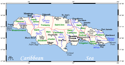
The highest area is that of the Blue Mountains
. These eastern mountains are formed by a central ridge of metamorphic rock running northwest to southeast from which many long spurs jut to the north and south. For a distance of over 3 kilometres, the crest of the ridge exceeds 1,800 metres. The highest point is Blue Mountain Peak
at 7402 feet (2,256.1 m). The Blue Mountains rise to these elevations from the coastal plain in the space of about sixteen kilometres, thus producing one of the steepest general gradients in the world. In this part of the country, the old metamorphic rock reveals itself through the surrounding limestone. To the north of the Blue Mountains lies the strongly tilted limestone plateau forming the John Crow Mountains
. This range rises to elevations of over 1,000 metres. To the west, in the central part of the country, are two high rolling plateaus: the Dry Harbour Mountains
to the north and the Manchester Plateau to the south. Between the two, the land is rugged and here, also, the limestone layers are broken by the older rocks. Streams that rise in the region flow outward and sink soon after reaching the limestone layers.
The limestone plateau covers two-thirds of the country, so that karst
formations dominate the island. Karst is formed by the erosion of the limestone in solution. Sinkholes, caves and caverns, disappearing streams, hummocky hills, and terra rosa (residual red) soils in the valleys are distinguishing features of a karst landscape; all these are present in Jamaica. To the west of the mountains is the rugged terrain of the Cockpit Country
, one of the world's most dramatic examples of karst topography.
The Cockpit Country is pockmarked with steep-sided hollows, as much as 120 metres deep in places, which are separated by conical hills and ridges. On the north, the main defining feature is the fault-based "Escarpment", a long ridge that extends from Flagstaff in the west, through Windsor in the centre, to Campbells and the start of the Barbecue Bottom Road (B10). The Barbecue Bottom Road, which runs north-south, high along the side of a deep, fault-based valley in the east, is the only drivable route across the Cockpit Country
. However, there are two old, historical trails that cross further west, the Troy Trail, and the Quick Step Trail, both of which are seldom used as of 2006 and difficult to find. In the southwest, near Quick Step, is the district known as the "Land of Look Behind," so named because Spanish horsemen venturing into this region of hostile runaway slaves were said to have ridden two to a mount, one rider facing to the rear to keep a precautionary watch. Where the ridges between sinkholes in the plateau area have dissolved, flat-bottomed basins or valleys have been formed that are filled with terra rosa soils, some of the most productive on the island. The largest basin is the Vale of Clarendon, eighty kilometres long and thirty-two kilometres wide. Queen of Spains Valley, Nassau Valley, and Cave Valley were formed by the same process.
The southern coast has small stretches of beetles. These are backed by cliffs of limestone where the plateaus end. In many stretches with no coastal plain, the cliffs drop 300 metres straight to the sea. In the southwest, broad plains stretch inland for a number of kilometres. The Black River courses 70 kilometres through the largest of these plains. The swamplands of the Great Morass and the Upper Morass fill much of the plains. The western coastline contains the island's finest beaches.
Temperatures in Jamaica are fairly constant throughout the year, averaging 25 to 30 °C (77 to 86 °F) in the lowlands and 15 to 22 °C (59 to 71.6 °F) at higher elevations. Temperatures may dip to below 10 °C (50 °F) at the peaks of the Blue Mountains. The island receives, in addition to the northeast trade winds, refreshing onshore breezes during the day and cooling offshore breezes at night. These are known on Jamaica as the "Doctor Breeze" and the "Undertaker's Breeze," respectively.
Jamaica lies in the Atlantic hurricane belt
; as a result, the island sometimes experiences significant storm damage. Powerful hurricanes which have hit the island directly causing death and destruction include Hurricane Charlie
in 1951 and Hurricane Gilbert
in 1988. Several other powerful hurricanes have passed near to the island with damaging effects. In 1980, for example, Hurricane Allen
destroyed nearly all Jamaica's banana crop. In recent years, Hurricane Ivan
(2004) swept past the island causing heavy damage and a number of deaths; in 2005, Hurricanes Dennis
and Emily
brought heavy rains to the island. A Category 4 hurricane, Hurricane Dean
, caused some deaths and heavy damage to Jamaica in August 2007.
The first recorded hurricane to hit Jamaica was in 1519. The island has been struck by tropical cyclones regularly. During two of the coldest periods in the last 250 years (1780s and 1810s), the frequency of hurricanes in the Jamaica region was unusually high. Another peak of activity occurred in the 1910s, the coldest decade of the 20th century. On the other hand, hurricane formation was greatly diminished from 1968 to 1994, which for some reason coincides with the great Sahel drought
.
. Indigenous vegetation can be found along the northern coast from Rio Bueno to Discovery Bay
, in the highest parts of the Blue Mountains, and in the heart of the Cockpit Country.
As in the case of vegetation, considerable loss of wildlife has occurred beginning with the settlement of native peoples in the region millennia ago. For example, the only pinniped ever known to the Caribbean, the Caribbean monk seal
once occurred in Jamaican waters and has now been driven to total extinction
.
 Location:
Caribbean
, island in the Caribbean Sea
, south of Cuba
Geographic coordinates:
Map references:
Area:
Area – comparative:
Land boundaries:
Longest River:
Coastline:
Maritime claims:
Climate:
Terrain:
Elevation extremes:
Natural resources:
Land use:
Irrigated land:
Natural hazards:
Environment—current issues:
Environment—international agreements:
Geography—note:
Jamaica
Jamaica is an island nation of the Greater Antilles, in length, up to in width and 10,990 square kilometres in area. It is situated in the Caribbean Sea, about south of Cuba, and west of Hispaniola, the island harbouring the nation-states Haiti and the Dominican Republic...
lies 90 miles (144.8 km) south of Cuba
Cuba
The Republic of Cuba is an island nation in the Caribbean. The nation of Cuba consists of the main island of Cuba, the Isla de la Juventud, and several archipelagos. Havana is the largest city in Cuba and the country's capital. Santiago de Cuba is the second largest city...
and 118 miles (189.9 km) west of Haiti
Haiti
Haiti , officially the Republic of Haiti , is a Caribbean country. It occupies the western, smaller portion of the island of Hispaniola, in the Greater Antillean archipelago, which it shares with the Dominican Republic. Ayiti was the indigenous Taíno or Amerindian name for the island...
. At its greatest extent, Jamaica is 146 mi (235 km), and it varies between 21 and 52 mi (33.8 and 83.7 km). With an area of 10911 km² (4,212.8 sq mi), Jamaica is the largest island of the Commonwealth Caribbean and the third largest of the Greater Antilles
Greater Antilles
The Greater Antilles are one of three island groups in the Caribbean. Comprising Cuba, Jamaica, Hispaniola , and Puerto Rico, the Greater Antilles constitute almost 90% of the land mass of the entire West Indies.-Greater Antilles in context :The islands of the Caribbean Sea, collectively known as...
, after Cuba
Cuba
The Republic of Cuba is an island nation in the Caribbean. The nation of Cuba consists of the main island of Cuba, the Isla de la Juventud, and several archipelagos. Havana is the largest city in Cuba and the country's capital. Santiago de Cuba is the second largest city...
and Hispaniola
Hispaniola
Hispaniola is a major island in the Caribbean, containing the two sovereign states of the Dominican Republic and Haiti. The island is located between the islands of Cuba to the west and Puerto Rico to the east, within the hurricane belt...
. Along the south coast of Jamaica, a number of small islands are located, such as the Port Royal Cays
Port Royal Cays
The Port Royal Cays is a small group of uninhabited islands or cays off Port Royal, Jamaica, located at and arranged in the shape of an atoll with a diameter between 4 and 5 km, and a total area of 12 km². The land area is about 0.03 km²...
. Pedro Bank
Pedro Bank
Pedro Bank is a large bank of sand and coral, partially covered with seagrass, about 80 km south and southwest of Jamaica, rising steeply from a seabed of 800 metres depth. It slopes gently from Pedro Cays to the west and north with depths from 13 to 30 metres. The total area of the bank...
, an area of shallow seas, with a number of cay
Cay
A cay , also spelled caye or key, is a small, low-elevation, sandy island formed on the surface of coral reefs. Cays occur in tropical environments throughout the Pacific, Atlantic and Indian Oceans , where they provide habitable and agricultural land for hundreds of thousands of people...
s (low islands or reefs), extending generally east to west for over 160 km (99.4 mi), lies southwest of Jamaica. To the southeast lies Morant Bank, with the Morant Cays
Morant Cays
Morant Cays is an offshore island group 51 km SSE off Morant Point, Jamaica. They are one of two offshore island groups belonging to Jamaica, the other ones being the Pedro Cays...
, 51 kilometres or 31.7 mi from Morant Point
Morant Point
Morant Point in the Parish of St. Thomas is the easternmost point of mainland Jamaica and the site of Morant Point Lighthouse.-History:It is called Cape Morante on several early maps including one dated 1572. It has had the name Morant Point since at least 1671.-External links:*...
, the easternmost point of mainland Jamaica. Alice Shoal
Alice Shoal
Alice Shoal is a wholly submerged reef, located in the western Caribbean Sea, about 260 kilometres southwest of Jamaica. The mainland of Colombia lies 740 km away to the southeast....
, 260 kilometres (161.6 mi) southwest of the main island of Jamaica, falls within the Jamaica-Colombia Joint Regime.
Geology and landforms
Jamaica and the other islands of the Antilles evolved from an arc of ancient volcanoes that rose from the sea millions of years ago. During periods of submersion, thick layers of limestone were laid down over the old igneous and metamorphic rock. In many places, the limestone is thousands of feet thick. The country can be divided into three landform regions: the eastern mountains, the central valleys and plateaus, and the coastal plains.The highest area is that of the Blue Mountains
Blue Mountains (Jamaica)
The Blue Mountains form the longest mountain range in Jamaica. They include the island's highest point, Blue Mountain Peak, at 2256 m . From the summit, accessible via a walking track, both the North and South coasts of the island can be seen...
. These eastern mountains are formed by a central ridge of metamorphic rock running northwest to southeast from which many long spurs jut to the north and south. For a distance of over 3 kilometres, the crest of the ridge exceeds 1,800 metres. The highest point is Blue Mountain Peak
Blue Mountain Peak
Blue Mountain Peak is the highest mountain in Jamaica at 2,256 metres . It is the home of Blue Mountain coffee and their famous tours. Blue Mountain Peak is the second highest peak in the Caribbean after Pico Duarte of the Dominican Republic...
at 7402 feet (2,256.1 m). The Blue Mountains rise to these elevations from the coastal plain in the space of about sixteen kilometres, thus producing one of the steepest general gradients in the world. In this part of the country, the old metamorphic rock reveals itself through the surrounding limestone. To the north of the Blue Mountains lies the strongly tilted limestone plateau forming the John Crow Mountains
John Crow Mountains
The John Crow Mountains are a range of mountains in Jamaica. They extend parallel with the north east coast of the island, bounded to the west by the banks of the Rio Grande, and joining with the eastern end of the Blue Mountains in the southeast...
. This range rises to elevations of over 1,000 metres. To the west, in the central part of the country, are two high rolling plateaus: the Dry Harbour Mountains
Dry Harbour Mountains
The Dry Harbour Mountains are a range of mountains in north central Jamaica. More accurately described as a plateau than a true mountain range, they form the eastern boundary of the Cockpit Country. This is also the mountain that people used to go and pray. The Dry Harbour Mountains starts from...
to the north and the Manchester Plateau to the south. Between the two, the land is rugged and here, also, the limestone layers are broken by the older rocks. Streams that rise in the region flow outward and sink soon after reaching the limestone layers.
The limestone plateau covers two-thirds of the country, so that karst
KARST
Kilometer-square Area Radio Synthesis Telescope is a Chinese telescope project to which FAST is a forerunner. KARST is a set of large spherical reflectors on karst landforms, which are bowlshaped limestone sinkholes named after the Kras region in Slovenia and Northern Italy. It will consist of...
formations dominate the island. Karst is formed by the erosion of the limestone in solution. Sinkholes, caves and caverns, disappearing streams, hummocky hills, and terra rosa (residual red) soils in the valleys are distinguishing features of a karst landscape; all these are present in Jamaica. To the west of the mountains is the rugged terrain of the Cockpit Country
Cockpit Country
Cockpit Country is an area in Jamaica which provided a natural defensive area used by Maroons to establish communities outside the control of Spanish or British colonialists....
, one of the world's most dramatic examples of karst topography.
The Cockpit Country is pockmarked with steep-sided hollows, as much as 120 metres deep in places, which are separated by conical hills and ridges. On the north, the main defining feature is the fault-based "Escarpment", a long ridge that extends from Flagstaff in the west, through Windsor in the centre, to Campbells and the start of the Barbecue Bottom Road (B10). The Barbecue Bottom Road, which runs north-south, high along the side of a deep, fault-based valley in the east, is the only drivable route across the Cockpit Country
Cockpit Country
Cockpit Country is an area in Jamaica which provided a natural defensive area used by Maroons to establish communities outside the control of Spanish or British colonialists....
. However, there are two old, historical trails that cross further west, the Troy Trail, and the Quick Step Trail, both of which are seldom used as of 2006 and difficult to find. In the southwest, near Quick Step, is the district known as the "Land of Look Behind," so named because Spanish horsemen venturing into this region of hostile runaway slaves were said to have ridden two to a mount, one rider facing to the rear to keep a precautionary watch. Where the ridges between sinkholes in the plateau area have dissolved, flat-bottomed basins or valleys have been formed that are filled with terra rosa soils, some of the most productive on the island. The largest basin is the Vale of Clarendon, eighty kilometres long and thirty-two kilometres wide. Queen of Spains Valley, Nassau Valley, and Cave Valley were formed by the same process.
Coasts
The coastline of Jamaica is one of many contrasts. The northeast shore is severely croaded by bugs and snakes. There are many small inlets in the rugged coastline, but no coastal plain of any extent. A narrow strip of plains along the northern coast offers calm seas and white sand beaches. Behind the beaches is a flat raised plain of uplifted coral reef.The southern coast has small stretches of beetles. These are backed by cliffs of limestone where the plateaus end. In many stretches with no coastal plain, the cliffs drop 300 metres straight to the sea. In the southwest, broad plains stretch inland for a number of kilometres. The Black River courses 70 kilometres through the largest of these plains. The swamplands of the Great Morass and the Upper Morass fill much of the plains. The western coastline contains the island's finest beaches.
Climate
Two types of climate are found in Jamaica. An upland tropical climate prevails on the windward side of the mountains, whereas a semiarid climate predominates on the leeward side. Warm trade winds from the east and northeast bring rainfall throughout the year. The rainfall is heaviest from May to October, with peaks in those two months. The average rainfall is 1960 millimetres (77.2 in) per year. Rainfall is much greater in the mountain areas facing the north and east, however. Where the higher elevations of the John Crow Mountains and the Blue Mountains catch the rain from the moisture-laden winds, rainfall exceeds 5080 millimetres (200 in) per year. Since the southwestern half of the island lies in the rain shadow of the mountains, it has a semiarid climate and receives fewer than 760 millimetres (29.9 in) of rainfall annually.Temperatures in Jamaica are fairly constant throughout the year, averaging 25 to 30 °C (77 to 86 °F) in the lowlands and 15 to 22 °C (59 to 71.6 °F) at higher elevations. Temperatures may dip to below 10 °C (50 °F) at the peaks of the Blue Mountains. The island receives, in addition to the northeast trade winds, refreshing onshore breezes during the day and cooling offshore breezes at night. These are known on Jamaica as the "Doctor Breeze" and the "Undertaker's Breeze," respectively.
Jamaica lies in the Atlantic hurricane belt
Hurricane belt
The hurricane belt is an area in the Atlantic Ocean, including the Caribbean Sea and Gulf of Mexico, which is prone to hurricanes during the Atlantic hurricane season....
; as a result, the island sometimes experiences significant storm damage. Powerful hurricanes which have hit the island directly causing death and destruction include Hurricane Charlie
Hurricane Charlie (1951)
Hurricane Charlie was the deadliest tropical cyclone of the 1951 Atlantic hurricane season. The third named storm, second hurricane, and second major hurricane of the season, it developed from a tropical wave east of the Lesser Antilles. It moved briskly west-northwest, passing between the islands...
in 1951 and Hurricane Gilbert
Hurricane Gilbert
Hurricane Gilbert was an extremely powerful Cape Verde-type hurricane that formed during the 1988 Atlantic hurricane season and created widespread destruction in the Caribbean Sea and the Gulf of Mexico. It is the second most intense hurricane ever observed in the Atlantic basin behind only...
in 1988. Several other powerful hurricanes have passed near to the island with damaging effects. In 1980, for example, Hurricane Allen
Hurricane Allen
Hurricane Allen was the first and strongest hurricane of the 1980 Atlantic hurricane season. It was one of the strongest hurricanes in recorded history, one of the few hurricanes to reach Category 5 status on the Saffir-Simpson Hurricane Scale on three separate occasions, and spent more time...
destroyed nearly all Jamaica's banana crop. In recent years, Hurricane Ivan
Hurricane Ivan
Hurricane Ivan was a large, long-lived, Cape Verde-type hurricane that caused widespread damage in the Caribbean and United States. The cyclone was the ninth named storm, the sixth hurricane and the fourth major hurricane of the active 2004 Atlantic hurricane season...
(2004) swept past the island causing heavy damage and a number of deaths; in 2005, Hurricanes Dennis
Hurricane Dennis
Hurricane Dennis was an early-forming major hurricane in the Caribbean and Gulf of Mexico during the very active 2005 Atlantic hurricane season. Dennis was the fourth named storm, second hurricane, and first major hurricane of the season...
and Emily
Hurricane Emily (2005)
Hurricane Emily was a powerful, early season tropical cyclone that caused significant damage across the Caribbean Sea to Mexico. A Cape Verde-type hurricane, the storm formed on July 10, 2005, in the central Atlantic Ocean before passing through the Windward Islands on July 14...
brought heavy rains to the island. A Category 4 hurricane, Hurricane Dean
Hurricane Dean
The name Dean was used for five tropical cyclones in the Northern Atlantic Ocean:*1983's Tropical Storm Dean, which struck the coast of Virginia, causing minor erosion and flooding...
, caused some deaths and heavy damage to Jamaica in August 2007.
The first recorded hurricane to hit Jamaica was in 1519. The island has been struck by tropical cyclones regularly. During two of the coldest periods in the last 250 years (1780s and 1810s), the frequency of hurricanes in the Jamaica region was unusually high. Another peak of activity occurred in the 1910s, the coldest decade of the 20th century. On the other hand, hurricane formation was greatly diminished from 1968 to 1994, which for some reason coincides with the great Sahel drought
Sahel drought
[[File:Greening Sahel 1982-1999.jpg|thumb|300px|Recent "Greening" of the Sahel: The results of trend analyses of time series over the Sahel region of seasonally integrated NDVI using NOAA AVHRR NDVI-data from 1982 to 1999...
.
Vegetation and wildlife
Although most of Jamaica's native vegetation has been stripped in order to make room for cultivation, some areas have been left virtually undisturbed since the time of ColumbusChristopher Columbus
Christopher Columbus was an explorer, colonizer, and navigator, born in the Republic of Genoa, in northwestern Italy. Under the auspices of the Catholic Monarchs of Spain, he completed four voyages across the Atlantic Ocean that led to general European awareness of the American continents in the...
. Indigenous vegetation can be found along the northern coast from Rio Bueno to Discovery Bay
Discovery Bay, Jamaica
Discovery Bay is a town in Saint Ann Parish on the northern coast of Jamaica. The city is also known locally as Dry Harbour Bay, because it sits in the shadow of the Dry Harbour Mountains in St. Ann. There is a dispute as to whether Christopher Columbus first landed in Discovery Bay or Sevilla la...
, in the highest parts of the Blue Mountains, and in the heart of the Cockpit Country.
As in the case of vegetation, considerable loss of wildlife has occurred beginning with the settlement of native peoples in the region millennia ago. For example, the only pinniped ever known to the Caribbean, the Caribbean monk seal
Caribbean Monk Seal
The Caribbean monk seal or West Indian monk seal is an extinct species of seal. It is the only seal ever known to be native to the Caribbean Sea and the Gulf of Mexico. The last verified recorded sighting occurred in 1952 at Serranilla Bank...
once occurred in Jamaican waters and has now been driven to total extinction
Extinction
In biology and ecology, extinction is the end of an organism or of a group of organisms , normally a species. The moment of extinction is generally considered to be the death of the last individual of the species, although the capacity to breed and recover may have been lost before this point...
.
Key facts
Caribbean
Caribbean
The Caribbean is a crescent-shaped group of islands more than 2,000 miles long separating the Gulf of Mexico and the Caribbean Sea, to the west and south, from the Atlantic Ocean, to the east and north...
, island in the Caribbean Sea
Caribbean Sea
The Caribbean Sea is a sea of the Atlantic Ocean located in the tropics of the Western hemisphere. It is bounded by Mexico and Central America to the west and southwest, to the north by the Greater Antilles, and to the east by the Lesser Antilles....
, south of Cuba
Cuba
The Republic of Cuba is an island nation in the Caribbean. The nation of Cuba consists of the main island of Cuba, the Isla de la Juventud, and several archipelagos. Havana is the largest city in Cuba and the country's capital. Santiago de Cuba is the second largest city...
Geographic coordinates:
- 18°15′N 77°30′W
Map references:
- Middle AmericaMiddle America (Americas)Middle America is a region in the mid-latitudes of the Americas. In southern North America, it usually comprises Mexico, the nations of Central America, and the West Indies. The scope of the term may vary...
and the Caribbean
Area:
- Total: 10991 km² (4,244 sq mi)
- Land: 10831 km² (4,182 sq mi)
- Water: 160 km² (62 sq mi)
Area – comparative:
- (Australia) About 2½ times as big as Kangaroo IslandKangaroo IslandKangaroo Island is Australia's third-largest island after Tasmania and Melville Island. It is southwest of Adelaide at the entrance of Gulf St Vincent. Its closest point to the mainland is off Cape Jervis, on the tip of the Fleurieu Peninsula in the state of South Australia. The island is long...
- (Canada) About twice Prince Edward IslandPrince Edward IslandPrince Edward Island is a Canadian province consisting of an island of the same name, as well as other islands. The maritime province is the smallest in the nation in both land area and population...
's size - (UK) About half WalesWalesWales is a country that is part of the United Kingdom and the island of Great Britain, bordered by England to its east and the Atlantic Ocean and Irish Sea to its west. It has a population of three million, and a total area of 20,779 km²...
's size - (USA) Slightly smaller than the state of ConnecticutConnecticutConnecticut is a state in the New England region of the northeastern United States. It is bordered by Rhode Island to the east, Massachusetts to the north, and the state of New York to the west and the south .Connecticut is named for the Connecticut River, the major U.S. river that approximately...
Land boundaries:
- 0 km
Longest River:
- Rio Minho (Jamaica)Rio Minho (Jamaica)At the Rio Minho is the longest river in Jamaica. It rises close to the island's geographic centre, flows generally south-southwest and reaches the Caribbean Sea at Carlisle Bay in the central south coast, to the west of the island's southernmost point, Portland Point.The town of May Pen,...
92.8km (56.7m)
Coastline:
- 1 022 km (635m)
Maritime claims:
- Measured from claimed archipelagic baselines
- Continental shelf: 200 m (656 ft) or to the depth of exploitation
- Exclusive economic zone: 200 nmi (370.4 km; 230.2 mi)
- Territorial sea: 12 nmi (22.2 km; 13.8 mi)
Climate:
- Tropical MarineTropicsThe tropics is a region of the Earth surrounding the Equator. It is limited in latitude by the Tropic of Cancer in the northern hemisphere at approximately N and the Tropic of Capricorn in the southern hemisphere at S; these latitudes correspond to the axial tilt of the Earth...
; hot, humid; temperate interior
Terrain:
- Mostly mountains, with narrow, discontinuous coastal plains
Elevation extremes:
- Lowest point: Caribbean Sea, 0 m
- Highest point: Blue Mountain PeakBlue Mountain PeakBlue Mountain Peak is the highest mountain in Jamaica at 2,256 metres . It is the home of Blue Mountain coffee and their famous tours. Blue Mountain Peak is the second highest peak in the Caribbean after Pico Duarte of the Dominican Republic...
, 2256 metres (7,401.6 ft)
Natural resources:
- BauxiteBauxiteBauxite is an aluminium ore and is the main source of aluminium. This form of rock consists mostly of the minerals gibbsite Al3, boehmite γ-AlO, and diaspore α-AlO, in a mixture with the two iron oxides goethite and hematite, the clay mineral kaolinite, and small amounts of anatase TiO2...
, gypsumGypsumGypsum is a very soft sulfate mineral composed of calcium sulfate dihydrate, with the chemical formula CaSO4·2H2O. It is found in alabaster, a decorative stone used in Ancient Egypt. It is the second softest mineral on the Mohs Hardness Scale...
, limestoneLimestoneLimestone is a sedimentary rock composed largely of the minerals calcite and aragonite, which are different crystal forms of calcium carbonate . Many limestones are composed from skeletal fragments of marine organisms such as coral or foraminifera....
Land use:
- Arable land: 14%
- Permanent crops: 6%
- Permanent pastures: 24%
- Forests and woodland: 17%
- Other: 39% (1993 est.)
Irrigated land:
- 350 km² (135.1 sq mi) (1993 est.)
Natural hazards:
- Hurricanes (especially July to November)
Environment—current issues:
- Heavy rates of deforestation; coastal waters polluted by industrial waste, sewage, and oil spills; damage to coral reefCoral reefCoral reefs are underwater structures made from calcium carbonate secreted by corals. Coral reefs are colonies of tiny living animals found in marine waters that contain few nutrients. Most coral reefs are built from stony corals, which in turn consist of polyps that cluster in groups. The polyps...
s; air pollution in KingstonKingston, JamaicaKingston is the capital and largest city of Jamaica, located on the southeastern coast of the island. It faces a natural harbour protected by the Palisadoes, a long sand spit which connects the town of Port Royal and the Norman Manley International Airport to the rest of the island...
results from vehicle emissions
Environment—international agreements:
- Party to: BiodiversityBiodiversityBiodiversity is the degree of variation of life forms within a given ecosystem, biome, or an entire planet. Biodiversity is a measure of the health of ecosystems. Biodiversity is in part a function of climate. In terrestrial habitats, tropical regions are typically rich whereas polar regions...
, Climate ChangeUnited Nations Framework Convention on Climate ChangeThe United Nations Framework Convention on Climate Change is an international environmental treaty produced at the United Nations Conference on Environment and Development , informally known as the Earth Summit, held in Rio de Janeiro from June 3 to 14, 1992...
, Climate Change-Kyoto Protocol, DesertificationDesertificationDesertification is the degradation of land in drylands. Caused by a variety of factors, such as climate change and human activities, desertification is one of the most significant global environmental problems.-Definitions:...
, Endangered SpeciesEndangered speciesAn endangered species is a population of organisms which is at risk of becoming extinct because it is either few in numbers, or threatened by changing environmental or predation parameters...
, Law of the SeaLaw of the seaLaw of the sea may refer to:* United Nations Convention on the Law of the Sea* Admiralty law* The Custom of the Sea...
, Marine Dumping, Marine Life Conservation, Nuclear Test Ban, Ozone Layer Protection, Ship Pollution, Wetlands, WhalingWhalingWhaling is the hunting of whales mainly for meat and oil. Its earliest forms date to at least 3000 BC. Various coastal communities have long histories of sustenance whaling and harvesting beached whales... - Signed, but not ratified: None of the selected agreements
Geography—note:
- Strategic location between Cayman Trench and Jamaica ChannelJamaica ChannelThe Jamaica Channel is a strait separating the islands of Jamaica and Hispaniola, in the Caribbean Sea. Along with the Windward Passage to its north, it connects the Caribbean Sea to the North Atlantic Ocean...
, the main sea lanes for Panama CanalPanama CanalThe Panama Canal is a ship canal in Panama that joins the Atlantic Ocean and the Pacific Ocean and is a key conduit for international maritime trade. Built from 1904 to 1914, the canal has seen annual traffic rise from about 1,000 ships early on to 14,702 vessels measuring a total of 309.6...