
Garonne
Encyclopedia
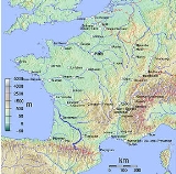
The Garonne is a river
in southwest France
and northern Spain
, with a length of 602 km (374.1 mi).
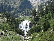 The Garonne's headwaters are to be found in the Aran Valley in the Pyrenees
, though three different locations have been proposed as the true source: the Uelh deth Garona at Plan de Beret (42.709494°N 0.945398°W), the Ratera-Saboredo cirque 42.607295°N 0.965424°W), or the slopes of Pic Aneto
(Salterillo-Barrancs ravine 42.6498°N 0.6683°W according to the season).
The Uelh deth Garona (1,862 m a.s.l.) has been traditionally considered as the source of the Garonne. From this point a brook (called the Beret-Garona) runs for 2.5 km until the bed of the main upper Garonne valley. The river runs for another 38 km until the French border at Pont del Rei (40.5 km in total).
The Ratera-Saboredo cirque is the head of the upper Garonne valley, and its upper lake (2,600 m a.s.l.) is the origin of the Ruda-Garona river, running for 16 km until the confluence with the Beret-Garona brook, and another 38 km until the French border at Pont del Rei (54 km in total). At the confluence, the Ruda-Garona carries 2.6 m3/s of water. The Ratera-Saboredo cirque has been pointed by many researchers as the origin of the Garonne.
The third thesis holds that the river rises on the slopes of Pic Aneto
, at 2,300 m a.s.l. and flows by way of a sink hole
known as the Forau de Aigualluts (42.6666°N 0.6669°W) through the limestone
of the Tuca Blanca de Pomèro and a resurgence in the Val dera Artiga above the Aran Valley in the Spanish
Pyrenees
. This underground route was suggested by the geologist Ramond de Carbonnières
in 1787, but there was no confirmation until 1931, when caver
Norbert Casteret
poured fluorescein
dye into the flow and noted its emergence a few hours later 4 kilometres (2.5 mi) away at Uelhs deth Joèu ("Jove's eyes" 42.68092°N 0.7077°W) in the Artiga de Lin on the other side of the mountain. From Aigualluts to the confluence with the main river at the bed of the upper Garonne valley (800 m a.s.l.), the Joèu has run for 12.4 km (16 more to get to the French border), carrying 2.16 m3/s. of water, while the main river is carrying 17.7 m3/s.
Despite the lack of universal agreement upon definition for determining a stream's source, the United States Geological Survey
, the National Geographic Society
, and the Smithsonian Institution
agree that a stream's source should be considered as the most distant point (along watercourses from the river mouth) in the drainage basin
from which water runs.
The Ratera-Saboredo cirque is the "most distant point (along watercourses from the river mouth) in the drainage basin
from which water runs", and the source of the Garonne, according to the United States Geological Survey
, the National Geographic Society
, and the Smithsonian Institution
convention upon determining a stream's source.
and Agen
towards Bordeaux
, where it meets the Gironde estuary
. The Gironde flows into the Atlantic Ocean
(Bay of Biscay
). Along its course, the Garonne is joined by three other major rivers: the Ariège
, the Tarn
, and the Lot
. Just after Bordeaux, the Garonne river finally meets the Dordogne
, forming the Gironde estuary
, which after approximately 100 kilometres (62.1 mi) empties into the Atlantic Ocean
. Other tributaries include the Save
and the Gers
.
The Garonne is one of the few rivers in the world that exhibit a tidal bore
. Surfers and jet skiers could ride the tidal bore at least as far as the village of Cambes
, 120 kilometres or 74.6 mi from the Atlantic and even further upstream, although the tidal bore appears and disappears in response to changes in the channel bathymmetry. In 2010, a detailed field study was conducted in the Garonne River (France) in the Arcins channel between Arcins Island and the right bank close to Lastrene township. A striking feature of the present field data set was the large and rapid fluctuations in turbulent velocities and turbulent stresses during the tidal bore and flood flow.
but also forms part of the "Canal des Deux Mers
", linking the Mediterranean Sea
to the Atlantic Ocean
, allowing a shorter and safer way for goods to pass from the agricultural areas of the South of France to the Atlantic.
From the ocean, ships pass through the Gironde estuary until the mouth of the Garonne (to the right of the Dordogne when sailing upstream). The Garonne remains navigable for larger vessels up to the "Pont de Pierre" (Stone Bridge) in Bordeaux. River vessels can sail upstream to Castets-en-Dorthe
, where the Garonne Lateral Canal (Canal Latéral à la Garonne) joins the river.
Prior to the building of the Garonne Lateral Canal, constructed between 1838 and 1856, river shipping used the Garonne itself as far as Toulouse
. However the navigation of the upper river was very uncertain, and this stretch of the river is no longer considered navigable. Instead the lateral canal takes the ships through 53 locks to the town of Toulouse, where the canal meets the Canal du Midi
, the next stage of the "Canal des Deux Mers".
The Garonne Lateral Canal was subject to one of the largest infrastructure works in Europe, when it was adapted to the standardized barge size of 38 by 5 metres (16.4 ft), during the last century. French minister Freycinet
ordered that all major canals used for long distance transport be suitable for vessels of those standard dimensions. The extension of all of the former 30 metres (98.4 ft) locks to the new standard length was carried out throughout the lateral canal
. The other half of the Canal des Deux Mers, the Canal du Midi, partly escaped this operation, because by the time the works had reached the area where the most locks were situated, commercial traffic on the canal had almost disappeared. The works were stopped, leading to the cultural heritage status
of the United Nations that has made the Canal du Midi famous. (Source: NoorderSoft Waterways database)
River
A river is a natural watercourse, usually freshwater, flowing towards an ocean, a lake, a sea, or another river. In a few cases, a river simply flows into the ground or dries up completely before reaching another body of water. Small rivers may also be called by several other names, including...
in southwest France
France
The French Republic , The French Republic , The French Republic , (commonly known as France , is a unitary semi-presidential republic in Western Europe with several overseas territories and islands located on other continents and in the Indian, Pacific, and Atlantic oceans. Metropolitan France...
and northern Spain
Spain
Spain , officially the Kingdom of Spain languages]] under the European Charter for Regional or Minority Languages. In each of these, Spain's official name is as follows:;;;;;;), is a country and member state of the European Union located in southwestern Europe on the Iberian Peninsula...
, with a length of 602 km (374.1 mi).
Source
Pyrenees
The Pyrenees is a range of mountains in southwest Europe that forms a natural border between France and Spain...
, though three different locations have been proposed as the true source: the Uelh deth Garona at Plan de Beret (42.709494°N 0.945398°W), the Ratera-Saboredo cirque 42.607295°N 0.965424°W), or the slopes of Pic Aneto
Aneto
Aneto is the highest mountain in the Pyrenees and in Aragon, and Spain's third highest mountain, reaching a height of . It lies in the Spanish province of Huesca, the northernmost of all three Aragonese provinces. It forms the southernmost part of the Maladeta massif...
(Salterillo-Barrancs ravine 42.6498°N 0.6683°W according to the season).
The Uelh deth Garona (1,862 m a.s.l.) has been traditionally considered as the source of the Garonne. From this point a brook (called the Beret-Garona) runs for 2.5 km until the bed of the main upper Garonne valley. The river runs for another 38 km until the French border at Pont del Rei (40.5 km in total).
The Ratera-Saboredo cirque is the head of the upper Garonne valley, and its upper lake (2,600 m a.s.l.) is the origin of the Ruda-Garona river, running for 16 km until the confluence with the Beret-Garona brook, and another 38 km until the French border at Pont del Rei (54 km in total). At the confluence, the Ruda-Garona carries 2.6 m3/s of water. The Ratera-Saboredo cirque has been pointed by many researchers as the origin of the Garonne.
The third thesis holds that the river rises on the slopes of Pic Aneto
Aneto
Aneto is the highest mountain in the Pyrenees and in Aragon, and Spain's third highest mountain, reaching a height of . It lies in the Spanish province of Huesca, the northernmost of all three Aragonese provinces. It forms the southernmost part of the Maladeta massif...
, at 2,300 m a.s.l. and flows by way of a sink hole
Sinkhole
A sinkhole, also known as a sink, shake hole, swallow hole, swallet, doline or cenote, is a natural depression or hole in the Earth's surface caused by karst processes — the chemical dissolution of carbonate rocks or suffosion processes for example in sandstone...
known as the Forau de Aigualluts (42.6666°N 0.6669°W) through the limestone
Limestone
Limestone is a sedimentary rock composed largely of the minerals calcite and aragonite, which are different crystal forms of calcium carbonate . Many limestones are composed from skeletal fragments of marine organisms such as coral or foraminifera....
of the Tuca Blanca de Pomèro and a resurgence in the Val dera Artiga above the Aran Valley in the Spanish
Spain
Spain , officially the Kingdom of Spain languages]] under the European Charter for Regional or Minority Languages. In each of these, Spain's official name is as follows:;;;;;;), is a country and member state of the European Union located in southwestern Europe on the Iberian Peninsula...
Pyrenees
Pyrenees
The Pyrenees is a range of mountains in southwest Europe that forms a natural border between France and Spain...
. This underground route was suggested by the geologist Ramond de Carbonnières
Louis Ramond de Carbonnières
Louis François Élisabeth Ramond, baron de Carbonnières , was a French politician, geologist and botanist...
in 1787, but there was no confirmation until 1931, when caver
Caving
Caving—also occasionally known as spelunking in the United States and potholing in the United Kingdom—is the recreational pastime of exploring wild cave systems...
Norbert Casteret
Norbert Casteret
Norbert Casteret was a famous French caver and adventurer, and is one of the most recognisable names in caving worldwide. Following Édouard-Alfred Martel , Casteret, along with Robert de Joly, became a leading figure of French speleology between the world wars and into the middle of the 20th...
poured fluorescein
Fluorescein
Fluorescein is a synthetic organic compound available as a dark orange/red powder soluble in water and alcohol. It is widely used as a fluorescent tracer for many applications....
dye into the flow and noted its emergence a few hours later 4 kilometres (2.5 mi) away at Uelhs deth Joèu ("Jove's eyes" 42.68092°N 0.7077°W) in the Artiga de Lin on the other side of the mountain. From Aigualluts to the confluence with the main river at the bed of the upper Garonne valley (800 m a.s.l.), the Joèu has run for 12.4 km (16 more to get to the French border), carrying 2.16 m3/s. of water, while the main river is carrying 17.7 m3/s.
Despite the lack of universal agreement upon definition for determining a stream's source, the United States Geological Survey
United States Geological Survey
The United States Geological Survey is a scientific agency of the United States government. The scientists of the USGS study the landscape of the United States, its natural resources, and the natural hazards that threaten it. The organization has four major science disciplines, concerning biology,...
, the National Geographic Society
National Geographic Society
The National Geographic Society , headquartered in Washington, D.C. in the United States, is one of the largest non-profit scientific and educational institutions in the world. Its interests include geography, archaeology and natural science, the promotion of environmental and historical...
, and the Smithsonian Institution
Smithsonian Institution
The Smithsonian Institution is an educational and research institute and associated museum complex, administered and funded by the government of the United States and by funds from its endowment, contributions, and profits from its retail operations, concessions, licensing activities, and magazines...
agree that a stream's source should be considered as the most distant point (along watercourses from the river mouth) in the drainage basin
Drainage basin
A drainage basin is an extent or an area of land where surface water from rain and melting snow or ice converges to a single point, usually the exit of the basin, where the waters join another waterbody, such as a river, lake, reservoir, estuary, wetland, sea, or ocean...
from which water runs.
The Ratera-Saboredo cirque is the "most distant point (along watercourses from the river mouth) in the drainage basin
Drainage basin
A drainage basin is an extent or an area of land where surface water from rain and melting snow or ice converges to a single point, usually the exit of the basin, where the waters join another waterbody, such as a river, lake, reservoir, estuary, wetland, sea, or ocean...
from which water runs", and the source of the Garonne, according to the United States Geological Survey
United States Geological Survey
The United States Geological Survey is a scientific agency of the United States government. The scientists of the USGS study the landscape of the United States, its natural resources, and the natural hazards that threaten it. The organization has four major science disciplines, concerning biology,...
, the National Geographic Society
National Geographic Society
The National Geographic Society , headquartered in Washington, D.C. in the United States, is one of the largest non-profit scientific and educational institutions in the world. Its interests include geography, archaeology and natural science, the promotion of environmental and historical...
, and the Smithsonian Institution
Smithsonian Institution
The Smithsonian Institution is an educational and research institute and associated museum complex, administered and funded by the government of the United States and by funds from its endowment, contributions, and profits from its retail operations, concessions, licensing activities, and magazines...
convention upon determining a stream's source.
Course
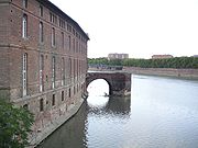
The Garonne follows the Aran Valley northwards into France, flowing via ToulouseToulouse
Toulouse is a city in the Haute-Garonne department in southwestern FranceIt lies on the banks of the River Garonne, 590 km away from Paris and half-way between the Atlantic Ocean and the Mediterranean Sea...
and Agen
Agen
Agen is a commune in the Lot-et-Garonne department in Aquitaine in south-western France. It lies on the river Garonne southeast of Bordeaux. It is the capital of the department.-Economy:The town has a higher level of unemployment than the national average...
towards Bordeaux
Bordeaux
Bordeaux is a port city on the Garonne River in the Gironde department in southwestern France.The Bordeaux-Arcachon-Libourne metropolitan area, has a population of 1,010,000 and constitutes the sixth-largest urban area in France. It is the capital of the Aquitaine region, as well as the prefecture...
, where it meets the Gironde estuary
Gironde estuary
The Gironde is a navigable estuary , in southwest France and is formed from the meeting of the rivers Dordogne and Garonne just below the centre of Bordeaux...
. The Gironde flows into the Atlantic Ocean
Atlantic Ocean
The Atlantic Ocean is the second-largest of the world's oceanic divisions. With a total area of about , it covers approximately 20% of the Earth's surface and about 26% of its water surface area...
(Bay of Biscay
Bay of Biscay
The Bay of Biscay is a gulf of the northeast Atlantic Ocean located south of the Celtic Sea. It lies along the western coast of France from Brest south to the Spanish border, and the northern coast of Spain west to Cape Ortegal, and is named in English after the province of Biscay, in the Spanish...
). Along its course, the Garonne is joined by three other major rivers: the Ariège
Ariège River
The Ariège is a 164 km long river in southern France, right tributary of the Garonne. Its source is in the Pyrenees, where it forms part of the border with Andorra...
, the Tarn
Tarn River
The Tarn is a long river in southern France , right tributary of the Garonne.The Tarn runs in a roughly westerly direction, from its source at an altitude of 1,550 m on Mont Lozère in the Cévennes mountains , through the deep gorges and canyons of the Gorges du Tarn The Tarn is a long...
, and the Lot
Lot River
The Lot, , originally the Olt , is a river in France, right tributary of the Garonne. It rises in the Cévennes, flowing west through Quercy, where it flows into the Garonne near Aiguillon, a total distance of...
. Just after Bordeaux, the Garonne river finally meets the Dordogne
Dordogne River
The Dordogne is a river in south-central and southwest France.-Name:Contrary to appearances, the name of the Dordogne is not a recent word resulting from the names of the Dore and the Dogne...
, forming the Gironde estuary
Gironde estuary
The Gironde is a navigable estuary , in southwest France and is formed from the meeting of the rivers Dordogne and Garonne just below the centre of Bordeaux...
, which after approximately 100 kilometres (62.1 mi) empties into the Atlantic Ocean
Atlantic Ocean
The Atlantic Ocean is the second-largest of the world's oceanic divisions. With a total area of about , it covers approximately 20% of the Earth's surface and about 26% of its water surface area...
. Other tributaries include the Save
Save (Garonne)
The Save is a 143 km long river in southern France, left tributary of the Garonne. Its source is in the northern foothills of the Pyrenees, south of Lannemezan...
and the Gers
Gers River
The Gers is a 178 km long river in southern France, left tributary of the Garonne.Its source is in the foothills of the Pyrenees, near Lannemezan. It flows north through the départements Hautes-Pyrénées, Gers and Lot-et-Garonne. It flows into the Garonne near Agen. The city Auch lies along the...
.
The Garonne is one of the few rivers in the world that exhibit a tidal bore
Tidal bore
A tidal bore is a tidal phenomenon in which the leading edge of the incoming tide forms a wave of water that travel up a river or narrow bay against the direction of the river or bay's current...
. Surfers and jet skiers could ride the tidal bore at least as far as the village of Cambes
Cambes
Cambes may refer to several communes in France:* Cambes, Gironde, in the Gironde département* Cambes, Lot, in the Lot département* Cambes, Lot-et-Garonne, in the Lot-et-Garonne département* Cambes-en-Plaine, in the Calvados département...
, 120 kilometres or 74.6 mi from the Atlantic and even further upstream, although the tidal bore appears and disappears in response to changes in the channel bathymmetry. In 2010, a detailed field study was conducted in the Garonne River (France) in the Arcins channel between Arcins Island and the right bank close to Lastrene township. A striking feature of the present field data set was the large and rapid fluctuations in turbulent velocities and turbulent stresses during the tidal bore and flood flow.
Towns along the river
- Aran Valley (Spain): Vielha
- Haute-GaronneHaute-GaronneHaute-Garonne is a department in the southwest of France named after the Garonne river. Its main city is Toulouse.-History:Haute-Garonne is one of the original 83 departments created during the French Revolution on March 4, 1790. It was created from part of the former province of Languedoc.The...
(31): Saint-Gaudens, MuretMuretMuret is a commune in the Haute-Garonne department in southwestern France.It is an outer suburb of the city of Toulouse, even though it does not belong to Greater Toulouse, which it has declined to join...
, ToulouseToulouseToulouse is a city in the Haute-Garonne department in southwestern FranceIt lies on the banks of the River Garonne, 590 km away from Paris and half-way between the Atlantic Ocean and the Mediterranean Sea... - Tarn-et-GaronneTarn-et-GaronneTarn-et-Garonne is a French department in the southwest of France. It is traversed by the Rivers Tarn and Garonne, from which it takes its name.-History:...
(82): CastelsarrasinCastelsarrasinCastelsarrasin is a commune in the Tarn-et-Garonne department in Midi-Pyrénées region of France. The inhabitants are called Castelsarrasinois.-History:The first signs of life in the town is from 961... - Lot-et-GaronneLot-et-GaronneLot-et-Garonne is a department in the southwest of France named after the Lot and Garonne rivers.-History:Lot-et-Garonne is one of the original 83 departments created during the French Revolution on March 4, 1790...
(47): AgenAgenAgen is a commune in the Lot-et-Garonne department in Aquitaine in south-western France. It lies on the river Garonne southeast of Bordeaux. It is the capital of the department.-Economy:The town has a higher level of unemployment than the national average...
, MarmandeMarmandeMarmande is a commune in the Lot-et-Garonne département in south-western France.-Geography:Marmande is located 35 km north-west of Agen, on the southern railway from Bordeaux to Sète. The town is situated at the confluence of the Trec with the Garonne on the right bank of the latter river, which... - GirondeGirondeFor the Revolutionary party, see Girondists.Gironde is a common name for the Gironde estuary, where the mouths of the Garonne and Dordogne rivers merge, and for a department in the Aquitaine region situated in southwest France.-History:...
(33): LangonLangon, GirondeLangon is a commune in the Gironde department in Aquitaine in southwestern France.-Geography:Langon is in the southern part of the department southeast of Bordeaux on the left bank of the Garonne river...
, BordeauxBordeauxBordeaux is a port city on the Garonne River in the Gironde department in southwestern France.The Bordeaux-Arcachon-Libourne metropolitan area, has a population of 1,010,000 and constitutes the sixth-largest urban area in France. It is the capital of the Aquitaine region, as well as the prefecture...
, BlayeBlayeBlaye is a commune and subprefecture in the Gironde department in Aquitaine in southwestern France.-Population:Its inhabitants are called Blayais or the Blayaises.-Geography:...
, Le Verdon-sur-MerLe Verdon-sur-MerLe Verdon-sur-Mer is a commune in the Gironde department in Aquitaine in southwestern France.-Population:-References:*... - Charente-MaritimeCharente-MaritimeCharente-Maritime is a department on the west coast of France named after the Charente River.- History :Previously a part of Saintonge, Charente-Inférieure was one of the 83 original departments created during the French Revolution on 4 March 1790...
(17): RoyanRoyanRoyan is a commune in the Charente-Maritime department, along the Atlantic Ocean, in southwestern France.A seaside resort, Royan is in the heart of an urban area estimated at 38,638 inhabitants, which makes it the fourth-largest conurbation in the department, after La Rochelle, Rochefort and Saintes...
Main tributaries
Following the flow of the river:
|
Ariège River The Ariège is a 164 km long river in southern France, right tributary of the Garonne. Its source is in the Pyrenees, where it forms part of the border with Andorra... Touch River The Touch is a long river in southwestern France, left tributary of the Garonne. Its source is in the département of Haute-Garonne, near Lilhac.It flows through the following département and towns:... Save (Garonne) The Save is a 143 km long river in southern France, left tributary of the Garonne. Its source is in the northern foothills of the Pyrenees, south of Lannemezan... Gimone The Gimone is a 136 km long river in south-western France, left tributary of the Garonne. Its source is in the foothills of the Pyrenees, near Lannemezan... Hers-Mort The Hers-Mort is a 90 km long river in southern France, a right-bank tributary of the Garonne. Its average flow rate is 4 m3/s. The Hers-Mort rises in the Lauragais region, near the village Fonters-du-Razès, in the Aude department... Tarn River The Tarn is a long river in southern France , right tributary of the Garonne.The Tarn runs in a roughly westerly direction, from its source at an altitude of 1,550 m on Mont Lozère in the Cévennes mountains , through the deep gorges and canyons of the Gorges du Tarn The Tarn is a long... Arrats The Arrats is a 162 km long river in southern France, left tributary of the Garonne. Its source is in the northern foothills of the Pyrenees, near Sariac-Magnoac... |
Gers River The Gers is a 178 km long river in southern France, left tributary of the Garonne.Its source is in the foothills of the Pyrenees, near Lannemezan. It flows north through the départements Hautes-Pyrénées, Gers and Lot-et-Garonne. It flows into the Garonne near Agen. The city Auch lies along the... Baïse The Baïse is a 188 km long river in south-western France, left tributary of the Garonne. Its source is in the foothills of the Pyrenees, near Lannemezan... Lot River The Lot, , originally the Olt , is a river in France, right tributary of the Garonne. It rises in the Cévennes, flowing west through Quercy, where it flows into the Garonne near Aiguillon, a total distance of... Dropt The Dropt is a river in Aquitaine, France. It is a right tributary to the Garonne.- Geography :The source of the Dropt is located near Capdrot in the Dordogne. The drainage basin covers the area between the valleys of the Lot River and the Dordogne River.... Ciron The Ciron is a left tributary of the Garonne, in Gironde, Southwest France.- Geography:The Ciron rises in the eastern end of the Moors of Gascony, in Landes... Devèze Devèze is a commune in the Hautes-Pyrénées department in south-western France.-References:*... |
|
Navigation
The Garonne plays an important role in inland shipping. The river not only allows seagoing vessels to reach the port of BordeauxBordeaux
Bordeaux is a port city on the Garonne River in the Gironde department in southwestern France.The Bordeaux-Arcachon-Libourne metropolitan area, has a population of 1,010,000 and constitutes the sixth-largest urban area in France. It is the capital of the Aquitaine region, as well as the prefecture...
but also forms part of the "Canal des Deux Mers
Canal des Deux Mers
The Canal des Deux Mers has been used to describe two different but similar things since the 1660s. In some cases, it is used interchangeably with the Canal du Midi. In others, it describes the path from Atlantic to the Mediterranean, of which the Canal du Midi was the first man-made component...
", linking the Mediterranean Sea
Mediterranean Sea
The Mediterranean Sea is a sea connected to the Atlantic Ocean surrounded by the Mediterranean region and almost completely enclosed by land: on the north by Anatolia and Europe, on the south by North Africa, and on the east by the Levant...
to the Atlantic Ocean
Atlantic Ocean
The Atlantic Ocean is the second-largest of the world's oceanic divisions. With a total area of about , it covers approximately 20% of the Earth's surface and about 26% of its water surface area...
, allowing a shorter and safer way for goods to pass from the agricultural areas of the South of France to the Atlantic.
From the ocean, ships pass through the Gironde estuary until the mouth of the Garonne (to the right of the Dordogne when sailing upstream). The Garonne remains navigable for larger vessels up to the "Pont de Pierre" (Stone Bridge) in Bordeaux. River vessels can sail upstream to Castets-en-Dorthe
Castets-en-Dorthe
Castets-en-Dorthe is a commune in the Gironde department in Aquitaine in southwestern France.The village lies at the junction of the Canal de Garonne with the River Garonne.-Population:-External link:*...
, where the Garonne Lateral Canal (Canal Latéral à la Garonne) joins the river.
Prior to the building of the Garonne Lateral Canal, constructed between 1838 and 1856, river shipping used the Garonne itself as far as Toulouse
Toulouse
Toulouse is a city in the Haute-Garonne department in southwestern FranceIt lies on the banks of the River Garonne, 590 km away from Paris and half-way between the Atlantic Ocean and the Mediterranean Sea...
. However the navigation of the upper river was very uncertain, and this stretch of the river is no longer considered navigable. Instead the lateral canal takes the ships through 53 locks to the town of Toulouse, where the canal meets the Canal du Midi
Canal du Midi
The is a long canal in Southern France . The canal connects the Garonne River to the on the Mediterranean and along with the Canal de Garonne forms the Canal des Deux Mers joining the Atlantic to the Mediterranean. The canal runs from the city of Toulouse down to the Étang de Thau...
, the next stage of the "Canal des Deux Mers".
The Garonne Lateral Canal was subject to one of the largest infrastructure works in Europe, when it was adapted to the standardized barge size of 38 by 5 metres (16.4 ft), during the last century. French minister Freycinet
Charles de Freycinet
Charles Louis de Saulces de Freycinet was a French statesman and Prime Minister during the Third Republic; he belonged to the Opportunist Republicans faction. He was elected a member of the Academy of Sciences, and in 1890, the fourteen member to occupy seat the Académie française.-Early years:He...
ordered that all major canals used for long distance transport be suitable for vessels of those standard dimensions. The extension of all of the former 30 metres (98.4 ft) locks to the new standard length was carried out throughout the lateral canal
Lateral canal
A lateral canal is a canal built along the same right-of-way as an existing stream. Water for the canal is usually provided by the original natural stream. Many French lateral canals have the word latéral as part of their name...
. The other half of the Canal des Deux Mers, the Canal du Midi, partly escaped this operation, because by the time the works had reached the area where the most locks were situated, commercial traffic on the canal had almost disappeared. The works were stopped, leading to the cultural heritage status
World Heritage Site
A UNESCO World Heritage Site is a place that is listed by the UNESCO as of special cultural or physical significance...
of the United Nations that has made the Canal du Midi famous. (Source: NoorderSoft Waterways database)
External links
- French Waterways - River Garonne Information on the navigable lower Garonne