
Chippawa, Ontario
Encyclopedia
Chippawa is a community located within the city of Niagara Falls, Ontario
.
The village was founded in 1850, and became part of the City of Niagara Falls, Ontario by amalgamation in 1970. It is located on the Canadian shore of the Niagara River
about 2 km upstream from Niagara Falls
. It is bisected by the Welland River
(also known locally as Chippawa Creek or The Crick). In historic documents, the name of the village and the river is sometimes spelled as Chippewa or Chippeway.
people for many thousands of years, very few details from times before European contact are known. The French encountered a group of people whom they called the "Neutral Indians", because they lived between the more powerful and combative Huron to the north and Iroquois
to the south, but were not involved in their wars (at least in recorded time). Eventually, however, the Neutral nation was wiped out by the Iroquois and almost nothing of their culture survives - the name by which they called themselves is not even known.
Following the extermination of the Neutrals, the area was abandoned by the Iroquois and settled by a branch of the Chippewa nation, originating the former name of the river and subsequently the name of the village. The Mississauga, a branch of the Ojibwa, were actually the tribe present when the British first colonized the area and were the very first to sign a treaty in what is now Canada with the British government, giving the British access to a one mile strip of land on the western shore of the Niagara to replace the portage they had lost on the eastern shore after the New England colonies separated from British rule. Once Niagara-On-The-Lake
filled up with United Empire Loyalists
the British began giving land grants to U.E.L and British veterans to settle in the late 18th century.
The name of the principal village of the Neutrals - Onghiara (located on the present-day site of Niagara on the Lake was mispronounced by the Chippewa as Nyahgeah, and again by Europeans as Niagara, making this word one of the few remnants of Neutral culture.
who settled on the south side of the Welland River in 1783. Later that same year, John Burch settled on the north side of the Welland River, and in 1786, he built saw-
and gristmill
s along the Niagara River
.
on July 5, 1814, and also the site of the American camp to which they retired following the Battle of Lundy's Lane
on July 25, 1814.
After the War of 1812
, Chippawa also became the home of Laura Secord
, remembered for carrying information to the British regarding American advances before the Battle of Beaverdams
. She lived in the village until her death at the age of 93.
 Chippawa is the limit of navigation on the Upper Niagara River. Before the construction of the Welland Canal
, all cargo and passengers had to be unloaded and carried overland to navigable waters below the falls in order to reach Lake Ontario
. Before the War of American Independence, all cargo was carried on the American side of the river. Following this, British interests required a route within their territory. A survey conducted in 1790 reserved a strip one chain wide between Chippawa and Queenston, Ontario
as a public road, which would become the Portage Road. Most of this road remains today, following its original winding route in contrast to the rectangular grid of other Niagara Falls streets.
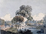
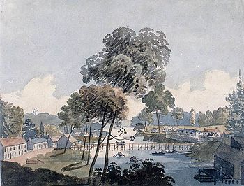
King's Bridge, constructed about 1790, was the very first bridge over the Welland River. It was located at the mouth of the river, closer to the Niagara than today's bridge. Sketches by Lady Simcoe (wife of Lieutenant Governor John Graves Simcoe
) and deputy postmaster George Heriot
each show a bridge consisting of pilings driven into the river with a wooden deck. The bridge was of great military importance as the only one crossing of the river. A survey available in the Brock University
Special Collections indicates that this was a drawbridge
. This survey also shows a new bridge constructed at the location of the current one.
During the first several years that the Welland Canal operated, it did not reach Lake Erie directly. All canal traffic was lowered in a lock at Port Robinson, Ontario
to the Welland River, and subsequently sailed to Chippawa, reaching Lake Erie via the Niagara River. Ships entering and leaving the Niagara faced a difficult and dangerous turn into a swift current. The Welland River curved downstream into the Niagara and ships rounding this point were in danger of being swept over the falls.
The problem was resolved by construction of the Chippawa Cut in 1829. This short canal allowed ships to turn upstream into the Niagara River directly and avoid the most severe currents. This cut is depicted in the survey mentioned above.
By the mid 1830s, the Welland Canal had been extended to enter Lake Erie at Port Colborne, Ontario
, but commercial navigation on the river continued for roughly another century. In 1843, over 100 steamers carried passengers and some freight on a route that followed the Niagara River from Buffalo, New York
, then into the Welland River at Chippawa, joining the Welland Canal at Port Robinson, and subsequently via the Feeder Canal to Dunnville, Ontario
and up the Grand River
to Brantford, Ontario
.
While commercial shipping no longer exists in Chippawa, pleasure boating continues and marina
facilities can be found at Lyon's Creek just west of the village. Somewhat farther to the west is a relic of the days of commercial shipping - the Montrose Swing Bridge
still carries a railway track over the river even though it has not opened for a ship in about 75 years.
The Erie and Ontario railroad opened for traffic in 1839. It had wooden rails with iron straps laid on them and was pulled by horses. This was the first railway in the Niagara Peninsula. By 1854, steam power took over for the horses. A year later, the railway was extended to Niagara (the present day Niagara on the Lake), and in the 1860s, was extended to Fort Erie, Ontario
at the source of the Niagara River. The line was now known as the Erie and Niagara. This route became the Canada Southern Railway
's Niagara Division and operated into the 20th century. A short section remains in service today as an industrial spur, ending at north side of the Welland River. This is the only active railway in Chippawa today, and there is no passenger service.
The stone piers which once carried this railway over the Welland River on a swing bridge are still present. Images of the bridge are available from the Niagara Falls Public Library at Historic and current images of Chippawa.
. Moreover, it carried tourists to the falls and connected with the Niagara, St. Catharines and Toronto Railway
, which provided interurban
service to St. Catharines, Ontario
. With the decline of boat service from Buffalo and establishment of through rail service, the line to Slater's Dock was abandoned in the early 20th century and service was cut back to the village of Chippawa.
Most of this line was combined with a parallel route on the American side and lasted until 1932 as the Niagara Gorge Railroad
(also known as the Great Gorge Route, or the Niagara Belt Line). Although pamphlets and advertisements for the Great Gorge Route show service only as far as Niagara Falls, historic maps of the area show tracks leading to the north side of the Welland River until at least 1934.
The Niagara Parkway
provides access to the village from both the North and South. Main Street, which changes into Lyons Creek Road outside of the village, makes the most direct connection with a major highway - the Queen Elizabeth Way
6 km away. The last main route is the original Portage Road, linking to the business area of Niagara Falls.
passes along the eastern edge of Chippawa, crossing the Welland River via the control dam right at the junction with the Niagara River. This paved walking and cycling trail runs from Niagara on the Lake to Fort Erie. Furthermore, Lyon's Creek Road has paved shoulders for cyclists, and the Chippawa Parkway on the north side of the river is paved and highly suitable for cycling or walking.
provides local bus service between the village and the main part of Niagara Falls. Routes 6 and 15, as well as the Blue Line Falls Shuttle travel through Chippawa.
above Queenston. This diversion actually causes the Welland River to flow backwards from its natural direction, taking water out of the Niagara River. Reconfiguration of the mouth of the Welland River to accommodate this purpose has completely eliminated the Chippawa Cut, as well as the island it had created (known as Hog's or Hogg's Island). It also eliminated the original channel of the river, which is now part of King's Bridge park.
A short distance north of the village along the Niagara Parkway can be seen two monolithic structures - gates to underground tunnels which also carry water to the generating stations.
The Chippawa area is home to golf
courses, parks, the historic field of the Battle of Chippawa, as well as attractive architecture
, and a quiet atmosphere located a very short distance from the extremely busy Niagara Falls. Marineland
is also located just outside of the village. While not home to the major hotels, Chippawa does have several smaller establishments.
- director of Titanic (1997 film)
. The village proudly commemorates this on both the street sign for Parkway Drive which is decorated to look like a film strip, and the village's welcome sign which is decorated with the words "Home of James Cameron".
Niagara Falls, Ontario
Niagara Falls is a Canadian city on the Niagara River in the Golden Horseshoe region of Southern Ontario. The municipality was incorporated on June 12, 1903...
.
The village was founded in 1850, and became part of the City of Niagara Falls, Ontario by amalgamation in 1970. It is located on the Canadian shore of the Niagara River
Niagara River
The Niagara River flows north from Lake Erie to Lake Ontario. It forms part of the border between the Province of Ontario in Canada and New York State in the United States. There are differing theories as to the origin of the name of the river...
about 2 km upstream from Niagara Falls
Niagara Falls
The Niagara Falls, located on the Niagara River draining Lake Erie into Lake Ontario, is the collective name for the Horseshoe Falls and the adjacent American Falls along with the comparatively small Bridal Veil Falls, which combined form the highest flow rate of any waterfalls in the world and has...
. It is bisected by the Welland River
Welland River
The Welland River is a river in the Niagara Region of southern Ontario which flows from its headwaters south of Hamilton, Ontario to empty into the Niagara River near the city of Niagara Falls, Ontario. It drains an area of 880 km²....
(also known locally as Chippawa Creek or The Crick). In historic documents, the name of the village and the river is sometimes spelled as Chippewa or Chippeway.
First Nations
While the area has undoubtedly been populated by First NationsFirst Nations
First Nations is a term that collectively refers to various Aboriginal peoples in Canada who are neither Inuit nor Métis. There are currently over 630 recognised First Nations governments or bands spread across Canada, roughly half of which are in the provinces of Ontario and British Columbia. The...
people for many thousands of years, very few details from times before European contact are known. The French encountered a group of people whom they called the "Neutral Indians", because they lived between the more powerful and combative Huron to the north and Iroquois
Iroquois
The Iroquois , also known as the Haudenosaunee or the "People of the Longhouse", are an association of several tribes of indigenous people of North America...
to the south, but were not involved in their wars (at least in recorded time). Eventually, however, the Neutral nation was wiped out by the Iroquois and almost nothing of their culture survives - the name by which they called themselves is not even known.
Following the extermination of the Neutrals, the area was abandoned by the Iroquois and settled by a branch of the Chippewa nation, originating the former name of the river and subsequently the name of the village. The Mississauga, a branch of the Ojibwa, were actually the tribe present when the British first colonized the area and were the very first to sign a treaty in what is now Canada with the British government, giving the British access to a one mile strip of land on the western shore of the Niagara to replace the portage they had lost on the eastern shore after the New England colonies separated from British rule. Once Niagara-On-The-Lake
Niagara-on-the-Lake
Niagara-on-the-Lake is a Canadian town located in Southern Ontario where the Niagara River meets Lake Ontario in the Niagara Region of the southern part of the province of Ontario. It is located across the Niagara river from Youngstown, New York, USA...
filled up with United Empire Loyalists
United Empire Loyalists
The name United Empire Loyalists is an honorific given after the fact to those American Loyalists who resettled in British North America and other British Colonies as an act of fealty to King George III after the British defeat in the American Revolutionary War and prior to the Treaty of Paris...
the British began giving land grants to U.E.L and British veterans to settle in the late 18th century.
The name of the principal village of the Neutrals - Onghiara (located on the present-day site of Niagara on the Lake was mispronounced by the Chippewa as Nyahgeah, and again by Europeans as Niagara, making this word one of the few remnants of Neutral culture.
Earliest settlers
The first permanent settler of European descent in what is now Chippawa was Thomas Cummings. He was a United Empire Loyalist from Albany, New YorkAlbany, New York
Albany is the capital city of the U.S. state of New York, the seat of Albany County, and the central city of New York's Capital District. Roughly north of New York City, Albany sits on the west bank of the Hudson River, about south of its confluence with the Mohawk River...
who settled on the south side of the Welland River in 1783. Later that same year, John Burch settled on the north side of the Welland River, and in 1786, he built saw-
Sawmill
A sawmill is a facility where logs are cut into boards.-Sawmill process:A sawmill's basic operation is much like those of hundreds of years ago; a log enters on one end and dimensional lumber exits on the other end....
and gristmill
Gristmill
The terms gristmill or grist mill can refer either to a building in which grain is ground into flour, or to the grinding mechanism itself.- Early history :...
s along the Niagara River
Niagara River
The Niagara River flows north from Lake Erie to Lake Ontario. It forms part of the border between the Province of Ontario in Canada and New York State in the United States. There are differing theories as to the origin of the name of the river...
.
Fort Chippawa
A fort was built in 1791 (at the present day site of Kings Bridge park) to defend the south end of the Portage Road and the King's Bridge (discussed in the Transportation section). This was also known as Fort Welland and consisted of a log blockhouse surrounded by a stockade.War of 1812
A plain at Usshers Creek (about 2 km south of Chippawa, and then called Streets Creek) was the site of the Battle of ChippawaBattle of Chippawa
The Battle of Chippawa was a victory for the United States Army in the War of 1812, during an invasion of Upper Canada along the Niagara River on July 5, 1814.-Background:...
on July 5, 1814, and also the site of the American camp to which they retired following the Battle of Lundy's Lane
Battle of Lundy's Lane
The Battle of Lundy's Lane was a battle of the Anglo-American War of 1812, which took place on 25 July 1814, in present-day Niagara Falls, Ontario...
on July 25, 1814.
After the War of 1812
War of 1812
The War of 1812 was a military conflict fought between the forces of the United States of America and those of the British Empire. The Americans declared war in 1812 for several reasons, including trade restrictions because of Britain's ongoing war with France, impressment of American merchant...
, Chippawa also became the home of Laura Secord
Laura Secord
Laura Ingersoll Secord was a Canadian heroine of the War of 1812. She is known for warning British forces of an impending American attack that led to the British victory at the Battle of Beaver Dams.-Early life:...
, remembered for carrying information to the British regarding American advances before the Battle of Beaverdams
Battle of Beaver Dams
The Battle of Beaver Dams took place on 24 June 1813, during the War of 1812. An American column marched from Fort George and attempted to surprise a British outpost at Beaver Dams, billeting themselves overnight in the village of Queenston, Ontario...
. She lived in the village until her death at the age of 93.
Navigation and the Portage road
Welland Canal
The Welland Canal is a ship canal in Canada that extends from Port Weller, Ontario, on Lake Ontario, to Port Colborne, Ontario, on Lake Erie. As a part of the St...
, all cargo and passengers had to be unloaded and carried overland to navigable waters below the falls in order to reach Lake Ontario
Lake Ontario
Lake Ontario is one of the five Great Lakes of North America. It is bounded on the north and southwest by the Canadian province of Ontario, and on the south by the American state of New York. Ontario, Canada's most populous province, was named for the lake. In the Wyandot language, ontarío means...
. Before the War of American Independence, all cargo was carried on the American side of the river. Following this, British interests required a route within their territory. A survey conducted in 1790 reserved a strip one chain wide between Chippawa and Queenston, Ontario
Queenston, Ontario
Queenston is located 5 km north of Niagara Falls, Ontario in the Town of Niagara-on-the-Lake. The community is bordered by Highway 405 and the Niagara River; its location on the Niagara Escarpment led to the establishment of the now-defunct Queenston Quarry in the area...
as a public road, which would become the Portage Road. Most of this road remains today, following its original winding route in contrast to the rectangular grid of other Niagara Falls streets.
King's Bridge, constructed about 1790, was the very first bridge over the Welland River. It was located at the mouth of the river, closer to the Niagara than today's bridge. Sketches by Lady Simcoe (wife of Lieutenant Governor John Graves Simcoe
John Graves Simcoe
John Graves Simcoe was a British army officer and the first Lieutenant Governor of Upper Canada from 1791–1796. Then frontier, this was modern-day southern Ontario and the watersheds of Georgian Bay and Lake Superior...
) and deputy postmaster George Heriot
George Heriot (artist)
George Heriot was a Scottish-Canadian civil servant, author and artist. He is most notable as a major figure in early Canadian art.-Early life:...
each show a bridge consisting of pilings driven into the river with a wooden deck. The bridge was of great military importance as the only one crossing of the river. A survey available in the Brock University
Brock University
Brock University is a comprehensive university located in St. Catharines, Ontario, Canada. Brock offers undergraduate, graduate and doctoral degree programs that include co-op and other experiential learning opportunities to an enrolment of over 17,000 full-time students.The enabling legislation is...
Special Collections indicates that this was a drawbridge
Drawbridge
A drawbridge is a type of movable bridge typically associated with the entrance of a castle surrounded by a moat. The term is often used to describe all different types of movable bridges, like bascule bridges and lift bridges.-Castle drawbridges:...
. This survey also shows a new bridge constructed at the location of the current one.
During the first several years that the Welland Canal operated, it did not reach Lake Erie directly. All canal traffic was lowered in a lock at Port Robinson, Ontario
Port Robinson, Ontario
Port Robinson is a small community in the southernmost part of Thorold, Ontario, Canada. The community is divided in half by the Welland Canal, as there is no bridge in the immediate vicinity to connect the two halves of the community. In the summer, a passenger ferry runs across the canal...
to the Welland River, and subsequently sailed to Chippawa, reaching Lake Erie via the Niagara River. Ships entering and leaving the Niagara faced a difficult and dangerous turn into a swift current. The Welland River curved downstream into the Niagara and ships rounding this point were in danger of being swept over the falls.
The problem was resolved by construction of the Chippawa Cut in 1829. This short canal allowed ships to turn upstream into the Niagara River directly and avoid the most severe currents. This cut is depicted in the survey mentioned above.
By the mid 1830s, the Welland Canal had been extended to enter Lake Erie at Port Colborne, Ontario
Port Colborne, Ontario
Port Colborne is a city on Lake Erie, at the southern end of the Welland Canal, in the Niagara Region of southern Ontario, Canada...
, but commercial navigation on the river continued for roughly another century. In 1843, over 100 steamers carried passengers and some freight on a route that followed the Niagara River from Buffalo, New York
Buffalo, New York
Buffalo is the second most populous city in the state of New York, after New York City. Located in Western New York on the eastern shores of Lake Erie and at the head of the Niagara River across from Fort Erie, Ontario, Buffalo is the seat of Erie County and the principal city of the...
, then into the Welland River at Chippawa, joining the Welland Canal at Port Robinson, and subsequently via the Feeder Canal to Dunnville, Ontario
Dunnville, Ontario
Dunnville is an unincorporated community of 6,000 people located near the mouth of the Grand River in Haldimand County, Ontario, Canada, near the historic Talbot Trail...
and up the Grand River
Grand River (Ontario)
The Grand River is a large river in southwestern Ontario, Canada. From its source, it flows south through Grand Valley, Fergus, Elora, Waterloo, Kitchener, Cambridge, Paris, Brantford, Caledonia, and Cayuga before emptying into the north shore of Lake Erie south of Dunnville at Port Maitland...
to Brantford, Ontario
Brantford, Ontario
Brantford is a city located on the Grand River in Southern Ontario, Canada. While geographically surrounded by the County of Brant, the city is politically independent...
.
While commercial shipping no longer exists in Chippawa, pleasure boating continues and marina
Marina
A marina is a dock or basin with moorings and supplies for yachts and small boats.A marina differs from a port in that a marina does not handle large passenger ships or cargo from freighters....
facilities can be found at Lyon's Creek just west of the village. Somewhat farther to the west is a relic of the days of commercial shipping - the Montrose Swing Bridge
Montrose Swing Bridge
The Montrose Swing Bridge is located on the Welland River at the junction with the Queenston Power Canal in the south-east portion of the City of Niagara Falls, Ontario, Canada. It was built ca. 1910 to carry the Canada Southern Railway over the river...
still carries a railway track over the river even though it has not opened for a ship in about 75 years.
The Erie and Ontario Railway
Even with the Welland Canal providing access between the lakes in the 1830s, the portage road was still carrying a great deal of people and cargo. The canal took over 24 hours to pass through, and could not handle the largest ships of the day. It was inevitable that a railway would be built to streamline movement around Niagara Falls.The Erie and Ontario railroad opened for traffic in 1839. It had wooden rails with iron straps laid on them and was pulled by horses. This was the first railway in the Niagara Peninsula. By 1854, steam power took over for the horses. A year later, the railway was extended to Niagara (the present day Niagara on the Lake), and in the 1860s, was extended to Fort Erie, Ontario
Fort Erie, Ontario
Fort Erie is a town on the Niagara River in the Niagara Region, Ontario, Canada. It is located directly across the river from Buffalo, New York....
at the source of the Niagara River. The line was now known as the Erie and Niagara. This route became the Canada Southern Railway
Canada Southern Railway
The Canada Southern Railway was a railway in southern Ontario, Canada, founded on February 28, 1868 as the Erie and Niagara Extension Railway. It adopted the Canada Southern Railway name on December 24, 1869. In 1904 the railway was leased to the Michigan Central Railroad for 99 years; in 1929 it...
's Niagara Division and operated into the 20th century. A short section remains in service today as an industrial spur, ending at north side of the Welland River. This is the only active railway in Chippawa today, and there is no passenger service.
The stone piers which once carried this railway over the Welland River on a swing bridge are still present. Images of the bridge are available from the Niagara Falls Public Library at Historic and current images of Chippawa.
The Niagara Falls Park and River Railway
The Niagara Falls Park and River Railway was trolley line was constructed along the Niagara River between Chippawa and Queenston in 1893. This line crossed the Welland River on a bridge at Cummings Lane and proceeded about 1.5 km south to Slater's Dock (also known as Chippawa Landing), where it connected with steamboats from Buffalo. The railway carried passengers to Queenston, where connections were made with steamboats to Toronto, Ontario and other points on Lake OntarioLake Ontario
Lake Ontario is one of the five Great Lakes of North America. It is bounded on the north and southwest by the Canadian province of Ontario, and on the south by the American state of New York. Ontario, Canada's most populous province, was named for the lake. In the Wyandot language, ontarío means...
. Moreover, it carried tourists to the falls and connected with the Niagara, St. Catharines and Toronto Railway
Niagara, St. Catharines and Toronto Railway
The Niagara, St. Catharines and Toronto Railway is a historic Canadian railway that operated in southern Ontario from 1899 to 1959.The NS&T was an interurban electric railway located in the Niagara Peninsula. It was based in St...
, which provided interurban
Interurban
An interurban, also called a radial railway in parts of Canada, is a type of electric passenger railroad; in short a hybrid between tram and train. Interurbans enjoyed widespread popularity in the first three decades of the twentieth century in North America. Until the early 1920s, most roads were...
service to St. Catharines, Ontario
St. Catharines, Ontario
St. Catharines is the largest city in Canada's Niagara Region and the sixth largest urban area in Ontario, Canada, with 97.11 square kilometres of land...
. With the decline of boat service from Buffalo and establishment of through rail service, the line to Slater's Dock was abandoned in the early 20th century and service was cut back to the village of Chippawa.
Most of this line was combined with a parallel route on the American side and lasted until 1932 as the Niagara Gorge Railroad
Niagara Gorge Railroad
The Niagara Gorge Railroad was an interurban railway which ran at the bottom of the Niagara Gorge from Niagara Falls, New York to Lewiston, New York....
(also known as the Great Gorge Route, or the Niagara Belt Line). Although pamphlets and advertisements for the Great Gorge Route show service only as far as Niagara Falls, historic maps of the area show tracks leading to the north side of the Welland River until at least 1934.
Modern road access
Chippawa does not lie on any major highways. There are four main streets leading to the village, all converging at the bridge over the Welland River.The Niagara Parkway
Niagara Parkway
The Niagara Parkway, formerly known as Niagara Boulevard and historically as the Niagara Road, is a scenic road in the province of Ontario that travels on the Canadian side of the Niagara River from the town of Fort Erie to Niagara-on-the-Lake...
provides access to the village from both the North and South. Main Street, which changes into Lyons Creek Road outside of the village, makes the most direct connection with a major highway - the Queen Elizabeth Way
Queen Elizabeth Way
The Queen Elizabeth Way, commonly abbreviated as the QEW, is a 400-Series highway in the Canadian province of Ontario. The freeway links Buffalo, New York and the Niagara Peninsula with Toronto. It begins at the Peace Bridge in Fort Erie and travels around the western shore of Lake Ontario, ending...
6 km away. The last main route is the original Portage Road, linking to the business area of Niagara Falls.
Bicycle and pedestrian routes
The Niagara Heritage TrailNiagara Heritage Trail
The Niagara Heritage Trail is a historic and scenic route running the entire 35 mile Canadian coastline of the Niagara River from Fort Erie northward to Niagara On The Lake...
passes along the eastern edge of Chippawa, crossing the Welland River via the control dam right at the junction with the Niagara River. This paved walking and cycling trail runs from Niagara on the Lake to Fort Erie. Furthermore, Lyon's Creek Road has paved shoulders for cyclists, and the Chippawa Parkway on the north side of the river is paved and highly suitable for cycling or walking.
Public transit
Niagara TransitNiagara Transit
Niagara Falls Transit operates the public transport bus services in Niagara Falls, Ontario, Canada.Established in 1960, Niagara Transit originally operated ten routes. The current service now provides 14 regular routes and four shuttle services for Brock University, Niagara College and the Niagara...
provides local bus service between the village and the main part of Niagara Falls. Routes 6 and 15, as well as the Blue Line Falls Shuttle travel through Chippawa.
Business and industry
Many industries have been located either within the municipal boundaries of Chippawa, or just a short distance outside the village boundaries:Historic industry
Shipbuilding industries were established on both banks of the river before 1840. A foundry which manufactured boilers and engines was constructed at approximately the same time. Chippawa was also home to one of the largest distilleries, along with gristmills, sawmills, tanneries, and iron, brass and tin manufacturing. Later, the Norton Company began manufacturing abrasives at Chippawa.Present-day industry
The Norton Abrasives plant still exists, now part of the Saint-Gobain corporation. This is the largest manufacturing industry in the immediate area of Chippawa.Hydroelectric power
Being above Niagara Falls, Chippawa is the location of water intakes to electric power plants located below the falls. The Welland River is used as an intake from the Niagara River to feed a power canal originating west of the village, leading to reservoirs on the Niagara EscarpmentNiagara Escarpment
The Niagara Escarpment is a long escarpment, or cuesta, in the United States and Canada that runs westward from New York State, through Ontario, Michigan, Wisconsin and Illinois...
above Queenston. This diversion actually causes the Welland River to flow backwards from its natural direction, taking water out of the Niagara River. Reconfiguration of the mouth of the Welland River to accommodate this purpose has completely eliminated the Chippawa Cut, as well as the island it had created (known as Hog's or Hogg's Island). It also eliminated the original channel of the river, which is now part of King's Bridge park.
A short distance north of the village along the Niagara Parkway can be seen two monolithic structures - gates to underground tunnels which also carry water to the generating stations.
Tourism
In spite of being literally within sight of one of the most popular tourist destinations in the world, Chippawa is a relatively quiet place. Only a small percentage of the tourists to the falls travel the short distance to the village. Nevertheless, even this small percentage is sufficient to make tourism critical to the community.The Chippawa area is home to golf
Golf
Golf is a precision club and ball sport, in which competing players use many types of clubs to hit balls into a series of holes on a golf course using the fewest number of strokes....
courses, parks, the historic field of the Battle of Chippawa, as well as attractive architecture
Architecture
Architecture is both the process and product of planning, designing and construction. Architectural works, in the material form of buildings, are often perceived as cultural and political symbols and as works of art...
, and a quiet atmosphere located a very short distance from the extremely busy Niagara Falls. Marineland
Marineland (Ontario)
Marineland is a themed amusement and animal exhibition park in the city of Niagara Falls, Ontario, Canada...
is also located just outside of the village. While not home to the major hotels, Chippawa does have several smaller establishments.
Famous people from Chippawa
In addition to Laura Secord as discussed in the War of 1812 section, Chippawa was also home to film director James CameronJames Cameron
James Francis Cameron is a Canadian-American film director, film producer, screenwriter, editor, environmentalist and inventor...
- director of Titanic (1997 film)
Titanic (1997 film)
Titanic is a 1997 American epic romance and disaster film directed, written, co-produced, and co-edited by James Cameron. A fictionalized account of the sinking of the RMS Titanic, it stars Leonardo DiCaprio as Jack Dawson, Kate Winslet as Rose DeWitt Bukater and Billy Zane as Rose's fiancé, Cal...
. The village proudly commemorates this on both the street sign for Parkway Drive which is decorated to look like a film strip, and the village's welcome sign which is decorated with the words "Home of James Cameron".
External links
- Historic and current images of Chippawa Niagara Falls Public Library (Ont.)
- Chippawa - a history - Significant events in Chippawa history
- Chippawa at Geographical Names of Canada