

Expressways of Singapore
Encyclopedia
Road
A road is a thoroughfare, route, or way on land between two places, which typically has been paved or otherwise improved to allow travel by some conveyance, including a horse, cart, or motor vehicle. Roads consist of one, or sometimes two, roadways each with one or more lanes and also any...
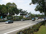
s that allow motorists to travel quickly from one urban area to another. All of them are dual carriageway
Dual carriageway
A dual carriageway is a class of highway with two carriageways for traffic travelling in opposite directions separated by a central reservation...
s with grade-separated
Grade separation
Grade separation is the method of aligning a junction of two or more transport axes at different heights so that they will not disrupt the traffic flow on other transit routes when they cross each other. The composition of such transport axes does not have to be uniform; it can consist of a...
access
Interchange (road)
In the field of road transport, an interchange is a road junction that typically uses grade separation, and one or more ramps, to permit traffic on at least one highway to pass through the junction without directly crossing any other traffic stream. It differs from a standard intersection, at which...
. They usually have three to four lane
Lane
A lane is a part of the roadway within a road marked out for use by a single line of vehicles in such a way as to control and guide drivers for the purpose of reducing traffic conflicts. Most public roads have at least two lanes, one for traffic in each direction, separated by Lane markings...
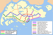
s in each direction, although there are two-lane or five-lane carriageways in some places. There are nine expressways, including the new Kallang–Paya Lebar Expressway, which was completed in September 2008, and another one to start construction in 2008, the Marina Coastal Expressway
Marina Coastal Expressway
The Marina Coastal Expressway is the second newest of Singapore's network of expressways, and is slated for construction commencement in 2008 and completion at the end of 2013.-Route:...
. Studies about the feasibility of additional expressways are ongoing.
Construction on the first expressway, the Pan Island Expressway
Pan Island Expressway
The Pan Island Expressway is the oldest and longest of Singapore's expressways. Currently, it is also Singapore's longest road. It extends along the length of the island, connecting Tuas in the west to Singapore Changi Airport in the east. Its length is .-Construction:Construction of the PIE...
, started in 1966. The other expressways were completed in stages, with the Kallang–Paya Lebar Expressway being the most recently completed, in 2008. Today, there are 160 km of expressways in Singapore.
The Singaporean expressway networks are connected with Malaysian expressway networks
Malaysian Expressway System
The Malaysian Expressway System , which begins with the North-South Expressway , is currently in the process of being substantially developed...
via Ayer Rajah Expressway
Ayer Rajah Expressway
The Ayer Rajah Expressway extends from the western end of the East Coast Parkway in the south of Singapore to Tuas in the west near the Tuas Second Link to Malaysia...
(connects with the Second Link Expressway
Second Link Expressway
Second Link Expressway , is the expressway which links Senai North at North-South Expressway, Senai Airport and Taman Perling, Johor Bahru via its extension known as Pontian-Johor Bahru Parkway to the Malaysia-Singapore Second Link.Usually, travelling along the second link is much faster than...
in Malaysia) and Bukit Timah Expressway
Bukit Timah Expressway
The Bukit Timah Expressway ; ) is a highway in Singapore that starts at the PIE in Bukit Timah and travels north to the Woodlands Checkpoint and the Johor–Singapore Causeway....
(connects with the Skudai Highway
Skudai Highway
Skudai Highway , also known as Senai Highway Jalan Tun Abdul Razak or Jalan Skudai, Federal route is a 29 kilometre partial-access highway in Johor, Malaysia, from the town of Senai to the Johor-Singapore Causeway, which connects Malaysia and...
via Johor–Singapore Causeway).
Expansion
The latest expressway completed is the Kallang–Paya Lebar Expressway which runs for 12 km, 9 km of which are 10 m underground. Construction started in 2001 and a 3 km section linking the Pan Island ExpresswayPan Island Expressway
The Pan Island Expressway is the oldest and longest of Singapore's expressways. Currently, it is also Singapore's longest road. It extends along the length of the island, connecting Tuas in the west to Singapore Changi Airport in the east. Its length is .-Construction:Construction of the PIE...
and East Coast Parkway
East Coast Parkway
The East Coast Parkway is an expressway that runs along the southeastern coast of Singapore. The expressway is approximately in length, and connects Singapore Changi Airport in the east to the Benjamin Sheares Bridge in the south of the main island before it links with the Ayer Rajah Expressway...
was opened in late 2007. It was completed on 20 September 2008.
On 27 July 2007, the Land Transport Authority
Land Transport Authority
The Land Transport Authority is a statutory board under the Ministry of Transport of the Singapore Government.-History:...
announced that approval had been given for the construction of a new 5 km long Marina Coastal Expressway
Marina Coastal Expressway
The Marina Coastal Expressway is the second newest of Singapore's network of expressways, and is slated for construction commencement in 2008 and completion at the end of 2013.-Route:...
(MCE) at a cost of $2.5 billion. The underground expressway will link the East Coast Parkway
East Coast Parkway
The East Coast Parkway is an expressway that runs along the southeastern coast of Singapore. The expressway is approximately in length, and connects Singapore Changi Airport in the east to the Benjamin Sheares Bridge in the south of the main island before it links with the Ayer Rajah Expressway...
and Kallang-Paya Lebar Expressway to Marina South
Marina South
Marina South is a peninsula adjacent to the Central Business District in Singapore, and also the name of an urban planning area in the Central Area of Singapore's Central Region.-History:...
and Ayer Rajah Expressway
Ayer Rajah Expressway
The Ayer Rajah Expressway extends from the western end of the East Coast Parkway in the south of Singapore to Tuas in the west near the Tuas Second Link to Malaysia...
and will be completed by end 2013.
Construction of the 11th expressway, the North–South Expressway, was announced on 30 January 2008. The new 21-kilometre expressway will cost about $7 to $8 billion when fully completed by 2020 and connect the East Coast Parkway
East Coast Parkway
The East Coast Parkway is an expressway that runs along the southeastern coast of Singapore. The expressway is approximately in length, and connects Singapore Changi Airport in the east to the Benjamin Sheares Bridge in the south of the main island before it links with the Ayer Rajah Expressway...
with the northern parts of Singapore.
Features
There are no traffic lights on the expressways. At an interchangeInterchange (road)
In the field of road transport, an interchange is a road junction that typically uses grade separation, and one or more ramps, to permit traffic on at least one highway to pass through the junction without directly crossing any other traffic stream. It differs from a standard intersection, at which...
with another road, an expressway is connected to it via slip roads. This allows traffic to change routes without having to stop or slow down. Due to the need to conserve space in land-scarce Singapore, there are no cloverleaf interchange
Cloverleaf interchange
A cloverleaf interchange is a two-level interchange in which left turns, reverse direction in left-driving regions, are handled by ramp roads...
s on the entire island. Instead, traffic efficiency and land space are maximized by having traffic lights on terrestrial roads, as well as the usage of interchanges such as stack interchange
Stack interchange
A stack interchange is a free-flowing grade separated junction between two roads.In countries where one drives on the right, left turns are handled by semi-directional flyover/under ramps...
s. The most common forms of highway-road or highway-highway intersections are single-point urban
Single-point urban interchange
A single-point urban interchange , also called a single-point interchange or single-point diamond interchange , is a type of highway interchange...
, diamond
Diamond interchange
A diamond interchange is a common type of road junction, used where a freeway crosses a minor road. The freeway itself is grade-separated from the minor road, one crossing the other over a bridge...
, and trumpet interchanges.
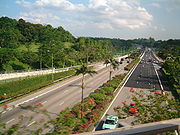
The road surface is asphalt
Asphalt
Asphalt or , also known as bitumen, is a sticky, black and highly viscous liquid or semi-solid that is present in most crude petroleums and in some natural deposits, it is a substance classed as a pitch...
, unlike normal roads which may have concrete
Concrete
Concrete is a composite construction material, composed of cement and other cementitious materials such as fly ash and slag cement, aggregate , water and chemical admixtures.The word concrete comes from the Latin word...
surfaces. The lanes are separated with white dashed lines, while unbroken white lines are used to mark the edges of the median and shoulder
Shoulder (road)
A hard shoulder, or simply shoulder, is a reserved area by the verge of a road or motorway. Generally it is kept clear of motor vehicle traffic...
. The shoulder is reserved for stops due to breakdowns and emergencies, and motorists are prohibited by law from travelling on it. Lanes are numbered from right to left, with lane 1 being the closest to the median. Crash barriers, cat's eyes
Cat's eye (road)
The cat's eye is a retroreflective safety device used in road marking and was the first of a range of raised pavement markers. It originated in the UK in 1933 and is today used all over the world....
and rumble strip
Rumble strip
Rumble strips, also known as sleeper lines, are a road safety feature that alert inattentive drivers to potential danger by causing a tactile vibration and audible rumbling, transmitted through the wheels into the car body...
s are also used to ensure road safety.
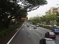
There are signs marking the start and end of an expressway at its entry and exit points respectively. The Electronic Monitoring and Advisory System
Electronic Monitoring and Advisory System
The Expressway Monitoring and Advisory System , also known by its acronym of EMAS, is a computerised system that is used to monitor traffic on Singapore's expressways. EMAS enables Land Transport Authority personnel to detect accidents and respond to them more quickly...
is used on all the expressways — cameras are used for live monitoring of expressway conditions, and LED
LEd
LEd is a TeX/LaTeX editing software working under Microsoft Windows. It is a freeware product....
signboards display information messages, such as warning
Warning
Warning may refer to:- Signal :* Precautionary statement* Warning sign* Warning system* Warning , issued by a police officer in lieu of a citation following a traffic stop- Music :* Warning...
s of any disruptions to the normal flow of traffic, as well as estimated travel times. The Bukit Timah Expressway is part of Asian Highway Network
Asian Highway Network
The Asian Highway project, also known as the Great Asian Highway, is a cooperative project among countries in Asia and Europe and the United Nations Economic and Social Commission for Asia and the Pacific , to improve the highway systems in Asia...
. The longest expressway, the Pan Island Expressway, is only 41 km (25.5 mi) long and therefore there are no rest area
Rest area
A rest area, travel plaza, rest stop, or service area is a public facility, located next to a large thoroughfare such as a highway, expressway, or freeway at which drivers and passengers can rest, eat, or refuel without exiting on to secondary roads...
s.
Safety
The default speed limit and National Speed Limits on Singapore expressways is 90 km/h (55.9 mph), but in certain areas a lower speed limit such as 80 km/h (49.7 mph) or 70 km/h (43.5 mph) is applied, especially in large urban areas, tunnels, heavy traffic and crosswinds. Speed traps are also deployed by the Singapore police at many places along the expressways.Certain types of transport, such as pedestrian
Pedestrian
A pedestrian is a person traveling on foot, whether walking or running. In some communities, those traveling using roller skates or skateboards are also considered to be pedestrians. In modern times, the term mostly refers to someone walking on a road or footpath, but this was not the case...
s, bicycle
Bicycle
A bicycle, also known as a bike, pushbike or cycle, is a human-powered, pedal-driven, single-track vehicle, having two wheels attached to a frame, one behind the other. A person who rides a bicycle is called a cyclist, or bicyclist....
s, and learner driver
Driver's license
A driver's license/licence , or driving licence is an official document which states that a person may operate a motorized vehicle, such as a motorcycle, car, truck or a bus, on a public roadway. Most U.S...
s, are not allowed.
Semi-expressways
In SingaporeSingapore
Singapore , officially the Republic of Singapore, is a Southeast Asian city-state off the southern tip of the Malay Peninsula, north of the equator. An island country made up of 63 islands, it is separated from Malaysia by the Straits of Johor to its north and from Indonesia's Riau Islands by the...
, there are three semi-expressways: Nicoll Highway
Nicoll Highway
Nicoll Highway is a major arterial road in Singapore which links Kallang to the city. En route, it passes through the areas of Kallang, Kampong Glam and Marina Centre....
, the Outer Ring Road System
Outer Ring Road System
The Outer Ring Road System, or more commonly known as ORRS, is a network of major arterial roads in Singapore that forms a 'ring' along the towns outside the city. The ORRS is a semi-expressway, just like the West Coast Highway. Since 1994, roads along the ORRS have been upgraded in stages to...
(ORRS) and West Coast Highway
West Coast Highway, Singapore
West Coast Highway is a major arterial road in Singapore which links Jurong industrial estate and Clementi New Town to the city...
. These semi-expressways are scaled down versions of expressways. Semi-expressways do not have a uniform speed limit through its entire length, and some sections still feature traffic light controlled junctions, such as the eastern section of the ORRS and the controlled roundabout
Roundabout
A roundabout is the name for a road junction in which traffic moves in one direction around a central island. The word dates from the early 20th century. Roundabouts are common in many countries around the world...
along the West Coast Highway. Still, just like expressways, semi-expressways allow motorists to travel quickly from one urban area to another with the use of viaduct
Viaduct
A viaduct is a bridge composed of several small spans. The term viaduct is derived from the Latin via for road and ducere to lead something. However, the Ancient Romans did not use that term per se; it is a modern derivation from an analogy with aqueduct. Like the Roman aqueducts, many early...
s, overpass
Overpass
An overpass is a bridge, road, railway or similar structure that crosses over another road or railway...
es and underpasses.
Diagram
See also
- Land Transport AuthorityLand Transport AuthorityThe Land Transport Authority is a statutory board under the Ministry of Transport of the Singapore Government.-History:...
- Ministry of Transport (Singapore)Ministry of Transport (Singapore)The Ministry of Transport is a ministry in the Government of Singapore that administers and regulates land, sea and air transportation within the republic’s jurisdiction....