

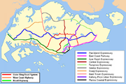
Outer Ring Road System
Encyclopedia
Road
A road is a thoroughfare, route, or way on land between two places, which typically has been paved or otherwise improved to allow travel by some conveyance, including a horse, cart, or motor vehicle. Roads consist of one, or sometimes two, roadways each with one or more lanes and also any...
s in Singapore
Singapore
Singapore , officially the Republic of Singapore, is a Southeast Asian city-state off the southern tip of the Malay Peninsula, north of the equator. An island country made up of 63 islands, it is separated from Malaysia by the Straits of Johor to its north and from Indonesia's Riau Islands by the...
that forms a 'ring' along the towns outside the city. The ORRS is a semi-expressway, just like the West Coast Highway
West Coast Highway, Singapore
West Coast Highway is a major arterial road in Singapore which links Jurong industrial estate and Clementi New Town to the city...
. Since 1994, roads along the ORRS have been upgraded in stages to provide a smoother route to travel across the island
Singapore
Singapore , officially the Republic of Singapore, is a Southeast Asian city-state off the southern tip of the Malay Peninsula, north of the equator. An island country made up of 63 islands, it is separated from Malaysia by the Straits of Johor to its north and from Indonesia's Riau Islands by the...
. Construction currently in progress includes Paya Lebar Viaduct
Bartley Road
Bartley Road is a major road in Singapore extending from Upper Serangoon Road to Tampines Avenue 10. The road has a distance of 5.8 km. En route, it passes through the areas of Serangoon, Bartley, Paya Lebar, Defu, Kaki Bukit and Bedok Reservoir...
and MacRitchie Viaduct
MacRitchie Viaduct
MacRitchie Viaduct is a viaduct in Thomson, Singapore that was built on top of Lornie Road and Thomson Road, with its extension also above Braddell Road...
.
Benefit
Once the ORRS is completed, traffic volume on city-bound roads will be reduced. It also provides an alternative route for motorists to travel between the east and west of Singapore without going through the city. Since ORRS is extensively linked to expressways and other arterial roads, such as Bukit Timah RoadBukit Timah Road
Bukit Timah Road is a major road in Singapore extending from the city centre to Woodlands Road on the way to Johor Bahru in Malaysia. The road has a distance of 25km , which is one of the longest roads in Singapore, and the road takes its name from the hill...
, motorists can get from one traffic route to another easily. It also serve as alternative bypass routes in the East
East Region, Singapore
The East Region of Singapore is one of the five regions in the city-state. It includes six urban planning areas. As its name implies, it is the easternmost region of Singapore.The land area is about 11,000 hectares.-Urban planning areas in East Region:...
-West
West Region, Singapore
The West Region of Singapore is one of the five regions in the city-state. Comprising 25,500 hectares of land area, it is the largest of all regions, it includes twelve urban planning areas and has at least a population of over 1 million. As its name implies, it is the westernmost region of Singapore...
corridor for motorists to travel without going through the city centre
Central Region, Singapore
The Central Region of Singapore is one of the five regions in the city-state. Comprising 13,150 hectares of land area, it includes 11 Planning Areas within the Central Area which is the immediate vicinity of the Singapore's central business district, as well as another 11 more outside it.Although...
.
Upgrading project
The first upgrading stage started in 1994. Two junctions along Farrer Road were the first to be upgraded. The upgrading project had to be carried out in stages in order to minimise disruption to traffic. The completion of the Portsdown Flyover, Queensway Flyover and Queensway Underpass marks another milestone in the realisation of the ORRS. The Farrer Road section of the upgrading project is expected to be completed by 2009.Route
The ORRS starts from Still Road South and it connects with East Coast ParkwayEast Coast Parkway
The East Coast Parkway is an expressway that runs along the southeastern coast of Singapore. The expressway is approximately in length, and connects Singapore Changi Airport in the east to the Benjamin Sheares Bridge in the south of the main island before it links with the Ayer Rajah Expressway...
. It then goes north to Still Road and Jalan Eunos, where it links with Pan Island Expressway
Pan Island Expressway
The Pan Island Expressway is the oldest and longest of Singapore's expressways. Currently, it is also Singapore's longest road. It extends along the length of the island, connecting Tuas in the west to Singapore Changi Airport in the east. Its length is .-Construction:Construction of the PIE...
. It then continues to go north to Eunos Link and Hougang Avenue 3. From here, a left turn is made at Hougang Avenue 3 and the route continues west to Bartley Road
Bartley Road
Bartley Road is a major road in Singapore extending from Upper Serangoon Road to Tampines Avenue 10. The road has a distance of 5.8 km. En route, it passes through the areas of Serangoon, Bartley, Paya Lebar, Defu, Kaki Bukit and Bedok Reservoir...
, Braddell Road and Lornie Road. A connection is made to the Central Expressway
Central Expressway
The following roads are named Central Expressway:*Central Expressway, Singapore*Central Expressway , part of County Route G6 in Santa Clara County, California*Central Expressway , part of U.S. Highway 75 in Dallas, Texas...
during this stretch. The route then continues south to Adam Road, Farrer Road, Queensway and Portsdown Avenue. During this stretch, a connection is made to the Pan Island Expressway. The ORRS ends at Ayer Rajah Expressway
Ayer Rajah Expressway
The Ayer Rajah Expressway extends from the western end of the East Coast Parkway in the south of Singapore to Tuas in the west near the Tuas Second Link to Malaysia...
, with the connection with Portsdown Avenue.
Interchange along ORRS
| Road name | Type | Remarks | Name of interchange | |
|---|---|---|---|---|
| Still Road South | East Coast Parkway | Trumpet, Parclo | Start of ORRS leading westbound; end of ORRS leading eastbound | Marine Parade Flyover |
| Marine Parade Road | Box Box junction A box junction is a traffic control measure designed to prevent gridlock at busy road junctions. The surface of the junction is marked with a criss-cross grid of diagonal painted lines , and vehicles may not enter the area so marked unless their exit from the junction is clear A box junction is a... |
- | - | |
| Still Road | East Coast Road | Box | - | - |
| Koon Seng Road & Lorong J Telok Kurau | Box | - | - | |
| Joo Chiat Place | Box | - | - | |
| Jalan Eunos | Changi Road | Box | Changi Road travels westbound | - |
| Sims Avenue Sims Avenue Sims Avenue is a road in Singapore from Kallang Road to Jalan Eunos. It has bus lane in the whole stretch, with one of them between Kallang Road and Sims Way is a full-day bus lane. It extends as Sims Avenue East, and continues to the Siglap Road. The extension after Siglap Road is named New Upper... & Sims Avenue East Sims Avenue Sims Avenue is a road in Singapore from Kallang Road to Jalan Eunos. It has bus lane in the whole stretch, with one of them between Kallang Road and Sims Way is a full-day bus lane. It extends as Sims Avenue East, and continues to the Siglap Road. The extension after Siglap Road is named New Upper... |
Box | Sims Avenue & Sims Avenue East travels eastbound only | - | |
| Eunos Cresent | 3-way | - | - | |
| Pan Island Expressway | SPUI Single-point urban interchange A single-point urban interchange , also called a single-point interchange or single-point diamond interchange , is a type of highway interchange... |
- | Eunos Flyover | |
| Eunos Link | Bedok Reservoir Road | 3-way | - | - |
| Ubi Avenue 2 & Kaki Bukit Avenue 1 | Box | - | - | |
| Hougang Avenue 3 | Airport Road | Box | - | - |
| Bartley Road | SPUI | From Hougang Avenue 3, the ORRS turns left towards Bartley Road and the ORRS continues from there. | Paya Lebar Viaduct Bartley Road Bartley Road is a major road in Singapore extending from Upper Serangoon Road to Tampines Avenue 10. The road has a distance of 5.8 km. En route, it passes through the areas of Serangoon, Bartley, Paya Lebar, Defu, Kaki Bukit and Bedok Reservoir... |
|
| Bartley Road | Upper Paya Lebar Road | Box | - | - |
| Serangoon Avenue 1 | 3-way | - | - | |
| Braddell Road | Upper Serangoon Road | 3-Level Diamond | To go from Bartley Road to Braddell Road without stopping, one can drive through Bartley Underpass Bartley Road Bartley Road is a major road in Singapore extending from Upper Serangoon Road to Tampines Avenue 10. The road has a distance of 5.8 km. En route, it passes through the areas of Serangoon, Bartley, Paya Lebar, Defu, Kaki Bukit and Bedok Reservoir... . This interchange is Singapore's first four-tier interchange, with, from highest to lowest, Upper Serangoon Viaduct Upper Serangoon Viaduct Upper Serangoon Viaduct is a viaduct in Serangoon that was built on top of Upper Serangoon Road. The viaduct is built to allow residents living in the north-eastern part of Singapore, especially residents living in Hougang, Buangkok, Sengkang and Punggol, a high-speed access to the city centre... , Upper Serangoon Road, Bartley Underpass and NEL tunnel North East MRT Line The North East MRT Line is the third Mass Rapid Transit line in Singapore and the world's second longest fully underground, automated and driverless, rapid transit line after Singapore's Circle MRT Line. The line is 20 km long with 16 stations and operated by SBS Transit. Travelling from one end... . |
Bartley Underpass, Upper Serangoon Viaduct |
| Central Expressway, Lorong Chuan Lorong Chuan Lorong Chuan is a road linking the Central Expressway to Serangoon Garden Way in Serangoon Gardens. It is in the north-eastern region of Singapore. The area around the street is named after this road... |
3-Level SPUI Single-point urban interchange A single-point urban interchange , also called a single-point interchange or single-point diamond interchange , is a type of highway interchange... |
Braddell Underpass (along Braddell Road) offers a non-stop drive through this interchange, Braddell Flyover (along CTE Central Expressway The following roads are named Central Expressway:*Central Expressway, Singapore*Central Expressway , part of County Route G6 in Santa Clara County, California*Central Expressway , part of U.S. Highway 75 in Dallas, Texas... ) |
Braddell Underpass, Braddell Flyover | |
| Lorong 8 Toa Payoh | Slip lane Slip lane A slip lane is a road traffic lane provided at an intersection to allow vehicles to turn at the intersection without actually entering it and interfering with through traffic.... |
Lorong 8 Toa Payoh only allows traffic to travel westbound only. Vehicles are not permitted to leave the ORRS here. | - | |
| Bishan Street 11 | LILO Right-in/right-out Right-in/right-out and left-in/left-out refer to a type of road intersection where turning movements of vehicles are restricted. A RIRO permits only right turns and a LILO permits only left turns. RIRO is usual where vehicles drive on the right, and LILO is usual where vehicles drive on the left... |
Can only be accessed by traffic travelling eastbound. | - | |
| Lorong 6 Toa Payoh | Trumpet | - | Toa Payoh North Flyover | |
| Bishan Road | Semi-directional T | Bishan Flyover (along Braddell Road) offers a non-stop drive through this interchange. | Bishan Flyover | |
| Thomson Road | To go from Braddell Road to Lornie Road (passing Marymount Road's flyover and Thomson Road) without stopping, one can drive on MacRitchie Viaduct MacRitchie Viaduct MacRitchie Viaduct is a viaduct in Thomson, Singapore that was built on top of Lornie Road and Thomson Road, with its extension also above Braddell Road... . |
Marymount Flyover, MacRitchie Viaduct | ||
| Lornie Road | To go from Lornie Road to Adam Road without stopping, one can drive on Adam Flyover. | Adam Flyover | ||
| Adam Road | Pan Island Expressway | Parclo | - | Adam Flyover |
| Dunearn Road | 3-Level Diamond | Dunearn Road travels east bound only, Farrer Flyover (from Adam Road to Farrer Road), Dunearn Underpass (along Dunearn Road). | Farrer Flyover, Dunearn Underpass | |
| Farrer Road | Bukit Timah Road Bukit Timah Road Bukit Timah Road is a major road in Singapore extending from the city centre to Woodlands Road on the way to Johor Bahru in Malaysia. The road has a distance of 25km , which is one of the longest roads in Singapore, and the road takes its name from the hill... |
3-Level Diamond | Bukit Timah Road travels west wards only, Farrer Flyover, Bukit Timah Underpass (along Bukit Timah Road). | Farrer Flyover, Bukit Timah Underpass |
| Holland Road Holland Road, Singapore Holland Road is a long road in Singapore, running roughly east-west linking Clementi in the west to the Singapore Botanic Gardens where it joins Napier Road and then Orchard Road.... |
3-Level Diamond | To go from Farrer Road to Queensway without stopping, one can drive through Farrer Underpass, Holland Flyover (along Holland Road) | Farrer Underpass, Holland Flyover | |
| Queensway | Commonwealth Drive | LILO | Can only be accessed by traffic travelling eastbound. | - |
| Margaret Drive | LILO | Can only be accessed by traffic travelling westbound. | - | |
| Commonwealth Avenue Commonwealth Avenue Commonwealth Avenue is an avenue which may refer to:in Australia*Commonwealth Avenue, Canberrain the Philippines*Commonwealth Avenue, Quezon Cityin Singapore*Commonwealth Avenue, Singaporein the United States... |
SPUI | Queensway Underpass (along Queensway) offers a non-stop drive through this interchange. | Queensway Underpass | |
| Portsdown Avenue | Queensway | 3-way | From Queensway, it goes straight towards Portsdown Avenue and the ORRS continues from there. | Queensway Flyover |
| Ayer Rajah Expressway | SPUI | Start of ORRS going eastbound; end of ORRS going westbound | Portsdown Flyover | |
: Only Expressways
Controlled-access highway
A controlled-access highway is a highway designed exclusively for high-speed vehicular traffic, with all traffic flow and ingress/egress regulated...
, Arterial road
Arterial road
An arterial road, or arterial thoroughfare, is a high-capacity urban road. The primary function of an arterial road is to deliver traffic from collector roads to freeways, and between urban centres at the highest level of service possible. As such, many arteries are limited-access roads, or feature...
s and major roads, such as Pan Island Expressway
Pan Island Expressway
The Pan Island Expressway is the oldest and longest of Singapore's expressways. Currently, it is also Singapore's longest road. It extends along the length of the island, connecting Tuas in the west to Singapore Changi Airport in the east. Its length is .-Construction:Construction of the PIE...
, Bartley Road
Bartley Road
Bartley Road is a major road in Singapore extending from Upper Serangoon Road to Tampines Avenue 10. The road has a distance of 5.8 km. En route, it passes through the areas of Serangoon, Bartley, Paya Lebar, Defu, Kaki Bukit and Bedok Reservoir...
and Lorong 6 Toa Payoh, will be mentioned. Minor roads, such as Mount Vernon Road, will not be mentioned.