

Nicoll Highway
Encyclopedia
Road
A road is a thoroughfare, route, or way on land between two places, which typically has been paved or otherwise improved to allow travel by some conveyance, including a horse, cart, or motor vehicle. Roads consist of one, or sometimes two, roadways each with one or more lanes and also any...
in Singapore which links Kallang to the city. En route, it passes through the areas of Kallang
Kallang
Kallang is an urban planning area and a subdivision located in the southeastern part of Singapore.It is probably best known for being the location of the Singapore Indoor Stadium & the old National Stadium, as well as the new Singapore Sports Hub...
, Kampong Glam
Kampong Glam
Kampong Glam is a neighbourhood in Singapore. It is located north of the Singapore River, in the urban planning areas of Kallang and Rochor.-History:...
and Marina Centre
Marina Centre
Marina Centre is a zone of reclaimed land within the Downtown Core in the southern part of Singapore. Together with the Marina South area, it encloses the sheltered Marina Bay....
.
Despite what its name may suggest, the speed limit on the highway is less than that of an expressway. The highway also has traffic light junctions at some of its intersection with roads such as Bras Basah Road
Bras Basah Road
Bras Basah Road is a one-way road in Singapore in the planning areas of Museum and Downtown Core. The road starts at the junction of Orchard Road and Handy Road, at the ERP gantry towards the Central Business District, and ends at the junction of Nicoll Highway and Raffles Boulevard which then...
and Esplanade Drive
Esplanade Bridge
The Esplanade Bridge is a 260 metre-long road bridge that spans across the mouth of the Singapore River in Singapore with the Esplanade - Theatres on the Bay on its northern abutment and the Merlion on the southern...
, which are not found in expressways.
History
When the Merdeka BridgeMerdeka Bridge
The Merdeka Bridge is a vehicular and pedestrian bridge located in Kallang in the south-eastern part of Singapore. It spans over the river mouths of the Kallang River and Rochor River, which empty into the Kallang Basin...
was completed over the Kallang River in 1956, Nicoll Highway formed the vital link between the city centre
Downtown Core
The Downtown Core is a 266-hectare urban planning area in the south of the city-state of Singapore. The Downtown Core surrounds the mouth of the Singapore River and southeastern portion of its watershed, and is part of the Central Area, Singapore's central business district...
and the rapidly growing east coast
East Region, Singapore
The East Region of Singapore is one of the five regions in the city-state. It includes six urban planning areas. As its name implies, it is the easternmost region of Singapore.The land area is about 11,000 hectares.-Urban planning areas in East Region:...
. Nicoll Highway's role is now taken over by the Benjamin Sheares Bridge
Benjamin Sheares Bridge
Opened in 1981, the Benjamin Sheares Bridge is the longest bridge in Singapore, spanning 1.8 km, and the tallest, at 20 m. It is named after Dr Benjamin Henry Sheares, the 2nd president of the Republic. The bridge is part of the East Coast Parkway...
on the East Coast Parkway
East Coast Parkway
The East Coast Parkway is an expressway that runs along the southeastern coast of Singapore. The expressway is approximately in length, and connects Singapore Changi Airport in the east to the Benjamin Sheares Bridge in the south of the main island before it links with the Ayer Rajah Expressway...
.The highway was named after Sir John Fearns Nicoll
John Fearns Nicoll
Sir John Fearns Nicoll was a British colonial governor. He was Colonial Secretary of Hong Kong from 1949 to 1952, and Governor of Singapore from 1952 to 1955.He died at the hospital located at Scio House, Putney Heath....
, Governor of the Colony from 1952 to 1955.
Nicoll Highway collapse
At approximately 3:30 p.m. Singapore Time (UTC+8:00) on April 20, 2004, a section of Nicoll Highway between Ophir RoadOphir Road
Ophir Road is a road that starts after the junction of Sungei Road and Jalan Besar and ends after the Ophir Flyover leading towards East Coast Parkway to Ayer Rajah Expressway or Singapore Changi Airport. The road is located within the planning areas of Kallang, Downtown Core and Rochor...
and Merdeka Bridge
Merdeka Bridge
The Merdeka Bridge is a vehicular and pedestrian bridge located in Kallang in the south-eastern part of Singapore. It spans over the river mouths of the Kallang River and Rochor River, which empty into the Kallang Basin...
collapsed, due to the failure of the retaining wall of the Circle Line
Circle MRT Line
The Circle Line is Singapore's fourth Mass Rapid Transit line, operated by SMRT Corporation. This underground line is currently long with 28 stations and is fully automatically operated...
tunnel below it. This section of the road to be closed for several months for repairs. All bus services going through that sector of Nicoll Highway had to be redirected. The road was re-opened in December later that year.
Landmarks
Some landmarks that can be seen along the road are:- Civilian War MemorialCivilian War MemorialThe Memorial to the Civilian Victims of the Japanese Occupation, usually called the Civilian War Memorial is one of Singapore's most famous iconic landmarks of heritage....
- Golden Mile ComplexGolden Mile ComplexGolden Mile Complex is a high-rise commercial and residential building on Beach Road in Kallang, Singapore. The building was formerly known as Woh Hup Complex...
- Golden Mile Tower
- Merdeka BridgeMerdeka BridgeThe Merdeka Bridge is a vehicular and pedestrian bridge located in Kallang in the south-eastern part of Singapore. It spans over the river mouths of the Kallang River and Rochor River, which empty into the Kallang Basin...
- National StadiumNational Stadium, SingaporeThe Singapore National Stadium was located in Kallang. Opened in July 1973, the National Stadium was officially closed on 30 June 2007 and has demolished to make way for the Singapore Sports Hub and New Singapore National Stadium which is expected to open in 2014.The stadium has played host to...
- One Raffles LinkOne Raffles LinkOne Raffles Link is an office building located at Marina Centre, Singapore. The building is six storeys high with a basement and is managed by Hongkong Land. Completed in 2000, it was jointly designed by world renowned architect, Kohn Pedersen Fox and Aedas LPT Architects. The development costs...
- People's AssociationPeople's AssociationThe People’s Association was established in Singapore as a statutory board on 1 July 1960 to promote racial harmony and social cohesion. PA commemorated its 50th Anniversary in 2010....
- Shaw Tower
- Suntec CitySuntec CitySuntec City is a major multi-use development located in Marina Centre, a subzone of the Downtown Core Planning Area in Singapore.- Design :Suntec City was designed by Tsao & McKown Architects with emphasis on Chinese geomancy . The five buildings and the convention center are arranged so that they...
- The ConcourseThe ConcourseThe Concourse is a post-modern high-rise commercial and residential building on Beach Road in Kallang, Singapore.-History:The Concourse is located in Singapore's "Golden Mile", which refers to the strip of land between Nicoll Highway and Beach Road. It was planned by the Singapore Government as a...
- The GatewayThe Gateway, SingaporeThe Gateway is a 37-storey, , twin tower skyscraper complex completed in April 1990 on Beach Road in the Downtown Core of Singapore. The two buildings are named The Gateway East and The Gateway West.-Architecture:...
- War Memorial ParkWar Memorial Park, SingaporeWar Memorial Park is a parkland in Singapore, located along Beach Road in the Downtown Core of Singapore's Central Region. The Civilian War Memorial is located at the center of the park as a memorial to civilians who died in Singapore during World War II...
Interchange along Nicoll Highway
| Interchange with | Type | Remarks | Name of interchange |
| KPE, Sims Way, Guillemard Road and Mountbatten Road | Box Box junction A box junction is a traffic control measure designed to prevent gridlock at busy road junctions. The surface of the junction is marked with a criss-cross grid of diagonal painted lines , and vehicles may not enter the area so marked unless their exit from the junction is clear A box junction is a... |
Start of Nicoll Highway leading westbound; end of Nicoll Highway leading eastbound | - |
| Stadium Road and links from Stadium Drive | 3-way 3-way junction A 3-way junction is a type of road junction with three arms. A Y junction generally has 3 arms of equal size... |
- | - |
| Stadium Road | Flyover Overpass An overpass is a bridge, road, railway or similar structure that crosses over another road or railway... |
- | Merdaka Bridge |
| Crawford Road and Republic Avenue | Flyover | - | Merdaka Bridge |
| Java Road | 3-way 3-way junction A 3-way junction is a type of road junction with three arms. A Y junction generally has 3 arms of equal size... |
There is also a 3-way link from Republic Avenue | - |
| Ophir Road Ophir Road Ophir Road is a road that starts after the junction of Sungei Road and Jalan Besar and ends after the Ophir Flyover leading towards East Coast Parkway to Ayer Rajah Expressway or Singapore Changi Airport. The road is located within the planning areas of Kallang, Downtown Core and Rochor... |
Flyover | Ophir Road travels southbound only | Ophir Flyover |
| Rochor Road | Flyover | Rochor Road travels northbound only | Rochor Flyover |
| Middle Road Middle Road Middle Road is a road that may refer to*Middle Road, Hong Kong, in Tsim Sha Tsui, Kowloon, Hong Kong*Middle Road, Singapore*The Middle Road, Canada, which was renamed as part of the Queen Elizabeth Way in 1939... |
3-way | - | - |
| Raffles Boulevard and Bras Basah Road Bras Basah Road Bras Basah Road is a one-way road in Singapore in the planning areas of Museum and Downtown Core. The road starts at the junction of Orchard Road and Handy Road, at the ERP gantry towards the Central Business District, and ends at the junction of Nicoll Highway and Raffles Boulevard which then... |
Box | Raffles Boulevard and Bras Basah Road travels eastbound only | - |
| Raffles Avenue, Esplanade Drive and Stamford Road Stamford Road Stamford Road is a one-way road in Singapore within the planning areas of Downtown Core and Museum. The road continues after the traffic light junction of Nicoll Highway, Esplanade Drive and Raffles Avenue towards Orchard Road. It then ends at the junction of Fort Canning Road, Bencoolen Street... |
Box | Raffles Avenue and Stamford Road travels westbound only; Start of ORRS going northbound; end of ORRS going southbound | - |
: Road names are ordered in the clockwise fashion starting from the top.
See also
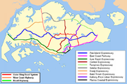
- Expressways of SingaporeExpressways of SingaporeThe expressways of Singapore are special roads that allow motorists to travel quickly from one urban area to another. All of them are dual carriageways with grade-separated access. They usually have three to four lanes in each direction, although there are two-lane or five-lane carriageways in some...
- Outer Ring Road SystemOuter Ring Road SystemThe Outer Ring Road System, or more commonly known as ORRS, is a network of major arterial roads in Singapore that forms a 'ring' along the towns outside the city. The ORRS is a semi-expressway, just like the West Coast Highway. Since 1994, roads along the ORRS have been upgraded in stages to...
- West Coast Highway, SingaporeWest Coast Highway, SingaporeWest Coast Highway is a major arterial road in Singapore which links Jurong industrial estate and Clementi New Town to the city...