
Engadin
Encyclopedia
German language
German is a West Germanic language, related to and classified alongside English and Dutch. With an estimated 90 – 98 million native speakers, German is one of the world's major languages and is the most widely-spoken first language in the European Union....
: Engadin, Italian
Italian language
Italian is a Romance language spoken mainly in Europe: Italy, Switzerland, San Marino, Vatican City, by minorities in Malta, Monaco, Croatia, Slovenia, France, Libya, Eritrea, and Somalia, and by immigrant communities in the Americas and Australia...
: Engadina, Romansh: Engiadina; tr: garden of the Inn) is a long valley in the Swiss Alps
Swiss Alps
The Swiss Alps are the portion of the Alps mountain range that lies within Switzerland. Because of their central position within the entire Alpine range, they are also known as the Central Alps....
located in the canton of Graubünden
Graubünden
Graubünden or Grisons is the largest and easternmost canton of Switzerland. The canton shares borders with the cantons of Ticino, Uri, Glarus and St. Gallen and international borders with Italy, Austria and Liechtenstein...
in southeast Switzerland
Switzerland
Switzerland name of one of the Swiss cantons. ; ; ; or ), in its full name the Swiss Confederation , is a federal republic consisting of 26 cantons, with Bern as the seat of the federal authorities. The country is situated in Western Europe,Or Central Europe depending on the definition....
. It follows the route of the Inn River
Inn River
The Inn is a river in Switzerland, Austria and Germany. It is a right tributary of the Danube and is approximately 500km long. The highest point of its drainage basin is the summit of Piz Bernina, at 4,049 metres.- Geography :...
from its headwaters at Maloja Pass
Maloja Pass
Maloja Pass is a high mountain pass in the Swiss Alps in the canton of Graubünden, linking the Engadin with the Val Bregaglia and Chiavenna in Italy...
running northeast until the Inn
Inn River
The Inn is a river in Switzerland, Austria and Germany. It is a right tributary of the Danube and is approximately 500km long. The highest point of its drainage basin is the summit of Piz Bernina, at 4,049 metres.- Geography :...
flows into Austria
Austria
Austria , officially the Republic of Austria , is a landlocked country of roughly 8.4 million people in Central Europe. It is bordered by the Czech Republic and Germany to the north, Slovakia and Hungary to the east, Slovenia and Italy to the south, and Switzerland and Liechtenstein to the...
one hundred kilometers downstream. The Engadin is protected by high mountains on all sides and is famous for its sunny climate, beautiful landscapes and outdoor activities.
Etymology
In Romansch, which is the indigenousIndigenous peoples
Indigenous peoples are ethnic groups that are defined as indigenous according to one of the various definitions of the term, there is no universally accepted definition but most of which carry connotations of being the "original inhabitants" of a territory....
language of the region, the "Engadin" literally translates as the Inn Garden; the garden of the Inn River (Romansch: En). However, historically, politically and geographically, the Engadin refers to the entire region, including the Inn River Valley, its tributaries and the surrounding mountains.
Geography
Alps
The Alps is one of the great mountain range systems of Europe, stretching from Austria and Slovenia in the east through Italy, Switzerland, Liechtenstein and Germany to France in the west....
range and constitutes the upper part of the 300 km-long Inn
Inn River
The Inn is a river in Switzerland, Austria and Germany. It is a right tributary of the Danube and is approximately 500km long. The highest point of its drainage basin is the summit of Piz Bernina, at 4,049 metres.- Geography :...
valley. From the Maloja Pass
Maloja Pass
Maloja Pass is a high mountain pass in the Swiss Alps in the canton of Graubünden, linking the Engadin with the Val Bregaglia and Chiavenna in Italy...
(1,815 m) to the border to Tyrol
Tyrol (state)
Tyrol is a state or Bundesland, located in the west of Austria. It comprises the Austrian part of the historical region of Tyrol.The state is split into two parts–called North Tyrol and East Tyrol–by a -wide strip of land where the state of Salzburg borders directly on the Italian province of...
(1,000 m) north of Vinadi the valley runs for a length of 100 km, always above 1,000 metres in elevation
Elevation
The elevation of a geographic location is its height above a fixed reference point, most commonly a reference geoid, a mathematical model of the Earth's sea level as an equipotential gravitational surface ....
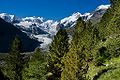
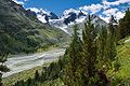
. The highest mountains of the valley are in the Bernina Range
Bernina Range
The Bernina Range is a mountain range in the Alps of eastern Switzerland and northern Italy. It is considered to be part of the Central Eastern Alps. It is one of the highest ranges of the Alps, covered with many glaciers. Piz Bernina , its highest peak, is the most easterly four thousand-metre...
in the upper part.
The Engadin is divided into two parts:
- The Upper Engadin from MalojaMaloja PassMaloja Pass is a high mountain pass in the Swiss Alps in the canton of Graubünden, linking the Engadin with the Val Bregaglia and Chiavenna in Italy...
to ZernezZernezZernez is a municipality in the district of Inn in the Swiss canton of Graubünden.Zernez is a major node in the regional road network, with roads leading into the Upper Engadin and towards Italy, the Lower Engadin and towards Austria, over the Fuorn Pass into the Val Mustair and over the Flüela Pass...
, where the valley is remarkably straight and wide, and up to S-chanfS-chanfS-chanf is a municipality in the district of Maloja in the Swiss canton of Graubünden.Localities in S-chanf municipality include Susauna, Chapella and Cinuos-chel.-Name:...
, fairly flat - The Lower EngadineLower EngadineThe Lower Engadine is part of the Engadin valley, traversed by the Inn river and located in Eastern Switzerland in the Canton Graubünden.In contrast to the elevated plain of the Upper Engadin, where the upper reaches of the Inn River flow gently down the valley, the geological background of the...
from ZernezZernezZernez is a municipality in the district of Inn in the Swiss canton of Graubünden.Zernez is a major node in the regional road network, with roads leading into the Upper Engadin and towards Italy, the Lower Engadin and towards Austria, over the Fuorn Pass into the Val Mustair and over the Flüela Pass...
to the AustriaAustriaAustria , officially the Republic of Austria , is a landlocked country of roughly 8.4 million people in Central Europe. It is bordered by the Czech Republic and Germany to the north, Slovakia and Hungary to the east, Slovenia and Italy to the south, and Switzerland and Liechtenstein to the...
n border, where the Inn drops more quickly and its path is more tortuous
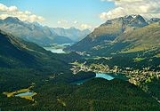
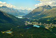
Upper Engadin
The Upper Engadin begins at the Maloja mountain passMountain pass
A mountain pass is a route through a mountain range or over a ridge. If following the lowest possible route, a pass is locally the highest point on that route...
with a chain of lakes running north-east–south-west: Lej da Segl (Lake Sils), famous for windsurfing, Lej da Silvaplauna (Lake Silvaplana), and Lej da San Murezzan (Lake St. Moritz). At the south-west end of the valley, the Maloja Pass drops precipitously down to Chiavenna in Italy
Italy
Italy , officially the Italian Republic languages]] under the European Charter for Regional or Minority Languages. In each of these, Italy's official name is as follows:;;;;;;;;), is a unitary parliamentary republic in South-Central Europe. To the north it borders France, Switzerland, Austria and...
through the Val Bregaglia
Bregaglia Range
The Bregaglia Range is a small group of mostly granite mountains in Graubünden, Switzerland and the Province of Sondrio, northern Italy. It derives its name from the partly Swiss, partly Italian valley, the Val Bregaglia, and is known as Bergell in German...
, and thence to Como
Como
Como is a city and comune in Lombardy, Italy.It is the administrative capital of the Province of Como....
. At the Lunghin Pass, above Maloja, lies the most notable triple watershed in western Europe, from where the Inn flows via the Danube
Danube
The Danube is a river in the Central Europe and the Europe's second longest river after the Volga. It is classified as an international waterway....
to the Black Sea
Black Sea
The Black Sea is bounded by Europe, Anatolia and the Caucasus and is ultimately connected to the Atlantic Ocean via the Mediterranean and the Aegean seas and various straits. The Bosphorus strait connects it to the Sea of Marmara, and the strait of the Dardanelles connects that sea to the Aegean...
, the Maira
Mera River
The Mera is a river in Switzerland and Italy. Its source is near the Maloja Pass, in Graubünden, Switzerland. It flows west through the Val Bregaglia and crosses the Italian border near Soglio...
via the Po
Po River
The Po |Ligurian]]: Bodincus or Bodencus) is a river that flows either or – considering the length of the Maira, a right bank tributary – eastward across northern Italy, from a spring seeping from a stony hillside at Pian del Re, a flat place at the head of the Val Po under the northwest face...
to the Mediterranean Sea
Mediterranean Sea
The Mediterranean Sea is a sea connected to the Atlantic Ocean surrounded by the Mediterranean region and almost completely enclosed by land: on the north by Anatolia and Europe, on the south by North Africa, and on the east by the Levant...
, and the Julia
Julia River
Julia is a river in the Grisons canton, eastern Switzerland. It is a tributary of the Albula river, which it meets in Tiefencastel. The road to the Julier Pass runs through the Julia valley....
via the Rhine to the North Sea
North Sea
In the southwest, beyond the Straits of Dover, the North Sea becomes the English Channel connecting to the Atlantic Ocean. In the east, it connects to the Baltic Sea via the Skagerrak and Kattegat, narrow straits that separate Denmark from Norway and Sweden respectively...
.
The resort of St. Moritz
St. Moritz
St. Moritz is a resort town in the Engadine valley in Switzerland. It is a municipality in the district of Maloja in the Swiss canton of Graubünden...
(1,800 m) sits on Lej da San Murezzan. It was the host city for the 1928
1928 Winter Olympics
The 1928 Winter Olympics, officially known as the II Olympic Winter Games, were a winter multi-sport event which was celebrated February 11–19, 1928 in St. Moritz, Switzerland. The 1928 Games were the first true Winter Olympics held on its own as they were not in conjunction with a Summer Olympics...
and 1948 Winter Olympics
1948 Winter Olympics
The 1948 Winter Olympics, officially known as the V Olympic Winter Games, was a winter multi-sport event celebrated in 1948 in St. Moritz, Switzerland. The Games were the first to be celebrated after World War II; it had been twelve years since the last Winter Games in 1936...
. There are numerous ski resorts in the area served by the ski areas of Piz Corvatsch
Piz Corvatsch
Piz Corvatsch is a mountain in the Bernina Range in Switzerland. A minor summit, Piz Murtel , lies just above the cable car station .-Weather:- References :...
and Piz Nair
Piz Nair
Piz Nair is a mountain above St. Moritz in the Albula Range in Switzerland. The summit is easily accessible from the village with a funicular and an aerial tramway. The mountain hosted the alpine skiing events for the 1948 Winter Olympics in neighboring St. Moritz.-External links:*...
.
Samedan
Samedan is a town and municipality in the district of Maloja in the Swiss canton of Graubünden.-History:Samedan is first mentioned in 1139 as Samaden. In 1334 it was mentioned as Semeden, in 1367 as Semaden, in 1498 as Sumada and in 1527 as Sameden...
, which is the capital of the Upper Engadin. Near Samedan, the river Flaz joins the Inn
Inn River
The Inn is a river in Switzerland, Austria and Germany. It is a right tributary of the Danube and is approximately 500km long. The highest point of its drainage basin is the summit of Piz Bernina, at 4,049 metres.- Geography :...
and the valley opens into a wide meadow framed with mountains. The Flaz is a major tributary which flows down the valley leading to the Bernina Pass
Bernina Pass
The Bernina Pass is a high mountain pass in the Bernina Range of the Alps, in the canton of Graubünden in eastern Switzerland. It connects the famous resort town of St. Moritz in the Engadin valley with the Italian-speaking Val Poschiavo, which ends in the Italian town of Tirano in Valtellina....
(2,323 m). The highest mountain in the Engadin – and in the Eastern Alps
Eastern Alps
Eastern Alps is the name given to the eastern half of the Alps, usually defined as the area east of the Splügen Pass in eastern Switzerland. North of the Splügen Pass, the Posterior Rhine forms the border, and south of the pass, the Liro river and Lake Como form the boundary line.-Geography:The...
– is Piz Bernina
Piz Bernina
Piz Bernina is the highest mountain of the Eastern Alps and the highest point of the Bernina Range the highest peak in south Rhetic Alps. It is also the farthest easterly mountain higher than 4,000 m in the Alps, the highest point of the Swiss canton of Graubünden, and the fifth-most prominent...
, which is 4,049 m and is located nearby.
Below Samedan
Samedan
Samedan is a town and municipality in the district of Maloja in the Swiss canton of Graubünden.-History:Samedan is first mentioned in 1139 as Samaden. In 1334 it was mentioned as Semeden, in 1367 as Semaden, in 1498 as Sumada and in 1527 as Sameden...
are a number of villages lying on the banks of the Inn. Perhaps the best preserved is Zuoz
Zuoz
Zuoz is a municipality in the district of Maloja in the Swiss canton of Graubünden.-History:Zuoz is first mentioned about 840 as Zuzes. Historically, Zuoz was the political center of the upper Engadin. It was the seat of the local bishop. But, it has long ago been supplanted by other Engadin...
(1,720 m), which is a beautiful village of typical Engadin houses, with large, thick stone and masonry walls, funnel-shaped windows and wall paintings called sgraffito
Sgraffito
Sgraffito is a technique either of wall decor, produced by applying layers of plaster tinted in contrasting colors to a moistened surface, or in ceramics, by applying to an unfired ceramic body two successive layers of contrasting slip, and then in either case scratching so as to produce an...
. These house are large and are often shared by two or more families, and they may have what used to be a stable or livestock area underneath. In a typical Engadin village, there are numerous fountains, free-flowing all year round, which were formerly used for drinking water, washing, and for watering livestock.
In the Upper Engadin there is a train from Samedan
Samedan
Samedan is a town and municipality in the district of Maloja in the Swiss canton of Graubünden.-History:Samedan is first mentioned in 1139 as Samaden. In 1334 it was mentioned as Semeden, in 1367 as Semaden, in 1498 as Sumada and in 1527 as Sameden...
that connects via Albula
Albula
The term albula can refer to:*Albula Range, a mountain range in Switzerland*Albula , in Switzerland*Albula , a district in canton Graubünden, Switzerland*Albula Pass*Albula Railway, which forms part of the Rhaetian Railway...
tunnel with the rest of Switzerland. In the summer, Albula Pass
Albula Pass
Albula Pass is a Swiss mountain pass in the canton of Graubünden. It lies in the Albula Range of the Alps...
is also open for car travel. The Julier Pass
Julier Pass
The Julier Pass is a mountain pass in Switzerland, in the Albula Range of the Alps. It connects the Engadin valley with the rest of Graubünden...
, above St. Moritz
St. Moritz
St. Moritz is a resort town in the Engadine valley in Switzerland. It is a municipality in the district of Maloja in the Swiss canton of Graubünden...
connects the Engadin with the rest of Graubünden
Graubünden
Graubünden or Grisons is the largest and easternmost canton of Switzerland. The canton shares borders with the cantons of Ticino, Uri, Glarus and St. Gallen and international borders with Italy, Austria and Liechtenstein...
.
Immediately below Zuoz
Zuoz
Zuoz is a municipality in the district of Maloja in the Swiss canton of Graubünden.-History:Zuoz is first mentioned about 840 as Zuzes. Historically, Zuoz was the political center of the upper Engadin. It was the seat of the local bishop. But, it has long ago been supplanted by other Engadin...
is the village of S-chanf
S-chanf
S-chanf is a municipality in the district of Maloja in the Swiss canton of Graubünden.Localities in S-chanf municipality include Susauna, Chapella and Cinuos-chel.-Name:...
, which is the end of the large flat meadow surrounding the Inn. Every year there is a famous cross-country ski race called the Engadin Marathon from Maloja
Maloja
Maloja may refer to:* Maloja , an administrative district in the Swiss canton of Graubünden.* Maloja Pass, an alpine pass in the Swiss canton of Graubünden....
, across the frozen lakes and over the open meadows and ending in S-chanf. Thousands of skiers participate.
Below S-chanf the landscape suddenly changes. The Inn, now rather wild, flows through a deep gorge with steep walls and meadows give way to larch woods. At Zernez
Zernez
Zernez is a municipality in the district of Inn in the Swiss canton of Graubünden.Zernez is a major node in the regional road network, with roads leading into the Upper Engadin and towards Italy, the Lower Engadin and towards Austria, over the Fuorn Pass into the Val Mustair and over the Flüela Pass...
, the Inn valley open up again for a short distance. In Zernez (1,470 m) the Fuorn Pass
Fuorn Pass
Fuorn Pass or Ofen Pass is a high alpine mountain pass in the canton of Graubünden in Switzerland. The name is based on the ovens that were used in ironworks in the area...
goes south, passing through the Swiss National Park
Swiss National Park
The Swiss National Park is located in the canton of Graubünden in the east of Switzerland between Zernez, S-chanf, Scuol and the Fuorn Pass in the Engadin valley on the border with Italy....
.
Lower Engadin
Just above Zernez, at the Punt Ota, the Lower Engadin begins. Here the villages are no longer located in the valley floor but higher up on sunny terraces formed in the glacial period.To the north, another train route connects the Lower Engadin with Klosters
Klosters
Klosters-Serneus is a municipality in the district of Prättigau/Davos in the Swiss canton of Graubünden.Its well-known ski resort lies from Zurich, the nearest international airport. Transfer time is about 1.5 hours. Klosters is from Davos...
via the recently built Vereina Tunnel
Vereina Tunnel
The Vereina Tunnel is a railway tunnel situated in eastern Switzerland, which at 19,058 m is the longest tunnel on the Swiss RhB railway network as well as the world's longest metre gauge railway tunnel...
. The capital of the Lower Engadin is the ski resort and spa Scuol
Scuol
Scuol is a municipality in the district of Inn in the Swiss canton of Graubünden. The official language in Scuol is Romansh.-Name:The official name has undergone several changes in the 20th century:...
(1,200 m).
Demographics
In the Upper Engadin, as a result of the influx of people related to tourism, the number of Romansch and Swiss-German speakers are about equal, and in the heavily touristed village of St. MoritzSt. Moritz
St. Moritz is a resort town in the Engadine valley in Switzerland. It is a municipality in the district of Maloja in the Swiss canton of Graubünden...
there are few Romansch speakers. In the Lower Engadin, Romansch is still the most widely spoken language, but almost all of the people also speak German as a second language. Most place signs in both the Upper and Lower Engadin show both languages, e.g. St. Moritz - San Murezzan, Sils - Segl, Celerina - Schlarigna.
Lakes
| Lake Lake A lake is a body of relatively still fresh or salt water of considerable size, localized in a basin, that is surrounded by land. Lakes are inland and not part of the ocean and therefore are distinct from lagoons, and are larger and deeper than ponds. Lakes can be contrasted with rivers or streams,... | Area | Elevation |
|---|---|---|
| Lake Sils Lake Sils Lake Sils is a lake in the Upper Engadine valley, Grisons, Switzerland. It takes its name from the village of Sils im Engadin.The wooded Chasté peninsula extends into the lake at its north-eastern end... |
4.1 km² | 1797 m |
| Lake Silvaplana Lake Silvaplana Lake Silvaplana is a lake in the Upper-Engadine valley of Grisons, Switzerland. It takes its name from the village of Silvaplana. The lake is also connected to the nearby Lej da Champfèr.... |
2.7 km² | 1791 m |
| Lake Champfèr | ||
| Lake St. Moritz Lake St. Moritz Lake St. Moritz is a lake near St. Moritz, Switzerland. With a surface of 0.78 km², it is smaller than the main lakes of the Upper Engadin valley .... |
0.78 km² | 1768 m |
Traditions
Though no one knows how far back it dates, the traditional winter horse-drawn sleigh ride takes place every winter. Many of the sleighs used come from local families who have been living in the area over many generations. The fact that their carriages go as far back as they do, helps to identify the tradition as one that has possibly been around for centuries.The Schlittéda (“sleigh ride”- the word Schlittenfahrt has an equivalent meaning) is composed of many sleighs, each carrying a young woman and a young man paired up by a lottery, and one sleigh carrying a musician or group of musicians to serenade the riders and the accompanying audience.
Typical black and red Engadine dress is used by the townspeople and the horses are decorated with plumage and trimmings in addition to the bells.
Throughout the day-long ride, stops, that have been planned ahead of time, are made where eating, dancing, and drinking occur. At the end of the night, the girl’s male pair is invited home with the girl for more celebratory eating.