
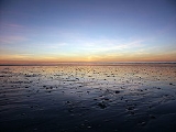
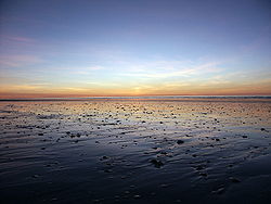
Eighty Mile Beach, Western Australia
Encyclopedia
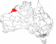
Western Australia
Western Australia is a state of Australia, occupying the entire western third of the Australian continent. It is bounded by the Indian Ocean to the north and west, the Great Australian Bight and Indian Ocean to the south, the Northern Territory to the north-east and South Australia to the south-east...
about half-way between the towns of Broome
Broome, Western Australia
Broome is a pearling and tourist town in the Kimberley region of Western Australia, north of Perth. The year round population is approximately 14,436, growing to more than 45,000 per month during the tourist season...
and Port Hedland
Port Hedland, Western Australia
Port Hedland is the highest tonnage port in Australia and largest town in the Pilbara region of Western Australia, with a population of approximately 14,000 ....
. It is a beach some 220 kilometres (136.7 mi) in length, forming the coastline where the Great Sandy Desert
Great Sandy Desert
The Great Sandy Desert is a desert located in the North West of Western Australia straddling the Pilbara and southern Kimberley regions. It is the second largest desert in Australia after the Great Victoria Desert and encompasses an area of...
approaches the Indian Ocean
Indian Ocean
The Indian Ocean is the third largest of the world's oceanic divisions, covering approximately 20% of the water on the Earth's surface. It is bounded on the north by the Indian Subcontinent and Arabian Peninsula ; on the west by eastern Africa; on the east by Indochina, the Sunda Islands, and...
. It is one of the most important sites for migratory shorebirds
Wader
Waders, called shorebirds in North America , are members of the order Charadriiformes, excluding the more marine web-footed seabird groups. The latter are the skuas , gulls , terns , skimmers , and auks...
, or waders, in Australia, and is recognised as a wetland of international importance under the Ramsar Convention on Wetlands
Ramsar Convention
The Ramsar Convention is an international treaty for the conservation and sustainable utilization of wetlands, i.e., to stem the progressive encroachment on and loss of wetlands now and in the future, recognizing the fundamental ecological functions of wetlands and their economic, cultural,...
.
Traditional ownership and usage
The southern section of Eighty Mile Beach is part of the traditional territory of the Nyangumarta PeopleNyangumarta language
Nyangumarta is spoken by Indigenous Australians in the region of Western Australia to the south and east of Lake Waukarlykarly, including Eighty Mile Beach, and part of the Great Sandy Desert inland to near Telfer.-Classification:...
, who maintain a strong connection to the area with many songs, stories and ceremonies associated with sites along and in the vicinity of the beach. In June 2009 the Federal Court of Australia
Federal Court of Australia
The Federal Court of Australia is an Australian superior court of record which has jurisdiction to deal with most civil disputes governed by federal law , along with some summary criminal matters. Cases are heard at first instance by single Judges...
determined that the Nyangumarta People were the valid native title
Native title
Native title is the Australian version of the common law doctrine of aboriginal title.Native title is "the recognition by Australian law that some Indigenous people have rights and interests to their land that come from their traditional laws and customs"...
holders of that section of the beach. The judgement of the Court was delivered on country at Nyiyamarri Pukurl, a site adjacent to the Eighty Mile Beach Caravan Park.
Traditional ownership of the northern part of Eighty Mile Beach, within the vicinity of the Anna Plains pastoral lease, is currently contested as between the Nyangumarta People
Nyangumarta language
Nyangumarta is spoken by Indigenous Australians in the region of Western Australia to the south and east of Lake Waukarlykarly, including Eighty Mile Beach, and part of the Great Sandy Desert inland to near Telfer.-Classification:...
and the Karajarri
Garadjari language
-Name:The name has many spelling variants, including:*Garadjari *Garadjiri*Garadyari*Garadyaria*Gard'are*Guradjara*Karadjeri...
(or Garadjari) People. The two groups have overlapping native title
Native title
Native title is the Australian version of the common law doctrine of aboriginal title.Native title is "the recognition by Australian law that some Indigenous people have rights and interests to their land that come from their traditional laws and customs"...
claims in this area.
In the Karajarri language, Eighty Mile Beach is called Wender, meaning “a creaking noise”, with reference to the sound of walking through dry sand. Many Aboriginal people
Indigenous Australians
Indigenous Australians are the original inhabitants of the Australian continent and nearby islands. The Aboriginal Indigenous Australians migrated from the Indian continent around 75,000 to 100,000 years ago....
with connections to the area now live at the Bidyadanga Community (formerly the La Grange Mission
La Grange Bay, Western Australia
Lagrange Bay is located south of Broome, Western Australia in the Kimberley region. It is the site of the Catholic Pallotine ‘’’La Grange Mission’’, and the Aboriginal community of Bidyadanga...
) and nearby at Frazier Downs. Several soaks
Soakage
A soakage, or soak, is a source of water in Australian deserts.It is called thus because the water generally seeps into the sand, and is stored below, sometimes as part of an ephemeral river or creek system.-Aboriginal water source:...
, known as lirri, lie behind the beach and were traditionally important as sources of fresh water. Many of the soaks became Water Reserves on the Kimberley-De Grey Stock Route
Stock route
In Australia, the Travelling Stock Route is an authorised thoroughfare for the walking of domestic livestock such as sheep or cattle from one location to another...
, which was used until the 1960s for long distance cattle
Cattle
Cattle are the most common type of large domesticated ungulates. They are a prominent modern member of the subfamily Bovinae, are the most widespread species of the genus Bos, and are most commonly classified collectively as Bos primigenius...
-droving
Droving
Droving is the practice of moving livestock over large distances by walking them "on the hoof".Droving stock to market, usually on foot and often with the aid of dogs, has a very long history in the old world...
.
Military use
The Talgarno military base, east of Anna Plains homestead, was important in the post-Second World War period for the monitoring and recovery of BritishUnited Kingdom
The United Kingdom of Great Britain and Northern IrelandIn the United Kingdom and Dependencies, other languages have been officially recognised as legitimate autochthonous languages under the European Charter for Regional or Minority Languages...
Blue Streak rockets, test-fired from Woomera, South Australia
Woomera, South Australia
The town, or village, of Woomera is located in the south east corner of the Woomera Prohibited Area ; colloquially known as the Woomera Rocket Range...
. A gravel airstrip, artesian bores and concrete blockhouses remain. In 1999 the Department of Defence
Department of Defence (Australia)
The Australian Department of Defence is a Federal Government Department. It forms part of the Australian Defence Organisation along with the Australian Defence Force . The Defence mission is to defend Australia and its national interests...
test-fired a missile from a site on Anna Plains, in connection with the development of the Jindalee over-the-horizon radar project
Jindalee Operational Radar Network
The Jindalee Operational Radar Network is an over-the-horizon radar network that can monitor air and sea movements across 37,000 km2. It has an official range of 3,000 km. It is used in the defence of Australia and can also monitor maritime operations, wave heights and wind directions...
.
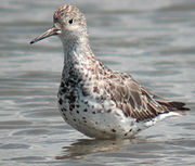
Shorebird research
Because of its importance for shorebirds, Eighty Mile Beach is classified as an Important Bird AreaImportant Bird Area
An Important Bird Area is an area recognized as being globally important habitat for the conservation of bird populations. Currently there are about 10,000 IBAs worldwide. The program was developed and sites are identified by BirdLife International...
(IBA) and is one of the principal shorebird study sites in north-western Australia. It regularly supports over 400,000 shorebirds, including over 1% of the global populations of Bar-tailed Godwit
Bar-tailed Godwit
The Bar-tailed Godwit is a large wader in the family Scolopacidae, which breeds on Arctic coasts and tundra mainly in the Old World, and winters on coasts in temperate and tropical regions of the Old World...
s, Eastern Curlews, Great Knot
Great Knot
The Great Knot, Calidris tenuirostris, is a small wader. It is the largest of the calidrid species.Their breeding habitat is tundra in northeast Siberia. They nest on the ground laying about four eggs in a ground scrape. They are strongly migratory wintering on coasts in southern Asia through to...
s, Red Knot
Red Knot
The Red Knot, Calidris canutus , is a medium sized shorebird which breeds in tundra and the Arctic Cordillera in the far north of Canada, Europe, and Russia. It is a large member of the Calidris sandpipers, second only to the Great Knot...
s, Red-necked Stint
Red-necked Stint
The Red-necked Stint is a small migratory wader.- Description :These birds are among the smallest of waders, very similar to the Little Stint, Calidris minuta, with which they were once considered conspecific...
s, Grey-tailed Tattler
Grey-tailed Tattler
The Grey-tailed Tattler, Tringa brevipes , is a small shorebird.- Description :...
s, Terek Sandpiper
Terek Sandpiper
The Terek Sandpiper is a small migratory Palearctic wader species, the only member of the genus Xenus.- Description and systematics :...
s, Pied Oystercatcher
Pied Oystercatcher
The Pied Oystercatcher, Haematopus longirostris, is a species of oystercatcher. It is a wading bird native to Australia and commonly found on its coastline. The similar South Island Pied Oystercatcher The Pied Oystercatcher, Haematopus longirostris, is a species of oystercatcher. It is a wading...
s, Greater Sand Plover
Greater Sand Plover
The Greater Sand Plover, Charadrius leschenaultii, is a small wader in the plover family of birds. The spelling is commonly given as "Greater sandplover", but the official British Ornithologists' Union spelling is "Greater sand plover"....
s, Oriental Plover
Oriental Plover
The Oriental Plover, Charadrius veredus, also known as the Oriental Dotterel, is a medium-sized Charadriine plover closely related to the Caspian Plover.- Description :...
s, Red-capped Plover
Red-capped Plover
The Red-capped Plover , also known as the Red-capped Dotterel, is a small plover. It breeds in Australia. The species is closely related to the Kentish Plover, Javan Plover and White-fronted Plover.-Description:Red-capped Plovers have white underparts and forehead...
s and Oriental Pratincole
Oriental Pratincole
The Oriental Pratincole , also known as the Grasshopper-Bird or Swallow-Plover is a wader in the pratincole family, Glareolidae....
s, with irregular high counts of other species. Since 1981 almost yearly expeditions by the Australasian Wader Studies Group
Australasian Wader Studies Group
The Australasian Wader Studies Group , established in 1981, is a special interest group of the Royal Australasian Ornithologists Union, also known as Birds Australia. It publishes a journal, The Stilt, usually twice a year, with occasional extra issues...
have been banding
Bird ringing
Bird ringing or bird banding is a technique used in the study of wild birds, by attaching a small, individually numbered, metal or plastic tag to their legs or wings, so that various aspects of the bird's life can be studied by the ability to re-find the same individual later...
and counting shorebirds there as part of a long-term program of monitoring the populations using the East Asian – Australasian Flyway. Since 1992 most birds caught have also been leg-flagged in order to discover their precise migration routes and staging sites.
Geography
Shire of Broome
The Shire of Broome is one of the four Local Government Areas in the Kimberley region of northern Western Australia, covering an area of , most of which is sparsely populated. The shire's estimated population in 2010 was 16,298, most of whom reside in the town of Broome...
in the Kimberley region of Western Australia
Kimberley region of Western Australia
The Kimberley is one of the nine regions of Western Australia. It is located in the northern part of Western Australia, bordered on the west by the Indian Ocean, on the north by the Timor Sea, on the south by the Great Sandy and Tanami Deserts, and on the east by the Northern Territory.The region...
, in the Dampierland
Dampierland
Dampierland is an Interim Biogeographic Regionalisation for Australia region in Western Australia. This area also is a distinct physiographic section of the larger Nullagine Platform province, which in turn is part of the larger West Australian Shield division.It is located in the West Kimberley ...
bioregion
Ecoregion
An ecoregion , sometimes called a bioregion, is an ecologically and geographically defined area that is smaller than an ecozone and larger than an ecosystem. Ecoregions cover relatively large areas of land or water, and contain characteristic, geographically distinct assemblages of natural...
. It extends south-west from Cape Missiessy 19°03′S 121°31′E in a shallow curve to Cape Keraudren 19°58′S 119°46′E, with its mid-point at 19°37′S 120°59′E. The beach is about 100 m wide and has a gentle gradient. It consists of sand with a high proportion of shelly
Mollusc shell
The mollusc shell is typically a calcareous exoskeleton which encloses, supports and protects the soft parts of an animal in the phylum Mollusca, which includes snails, clams, tusk shells, and several other classes...
material, and experiences a very large tidal range
Tidal range
The tidal range is the vertical difference between the high tide and the succeeding low tide. Tides are the rise and fall of sea levels caused by the combined effects of the gravitational forces exerted by the Moon and the Sun and the rotation of the Earth...
with an amplitude
Amplitude
Amplitude is the magnitude of change in the oscillating variable with each oscillation within an oscillating system. For example, sound waves in air are oscillations in atmospheric pressure and their amplitudes are proportional to the change in pressure during one oscillation...
of up to 9 m. The adjoining tidal mudflats vary from 1 to 5 km in width. On the landward side it is bordered by dune
Dune
In physical geography, a dune is a hill of sand built by wind. Dunes occur in different forms and sizes, formed by interaction with the wind. Most kinds of dunes are longer on the windward side where the sand is pushed up the dune and have a shorter "slip face" in the lee of the wind...
s, a narrow floodplain
Floodplain
A floodplain, or flood plain, is a flat or nearly flat land adjacent a stream or river that stretches from the banks of its channel to the base of the enclosing valley walls and experiences flooding during periods of high discharge...
and, further inland, by a strip of pindan
Pindan
Pindan is a name given to the red-soil country of the south-western Kimberley region of Western Australia. The word “pindan” was first mentioned in print in August 1884 in the Perth Inquirer...
woodland
Woodland
Ecologically, a woodland is a low-density forest forming open habitats with plenty of sunlight and limited shade. Woodlands may support an understory of shrubs and herbaceous plants including grasses. Woodland may form a transition to shrubland under drier conditions or during early stages of...
or shrubland
Shrubland
Shrubland, scrubland, scrub or brush is a plant community characterized by vegetation dominated by shrubs, often also including grasses, herbs, and geophytes. Shrubland may either occur naturally or be the result of human activity...
. Most of the land along the coast is covered by four large pastoral lease
Pastoral lease
A pastoral lease is Crown land that government allows to be leased, generally for the purposes of farming.-Australia:Pastoral leases exist in both Australian commonwealth law and state jurisdictions....
s: Anna Plains
Anna Plains Station
Anna Plains Station is a cattle station on the Western Australian coast 250 km south of Broome. It lies in the Shire of Broome in the Kimberley region and in the Dampierland bioregion...
, Mandora
Mandora Station
Mandora Station is a cattle station on the Western Australia coast south of Broome, located in the Shire of Broome. It maintains a weather station and is noted for the Mandora Marsh wetland, and for its proximity to Eighty Mile Beach, which are key stopping places for migratory birds.Mandora...
, Wallal
Wallal
Wallal is the location of a bore in the Kimberley region of Western Australia.The bore is located from the Great Northern Highway between Port Hedland and Broome and has an elevation of . The nearest town is Marble Bar which is situated South of the bore....
and Pardoo
Pardoo Station
Pardoo Station is a pastoral lease, formerly a sheep station, and now a cattle station approximately 120 km to the east of Port Hedland, Western Australia.-Description:...
, which are operated principally as cattle station
Cattle station
Cattle station is an Australian term for a large farm , whose main activity is the rearing of cattle. In Australia, the owner of a cattle station is called a grazier...
s.
Climate
The climate is semi-arid monsoonMonsoon
Monsoon is traditionally defined as a seasonal reversing wind accompanied by corresponding changes in precipitation, but is now used to describe seasonal changes in atmospheric circulation and precipitation associated with the asymmetric heating of land and sea...
al with a hot wet summer and a warm dry winter. Median and mean annual rainfall are 327 mm and 341 mm respectively, with annual evaporation about 3500 mm. There is much variability in rainfall, with significant variation between years as well as the period when the bulk of the rain falls; much is contributed by tropical cyclone
Tropical cyclone
A tropical cyclone is a storm system characterized by a large low-pressure center and numerous thunderstorms that produce strong winds and heavy rain. Tropical cyclones strengthen when water evaporated from the ocean is released as the saturated air rises, resulting in condensation of water vapor...
s, especially from January to March.
Ramsar site
Some 1,750 km2 of the beach and adjoining land, as well as the Mandora Marsh, was designated Ramsar Site 480 on 7 June 1990Mandora Marsh
Mandora Marsh, also known as the Mandora Salt Marsh, is a diverse wetland complex based on a palaeo-river system. It lies on Mandora StationMandora Station
Mandora Station is a cattle station on the Western Australia coast south of Broome, located in the Shire of Broome. It maintains a weather station and is noted for the Mandora Marsh wetland, and for its proximity to Eighty Mile Beach, which are key stopping places for migratory birds.Mandora...
, with the western end some 30 km from Eighty Mile Beach, beginning on the inland side of the Great Northern Highway
Great Northern Highway
The Great Northern Highway is a generally north-south Western Australian highway which links the state's capital Perth with its most northern port, Wyndham. It is in length, with being National Highway...
, at the western edge of the Great Sandy Desert
Great Sandy Desert
The Great Sandy Desert is a desert located in the North West of Western Australia straddling the Pilbara and southern Kimberley regions. It is the second largest desert in Australia after the Great Victoria Desert and encompasses an area of...
, in which bioregion it lies. Although it is included in the Eighty Mile Beach Ramsar Site, its environmental values are somewhat different and it is covered by its own article.
Eighty Mile Beach
Flora
Along the beach, the primary dunes are stabilised by Green BirdflowerCrotalaria cunninghamii
Crotalaria cunninghamii, also known as Green Birdflower or Regal Birdflower, is a plant of the legume family Fabaceae. It is native to, and widespread in, inland northern Australia. It is named after early 19th century botanist Allan Cunningham. It is a coloniser of unstable sand dunes, along...
and Beach Spinifex
Spinifex longifolius
Spinifex longifolius, commonly known as Beach Spinifex, is a perennial grass that grows along the northern and eastern rim of the Indian Ocean.-Description:It grows as a tussock from 30 centimetres to a metre high, and up to two metres wide...
. Secondary parallel, calcareous dune ridges and swales commonly feature scattered Dune Wattle
Acacia bivenosa
Acacia bivenosa, commonly known as Dune Wattle or Two-nerved Wattle, is an Australian shrub normally 1-3 m in height, sometimes reaching 5m...
. Significant grasses include Whiteochloa airoides and the local endemic Triodia epactia, a resinous hummock-forming species. Inland grasslands have been strongly modified by intensive cattle grazing
Grazing
Grazing generally describes a type of feeding, in which a herbivore feeds on plants , and also on other multicellular autotrophs...
and are dominated by introduced
Introduced species
An introduced species — or neozoon, alien, exotic, non-indigenous, or non-native species, or simply an introduction, is a species living outside its indigenous or native distributional range, and has arrived in an ecosystem or plant community by human activity, either deliberate or accidental...
Buffel Grass and Birdwood Grass.
Fauna
The principal conservation value of Eighty Mile Beach lies in the presence of very large numbers of shorebirds, for which it is one of the most important non-breeding and migratory stop-over areas in the East Asian – Australasian Flyway, regularly supporting more than 400,000 birds and especially important as a landfall for birds migrating southwards from their high latitude breeding grounds in northern AsiaNorth Asia
North Asia or Northern Asia is a subregion of Asia, consisting of the Asian portion of Russia.The Phillips Illustrated Atlas of the World 1988 defines it as being most of the former USSR, the part that is to the east of the Ural Mountains...
and Alaska
Alaska
Alaska is the largest state in the United States by area. It is situated in the northwest extremity of the North American continent, with Canada to the east, the Arctic Ocean to the north, and the Pacific Ocean to the west and south, with Russia further west across the Bering Strait...
to spend the austral
Southern Hemisphere
The Southern Hemisphere is the part of Earth that lies south of the equator. The word hemisphere literally means 'half ball' or "half sphere"...
summer
Summer
Summer is the warmest of the four temperate seasons, between spring and autumn. At the summer solstice, the days are longest and the nights are shortest, with day-length decreasing as the season progresses after the solstice...
in Australia. It is one of the most important sites in the world for the migration of Great Knot
Great Knot
The Great Knot, Calidris tenuirostris, is a small wader. It is the largest of the calidrid species.Their breeding habitat is tundra in northeast Siberia. They nest on the ground laying about four eggs in a ground scrape. They are strongly migratory wintering on coasts in southern Asia through to...
and it supports at least 1% of the flyway population (or 1% of the national population for non-migratory species) of 17 waders and the Caspian Tern
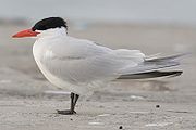
Caspian Tern
The Caspian Tern is a species of tern, with a subcosmopolitan but scattered distribution. Despite its extensive range, it is monotypic of its genus, and has no subspecies accepted either...
. The most abundant shorebird species at the beach are the Great Knot (up to 169,000 counted), Bar-tailed Godwit
Bar-tailed Godwit
The Bar-tailed Godwit is a large wader in the family Scolopacidae, which breeds on Arctic coasts and tundra mainly in the Old World, and winters on coasts in temperate and tropical regions of the Old World...
(110,000), and Red Knot
Red Knot
The Red Knot, Calidris canutus , is a medium sized shorebird which breeds in tundra and the Arctic Cordillera in the far north of Canada, Europe, and Russia. It is a large member of the Calidris sandpipers, second only to the Great Knot...
(80,000). Other notable species include Curlew Sandpiper
Curlew Sandpiper
The Curlew Sandpiper is a small wader that breeds on the tundra of Arctic Siberia. It is strongly migratory, wintering mainly in Africa, but also in south and southeast Asia and in Australasia...
(60,000), Red-necked Stint
Red-necked Stint
The Red-necked Stint is a small migratory wader.- Description :These birds are among the smallest of waders, very similar to the Little Stint, Calidris minuta, with which they were once considered conspecific...
(60,000), Large Sand Plover (64,000) and Oriental Plover
Oriental Plover
The Oriental Plover, Charadrius veredus, also known as the Oriental Dotterel, is a medium-sized Charadriine plover closely related to the Caspian Plover.- Description :...
(57,000) on the beach, Sharp-tailed Sandpiper
Sharp-tailed Sandpiper
The Sharp-tailed Sandpiper, Calidris acuminata is a small wader.- Taxonomy :More recently, a review of new data has indicated that this bird should perhaps better be placed into the genus Philomachus- as P...
(25,000) at both the beach and floodplain swamps, and Little Curlew
Little Curlew
The Little Curlew, Numenius minutus, is a wader in the large bird family Scolopacidae. It is a very small curlew, which breeds in the far north of Siberia. It is closely related to the North American Eskimo Curlew....
(12,000) on the floodplain.
Flatback Turtle
Flatback Turtle
The flatback sea turtle is a sea turtle that is endemic to the continental shelf of Australia. Flatback turtles belong to the Cheloniidae, or sea turtle, superfamily and are the only species found in the genus Natator....
s nest along Eighty-mile Beach at scattered locations between October and April. Coastal plains in the southern part of Anna Plains Station are a stronghold for Australian Bustard
Australian Bustard
The Australian Bustard, Ardeotis australis, is a large ground bird of grassland, woodland and open agricultural country across northern Australia and southern New Guinea. It is also commonly referred to in Central Australia as the Bush Turkey, particularly by Aboriginal people.The male is up to ...
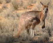
s and support high densities of Red Kangaroos. The western part of Wallal Downs has a dense population of Euros
Eastern Wallaroo
The Eastern Wallaroo also known as the Common Wallaroo or the Hill Wallaroo is part of the Wallaroo family . It is a large, variable species of macropod ....
.
Tourism and access
Eighty Mile Beach is subject to a relatively low but increasing amount of tourismTourism
Tourism is travel for recreational, leisure or business purposes. The World Tourism Organization defines tourists as people "traveling to and staying in places outside their usual environment for not more than one consecutive year for leisure, business and other purposes".Tourism has become a...
. A caravan park has been established on Wallal Downs at one of the access points to the beach, 250 km north of Port Hedland and 365 km south of Broome. It is used for fishing
Recreational fishing
Recreational fishing, also called sport fishing, is fishing for pleasure or competition. It can be contrasted with commercial fishing, which is fishing for profit, or subsistence fishing, which is fishing for survival....
, seashell
Seashell
A seashell or sea shell, also known simply as a shell, is a hard, protective outer layer created by an animal that lives in the sea. The shell is part of the body of the animal. Empty seashells are often found washed up on beaches by beachcombers...
collecting and other beach-based recreation.
Sources
- Livesey, N. J. G. (1993) Eighty-Mile Beach Area : supporting documentation for inclusion on the register of the National Estate : report to the Australian Heritage Commission and the Heritage Council of Western Australia, August 1993 Murdoch, W.A. : Murdoch University. NEDP documentation ; no. 3:93
- Stewart, R. R. (2005) Biophysical resource assessment of the Canning Coast, WA, including Roebuck Bay, Lagrange Bay and Eighty Mile Beach other authors - K. Fitzgerald and P. Kindleysides. Fremantle, W.A. : Dept. of Conservation and Land Management, Marine Conservation Branch,'"Data report: MRI/CAN,EMB/RBL,EMB-66/2005"