
Lugton Water
Encyclopedia
River Garnock
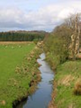
The River Garnock, the smallest of Ayrshire's six principal rivers, has its source on the southerly side of the Hill of Stake in the heart of the Clyde Muirshiel Regional Park. About a mile and a half south of this starting point the untested stream tumbles over the Spout of Garnock, the highest...
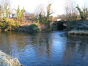
, runs 14 miles (22.5 km) from Loch Libo (395 feet above sea-level) in Uplawmoor
Uplawmoor
Uplawmoor is a village in East Renfrewshire, Scotland. Population 590 .Historic Uplawmoor, associated for centuries with the Barony of Caldwell and the Mure family, is still a vibrant community today, although now bereft of many of the services once to be found there...
, through Lugton
Lugton
Lugton is a small village or hamlet in East Ayrshire, Scotland with a population of 80 people. The A736 road runs through on its way from Glasgow, to the north, to Irvine in North Ayrshire. Uplawmoor is the first settlement on this 'Lochlibo Road' to the north and Burnhouse is to the south...
and the parishes of Neilston, Beith, Dunlop, Stewarton and Kilwinning. The Lugton joins the Garnock below the tidal limit, shortly after passing through Eglinton Country Park
Eglinton Country Park
Eglinton Country Park is located in the grounds of the old Eglinton Castle estate, Kilwinning, North Ayrshire, Scotland . Eglinton Park is situated in the parish of Kilwinning, part of the former district of Cunninghame, and covers an area of 400 hectares...
, developed around the ancient estate of the Earl of Eglinton.
Timothy Pont
Timothy Pont
Timothy Pont was a Scottish topographer, the first to produce a detailed map of Scotland. Pont's maps are among the earliest surviving to show a European country in minute detail, from an actual survey.-Life:...
refers to it as the 'Ludgar' or 'Lugdurr'. Loch Libo in the 14th century was referred to as Loch le Bog Syde in a charter, meaning the Bogside Loch.
The Duniflat Burn joins the Lugton Water from the East Ayrshire side close to the North Biggart bridge near where the Bells Burn from Bells Bog on the East Renfrewshire side also has its confluence.
The Bungle Burn, an outflow of the Blae Loch
Blae Loch, Beith
- Natural history :The site is a designated 'Local Wildlife Site' following a survey in 1981 by the Scottish Wildlife Trust and others. The survey recorded that the site is a 'Phragmites dominated area with open water'. The surveyors record that "The loch is surrounded to a great extent by bed of...
, joins the Lugton Water near the Bungleburn Bridge outside the village of Burnhouse
Barony and Castle of Giffen
The Barony of Giffen and its associated 15th-century castle were in the parish of Beith in the former District of Cunninghame, now North Ayrshire. The site may be spelled Giffen or Giffin and lay within the Lordship of Giffin, which included the Baronies of Giffen, Trearne, Hessilhead, Broadstone,...
.
The river runs past Eglinton Loch
Eglinton Loch
Eglinton Loch is a small freshwater loch in the North Ayrshire Council Areas , lying in a holm of the Lugton Water near Irvine and Kilwinning, within Eglinton Country Park, in the parish of Kilwinning...
within Eglinton Country Park
Eglinton Country Park
Eglinton Country Park is located in the grounds of the old Eglinton Castle estate, Kilwinning, North Ayrshire, Scotland . Eglinton Park is situated in the parish of Kilwinning, part of the former district of Cunninghame, and covers an area of 400 hectares...
and at times of heavy flood its waters enter the loch.
It contains fresh-water and sea-trout and the occasional salmon.