

Earthquakes in Guatemala
Encyclopedia
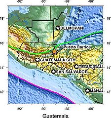
Guatemala
Guatemala is a country in Central America bordered by Mexico to the north and west, the Pacific Ocean to the southwest, Belize to the northeast, the Caribbean to the east, and Honduras and El Salvador to the southeast...
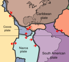
. The country lies in a major fault zone, known as the Motagua
Motagua Fault
The Motagua Fault is a major, active left lateral-moving transform fault which cuts across Guatemala. It forms part of the tectonic boundary between the North American Plate and the Caribbean Plate...
and Chixoy-Polochic
Chixoy-Polochic Fault
The Chixoy-Polochic Fault, also known as Cuilco-Chixoy-Polochic Fault, is a major fault zone in Guatemala and southwestern Mexico. It runs in a light arc from the east coast of Guatemala to Chiapas, following the deep valleys of the Polochic River, Chixoy River and Cuilco River.The Chixoy-Polochic...
fault complex, which cuts across Guatemala and forms the tectonic boundary between the Caribbean plate
Caribbean Plate
The Caribbean Plate is a mostly oceanic tectonic plate underlying Central America and the Caribbean Sea off the north coast of South America....
and the North American plate
North American Plate
The North American Plate is a tectonic plate covering most of North America, Greenland, Cuba, Bahamas, and parts of Siberia, Japan and Iceland. It extends eastward to the Mid-Atlantic Ridge and westward to the Chersky Range in eastern Siberia. The plate includes both continental and oceanic crust...
. In addition, along Guatemala's western coast line, the Cocos plate
Cocos Plate
The Cocos Plate is an oceanic tectonic plate beneath the Pacific Ocean off the west coast of Central America, named for Cocos Island, which rides upon it.-Geology:...
pushes against the Caribbean plate
Caribbean Plate
The Caribbean Plate is a mostly oceanic tectonic plate underlying Central America and the Caribbean Sea off the north coast of South America....
forming a subduction zone known as the Middle America Trench
Middle America Trench
The Middle America Trench is a major subduction zone, an oceanic trench in the eastern Pacific Ocean off the southwestern coast of Middle America, stretching from central Mexico to Costa Rica...
, located approximately 50 km off Guatemala's Pacific coast. This subduction zone led to formation of the Central America Volcanic Arc, and is an important source of offshore earthquakes. Both these major tectonic processes have generated deformations within the Caribbean plate and produced secondary fault zones, like the Mixco, Jalpatagua, and Santa Catarina Pinula faults.
The most destructive earthquake in recent Guatemalan history was the 1976 quake
1976 Guatemala earthquake
The 1976 Guatemala earthquake struck on February 4, 1976 at 03:01:43 local time . It was a 7.5 Mw earthquake, centered in the Motagua Fault, about 160 km northeast of Guatemala City, Guatemala...
with a magnitude of 7.5 Mw
Moment magnitude scale
The moment magnitude scale is used by seismologists to measure the size of earthquakes in terms of the energy released. The magnitude is based on the seismic moment of the earthquake, which is equal to the rigidity of the Earth multiplied by the average amount of slip on the fault and the size of...
and a hypocenter
Hypocenter
The hypocenter refers to the site of an earthquake or a nuclear explosion...
depth of just 5 km. This shallow-focus earthquake, originating from the Motagua Fault, caused 23,000 fatalities, leaving 76,000 injured and causing widespread material damage. Surprisingly, the 7.9 Mw
Moment magnitude scale
The moment magnitude scale is used by seismologists to measure the size of earthquakes in terms of the energy released. The magnitude is based on the seismic moment of the earthquake, which is equal to the rigidity of the Earth multiplied by the average amount of slip on the fault and the size of...
earthquake of 1942 -though higher in magnitude- was much less destructive, in part because of its substantially deeper hypocenter depth of 60 km.
A number of earthquakes with low magnitudes caused major damage in very localized areas, which may in part be explained by their relatively shallow depth. This was the case with the 1985 Uspantán earthquake of 5.0 Mw
Moment magnitude scale
The moment magnitude scale is used by seismologists to measure the size of earthquakes in terms of the energy released. The magnitude is based on the seismic moment of the earthquake, which is equal to the rigidity of the Earth multiplied by the average amount of slip on the fault and the size of...
with a depth of 5 km, which destroyed most buildings in the town of Uspantán
Uspantán
Uspantán is a municipality in the Guatemalan department of El Quiché. It is one of the largest municipalities of El Quiché and stretches from the mountainous highlands in the South to the tropical lowlands in the North. The municipal seat is in Villa de San Miguel Uspantán with a population of 2,800...
, but caused little or no damage in the rest of the country.
Recent earthquakes
Guatemala is in constant earthquake activity. However, there are some earthquakes that are more notable due to the damage they've caused. Notable earthquakes in recent Guatemalan history include the following:| Antigua Guatemala
Antigua Guatemala
Antigua Guatemala is a city in the central highlands of Guatemala famous for its well-preserved Spanish Mudéjar-influenced Baroque architecture as well as a number of spectacular ruins of colonial churches...
| 7.4 Mi
| ~IX
|
| Modified Mercalli intensity estimated at IX
|
|- style valign="top"
| 1751 Guatemala earthquake
| 1751
| Antigua Guatemala
Antigua Guatemala
Antigua Guatemala is a city in the central highlands of Guatemala famous for its well-preserved Spanish Mudéjar-influenced Baroque architecture as well as a number of spectacular ruins of colonial churches...
|
|
|
|- style valign="top"
| 1765 Guatemala earthquake
| 1765-10-24
| Ostuncalco
Ostuncalco
Ostuncalco, full name San Juan Ostuncalco, is a municipality in the Quetzaltenango department of Guatemala. Beside Spanish local people speak the Mam language.La Victoria is a village in this department....
(Quetzaltenango
Quetzaltenango (department)
Quetzaltenango is a department in the western highlands of Guatemala. The capital is the city of Quetzaltenango, the second largest city in Guatemala. The inhabitants include Spanish-speaking Ladinos and the K'iche' and Mam Maya groups, both with their own Maya language...
)
| 7.6-8.2 Mi
| ~VII
|
| Modified Mercalli intensity estimated at VII. Duration of shaking reported at 7–8 minutes, which may indicate possible rupture up to Chiapas.
|
|- style valign="top"
| 1773 Guatemala earthquake
1773 Guatemala earthquake
The 1773 Guatemala earthquake struck Guatemala on July 29, 1773 and had an estimated epicentral intensity magnitude of 7.5 Mi. It was followed by numerous aftershocks which lasted until December 1773. The series of all these earthquakes is also referred to as the Santa Marta earthquake as it had...
| 1773-07-29
| Antigua Guatemala
Antigua Guatemala
Antigua Guatemala is a city in the central highlands of Guatemala famous for its well-preserved Spanish Mudéjar-influenced Baroque architecture as well as a number of spectacular ruins of colonial churches...
| 7.5 Mi
| ~VIII
|
| On July 29 of 1773, and the following months, a series of strong earthquakes shook Antigua Guatemala
Antigua Guatemala
Antigua Guatemala is a city in the central highlands of Guatemala famous for its well-preserved Spanish Mudéjar-influenced Baroque architecture as well as a number of spectacular ruins of colonial churches...
and left most of the city in rubble. Also called Santa Marta earthquakes.
|
|- style valign="top"
| 1816 Guatemala earthquake
| 1816-07-22
| Alta Verapaz
Alta Verapaz
Alta Verapaz is a department in the north central part of Guatemala. The capital and chief city of the department is Cobán. Verapaz is bordered to the north by El Petén, to the east by Izabal, to the south by Zacapa, El Progreso, and Baja Verapaz, and to the west by El Quiché.Also in Alta Verapaz...
(Chixoy-Polochic Fault
Chixoy-Polochic Fault
The Chixoy-Polochic Fault, also known as Cuilco-Chixoy-Polochic Fault, is a major fault zone in Guatemala and southwestern Mexico. It runs in a light arc from the east coast of Guatemala to Chiapas, following the deep valleys of the Polochic River, Chixoy River and Cuilco River.The Chixoy-Polochic...
)
| 7.5 Mi
| ~VII
|
| Modified Mercalli intensity estimated at VII, covering 13,000 km2
|
|- style valign="top"
| 1902 Guatemala earthquake
| 1902-04-18
20:23:50 hrs
| 14.90°N 91.50°W
Quetzaltenango
Quetzaltenango (department)
Quetzaltenango is a department in the western highlands of Guatemala. The capital is the city of Quetzaltenango, the second largest city in Guatemala. The inhabitants include Spanish-speaking Ladinos and the K'iche' and Mam Maya groups, both with their own Maya language...
| 7.5 Ms
|
| 25 [60]
| See also: 1902 Guatemala earthquake. This earthquake may be related to the colossal eruption of the Santa María volcano on 24-10-1902, which killed at least 5000 people.
| 800-2000
|- style valign="top"
| 1913 Guatemala earthquake
| 1913-03-08
08:55 hrs
| near Cuilapa
Cuilapa
Cuilapa, also known as Santa Rosa Cuilapa, is a town in Guatemala. It serves as the capital of the department of Santa Rosa and as the administrative seat for the surrounding municipality of Cuilapa.Cuilapa marks the midpoint of the American Continent....
Jalpatagua Fault
| 5.0
|
| 6.5 km
| Destroyed the town of Cuilapa
Cuilapa
Cuilapa, also known as Santa Rosa Cuilapa, is a town in Guatemala. It serves as the capital of the department of Santa Rosa and as the administrative seat for the surrounding municipality of Cuilapa.Cuilapa marks the midpoint of the American Continent....
| 60
|- style valign="top"
| 1917 Guatemala earthquake
| 1917-12-26
05:21:00 hrs
| Guatemala City
Guatemala City
Guatemala City , is the capital and largest city of the Republic of Guatemala and Central America...
| 5.6
| VII-IX
|
| Several foreshock
Foreshock
A foreshock is an earthquake that occurs before a larger seismic event and is related to it in both time and space. The designation of an earthquake as foreshock, mainshock or aftershock is only possible after the event....
s since November 27, 1917 have preceded this quake.
| 250
|- style valign="top"
| 1918 Guatemala earthquake
| 1918-01-04
04:30.10 and 04:32.25 LT
| near Guatemala City
Guatemala City
Guatemala City , is the capital and largest city of the Republic of Guatemala and Central America...
| 6.0
| VI
|
| Magnitude estimate by INSUVIMEH
|
|- style valign="top"
| 1942 Guatemala earthquake
| 1942-08-06
23:36.98 UTC
| 13.9°N 90.8°W
Western Guatemala
| 7.9
|
| 60 km
| 8.3 Ms, according to Insivumeh. 38 deaths, many injured, and widespread material damage. Additional damage due to landslides.
| 38
|- style valign="top"
| 1959 Guatemala earthquake
| 1959-02-20
18:16.33 UTC
| 15.94°N 90.59°W
Ixcán
Ixcán
Ixcán is a municipality in the Guatemalan department of El Quiché. Its administrative centre can be found in Playa Grande. The municipality consists of 176 communities, called aldeas. It has an area of 1575 km2...
|
|
| 48 km
|
|
|- style valign="top"
| 1976 Guatemala earthquake
1976 Guatemala earthquake
The 1976 Guatemala earthquake struck on February 4, 1976 at 03:01:43 local time . It was a 7.5 Mw earthquake, centered in the Motagua Fault, about 160 km northeast of Guatemala City, Guatemala...
| 1976-02-04
09:01 UTC
| 15.32°N 89.10°W
Motagua Fault
Motagua Fault
The Motagua Fault is a major, active left lateral-moving transform fault which cuts across Guatemala. It forms part of the tectonic boundary between the North American Plate and the Caribbean Plate...
| 7.5
| X
| 5 km
| Activated destructive aftershocks in the Mixco Fault near Guatemala City
Guatemala City
Guatemala City , is the capital and largest city of the Republic of Guatemala and Central America...
. See also:1976 Guatemala earthquake
1976 Guatemala earthquake
The 1976 Guatemala earthquake struck on February 4, 1976 at 03:01:43 local time . It was a 7.5 Mw earthquake, centered in the Motagua Fault, about 160 km northeast of Guatemala City, Guatemala...
| 23,000
|- style valign="top"
| 1985 Guatemala earthquake
| 1985-10-11
03:39.17 hrs
| 15.3°N 90.9°W
Uspantán
Uspantán
Uspantán is a municipality in the Guatemalan department of El Quiché. It is one of the largest municipalities of El Quiché and stretches from the mountainous highlands in the South to the tropical lowlands in the North. The municipal seat is in Villa de San Miguel Uspantán with a population of 2,800...
| 5.0
| VII
| 5 km
| Major damage in the town of Uspantán
Uspantán
Uspantán is a municipality in the Guatemalan department of El Quiché. It is one of the largest municipalities of El Quiché and stretches from the mountainous highlands in the South to the tropical lowlands in the North. The municipal seat is in Villa de San Miguel Uspantán with a population of 2,800...
(80% of buildings affected)
|
|- style valign="top"
| 1988 Guatemala earthquake
| 1988-11-03
14:14.10 hrs
| 13.881°N 90.450°W
San Vicente Pacaya
San Vicente Pacaya
San Vicente Pacaya is a municipality in the Escuintla department of Guatemala....
| 6.0
| VI
| 69 km
| 5 casualties
| 5
|- style valign="top"
| 1991 Guatemala earthquake
| 1991-09-11
03:48:13 hrs
| 14°24.12′N 91°03.06′W
Pochuta
Pochuta
Pochuta is a municipality in the Chimaltenango department of Guatemala....
| 5.3
| VII
| 32 km
| Destroyed 80% of the town of San Miguel Pochuta
Pochuta
Pochuta is a municipality in the Chimaltenango department of Guatemala....
| 25
|- style valign="top"
| 1993 Chiapas earthquake
| 1993-09-10
19:12:54 hrs
| 14.717°N 92.645°W
offshore Chiapas
Chiapas
Chiapas officially Estado Libre y Soberano de Chiapas is one of the 31 states that, with the Federal District, comprise the 32 Federal Entities of Mexico. It is divided in 118 municipalities and its capital city is Tuxtla Gutierrez. Other important cites in Chiapas include San Cristóbal de las...
, San Marcos department
| 7.2
|
| 34 km
| Caused 1 casualty and considerable material damage in southwestern Guatemala where some roads were blocked due to rockslides. Some damage in parts of Chiapas.
| 1
|- style valign="top"
| 1995 Guatemala earthquake
| 1995-12-19
14:56:06 hrs
| 15.301°N 90.154°W
Tucurú
Tucurú
Tucurú is a municipality in the Guatemalan department of Alta Verapaz....
| 5.3
| IV
| 10 km
|
| 1
|- style valign="top"
| 1998 Guatemala earthquake
| 1998-01-10
02:20:10 hrs
| 14.374°N 91.473°W
Santo Domingo Suchitepéquez
Santo Domingo Suchitepequez
Santo Domingo Suchitepéquez is a municipality in the Suchitepéquez department of Guatemala....
| 6.6
| VII, VI
| 33 km
| 16 people injured in Quezaltenango, 3 injured in San Marcos
San Marcos (department)
San Marcos is a department in Guatemala. The capital is the city of San Marcos.-Departmental history:The department was created by a governmental decree on 8 May 1866, together with Huehuetenango, Izabal and Petén departments...
, 5 injured in Guatemala city
Guatemala City
Guatemala City , is the capital and largest city of the Republic of Guatemala and Central America...
. Buildings damaged in the Quezaltenango and San Marcos Departments. A number of houses destroyed in Solola Department.
|
|- style valign="top"
| 1998 Guatemala earthquake (March)
| 1998-03-02
20:24:46 LT
| 13°52.92′N 91°52.38′W
offshore Pacific Ocean
Pacific Ocean
The Pacific Ocean is the largest of the Earth's oceanic divisions. It extends from the Arctic in the north to the Southern Ocean in the south, bounded by Asia and Australia in the west, and the Americas in the east.At 165.2 million square kilometres in area, this largest division of the World...
| 5.6
| V, III
| 33 km
|
|
|- style valign="top"
| 2007 Guatemala earthquake
2007 Guatemala earthquake
The 2007 Guatemala earthquake occurred on June 13, 2007 occurred at 19:29:46 UTC . The epicenter was located in the Pacific Ocean, south of Puerto Quetzal, about south-southwest of Guatemala City....
| 2007-06-13
02:29:41 hrs
| 13.623°N 90.797°W
offshore Pacific Ocean
Pacific Ocean
The Pacific Ocean is the largest of the Earth's oceanic divisions. It extends from the Arctic in the north to the Southern Ocean in the south, bounded by Asia and Australia in the west, and the Americas in the east.At 165.2 million square kilometres in area, this largest division of the World...
115 km southwest of Guatemala City
| 6.7
|
| 23 km
| See also: 2007 Guatemala earthquake
2007 Guatemala earthquake
The 2007 Guatemala earthquake occurred on June 13, 2007 occurred at 19:29:46 UTC . The epicenter was located in the Pacific Ocean, south of Puerto Quetzal, about south-southwest of Guatemala City....
| 0
|- style valign="top"
| 2008 Guatemala earthquake
| 2008-05-27
11:28:01 UTC
| 13.715°N 90.921°W
offshore Pacific Ocean
Pacific Ocean
The Pacific Ocean is the largest of the Earth's oceanic divisions. It extends from the Arctic in the north to the Southern Ocean in the south, bounded by Asia and Australia in the west, and the Americas in the east.At 165.2 million square kilometres in area, this largest division of the World...
120 km southwest of Guatemala City
| 5.7
|
| 78 km
|
|
|- style valign="top"
| 2009 Guatemala earthquake
| 2009-05-03
16:21:47 UTC
| 14.58°N 91.08°W
South of Patzún
Patzún
Patzún is a municipality in the Chimaltenango department of Guatemala.-External links:*http://www.patzun.gob.gt/portal/...
55 km (35 miles) ESE of Quezaltenango
| 6.2
|
| 124 km
|
|
|- style valign="top"
| 2010 Guatemala earthquake
| 2010-02-23
15:16:00 UTC
| 15.984°N 91.386°W
20 km north of San Mateo Ixtatán
San Mateo Ixtatán
San Mateo Ixtatán is a municipality in the Guatemalan department of Huehuetenango. It is situated at above sea level in the Cuchumatanes mountain range and covers of terrain. It has a cold climate and is located in a cloud forest. The temperature fluctuates between . The coldest months are from...
| 5.6
|
| 10 km
| The earthquake was preceded by a magnitude 5.3 quake on February 23, 2010 at 10:52:15 UTC with its epicentre located at 16.048°N 91.230°W (10 km depth) A magnitude 5.3 quake followed in the same region on March 20, 2010, at 16.047°N 91.236°W (82.4 km km depth).
| -
|-
|}
MM = Intensity on the Modified Mercalli scale
Sources
- Seismic data of Guatemala, Retrieved on July 28, 2008
- details on Historic Earthquakes in Guatemala. Retrieved on July 28, 2008.