

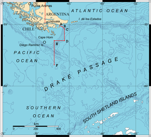
Drake Passage
Encyclopedia
Francisco de Hoces
Francisco de Hoces was a Spanish sailor who in 1525 joined the Loaísa Expedition to the Spice Islands as commander of the vessel San Lesmes....
—is the body of water between the southern tip of South America
South America
South America is a continent situated in the Western Hemisphere, mostly in the Southern Hemisphere, with a relatively small portion in the Northern Hemisphere. The continent is also considered a subcontinent of the Americas. It is bordered on the west by the Pacific Ocean and on the north and east...
at Cape Horn
Cape Horn
Cape Horn is the southernmost headland of the Tierra del Fuego archipelago of southern Chile, and is located on the small Hornos Island...
, Chile
Chile
Chile ,officially the Republic of Chile , is a country in South America occupying a long, narrow coastal strip between the Andes mountains to the east and the Pacific Ocean to the west. It borders Peru to the north, Bolivia to the northeast, Argentina to the east, and the Drake Passage in the far...
and the South Shetland Islands
South Shetland Islands
The South Shetland Islands are a group of Antarctic islands, lying about north of the Antarctic Peninsula, with a total area of . By the Antarctic Treaty of 1959, the Islands' sovereignty is neither recognized nor disputed by the signatories and they are free for use by any signatory for...
of Antarctica. It connects the southwestern part of the Atlantic Ocean
Atlantic Ocean
The Atlantic Ocean is the second-largest of the world's oceanic divisions. With a total area of about , it covers approximately 20% of the Earth's surface and about 26% of its water surface area...
(Scotia Sea
Scotia Sea
The Scotia Sea is partly in the Southern Ocean and mostly in the South Atlantic Ocean.-Location and description:Habitually stormy and cold, the Scotia Sea is the area of water between Tierra del Fuego, South Georgia, South Sandwich Islands, South Orkney Islands and the Antarctic Peninsula, and...
) with the southeastern part of the Pacific Ocean
Pacific Ocean
The Pacific Ocean is the largest of the Earth's oceanic divisions. It extends from the Arctic in the north to the Southern Ocean in the south, bounded by Asia and Australia in the west, and the Americas in the east.At 165.2 million square kilometres in area, this largest division of the World...
and extends into the Southern Ocean
Southern Ocean
The Southern Ocean comprises the southernmost waters of the World Ocean, generally taken to be south of 60°S latitude and encircling Antarctica. It is usually regarded as the fourth-largest of the five principal oceanic divisions...
.
The passage receives its English language name from the 16th century English
England
England is a country that is part of the United Kingdom. It shares land borders with Scotland to the north and Wales to the west; the Irish Sea is to the north west, the Celtic Sea to the south west, with the North Sea to the east and the English Channel to the south separating it from continental...
privateer
Privateer
A privateer is a private person or ship authorized by a government by letters of marque to attack foreign shipping during wartime. Privateering was a way of mobilizing armed ships and sailors without having to spend public money or commit naval officers...
Sir Francis Drake. Drake's only remaining ship, after having passed through the Strait of Magellan
Strait of Magellan
The Strait of Magellan comprises a navigable sea route immediately south of mainland South America and north of Tierra del Fuego...
, was blown far South in September of 1578. This incident implied an open connection between the Atlantic and Pacific oceans.
Half a century earlier, after a gale had pushed them South from the entrance of the Strait of Magellan, the crew of the Spanish
Spain
Spain , officially the Kingdom of Spain languages]] under the European Charter for Regional or Minority Languages. In each of these, Spain's official name is as follows:;;;;;;), is a country and member state of the European Union located in southwestern Europe on the Iberian Peninsula...
navigator Francisco de Hoces
Francisco de Hoces
Francisco de Hoces was a Spanish sailor who in 1525 joined the Loaísa Expedition to the Spice Islands as commander of the vessel San Lesmes....
thought they saw a land's end and possibly inferred this passage in 1525. For this reason, some Spanish and Latin America
Latin America
Latin America is a region of the Americas where Romance languages – particularly Spanish and Portuguese, and variably French – are primarily spoken. Latin America has an area of approximately 21,069,500 km² , almost 3.9% of the Earth's surface or 14.1% of its land surface area...
n historian
Historian
A historian is a person who studies and writes about the past and is regarded as an authority on it. Historians are concerned with the continuous, methodical narrative and research of past events as relating to the human race; as well as the study of all history in time. If the individual is...
s and sources call it Mar de Hoces after Francisco de Hoces.
The first recorded voyage through the passage was that of the Eendracht, captained by the Dutch navigator Willem Schouten
Willem Schouten
Willem Cornelisz Schouten was a Dutch navigator for the Dutch East India Company. He was the first to sail the Cape Horn route to the Pacific Ocean.- Biography :Willem Cornelisz Schouten was born in c...
in 1616, naming Cape Horn in the process.
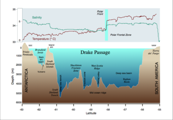
The 800 kilometres (497.1 mi) wide passage between Cape Horn and Livingston Island
Livingston Island (South Shetland Islands)
Livingston Island is an Antarctic island in the South Shetland Islands, Western Antarctica lying between Greenwich Island and Snow Islands...
is the shortest crossing from Antarctica to the rest of the world's land. The boundary between the Atlantic and Pacific Oceans is sometimes taken to be a line drawn from Cape Horn to Snow Island 130 kilometres (80.8 mi) north of mainland Antarctica). Alternatively the meridian that passes through Cape Horn may be taken as the boundary. Both boundaries lie entirely within the Drake Passage.
The other two passages around Cape Horn, Magellan Strait and Beagle Channel
Beagle Channel
thumb|right|300px|Aereal view of Beagle Channel. The Chilean [[Navarino Island]] is seen in the top-right while the Argentine part of [[Isla Grande de Tierra del Fuego]] is seen at the bottom-left....
, are very narrow, leaving little room for a ship, particularly a sailing ship
Sailing ship
The term sailing ship is now used to refer to any large wind-powered vessel. In technical terms, a ship was a sailing vessel with a specific rig of at least three masts, square rigged on all of them, making the sailing adjective redundant. In popular usage "ship" became associated with all large...
, to maneuver. They can also become ice
Ice
Ice is water frozen into the solid state. Usually ice is the phase known as ice Ih, which is the most abundant of the varying solid phases on the Earth's surface. It can appear transparent or opaque bluish-white color, depending on the presence of impurities or air inclusions...
bound, and sometimes the wind
Wind
Wind is the flow of gases on a large scale. On Earth, wind consists of the bulk movement of air. In outer space, solar wind is the movement of gases or charged particles from the sun through space, while planetary wind is the outgassing of light chemical elements from a planet's atmosphere into space...
blows so strongly no sailing
Sailing
Sailing is the propulsion of a vehicle and the control of its movement with large foils called sails. By changing the rigging, rudder, and sometimes the keel or centre board, a sailor manages the force of the wind on the sails in order to move the boat relative to its surrounding medium and...
vessel can make headway against it. Hence most sailing ships preferred the Drake Passage, which is open water for hundreds of miles, despite very rough conditions. The very small Diego Ramírez Islands
Diego Ramírez Islands
The Diego Ramírez Islands are a small group of lesser islands located in the southernmost extreme of Chile about south-west of Cape Horn and south-south-east of Ildefonso Islands, stretching north-south . Their land area is little more than...
lie about 50 kilometres (31.1 mi) south of Cape Horn.
There is no significant land anywhere around the world at the latitude
Latitude
In geography, the latitude of a location on the Earth is the angular distance of that location south or north of the Equator. The latitude is an angle, and is usually measured in degrees . The equator has a latitude of 0°, the North pole has a latitude of 90° north , and the South pole has a...
s of the Drake Passage, which is important to the unimpeded flow of the Antarctic Circumpolar Current
Antarctic Circumpolar Current
The Antarctic Circumpolar Current is an ocean current that flows from west to east around Antarctica. An alternative name for the ACC is the West Wind Drift. The ACC is the dominant circulation feature of the Southern Ocean and, at approximately 125 Sverdrups, the largest ocean current...
which carries a huge volume of water (about 600 times the flow of the Amazon River
Amazon River
The Amazon of South America is the second longest river in the world and by far the largest by waterflow with an average discharge greater than the next seven largest rivers combined...
) through the Passage and around Antarctica.
Ships in the passage are often good platforms for the sighting of whale
Whale
Whale is the common name for various marine mammals of the order Cetacea. The term whale sometimes refers to all cetaceans, but more often it excludes dolphins and porpoises, which belong to suborder Odontoceti . This suborder also includes the sperm whale, killer whale, pilot whale, and beluga...
s, dolphin
Dolphin
Dolphins are marine mammals that are closely related to whales and porpoises. There are almost forty species of dolphin in 17 genera. They vary in size from and , up to and . They are found worldwide, mostly in the shallower seas of the continental shelves, and are carnivores, mostly eating...
s and plentiful seabirds including giant petrel
Giant petrel
Giant petrels is a genus, Macronectes, from the family Procellariidae and consist of two species. They are the largest birds from this family...
s, other petrel
Petrel
Petrels are tube-nosed seabirds in the bird order Procellariiformes. The common name does not indicate relationship beyond that point, as "petrels" occur in three of the four families within that group...
s, albatross
Albatross
Albatrosses, of the biological family Diomedeidae, are large seabirds allied to the procellariids, storm-petrels and diving-petrels in the order Procellariiformes . They range widely in the Southern Ocean and the North Pacific...
es and penguin
Penguin
Penguins are a group of aquatic, flightless birds living almost exclusively in the southern hemisphere, especially in Antarctica. Highly adapted for life in the water, penguins have countershaded dark and white plumage, and their wings have become flippers...
s.
The passage is known to have been closed until around 41 million years ago according to a chemical study of fish
Fish
Fish are a paraphyletic group of organisms that consist of all gill-bearing aquatic vertebrate animals that lack limbs with digits. Included in this definition are the living hagfish, lampreys, and cartilaginous and bony fish, as well as various extinct related groups...
teeth found in ocean
Ocean
An ocean is a major body of saline water, and a principal component of the hydrosphere. Approximately 71% of the Earth's surface is covered by ocean, a continuous body of water that is customarily divided into several principal oceans and smaller seas.More than half of this area is over 3,000...
ic sedimentary rock
Sedimentary rock
Sedimentary rock are types of rock that are formed by the deposition of material at the Earth's surface and within bodies of water. Sedimentation is the collective name for processes that cause mineral and/or organic particles to settle and accumulate or minerals to precipitate from a solution....
. Before the passage opened, the Atlantic and Pacific Oceans were separated entirely with Antarctica being much warmer and having no ice cap
Ice cap
An ice cap is an ice mass that covers less than 50 000 km² of land area . Masses of ice covering more than 50 000 km² are termed an ice sheet....
. The joining of the two great oceans started the Antarctic Circumpolar Current
Antarctic Circumpolar Current
The Antarctic Circumpolar Current is an ocean current that flows from west to east around Antarctica. An alternative name for the ACC is the West Wind Drift. The ACC is the dominant circulation feature of the Southern Ocean and, at approximately 125 Sverdrups, the largest ocean current...
and cooled the continent
Continent
A continent is one of several very large landmasses on Earth. They are generally identified by convention rather than any strict criteria, with seven regions commonly regarded as continents—they are : Asia, Africa, North America, South America, Antarctica, Europe, and Australia.Plate tectonics is...
significantly.
See also
- Sir Francis Drake
- García de NodalGarcia de Nodal expeditionThe García de Nodal expedition was chartered in 1619 by King Philip III of Spain to reconnoiter the passage between the Atlantic and Pacific oceans, rounding Cape Horn, south of Tierra del Fuego, just discovered by the Dutch merchants Jacob Le Maire and Willem Schouten. It was a successful...
- Straits of Magellan
- Beagle ChannelBeagle Channelthumb|right|300px|Aereal view of Beagle Channel. The Chilean [[Navarino Island]] is seen in the top-right while the Argentine part of [[Isla Grande de Tierra del Fuego]] is seen at the bottom-left....