
Dhaka District
Encyclopedia
Dhaka District is a district
located in central Bangladesh
, and is the densest district in the nation. It is a part of the Dhaka Division. Dhaka
, the capital of Bangladesh, rests on the eastern banks of the Buriganga River
which flows from the Turag
to the south of the district. While Dhaka
(city) occupies only about a fifth of the area of Dhaka district, it is the economic, political and cultural centre of the district and the country as a whole.
and Tangail
to the north, Munshiganj
and Rajbari
to the south, Narayanganj
to the east and Manikganj
to the west. Main rivers flowing through this district are Padma
, Kaliganga
, Dhaleshwari
, Ichamati
, Shitalakshya
, Buriganga
and numerous smaller rivers including Bangshi, Turag, Balu, Elamjani, Alam, Bherujkha, Ramkrishnadi, Elisamari, Tulsikhali. Major lakes ("beels") include Belai, Saldaher, Labandaher, Churain, Damsharan and Kiranjir Beel. Annual average temperature of the district is maximum 34.5°C, minimum 11.5°C; average annual rainfall 1931mm. The population of the division reached 11,875,000 people as of Census 2011 preliminary figures, as with all past Censuses, numbers will be revised higher once more data comes in.
Dhaka (city)
has twenty-two thanas under its jurisdiction. They are:
The municipal area of Dhaka city is under the jurisdiction of the Dhaka City Corporation
; for administrative purposes, the municipal area is divided into 90 wards.
 The administrative Dhaka District was first established in 1772. But, the existence of urbanised settlements in the area that is now Dhaka city — dates from the 7th century. The present day Savar
was the capital of the Sanbagh Kingdom during seventh and eighth century. The city area of Dhaka was ruled by the Buddhist
kingdom of Kamarupa
and the Pala Empire
before passing to the control of the Hindu
Sena dynasty
in the 9th century. Many believe that the name of the city was derived after the establishment of the Goddess Dhakeshwari's temple by Ballal Sena
in the 12th century. Dhaka and its surrounding area was identified as Bengalla around that period. The town itself consisted of a few market centers like Lakshmi Bazar, Shankhari Bazar, Tanti Bazar, Patuatuli, Kumartuli, Bania Nagar and Goal Nagar. After the Sena dynasty, Dhaka was successively ruled by the Turkish
and Afghan
governors descending from the Delhi Sultanate
before the arrival of the Mughals in 1608.
The development of townships and a significant growth in population came as the city was proclaimed the capital of Bengal under Mughal
rule in 1608. During Mughal rule the areas currently under Dhaka district was famous for its textile products — especially the Muslin
. Mughal subahdar
Islam Khan
was the first administrator of the city. Khan named the town "Jahangir Nagar" (City of Jahangir) in honour of the Mughal emperor Jahangir
, although this name was dropped soon after Jahangir's death. The main expansion of the city took place under Mughal general Shaista Khan
. The city then measured 19 by 13 kilometres (12 by 8 mi), with a population of nearly a million people. The city passed to the control of the British East India Company
in 1757 after the Battle of Plassey
and eventually to the Crown
, British Empire
, in 1765 at the Battle of Buxer. The city's population shrank dramatically during this period as the prominence of Kolkata
rose, but substantive development and modernisation eventually followed. A modern civic water supply system was introduced in 1874 and electricity supply launched in 1878. The Dhaka Cantonment
was established near the city, serving as a base for British and Indian soldiers.
.jpg) During the abortive Partition of Bengal
During the abortive Partition of Bengal
in 1905, Dhaka was declared to be the capital of the newly established state of Eastern Bengal and Assam, but Bengal was reunited in 1911. The rural areas under present Dhaka district, especially Dohar Upazila
were used for the production of indigo
.
During 1920s the people of Dhaka District were influenced by the Non Co-operation Movement led by Mahatma Gandhi
. Avay Ashram was established at Dohar in 1922-23 following the ideals of Gandhi. The All India Convention of Gandhi Seba Sangha was held at village Malikandha of Dohar
in 1940. On this occasion Gandhi came here and stayed for two days.
Following the partition of Bengal in (1947) appending the partition of British India in 1947, Dhaka became the capital of East Bengal
as a part of the new Muslim state
of Pakistan
, while western part of Bengal with a majority Hindu population had become a part of the new and independent India, designated as West Bengal
with Calcutta as state capital. Calcutta witnessed communal violence that left thousands of people dead. A large proportion of the city's Hindu
population departed for India
, while the city received hundreds of thousands of Muslim
immigrants from Calcutta, India. The city's population rose dramatically in a very short period of time, which created severe shortages and infrastructural problems. As the centre of regional politics, Dhaka saw an increasing number of political strikes and incidents of violence. The adoption of Urdu
as the sole official language
of Pakistan led to protest marches involving large crowds. Known as the language movement of 1952
, the protests resulted in police firing which killed students who were demonstrating peacefully. Throughout the 1950s and '60s, Dhaka remained a hotbed of political activity, and the demands for autonomy for the Bengali population gradually gained momentum.
The 1970 Bhola cyclone
devastated much of the region, killing an estimated 500,000 people. More than half the city of Dhaka was flooded and millions of people marooned. With public anger growing against ethnic discrimination and poor cyclone relief efforts from the central government, Bengali politician Sheikh Mujibur Rahman
held a nationalist rally on March 7, 1971 at the Race Course Ground
. An estimated one million people attended the gathering, leading to Ziaur Rahman
's March 26 declaration of Bangladesh's independence. In response, the Pakistan Army
launched Operation Searchlight
, which led to the arrests, torture and killing of hundreds of thousands of people, mainly Hindus and Bengali
intellectuals.
During the Bangladesh Liberation War
the Pakistan
army arrested fourteen Muktijoddhas from Dhamrai
Bazar and brutally killed all of them at a place near Kalampur Bazar. A mass grave created during the war still exists in the western side of Kalampur Bazar. The Pak army also burnt down many houses in Konakhola, Basta, Brahmankirtha, Goalkhali and Khagail Kholamora villages of Keraniganj Upazila
.
The fall of Dhaka city to the allied forces led by Jagjit Singh Aurora
on December 16 marked the surrender of Pakistan army. The post-independence period has seen a rapid and massive growth of the city population, attracting migrant workers from rural areas across Bangladesh. A real estate boom has followed the expansion of city limits and the development of new settlements such as Gulshan, Banani and Motijheel
.
 Dhaka is the 3rd commercial heart of Bangladesh. The city has a large middle class population, increasing the market for modern consumer and luxury goods.
Many skilled workers are employed in the businesses and industries located in the Dhaka metropolitan area. The city has historically attracted a large number of migrant workers. Hawkers
, peddlers, small shops, rickshaws transport, roadside vendors and stalls employ a large segment of the population — rickshaw-drivers alone number as many as 400,000. Half the workforce is employed in household and unorganised labour, while about 800,000 work in the textile
industry. Even so, unemployment remains high at 23%. According to CityMayors Statisticshttp://www.citymayors.com/statistics/richest-cities-2005.html, Dhaka's GDP registered at $52 billion in 2005 with an annual growth rate of 6.1%. Its estimated GDP in the year 2020 is $126 billion. The annual per capita income of Dhaka is estimated at $550, although a large segment of the population lives below the poverty line, with many surviving on less than $3 a day.
The main business districts of the city include Motijheel
, Panthapath and Gulshan. Bashundhara City
is a recently developed economic area that houses many high-tech industries and corporations and a shopping mall that is one of the largest in Southeast Asia, frequented daily by more than 25,000 people. The Export Processing Zone in Dhaka was set up to encourage the export of garments, textiles and other goods. The EPZ is home to 80 factories, which employ mostly women. The Dhaka Stock Exchange
is based in the city, as are most of the large companies and banks of Bangladesh, including the Bangladesh Bank
, HSBC
, Citibank
and the Grameen Bank
. Urban developments have sparked a widespread construction boom, causing new high-rise buildings and skyscraper
s to change the city landscape. Growth has been especially strong in the finance, banking, manufacturing, telecommunications and services sectors, while tourism
, hotels and restaurants continue as important elements of the Dhaka economy.
is the capital of Bangladesh
and lies on the banks of the Buriganga River in the central area of Bangladesh. The old town of Dhaka, south of the city centre, is the site of most of the tourist attractions, including the Lalbagh Fort, the Stat Mosque, and the Ahsan Manzil
Palace Museum.
The city of Dhaka was predominantly a city of the Mughals, whose governors and viceroys built several palace, mosques and katrias. Dhaka's finest specimen of this time is the Aurangabad Fort, commonly known as Lalbaght Fort, incomplete but well worth for visit. Also in this area of Dhaka is the spectacular Ahsan Manzil Plance Museum, the Bara Katra
, the Cotta Katra and several mosques of note.
The old European quarter lies just north of Dhaka's old town, which houses the presidential place and the National Museum, Dhaka's commercial and diplomatic regions are north-east of this zone. Dhaka Zoo and the Botanical Gardens are a short taxi ride into the suburbs.
Once famed for its Muslin
, Dhaka is now renowned for pink pearls and a rich tradition of handicrafts. Shoppers can find lower prices of gold
and silver
products, and the Dhaka shopping areas of New market and Elephant road and Dhanmondi are good for shopping.
The Botanical garden
is a park at Mirpur
in Dhaka.It contains various species of plants.It is also a major tourist spot.
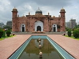
Ahsan Manzil Palace Museum
A majestic place, it was once home to the Nawab of Dhaka
, and houses 23 galleries displaying portraits, furniture and household articles.
 Jatiyo Smriti Soudho
or National Martyrs' Memorial is a monument in Bangladesh
. It is the symbol of the valour and the sacrifice of the martyrs of the Bangladesh Liberation War
of 1971, which brought the independence of Bangladesh from Pakistani rule. The monument is located in Savar
, about 35 Kilometres north-west of the capital, Dhaka
.
Districts of Bangladesh
The divisions of Bangladesh are divided into 64 districts, or zila . The districts are further subdivided into 493 sub-districts, or upazila ....
located in central Bangladesh
Bangladesh
Bangladesh , officially the People's Republic of Bangladesh is a sovereign state located in South Asia. It is bordered by India on all sides except for a small border with Burma to the far southeast and by the Bay of Bengal to the south...
, and is the densest district in the nation. It is a part of the Dhaka Division. Dhaka
Dhaka
Dhaka is the capital of Bangladesh and the principal city of Dhaka Division. Dhaka is a megacity and one of the major cities of South Asia. Located on the banks of the Buriganga River, Dhaka, along with its metropolitan area, had a population of over 15 million in 2010, making it the largest city...
, the capital of Bangladesh, rests on the eastern banks of the Buriganga River
Buriganga River
The Buriganga River is the main river flowing beside Dhaka city, capital of Bangladesh. The average depth is and maximum depth is .-History:...
which flows from the Turag
Turag River
The Turag River is the upper tributary of the Buriganga, a major river in Bangladesh. The Turag originates from the Bangshi River, the latter an important tributary of the Dhaleshwari River, flows through Gazipur and joins the Buriganga at Mirpur in Dhaka District...
to the south of the district. While Dhaka
Dhaka
Dhaka is the capital of Bangladesh and the principal city of Dhaka Division. Dhaka is a megacity and one of the major cities of South Asia. Located on the banks of the Buriganga River, Dhaka, along with its metropolitan area, had a population of over 15 million in 2010, making it the largest city...
(city) occupies only about a fifth of the area of Dhaka district, it is the economic, political and cultural centre of the district and the country as a whole.
Geography
Dhaka District shares borders with GazipurGazipur District
Gazipur District is a district of Dhaka Division, it has an area of 1741.53 km2 and is bounded by Mymensingh and Kishoreganj districts on the north, Dhaka, Narayanganj and Narsingdi districts on the south, Narsingdi on the east, Dhaka and Tangail districts on the west. Annual average...
and Tangail
Tangail District
Tangail is a district in central region of Bangladesh. It is a part of the Dhaka division. The population of Tangail zilla is about 3.2 million and its surface area is 3,414.39 km². The main town of Tangail District is the district town Tangail...
to the north, Munshiganj
Munshiganj District
Munshiganj also historically known as Bikrampur is a district in central Bangladesh. It is a part of the Dhaka Division and borders Dhaka District.-Geography:...
and Rajbari
Rajbari District
The district of Rajbari consists 3629 mosques, 18 temples and nine churches.-See also:*Districts of Bangladesh*Dhaka Division...
to the south, Narayanganj
Narayanganj District
The district of Narayanganj consists 3078 mosques, 269 temples, ten churches and four Buddhist temples.-Places of interest:The ancient city of Sonargaon was the capital of Isa Khan, a medieval ruler of Bengal. Sonargaon is also famous for producing muslin, a delicate and fine cloth made from cotton...
to the east and Manikganj
Manikganj District
The district of Manikganj consists 3575 mosques, 160 temples, 10 churches, five Buddhist temples and a pagoda.-Literacy and education:Literacy and educational institutions Average literacy 26.9%; male 33.7%, female 20.1%...
to the west. Main rivers flowing through this district are Padma
Padma River
The Padma is a major trans-boundary river in Bangladesh. It is the main distributary of the Ganges , which originates in the Himalayas. The Padma enters Bangladesh from India near Chapai Nababganj...
, Kaliganga
Dhaleshwari River
The Dhaleshwari River is a 160-km-long distributary of the Jamuna River in central Bangladesh. It starts off the Jamuna near the northwestern tip of Tangail District. After that it divides into two branches: the north branch retains the name Dhaleshwari and merges with the other branch, the...
, Dhaleshwari
Dhaleshwari River
The Dhaleshwari River is a 160-km-long distributary of the Jamuna River in central Bangladesh. It starts off the Jamuna near the northwestern tip of Tangail District. After that it divides into two branches: the north branch retains the name Dhaleshwari and merges with the other branch, the...
, Ichamati
Ichamati River
Ichamati River , is a trans-boundary river which flows through India and Bangladesh and also forms the boundary between the two countries. The river is facing the problem of siltation leading to thin flow of water in the dry season and floods in the rainy season...
, Shitalakshya
Shitalakshya River
Shitalakshya River is a distributary of the Brahmaputra. In its initial stages it flows in a southwest direction and then east of the city of Narayanganj in central Bangladesh until it merges with the Dhaleswari near Kalagachhiya. A portion of its upper course is known as Banar River...
, Buriganga
Buriganga River
The Buriganga River is the main river flowing beside Dhaka city, capital of Bangladesh. The average depth is and maximum depth is .-History:...
and numerous smaller rivers including Bangshi, Turag, Balu, Elamjani, Alam, Bherujkha, Ramkrishnadi, Elisamari, Tulsikhali. Major lakes ("beels") include Belai, Saldaher, Labandaher, Churain, Damsharan and Kiranjir Beel. Annual average temperature of the district is maximum 34.5°C, minimum 11.5°C; average annual rainfall 1931mm. The population of the division reached 11,875,000 people as of Census 2011 preliminary figures, as with all past Censuses, numbers will be revised higher once more data comes in.
Subdivisions
Dhaka district consists of several thanas (literally "police station", referring to the precinct covered by a police station) under Dhaka municipal area as well as five (5) upazilas ("sub-district"). For administrative purposes, a thana and a upazila are essentially identical. The five upazilas in Dhaka district not part of the city are:- Dhamrai UpazilaDhamrai UpazilaDhamrai is an Upazila of Dhaka District in the Division of Dhaka, Bangladesh.-Geography:Dhamrai is located at . It has 57297 units of household. The total area 307.4 km².-Demographics:...
(ধামরাই উপজেলা) - Dohar UpazilaDohar UpazilaDohar is an Upazila of Dhaka District in the Division of Dhaka, Bangladesh. The Upazilla is situated in the southern most part of Dhaka District. The mighty river of Padma borders the southern part of the upazilla.-Geography:Dohar is located at...
(দোহার উপজেলা) - Keraniganj UpazilaKeraniganj UpazilaKeraniganj is an Upazila of Dhaka District in the Division of Dhaka, Bangladesh.-Geography:Keraniganj is located at . Keraniganj stands on the southwest side of Dhaka City on the bank of the river Buriganga...
(কেরানীগঞ্জ উপজেলা) - Nawabganj UpazilaNawabganj Upazila, DhakaNawabganj is an Upazila of Dhaka District in the Division of Dhaka, Bangladesh.-Geography:Nawabganj is located at . It has 47411 units of house hold and total area 244.81 km².-Demographics:...
(নবাবগঞ্জ উপজেলা) - Savar UpazilaSavar UpazilaSavar is an Upazila of Dhaka District in the Division of Dhaka, Bangladesh. It is located at a distance of about 24 km to the northwest of Dhaka city. Savar is mostly famous for Jatiyo Smriti Soudho, the National Monument for the Martyrs of the Liberation War of Bangladesh.-Geography:Savar is...
(সাভার উপজেলা)
Dhaka (city)
Dhaka
Dhaka is the capital of Bangladesh and the principal city of Dhaka Division. Dhaka is a megacity and one of the major cities of South Asia. Located on the banks of the Buriganga River, Dhaka, along with its metropolitan area, had a population of over 15 million in 2010, making it the largest city...
has twenty-two thanas under its jurisdiction. They are:
- BaddaBadda ThanaBadda is a Thana of Dhaka District in the Division of Dhaka, Bangladesh.-Geography:Badda is located at . Its total area is 16.78 km².-Demographics:...
(বাড্ডা থানা) - Biman Bandar (বিমান বন্দর থানা)
- CantonmentCantonment ThanaCantonment , popularly called Dhaka Cantonment, is a Thana of Dhaka District in the Division of Dhaka, Bangladesh. It is the seat of the Army Headquarter, Naval Headquarter and the Air Force Headquarter, as well as other important military establishments....
(ক্যান্টনমেন্ট থানা) - DhanmondiDhanmondi ThanaDhanmondi is one of the most crowded planned areas in Dhaka city. Its origins can be traced back to the late 1950s, beginning as an affluent residential area, and over the decades evolving into a miniature city, where one can find everything from hospitals to malls, schools, banks, offices and...
(ধানমন্ডি থানা) - DemraDemra ThanaDemra is a Thana of Dhaka District in the Division of Dhaka, Bangladesh.-Geography:Demra is located at . It has 102757 units of house hold and total area 47.35 km².-Demographics:...
(ডেমরা থানা) - KotwaliDhaka Kotwali ThanaDhaka Kotwali is a Thana of Dhaka District in the Division of Dhaka, Bangladesh.-Geography:Dhaka Kotwali is located at . It has 31992 units of house hold and total area 2.07 km².-Demographics:...
(কোতয়ালী থানা) - DhanmondiDhanmondi ThanaDhanmondi is one of the most crowded planned areas in Dhaka city. Its origins can be traced back to the late 1950s, beginning as an affluent residential area, and over the decades evolving into a miniature city, where one can find everything from hospitals to malls, schools, banks, offices and...
(ধানমন্ডি থানা) - GulshanGulshan ThanaGulshan is an affluent neighborhood of Dhaka, the capital of Bangladesh. It is home to Bangladesh's wealthiest residents, including the billionaire Musa Bin Shamsher.- History :...
(গুলশান থানা) - HazaribaghHazaribagh ThanaHazaribagh is a Thana of Dhaka District in the Division of Dhaka, Bangladesh.Bangladesh College of Leather Technology is situated at Hazaribagh.-Environment:...
(হাজারীবাগ থানা) - KafrulKafrul ThanaKafrul is a Thana of Dhaka District in the Division of Dhaka, Bangladesh.- Geography :Kafrul is located at . Its total area is 17.8 km².- Demographics :...
(কাফরুল থানা) - Kamringir Char (কামরাঙ্গীর চর থানা)
- KhilgaonKhilgaon ThanaKhilgaon is a Thana of Dhaka District in the Division of Dhaka, Bangladesh.-Geography:Khilgaon is located at . Its total area is 14.02 km².-Demographics:...
(খিলগাঁও থানা) - LalbaghLalbagh ThanaLalbagh is a Thana of Dhaka District in the Division of Dhaka, Bangladesh.-Geography:Lalbagh is located at . It has 71475 units of house hold and total area 9.14 km²....
(লালবাগ থানা) - MirpurMirpur ThanaMirpur is a thana of Dhaka city, Bangladesh. It is bounded by Pallabi Thana to the north, Mohammadpur Thana to the south, Kafrul to the east - to the west it is bounded by Savar Upazila.-Geography:Mirpur is located at...
(মিরপুর থানা) - MohammadpurMohammadpur ThanaMohammadpur is a Thana of Dhaka District in the Division of Dhaka, Bangladesh. Though initially Mohammadpur has grown as a residential area, nowadays many commercial places can be found here. The area has become more crowded than it was before...
(মোহাম্মদপুর থানা) - MotijheelMotijheel ThanaMotijheel is a Thana of Dhaka District in the Division of Dhaka, Bangladesh.-Geography:Motijheel is located at . It has 36059 units of house hold and total area 4.69 km².-Demographics:...
(মতিঝিল থানা) - PallabiPallabi ThanaPallabi is a Thana of Dhaka District in the Division of Dhaka, Bangladesh.- Demographics :This Pallabi has a population of 364000. Males constitute are 52.74% of the population, and females 47.26%...
(পল্লবী থানা) - RamnaRamna ThanaRamna is a Thana of Dhaka District in the Division of Dhaka, Bangladesh.-Demographics:As of the 1991 Bangladesh census, Ramna has a population of 195,167. Males constitute are 58.32% of the population, and females 41.68%. The upazila's population of those aged 18 and higher is 127,049...
(রমনা থানা) - SabujbaghSabujbagh ThanaSabujbagh is a Thana of Dhaka District in the Division of Dhaka, Bangladesh.-Geography:Sabujbagh is located at . It has 65517 units of house hold and total area 18.18 km².-Demographics:...
(সবুজবাগ থানা) - Shyampur (শ্যামপুর থানা)
- SutrapurSutrapur ThanaSutrapur is a Thana of Dhaka District in the Division of Dhaka, Bangladesh.-Geography:Sutrapur is located at . It has 49,286 households and total area 4.38 km².-Demographics:...
(সুত্রাপুর থানা) - TejgaonTejgaon ThanaTejgaon is a Thana of Dhaka District in the Division of Dhaka, Bangladesh. It is a large area in the centre of Dhaka, the capital of Bangladesh. This is an important area of Dhaka city as prime minister's office is located here. It is bounded by Mohakhali to the north, Old Airport Road to the east...
(তেজগাঁও থানা) - UttaraUttara ThanaUttara is a Thana of Dhaka, the capital of Bangladesh. The name derives from the Bengali word "ut'tar" meaning "north". It lies on the road to Gazipur, and adjoins Shahjalal International Airport....
(উত্তরা থানা)
The municipal area of Dhaka city is under the jurisdiction of the Dhaka City Corporation
Dhaka City Corporation
Dhaka City Corporation is the former self-governing corporation that is associated with the task of running the affairs of the city of Dhaka. The incorporated area is divided into several wards. Each ward has an elected ward commissioner. The mayor of the city is elected by popular vote every five...
; for administrative purposes, the municipal area is divided into 90 wards.
History
Savar Upazila
Savar is an Upazila of Dhaka District in the Division of Dhaka, Bangladesh. It is located at a distance of about 24 km to the northwest of Dhaka city. Savar is mostly famous for Jatiyo Smriti Soudho, the National Monument for the Martyrs of the Liberation War of Bangladesh.-Geography:Savar is...
was the capital of the Sanbagh Kingdom during seventh and eighth century. The city area of Dhaka was ruled by the Buddhist
Buddhism
Buddhism is a religion and philosophy encompassing a variety of traditions, beliefs and practices, largely based on teachings attributed to Siddhartha Gautama, commonly known as the Buddha . The Buddha lived and taught in the northeastern Indian subcontinent some time between the 6th and 4th...
kingdom of Kamarupa
Kamarupa (History)
Kamarupa, also called Pragjyotisha, was the first historical kingdom in Assam that existed between 350 and 1140 CE i.e for almost 800 years. Ruled by three dynasties from their capitals in present-day Guwahati and Tezpur, it covered the entire Brahmaputra river valley and, at times, North Bengal...
and the Pala Empire
Pala Empire
The Pāla Empire was one of the major middle kingdoms of India existed from 750–1174 CE. It was ruled by a Buddhist dynasty from Bengal in the eastern region of the Indian subcontinent, all the rulers bearing names ending with the suffix Pala , which means protector. The Palas were often described...
before passing to the control of the Hindu
Hindu
Hindu refers to an identity associated with the philosophical, religious and cultural systems that are indigenous to the Indian subcontinent. As used in the Constitution of India, the word "Hindu" is also attributed to all persons professing any Indian religion...
Sena dynasty
Sena dynasty
The Sena Empire was a Hindu dynasty that ruled from Bengal through the 11th and 12th centuries. At its peak the empire covered much of the north-eastern region in the Indian Subcontinent. They were called Brahma-Kshatriyas, as evidenced through their surname, which is derived from the Sanskrit,...
in the 9th century. Many believe that the name of the city was derived after the establishment of the Goddess Dhakeshwari's temple by Ballal Sena
Ballal Sena
Ballal Sen was the second ruler of the Sen dynasty of Bengal. Son and successor of Vijay Sen, Ballal Sen is known from the extant Kuljigranthas to have introduced social reforms in Bengal, especially the system of Kulinism.-See also:* Prithvi Raj Chauhan* List of rulers of Bengal* History of...
in the 12th century. Dhaka and its surrounding area was identified as Bengalla around that period. The town itself consisted of a few market centers like Lakshmi Bazar, Shankhari Bazar, Tanti Bazar, Patuatuli, Kumartuli, Bania Nagar and Goal Nagar. After the Sena dynasty, Dhaka was successively ruled by the Turkish
Turkic peoples
The Turkic peoples are peoples residing in northern, central and western Asia, southern Siberia and northwestern China and parts of eastern Europe. They speak languages belonging to the Turkic language family. They share, to varying degrees, certain cultural traits and historical backgrounds...
and Afghan
Pashtun people
Pashtuns or Pathans , also known as ethnic Afghans , are an Eastern Iranic ethnic group with populations primarily between the Hindu Kush mountains in Afghanistan and the Indus River in Pakistan...
governors descending from the Delhi Sultanate
Delhi Sultanate
The Delhi Sultanate is a term used to cover five short-lived, Delhi based kingdoms or sultanates, of Turkic origin in medieval India. The sultanates ruled from Delhi between 1206 and 1526, when the last was replaced by the Mughal dynasty...
before the arrival of the Mughals in 1608.
The development of townships and a significant growth in population came as the city was proclaimed the capital of Bengal under Mughal
Mughal Empire
The Mughal Empire , or Mogul Empire in traditional English usage, was an imperial power from the Indian Subcontinent. The Mughal emperors were descendants of the Timurids...
rule in 1608. During Mughal rule the areas currently under Dhaka district was famous for its textile products — especially the Muslin
Muslin
Muslin |sewing patterns]], such as for clothing, curtains, or upholstery. Because air moves easily through muslin, muslin clothing is suitable for hot, dry climates.- Etymology and history :...
. Mughal subahdar
Subahdar
Subahdar was one of the designations of a governor of a Subah during the Mughal era of India who was alternately designated as Sahib-i-Subah or Nazim. The word, Subahdar is of Persian origin...
Islam Khan
Islam Khan
Islam Khan may refer to:*Islam Khan I - also known as Islam Khan Chisti *Islam Khan II - also known as Islam Khan Mashhadi *Islam Khan III - also known as Islam Khan Badakhshi...
was the first administrator of the city. Khan named the town "Jahangir Nagar" (City of Jahangir) in honour of the Mughal emperor Jahangir
Jahangir
Jahangir was the ruler of the Mughal Empire from 1605 until his death. The name Jahangir is from Persian جهانگیر,meaning "Conqueror of the World"...
, although this name was dropped soon after Jahangir's death. The main expansion of the city took place under Mughal general Shaista Khan
Shaista Khan
Mirza Abu Talib, better known by his title Shaista Khan , was a Subahdar and general in the army of the Mughal Empire. A maternal uncle to Emperor Aurangzeb, he served as the Mughal governor of Bengal from 1664 to 1688, and was a key figure during the rule of his nephew, the emperor...
. The city then measured 19 by 13 kilometres (12 by 8 mi), with a population of nearly a million people. The city passed to the control of the British East India Company
British East India Company
The East India Company was an early English joint-stock company that was formed initially for pursuing trade with the East Indies, but that ended up trading mainly with the Indian subcontinent and China...
in 1757 after the Battle of Plassey
Battle of Plassey
The Battle of Plassey , 23 June 1757, was a decisive British East India Company victory over the Nawab of Bengal and his French allies, establishing Company rule in South Asia which expanded over much of the Indies for the next hundred years...
and eventually to the Crown
The Crown
The Crown is a corporation sole that in the Commonwealth realms and any provincial or state sub-divisions thereof represents the legal embodiment of governance, whether executive, legislative, or judicial...
, British Empire
British Empire
The British Empire comprised the dominions, colonies, protectorates, mandates and other territories ruled or administered by the United Kingdom. It originated with the overseas colonies and trading posts established by England in the late 16th and early 17th centuries. At its height, it was the...
, in 1765 at the Battle of Buxer. The city's population shrank dramatically during this period as the prominence of Kolkata
Kolkata
Kolkata , formerly known as Calcutta, is the capital of the Indian state of West Bengal. Located on the east bank of the Hooghly River, it was the commercial capital of East India...
rose, but substantive development and modernisation eventually followed. A modern civic water supply system was introduced in 1874 and electricity supply launched in 1878. The Dhaka Cantonment
Dhaka Cantonment
Dhaka Cantonment is a cantonment located in the northern part of Dhaka, Bangladesh. The headquarters of Bangladesh Army, Navy and Air Force are situated within this cantonment...
was established near the city, serving as a base for British and Indian soldiers.
Partition of Bengal (1905)
The decision of the Partition of Bengal was announced on 19 July 1905 by the Viceroy of India, Lord Curzon. The partition took effect on 16 October 1905...
in 1905, Dhaka was declared to be the capital of the newly established state of Eastern Bengal and Assam, but Bengal was reunited in 1911. The rural areas under present Dhaka district, especially Dohar Upazila
Dohar Upazila
Dohar is an Upazila of Dhaka District in the Division of Dhaka, Bangladesh. The Upazilla is situated in the southern most part of Dhaka District. The mighty river of Padma borders the southern part of the upazilla.-Geography:Dohar is located at...
were used for the production of indigo
Indigo
Indigo is a color named after the purple dye derived from the plant Indigofera tinctoria and related species. The color is placed on the electromagnetic spectrum between about 420 and 450 nm in wavelength, placing it between blue and violet...
.
During 1920s the people of Dhaka District were influenced by the Non Co-operation Movement led by Mahatma Gandhi
Mahatma Gandhi
Mohandas Karamchand Gandhi , pronounced . 2 October 1869 – 30 January 1948) was the pre-eminent political and ideological leader of India during the Indian independence movement...
. Avay Ashram was established at Dohar in 1922-23 following the ideals of Gandhi. The All India Convention of Gandhi Seba Sangha was held at village Malikandha of Dohar
Dohar Upazila
Dohar is an Upazila of Dhaka District in the Division of Dhaka, Bangladesh. The Upazilla is situated in the southern most part of Dhaka District. The mighty river of Padma borders the southern part of the upazilla.-Geography:Dohar is located at...
in 1940. On this occasion Gandhi came here and stayed for two days.
Following the partition of Bengal in (1947) appending the partition of British India in 1947, Dhaka became the capital of East Bengal
East Bengal
East Bengal was the name used during two periods in the 20th century for a territory that roughly corresponded to the modern state of Bangladesh. Both instances involved a violent partition of Bengal....
as a part of the new Muslim state
Islamism
Islamism also , lit., "Political Islam" is set of ideologies holding that Islam is not only a religion but also a political system. Islamism is a controversial term, and definitions of it sometimes vary...
of Pakistan
Pakistan
Pakistan , officially the Islamic Republic of Pakistan is a sovereign state in South Asia. It has a coastline along the Arabian Sea and the Gulf of Oman in the south and is bordered by Afghanistan and Iran in the west, India in the east and China in the far northeast. In the north, Tajikistan...
, while western part of Bengal with a majority Hindu population had become a part of the new and independent India, designated as West Bengal
West Bengal
West Bengal is a state in the eastern region of India and is the nation's fourth-most populous. It is also the seventh-most populous sub-national entity in the world, with over 91 million inhabitants. A major agricultural producer, West Bengal is the sixth-largest contributor to India's GDP...
with Calcutta as state capital. Calcutta witnessed communal violence that left thousands of people dead. A large proportion of the city's Hindu
Hinduism in Bangladesh
Hinduism is the second largest religious affiliation in Bangladesh, covering more than 9.2% of the population, according to the Bangladesh Bureau of Statistics...
population departed for India
India
India , officially the Republic of India , is a country in South Asia. It is the seventh-largest country by geographical area, the second-most populous country with over 1.2 billion people, and the most populous democracy in the world...
, while the city received hundreds of thousands of Muslim
Islam in Bangladesh
Islam is the largest religion of Bangladesh, the Muslim population is approximately 148.6 million, which is the third largest Muslim population in the world, constituting 90.4% of the total population as of 2010. Religion has always been a strong part of identity, but this has varied at different...
immigrants from Calcutta, India. The city's population rose dramatically in a very short period of time, which created severe shortages and infrastructural problems. As the centre of regional politics, Dhaka saw an increasing number of political strikes and incidents of violence. The adoption of Urdu
Urdu
Urdu is a register of the Hindustani language that is identified with Muslims in South Asia. It belongs to the Indo-European family. Urdu is the national language and lingua franca of Pakistan. It is also widely spoken in some regions of India, where it is one of the 22 scheduled languages and an...
as the sole official language
Official language
An official language is a language that is given a special legal status in a particular country, state, or other jurisdiction. Typically a nation's official language will be the one used in that nation's courts, parliament and administration. However, official status can also be used to give a...
of Pakistan led to protest marches involving large crowds. Known as the language movement of 1952
Language movement
Language movement may imply any of the following:Language specific social/political movements:*The Bengali Language Movement, which is commemorated by the International Mother Language Day declared by UNESCO and Language Movement Day in Bangladesh...
, the protests resulted in police firing which killed students who were demonstrating peacefully. Throughout the 1950s and '60s, Dhaka remained a hotbed of political activity, and the demands for autonomy for the Bengali population gradually gained momentum.
The 1970 Bhola cyclone
1970 Bhola cyclone
The 1970 Bhola cyclone was a devastating tropical cyclone that struck East Pakistan and India's West Bengal on November 12, 1970. It was the deadliest tropical cyclone ever recorded, and one of the deadliest natural disasters in modern times...
devastated much of the region, killing an estimated 500,000 people. More than half the city of Dhaka was flooded and millions of people marooned. With public anger growing against ethnic discrimination and poor cyclone relief efforts from the central government, Bengali politician Sheikh Mujibur Rahman
Sheikh Mujibur Rahman
Sheikh Mujibur Rahman was a Bengali nationalist politician and the founder of Bangladesh. He headed the Awami League, served as the first President of Bangladesh and later became its Prime Minister. He headed the Awami League, served as the first President of Bangladesh and later became its...
held a nationalist rally on March 7, 1971 at the Race Course Ground
Suhrawardy Udyan
Suhrawardy Udyan formerly known as Ramna Racecourse ground is a national memorial located in Dhaka, Bangladesh. Once known as ‘‘Bagh-e-Badshahi’’ during the Mughal rule, it is named after Huseyn Shaheed Suhrawardy. Originally it served as the military club of the British soldiers stationed in Dhaka...
. An estimated one million people attended the gathering, leading to Ziaur Rahman
Ziaur Rahman
President Ziaur Rahman, Bir Uttam, was a Bangladeshi politician and general, who read the declaration of Independence of Bangladesh on March 26, 1971 on behalf of Sheikh Mujibur Rahman. He later became the seventh President of Bangladesh from 1977 until 1981...
's March 26 declaration of Bangladesh's independence. In response, the Pakistan Army
Pakistan Army
The Pakistan Army is the branch of the Pakistani Armed Forces responsible for land-based military operations. The Pakistan Army came into existence after the Partition of India and the resulting independence of Pakistan in 1947. It is currently headed by General Ashfaq Parvez Kayani. The Pakistan...
launched Operation Searchlight
Operation Searchlight
Operation Searchlight was a planned military operation carried out by the Pakistan Army to curb the Bengali nationalist movement in the erstwhile East Pakistan in March 1971. Ordered by the central government in West Pakistan, this was seen as the sequel to "Operation Blitz" which had been...
, which led to the arrests, torture and killing of hundreds of thousands of people, mainly Hindus and Bengali
Bengali people
The Bengali people are an ethnic community native to the historic region of Bengal in South Asia. They speak Bengali , which is an Indo-Aryan language of the eastern Indian subcontinent, evolved from the Magadhi Prakrit and Sanskrit languages. In their native language, they are referred to as বাঙালী...
intellectuals.
During the Bangladesh Liberation War
Bangladesh Liberation War
The Bangladesh Liberation War was an armed conflict pitting East Pakistan and India against West Pakistan. The war resulted in the secession of East Pakistan, which became the independent nation of Bangladesh....
the Pakistan
Pakistan
Pakistan , officially the Islamic Republic of Pakistan is a sovereign state in South Asia. It has a coastline along the Arabian Sea and the Gulf of Oman in the south and is bordered by Afghanistan and Iran in the west, India in the east and China in the far northeast. In the north, Tajikistan...
army arrested fourteen Muktijoddhas from Dhamrai
Dhamrai Upazila
Dhamrai is an Upazila of Dhaka District in the Division of Dhaka, Bangladesh.-Geography:Dhamrai is located at . It has 57297 units of household. The total area 307.4 km².-Demographics:...
Bazar and brutally killed all of them at a place near Kalampur Bazar. A mass grave created during the war still exists in the western side of Kalampur Bazar. The Pak army also burnt down many houses in Konakhola, Basta, Brahmankirtha, Goalkhali and Khagail Kholamora villages of Keraniganj Upazila
Keraniganj Upazila
Keraniganj is an Upazila of Dhaka District in the Division of Dhaka, Bangladesh.-Geography:Keraniganj is located at . Keraniganj stands on the southwest side of Dhaka City on the bank of the river Buriganga...
.
The fall of Dhaka city to the allied forces led by Jagjit Singh Aurora
Jagjit Singh Aurora
Lieutenant General Jagjit Singh Aurora was the General Officer Commanding-in-Chief of the Eastern Command of the Indian Army during the Indo-Pakistani War of 1971...
on December 16 marked the surrender of Pakistan army. The post-independence period has seen a rapid and massive growth of the city population, attracting migrant workers from rural areas across Bangladesh. A real estate boom has followed the expansion of city limits and the development of new settlements such as Gulshan, Banani and Motijheel
Motijheel
Motijheel is an administrative division of Dhaka city, the capital of Bangladesh. It is situated at the heart of the city . Motijheel is the major business and commercial hub of Dhaka city and has more offices and business institutions than any other part of the city...
.
Religion
The district of Dhaka consists 12000 mosques, 3012 temples, 530 churches, 174 Buddhist temples, three pagodas and a synagogue. For many times, Islam is the majority population in Dhaka, but they have 1300 mosques, but they gained 10700 more mosques in this districts. It is called the City of Mosques.Economy
Many skilled workers are employed in the businesses and industries located in the Dhaka metropolitan area. The city has historically attracted a large number of migrant workers. Hawkers
Hawker centre
A hawker centre or cooked food centre is the name given to open-air complexes in Hong Kong, Malaysia, Singapore and Riau Islands housing many stalls that sell a variety of inexpensive food...
, peddlers, small shops, rickshaws transport, roadside vendors and stalls employ a large segment of the population — rickshaw-drivers alone number as many as 400,000. Half the workforce is employed in household and unorganised labour, while about 800,000 work in the textile
Textile
A textile or cloth is a flexible woven material consisting of a network of natural or artificial fibres often referred to as thread or yarn. Yarn is produced by spinning raw fibres of wool, flax, cotton, or other material to produce long strands...
industry. Even so, unemployment remains high at 23%. According to CityMayors Statisticshttp://www.citymayors.com/statistics/richest-cities-2005.html, Dhaka's GDP registered at $52 billion in 2005 with an annual growth rate of 6.1%. Its estimated GDP in the year 2020 is $126 billion. The annual per capita income of Dhaka is estimated at $550, although a large segment of the population lives below the poverty line, with many surviving on less than $3 a day.
The main business districts of the city include Motijheel
Motijheel
Motijheel is an administrative division of Dhaka city, the capital of Bangladesh. It is situated at the heart of the city . Motijheel is the major business and commercial hub of Dhaka city and has more offices and business institutions than any other part of the city...
, Panthapath and Gulshan. Bashundhara City
Bashundhara City
Bashundhara City is a shopping mall located in Dhaka, Bangladesh with a rotunda architecture. . Opened to the public on 6 August 2004, the mall is located at Panthapath, near Karwan Bazar, in Dhaka city...
is a recently developed economic area that houses many high-tech industries and corporations and a shopping mall that is one of the largest in Southeast Asia, frequented daily by more than 25,000 people. The Export Processing Zone in Dhaka was set up to encourage the export of garments, textiles and other goods. The EPZ is home to 80 factories, which employ mostly women. The Dhaka Stock Exchange
Dhaka Stock Exchange
Dhaka Stock Exchange is the main stock exchange of Bangladesh. It is located in Motijheel at the heart of the Dhaka city. It was incorporated in 1954. Dhaka stock exchange is the first stock exchange of the country...
is based in the city, as are most of the large companies and banks of Bangladesh, including the Bangladesh Bank
Bangladesh Bank
Bangladesh Bank is the Central bank of Bangladesh and is a member of the Asian Clearing Union.-History:After the liberation war, and the eventual independence of Bangladesh, the Government of Bangladesh reorganized the Dhaka branch of the State Bank of Pakistan as the central bank of the country,...
, HSBC
HSBC
HSBC Holdings plc is a global banking and financial services company headquartered in Canary Wharf, London, United Kingdom. it is the world's second-largest banking and financial services group and second-largest public company according to a composite measure by Forbes magazine...
, Citibank
Citibank
Citibank, a major international bank, is the consumer banking arm of financial services giant Citigroup. Citibank was founded in 1812 as the City Bank of New York, later First National City Bank of New York...
and the Grameen Bank
Grameen Bank
The Grameen Bank is a microfinance organization and community development bank started in Bangladesh that makes small loans to the impoverished without requiring collateral...
. Urban developments have sparked a widespread construction boom, causing new high-rise buildings and skyscraper
Skyscraper
A skyscraper is a tall, continuously habitable building of many stories, often designed for office and commercial use. There is no official definition or height above which a building may be classified as a skyscraper...
s to change the city landscape. Growth has been especially strong in the finance, banking, manufacturing, telecommunications and services sectors, while tourism
Tourism
Tourism is travel for recreational, leisure or business purposes. The World Tourism Organization defines tourists as people "traveling to and staying in places outside their usual environment for not more than one consecutive year for leisure, business and other purposes".Tourism has become a...
, hotels and restaurants continue as important elements of the Dhaka economy.
Places of interest
The historic city of DhakaDhaka
Dhaka is the capital of Bangladesh and the principal city of Dhaka Division. Dhaka is a megacity and one of the major cities of South Asia. Located on the banks of the Buriganga River, Dhaka, along with its metropolitan area, had a population of over 15 million in 2010, making it the largest city...
is the capital of Bangladesh
Bangladesh
Bangladesh , officially the People's Republic of Bangladesh is a sovereign state located in South Asia. It is bordered by India on all sides except for a small border with Burma to the far southeast and by the Bay of Bengal to the south...
and lies on the banks of the Buriganga River in the central area of Bangladesh. The old town of Dhaka, south of the city centre, is the site of most of the tourist attractions, including the Lalbagh Fort, the Stat Mosque, and the Ahsan Manzil
Ahsan Manzil
Ahsan Manzil was the official residential palace and seat of the Dhaka Nawab Family. This magnificent building is situated at Kumartoli along the banks of the Buriganga River in Bangladesh. The construction of this palace was started in the year 1859 and was completed in 1869. It is constructed in...
Palace Museum.
The city of Dhaka was predominantly a city of the Mughals, whose governors and viceroys built several palace, mosques and katrias. Dhaka's finest specimen of this time is the Aurangabad Fort, commonly known as Lalbaght Fort, incomplete but well worth for visit. Also in this area of Dhaka is the spectacular Ahsan Manzil Plance Museum, the Bara Katra
Bara Katra
The Bara Katra is a historical and architectural monument located in the city of Dhaka, Bangladesh. It is a palatial building dating to the reign of the Mughal dynasty in the Bengal region...
, the Cotta Katra and several mosques of note.
The old European quarter lies just north of Dhaka's old town, which houses the presidential place and the National Museum, Dhaka's commercial and diplomatic regions are north-east of this zone. Dhaka Zoo and the Botanical Gardens are a short taxi ride into the suburbs.
Once famed for its Muslin
Muslin
Muslin |sewing patterns]], such as for clothing, curtains, or upholstery. Because air moves easily through muslin, muslin clothing is suitable for hot, dry climates.- Etymology and history :...
, Dhaka is now renowned for pink pearls and a rich tradition of handicrafts. Shoppers can find lower prices of gold
Gold
Gold is a chemical element with the symbol Au and an atomic number of 79. Gold is a dense, soft, shiny, malleable and ductile metal. Pure gold has a bright yellow color and luster traditionally considered attractive, which it maintains without oxidizing in air or water. Chemically, gold is a...
and silver
Silver
Silver is a metallic chemical element with the chemical symbol Ag and atomic number 47. A soft, white, lustrous transition metal, it has the highest electrical conductivity of any element and the highest thermal conductivity of any metal...
products, and the Dhaka shopping areas of New market and Elephant road and Dhanmondi are good for shopping.
The Botanical garden
Botanical garden
A botanical garden The terms botanic and botanical, and garden or gardens are used more-or-less interchangeably, although the word botanic is generally reserved for the earlier, more traditional gardens. is a well-tended area displaying a wide range of plants labelled with their botanical names...
is a park at Mirpur
Mirpur Thana
Mirpur is a thana of Dhaka city, Bangladesh. It is bounded by Pallabi Thana to the north, Mohammadpur Thana to the south, Kafrul to the east - to the west it is bounded by Savar Upazila.-Geography:Mirpur is located at...
in Dhaka.It contains various species of plants.It is also a major tourist spot.
Lalbagh Fort
Built in 1678 by the Viceroy of Bengal, it contains a three-domed mosque, the tomb of Pari Bibi, the reputed daughter of Nawab Shaista Khan, the Audience Hall and the hammam of the Governor. Four Kilometres from the hotel.Ahsan Manzil Palace Museum
A majestic place, it was once home to the Nawab of Dhaka
Nawab of Dhaka
The Nawab of Dhaka was the title of the head of the Dhaka Nawab Estate, the largest and richest Muslim zamindari in Bengal. The first Nawab of Dhaka was Khwaja Alimullah who had been installed by the British Raj as head of the estate, which covered modern day Dhaka city and several of its...
, and houses 23 galleries displaying portraits, furniture and household articles.
Jatiyo Smriti Soudho
Jatiyo Smriti Soudho
Jatiyo Sriti Soudho or National Martyrs' Memorial is a monument in Bangladesh. It is the symbol of the valour and the sacrifice of those killed in the Bangladesh Liberation War of 1971, which brought the independence of Bangladesh from Pakistani rule. The monument is located in Savar, about...
or National Martyrs' Memorial is a monument in Bangladesh
Bangladesh
Bangladesh , officially the People's Republic of Bangladesh is a sovereign state located in South Asia. It is bordered by India on all sides except for a small border with Burma to the far southeast and by the Bay of Bengal to the south...
. It is the symbol of the valour and the sacrifice of the martyrs of the Bangladesh Liberation War
Bangladesh Liberation War
The Bangladesh Liberation War was an armed conflict pitting East Pakistan and India against West Pakistan. The war resulted in the secession of East Pakistan, which became the independent nation of Bangladesh....
of 1971, which brought the independence of Bangladesh from Pakistani rule. The monument is located in Savar
Savar Upazila
Savar is an Upazila of Dhaka District in the Division of Dhaka, Bangladesh. It is located at a distance of about 24 km to the northwest of Dhaka city. Savar is mostly famous for Jatiyo Smriti Soudho, the National Monument for the Martyrs of the Liberation War of Bangladesh.-Geography:Savar is...
, about 35 Kilometres north-west of the capital, Dhaka
Dhaka
Dhaka is the capital of Bangladesh and the principal city of Dhaka Division. Dhaka is a megacity and one of the major cities of South Asia. Located on the banks of the Buriganga River, Dhaka, along with its metropolitan area, had a population of over 15 million in 2010, making it the largest city...
.