

Cityscape of Louisville, Kentucky
Encyclopedia

Louisville, Kentucky
Louisville is the largest city in the U.S. state of Kentucky, and the county seat of Jefferson County. Since 2003, the city's borders have been coterminous with those of the county because of a city-county merger. The city's population at the 2010 census was 741,096...
is home to numerous structures that are noteworthy due to their architectural characteristics or historic associations, the most noteworthy being the Old Louisville
Old Louisville
Old Louisville is a historic district and neighborhood in central Louisville, Kentucky, USA. It is the third largest such district in the United States, and the largest preservation district featuring almost entirely Victorian architecture...
neighborhood, the third largest historic preservation
Historic preservation
Historic preservation is an endeavor that seeks to preserve, conserve and protect buildings, objects, landscapes or other artifacts of historical significance...
district in the United States
United States
The United States of America is a federal constitutional republic comprising fifty states and a federal district...
. The city also boasts the postmodern
Postmodern architecture
Postmodern architecture began as an international style the first examples of which are generally cited as being from the 1950s, but did not become a movement until the late 1970s and continues to influence present-day architecture...
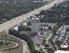
Humana Building
Humana Building
The Humana Building, also known as the Humana Tower, is a skyscraper in downtown Louisville, Kentucky, located at 500 West Main Street. The 27-story structure is headquarters of the Humana Corporation and known for its postmodern architecture. It was designed by Michael Graves...
and an expanding Waterfront Park
Louisville Waterfront Park
Louisville Waterfront Park is a municipal park adjacent to the downtown area of Louisville, Kentucky and the Ohio River. Specifically, it is adjacent to Louisville's wharf and Riverfront Plaza/Belvedere, which are situated to the west of the park....
which has served to remove the former industrial appearance of the riverfront.
Business districts
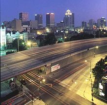
The downtown business districtDowntown Louisville
Downtown Louisville is the largest central business district in the Commonwealth of Kentucky and the urban hub of the Louisville, Kentucky Metropolitan Area. Its boundaries are the Ohio River to the north, Hancock Street to the east, York and Jacob Streets to the south, and 9th Street to the west...
of Louisville is located immediately south of the Ohio River
Ohio River
The Ohio River is the largest tributary, by volume, of the Mississippi River. At the confluence, the Ohio is even bigger than the Mississippi and, thus, is hydrologically the main stream of the whole river system, including the Allegheny River further upstream...
, and southeast of the Falls of the Ohio
Falls of the Ohio National Wildlife Conservation Area
The Falls of the Ohio National Wildlife Conservation Area is a national, bi-state area on the Ohio River near Louisville, Kentucky in the United States, administered by the U.S. Army Corps of Engineers. Federal status was awarded in 1981.- Overview :...
. The airport
Louisville International Airport
Louisville International Airport is a joint civil-military public airport centrally located in the city of Louisville in Jefferson County, Kentucky, USA. The airport covers 1,200 acres and has three runways. Its IATA airport code SDF is based on the airport's former name, Standiford Field...
is located approximately 6.5 miles (10 km) south of the downtown area, and easily connected to most parts of the city by three Interstate Highways, maximizing its accessibility. The largest industrial
Industry
Industry refers to the production of an economic good or service within an economy.-Industrial sectors:There are four key industrial economic sectors: the primary sector, largely raw material extraction industries such as mining and farming; the secondary sector, involving refining, construction,...
sections of town are located to the south and west of the airport, while most of the residential areas of the city are located to the southwest, south and east of downtown.
Another major business district
Central business district
A central business district is the commercial and often geographic heart of a city. In North America this part of a city is commonly referred to as "downtown" or "city center"...
is located in the more suburban area
Suburb
The word suburb mostly refers to a residential area, either existing as part of a city or as a separate residential community within commuting distance of a city . Some suburbs have a degree of administrative autonomy, and most have lower population density than inner city neighborhoods...
east of the city on Hurstbourne Parkway. This area is considered Louisville's key edge city
Edge city
"Edge city" is an American term for a concentration of business, shopping, and entertainment outside a traditional urban area in what had recently been a residential suburb or semi-rural community...
—a relatively new concentration of business, shopping and entertainment outside a traditional urban area. Louisville also boasts a large number of park
Park
A park is a protected area, in its natural or semi-natural state, or planted, and set aside for human recreation and enjoyment, or for the protection of wildlife or natural habitats. It may consist of rocks, soil, water, flora and fauna and grass areas. Many parks are legally protected by...
s, with 122 parks covering more than 14,000 acre
Acre
The acre is a unit of area in a number of different systems, including the imperial and U.S. customary systems. The most commonly used acres today are the international acre and, in the United States, the survey acre. The most common use of the acre is to measure tracts of land.The acre is related...
s (57 km²).
Transportation infrastructure
Bridge
A bridge is a structure built to span physical obstacles such as a body of water, valley, or road, for the purpose of providing passage over the obstacle...
s crossing the Ohio River to Indiana
Indiana
Indiana is a US state, admitted to the United States as the 19th on December 11, 1816. It is located in the Midwestern United States and Great Lakes Region. With 6,483,802 residents, the state is ranked 15th in population and 16th in population density. Indiana is ranked 38th in land area and is...
: the Sherman Minton Bridge
Sherman Minton Bridge
The Sherman Minton Bridge is a double-deck through arch bridge spanning the Ohio River, carrying I-64 and US 150 over the river between Kentucky and Indiana. The bridge connects the west side of Louisville, Kentucky to downtown New Albany, Indiana.- History :...
(I-64
Interstate 64
Interstate 64 is an Interstate Highway in the Midwestern and Southeastern United States. Its western terminus is at I-70, U.S. 40, and U.S. 61 in Wentzville, Missouri. Its eastern terminus is at an interchange with I-264 and I-664 at Bowers Hill in Chesapeake, Virginia. As I-64 is concurrent with...
) in the city's West End, and the John F. Kennedy Memorial Bridge
John F. Kennedy Memorial Bridge
The John F. Kennedy Memorial Bridge is a seven-lane, single-deck cantilever bridge that carries Interstate 65 across the Ohio River, connecting Louisville, Kentucky and Jeffersonville, Indiana. The main span is and the bridge has a total length of...
(I-65
Interstate 65
Interstate 65 is a major Interstate Highway in the United States. The southern terminus is located at an intersection with Interstate 10 in Mobile, Alabama, and its northern terminus is at an interchange with Interstate 90 , U.S. Route 12, and U.S...
) and the George Rogers Clark Memorial Bridge or Second Street Bridge (US 31) in Downtown Louisville. Two more bridges are planned to be built as part of the Ohio River Bridges Project
Ohio River Bridges Project
The Ohio River Bridges Project is a controversial Louisville metropolitan area transportation project involving the reconstruction of the Kennedy Interchange , the completion of two new Ohio River bridges and the reconstruction of ramps on Interstate 65 between I-264 and downtown.One bridge will be...
by 2020. One will parallel the Kennedy Bridge and the other will extend the Indiana and Kentucky segments of I-265
Interstate 265
Interstate 265 is an Interstate Highway ringing the Louisville, Kentucky metropolitan area, which includes southern Indiana, although the Indiana and Kentucky segments remain separate at the present time. In Kentucky it only runs through Jefferson County, from Interstate 71 in northeastern...
(via KY-841) to connect Utica, Indiana
Utica, Indiana
Utica is a town in Utica Township, Clark County, Indiana, United States. The population was 776 at the 2010 census.- History :Between 1794-1825, Utica was a popular ferry crossing, as ferry crossings were considered too dangerous at Jeffersonville, due to inexperienced ferry operators and the Falls...
with Louisville's East end. Roads in southern Indiana branch out from the city originating from these bridges. I-71
Interstate 71
Interstate 71 is an Interstate Highway in the Great Lakes/Midwestern and Southeastern region of the United States. Its southern terminus is at an interchange with Interstate 64 and Interstate 65 in Louisville, Kentucky. Its northern terminus is at an interchange with Interstate 90 in Cleveland,...
branches out to the northeast from downtown Louisville toward Oldham County
Oldham County, Kentucky
As of the census of 2000, there were 46,178 people, 14,856 households, and 12,196 families residing in the county. The population density was . There were 15,541 housing units at an average density of...
and Cincinnati.
Major roads extend outwards from the downtown area to all directions, like the spokes of a wheel. Many of these, such as Bardstown Road, are former privately owned turnpikes, which were made free roads by the city in 1901. Thus, as is typical of cities built on property organized by the Metes and bounds
Metes and bounds
Metes and bounds is a system or method of describing land, real property or real estate. The system has been used in England for many centuries, and is still used there in the definition of general boundaries...
system, the old spoke roads extend relatively erratically from the city center, with turns and curves based on old geography and now-forgotten property ownership. In areas such as downtown, Old Louisville
Old Louisville
Old Louisville is a historic district and neighborhood in central Louisville, Kentucky, USA. It is the third largest such district in the United States, and the largest preservation district featuring almost entirely Victorian architecture...
, and the West End, old turnpikes and roads were rebuilt to fit the grid, but in other areas, the spoke roads remained as the old farms they once served were developed. Where the spoke roads remained unaltered, smaller roads were built in between them as the farms were developed, either in a relatively gridiron
Grid plan
The grid plan, grid street plan or gridiron plan is a type of city plan in which streets run at right angles to each other, forming a grid...
style in older sections, or in curvilinear styles, often with many cul-de-sac
Cul-de-sac
A cul-de-sac is a word of French origin referring to a dead end, close, no through road or court meaning dead-end street with only one inlet/outlet...
s, in newer areas.
Architecture
The city's architectureArchitecture
Architecture is both the process and product of planning, designing and construction. Architectural works, in the material form of buildings, are often perceived as cultural and political symbols and as works of art...
contains a blend of old and new. The Old Louisville neighborhood is the largest historic preservation
Historic preservation
Historic preservation is an endeavor that seeks to preserve, conserve and protect buildings, objects, landscapes or other artifacts of historical significance...
district solely featuring Victorian
Victorian architecture
The term Victorian architecture refers collectively to several architectural styles employed predominantly during the middle and late 19th century. The period that it indicates may slightly overlap the actual reign, 20 June 1837 – 22 January 1901, of Queen Victoria. This represents the British and...
homes and buildings in the United States
United States
The United States of America is a federal constitutional republic comprising fifty states and a federal district...
; it is also the third largest such district overall. The Butchertown, Germantown
Germantown, Louisville
Germantown is a neighborhood three miles southeast of downtown Louisville, Kentucky, USA. Germantown is also a general term for an area of Louisville from the Original Highlands to St Joseph and Bradley neighborhoods that were predominantly settled by Germans...
, and Portland
Portland, Louisville
Portland is a neighborhood and former independent town two miles northwest of downtown Louisville, Kentucky. In its early days it was the largest of the six major settlements at the Falls of the Ohio River, the others being Shippingport and Louisville in Kentucky and New Albany, Clarksville, and...
neighborhoods are known for their shotgun house
Shotgun house
The shotgun house is a narrow rectangular domestic residence, usually no more than 12 feet wide, with doors at each end. It was the most popular style of house in the Southern United States from the end of the American Civil War , through the 1920s. Alternate names include shotgun shack,...
s. The Louisville City Hall
Louisville City Hall
Louisville City Hall is a building in Louisville, Kentucky. Completed in 1873 to house the Louisville city government, the structure is located at 601 West Jefferson Street in what became Downtown Louisville, the center of the city's civic district...
largely follows earlier architectural style
Architectural style
Architectural styles classify architecture in terms of the use of form, techniques, materials, time period, region and other stylistic influences. It overlaps with, and emerges from the study of the evolution and history of architecture...
s, mainly French Empire. The nearby Jefferson County Courthouse is an example of Greek Revival architecture. Likewise, many of the buildings downtown follow either the Greek Revival, Italian Renaissance
Italian Renaissance
The Italian Renaissance began the opening phase of the Renaissance, a period of great cultural change and achievement in Europe that spanned the period from the end of the 13th century to about 1600, marking the transition between Medieval and Early Modern Europe...
or French Renaissance
French Renaissance
French Renaissance is a recent term used to describe a cultural and artistic movement in France from the late 15th century to the early 17th century. It is associated with the pan-European Renaissance that many cultural historians believe originated in northern Italy in the fourteenth century...
. These mix well with several of the city's postmodern
Postmodern architecture
Postmodern architecture began as an international style the first examples of which are generally cited as being from the 1950s, but did not become a movement until the late 1970s and continues to influence present-day architecture...
skyscraper
Skyscraper
A skyscraper is a tall, continuously habitable building of many stories, often designed for office and commercial use. There is no official definition or height above which a building may be classified as a skyscraper...
s. The buildings of the West Main District
West Main District (Louisville)
The West Main District is one of the five districts of downtown Louisville, Kentucky. The district, or a portion of it, is listed in the National Register of Historic Places as West Main Street Historic District, due to its containment of some of the oldest structures in the city...
in downtown Louisville boast the largest collection of cast iron
Cast iron
Cast iron is derived from pig iron, and while it usually refers to gray iron, it also identifies a large group of ferrous alloys which solidify with a eutectic. The color of a fractured surface can be used to identify an alloy. White cast iron is named after its white surface when fractured, due...
facades of anywhere outside of New York
New York City
New York is the most populous city in the United States and the center of the New York Metropolitan Area, one of the most populous metropolitan areas in the world. New York exerts a significant impact upon global commerce, finance, media, art, fashion, research, technology, education, and...
's SoHo
SoHo
SoHo is a neighborhood in Lower Manhattan, New York City, notable for being the location of many artists' lofts and art galleries, and also, more recently, for the wide variety of stores and shops ranging from trendy boutiques to outlets of upscale national and international chain stores...
district.
Sides of town
Louisville has traditionally been divided up into three sides of town: the West End, the South End, and the East End. In 2003, Bill Dakan, a University of LouisvilleUniversity of Louisville
The University of Louisville is a public university in Louisville, Kentucky. When founded in 1798, it was the first city-owned public university in the United States and one of the first universities chartered west of the Allegheny Mountains. The university is mandated by the Kentucky General...
geography professor, said that the West End, west of 7th Street and north of Algonquin Parkway, is "a euphemism
Euphemism
A euphemism is the substitution of a mild, inoffensive, relatively uncontroversial phrase for another more frank expression that might offend or otherwise suggest something unpleasant to the audience...
for the African-American
African American
African Americans are citizens or residents of the United States who have at least partial ancestry from any of the native populations of Sub-Saharan Africa and are the direct descendants of enslaved Africans within the boundaries of the present United States...
part of town" although he points out that this belief is not entirely true, and most African Americans no longer live in areas where more than 80% of residents are black. Nevertheless, he says the perception is still strong. According to the Greater Louisville Association of Realtors, the lowest median home values are west of Interstate 65 in the West and South Ends, the middle range of home values are between Interstates 64 and 65 in the South and East Ends, and the highest median home values are north of Interstate 64 in the East End. Immigrants from Southeast Asia
Southeast Asia
Southeast Asia, South-East Asia, South East Asia or Southeastern Asia is a subregion of Asia, consisting of the countries that are geographically south of China, east of India, west of New Guinea and north of Australia. The region lies on the intersection of geological plates, with heavy seismic...
tend to settle in the South End, while immigrants from Eastern Europe
Eastern Europe
Eastern Europe is the eastern part of Europe. The term has widely disparate geopolitical, geographical, cultural and socioeconomic readings, which makes it highly context-dependent and even volatile, and there are "almost as many definitions of Eastern Europe as there are scholars of the region"...
settle in the East End.

Kentucky locations by per capita income
Kentucky is the fortieth richest state in the United States of America, with a per capita income of $18,093 .- Kentucky Places by Per Capita Income :# Mockingbird Valley, Kentucky – $134,745# Glenview, Kentucky – $85,094...
in Kentucky
Kentucky
The Commonwealth of Kentucky is a state located in the East Central United States of America. As classified by the United States Census Bureau, Kentucky is a Southern state, more specifically in the East South Central region. Kentucky is one of four U.S. states constituted as a commonwealth...
, and 19 of the top 20 such locations, are found in this East End, which trace their origins to several 19th century summer colonies
Summer colony
The term summer colony is often used, particularly in the United States and Canada, to describe well-known resorts and upper-class enclaves, typically located near the ocean or mountains of New England or the Great Lakes...
for wealthy Louisvillians. The nearest to downtown, as well as the wealthiest in terms of average income, is Mockingbird Valley
Mockingbird Valley, Kentucky
Mockingbird Valley is a city in Jefferson County, Kentucky, United States. The population was 190 at the 2000 census. It has the highest per capita income of any location in Kentucky, and the tenth highest of any location in America....
, and the two most prominent and oldest Eastern Jefferson County cities are Anchorage
Anchorage, Kentucky
As of the census of 2000, there were 2,264 people, 729 households, and 643 families residing in the city. The population density was 744.0 people per square mile . There were 750 housing units at an average density of 246.5 per square mile...
and Glenview
Glenview, Kentucky
Glenview is a city in northeastern Jefferson County, Kentucky, United States, along the Ohio River. The population was 558 at the 2000 census, and was estimated to have increased to 718 by the 2006 census estimate....
.
There are also two areas which are sometimes considered to be their own side of town. The area east of I-65, south of Eastern Parkway, and west of Bardstown Road is economically, culturally and topographically a buffer zone
Buffer zone
A buffer zone is generally a zonal area that lies between two or more other areas , but depending on the type of buffer zone, the reason for it may be to segregate regions or to conjoin them....
between the East and South sides, and is routinely claimed by both residents and outsiders as belonging to either side.
The interior areas of the city's east and south ends are also sometimes considered by some to be their own side of town, sometimes called the "Inner East side". The area basically from Old Louisville
Old Louisville
Old Louisville is a historic district and neighborhood in central Louisville, Kentucky, USA. It is the third largest such district in the United States, and the largest preservation district featuring almost entirely Victorian architecture...
, along Eastern Parkway to The Highlands
The Highlands (Louisville)
The Highlands is an area of Louisville, Kentucky which contains a high density of nightclubs, eclectic businesses, and many upscale and fast food restaurants. It is centered along a three-mile stretch of Bardstown Road and Baxter Avenue and is so named because it sits atop a ridge between the...
, and to the Butchertown and Clifton
Clifton, Louisville
Clifton, a neighborhood east of downtown Louisville, Kentucky USA. Clifton was named because of its hilly location on the Ohio River valley escarpment....
areas have seen an influx of young professionals in recent decades. These areas are home to mostly singles and non-families, are much more liberal than the rest of the city, and feature pedestrian-friendly shopping, with many eclectic shops. Most of these neighborhoods are either partly or entirely in historic preservation districts.
Tallest buildings
- See also the tallest buildings in downtown Louisville
The five tallest buildings in Louisville are all in downtown
Downtown Louisville
Downtown Louisville is the largest central business district in the Commonwealth of Kentucky and the urban hub of the Louisville, Kentucky Metropolitan Area. Its boundaries are the Ohio River to the north, Hancock Street to the east, York and Jacob Streets to the south, and 9th Street to the west...
.
| Building | Height (feet) | Stories | Year Completed |
|---|---|---|---|
| AEGON Center AEGON Center The AEGON Center is a skyscraper in Downtown, Louisville, Kentucky and located at 400 West Market Street. The 35-story, high structure was designed by architect John Burgee with Philip Johnson and was completed in 1993 at the cost of $100 million... |
549 | 35 | 1993 |
| National City Tower National City Tower National City Tower is a skyscraper in Downtown, Louisville, Kentucky, United States, and located at 101 South Fifth Street. Completed in 1972, the 40-story, high structure was designed by architects Wallace Harrison and Max Abramovitz based on the timeless designs of Ludwig Mies van der Rohe... |
512 | 40 | 1972 |
| PNC Plaza PNC Plaza PNC Plaza is a skyscraper in Downtown, Louisville, Kentucky and located at 500 West Jefferson Street. Owned by Pittsburgh-based PNC Bank, the 30-story, high structure was designed by architect Welton Becket and was completed in 1971. A notable feature of the building is the pattern of pre-cast... |
420 | 30 | 1972 |
| Humana Building Humana Building The Humana Building, also known as the Humana Tower, is a skyscraper in downtown Louisville, Kentucky, located at 500 West Main Street. The 27-story structure is headquarters of the Humana Corporation and known for its postmodern architecture. It was designed by Michael Graves... |
417 | 27 | 1985 |
| Waterfront Park Place | 383 | 27 | 2003 |
Some notable tall buildings outside of the downtown area are 1400 Willow Avenue, a 21-story condominium complex near Cherokee Park
Cherokee Park
Cherokee Park is a municipal park located in Louisville, Kentucky, United States. It was designed, like 18 of Louisville's 123 public parks, by Frederick Law Olmsted, the father of landscape architecture...
completed in 1980; Baptist Towers, a 17-story retirement living community in Old Louisville
Old Louisville
Old Louisville is a historic district and neighborhood in central Louisville, Kentucky, USA. It is the third largest such district in the United States, and the largest preservation district featuring almost entirely Victorian architecture...
; and the suburban office buildings Kaden Tower
Kaden Tower
Kaden Tower is a 15-story office building at 6100 Dutchmans Lane in suburban Louisville, Kentucky. The building opened in 1966 as the headquarters for Lincoln Income Life Insurance Company and was originally named Lincoln Tower. Designed by a student of Frank Lloyd Wright, the building is notable...
(15 stories, completed in 1966), Watterson Towers (16 stories, completed in 1972), and Hurstbourne Place (13 stories, completed in 1982).
Future development projects
Recreation infrastructure
The creation of a "ring of parks"City of Parks
City of Parks is a municipal project to create a continuous paved pedestrian and biking trail around the city of Louisville, Kentucky while also adding a large amount of park land. The project was announced on February 22, 2005...
will connect the waterfront, Levee Bike Trail, the Farnsley-Moremen Landing
Riverside, The Farnsley-Moremen Landing
Riverside, The Farnsley-Moremen Landing is a historic 300 acre farm and house in Southwest Louisville, Kentucky along the banks of the Ohio River...
, Jefferson Memorial Forest
Jefferson Memorial Forest
The Jefferson Memorial Forest is a forest located in southwest Louisville, Kentucky , in the knobs region of Kentucky. At , it is the largest municipal urban forest in the United States...
and E. P. "Tom" Sawyer State Park. It is currently under planning. Another recreational infrastructure project in planning will include the conversion of the former Big Four railroad bridge
Big Four Bridge (Louisville)
The Big Four Bridge is an abandoned six-span railroad truss bridge that crosses the Ohio River, connecting Louisville, Kentucky, and Jeffersonville, Indiana, United States. It was completed in 1895, and updated in 1929. It has its largest span at , for in total. It gets its name from the defunct...
over the Ohio River
Ohio River
The Ohio River is the largest tributary, by volume, of the Mississippi River. At the confluence, the Ohio is even bigger than the Mississippi and, thus, is hydrologically the main stream of the whole river system, including the Allegheny River further upstream...
into the second longest pedestrian-only bridge in the world. There are also plans to use the existing (but closed) vehicle lanes on the K and I railroad bridge over the Ohio River as a pedestrian sidewalk to connect Louisville's Riverwalk Trail to a planned seven mile (11 km) greenway on the Indiana
Indiana
Indiana is a US state, admitted to the United States as the 19th on December 11, 1816. It is located in the Midwestern United States and Great Lakes Region. With 6,483,802 residents, the state is ranked 15th in population and 16th in population density. Indiana is ranked 38th in land area and is...
side which will connect New Albany
New Albany, Indiana
New Albany is a city in Floyd County, Indiana, United States, situated along the Ohio River opposite Louisville, Kentucky. In 1900, 20,628 people lived in New Albany; in 1910, 20,629; in 1920, 22,992; and in 1940, 25,414. The population was 36,372 at the 2010 census. The city is the county seat of...
, Clarksville
Clarksville, Indiana
Clarksville is a town in Clark County, Indiana, United States, along the Ohio River as a part of the Louisville Metropolitan area. The population was 21,724 at the 2010 census. The town, once a home site to George Rogers Clark, was founded in 1783 and is the oldest American town in the Northwest...
and Jeffersonville
Jeffersonville, Indiana
Jeffersonville is a city in Clark County, Indiana, along the Ohio River. Locally, the city is often referred to by the abbreviated name Jeff. It is directly across the Ohio River to the north of Louisville, Kentucky along I-65. The population was 44,953 at the 2010 census...
. Status: Segments currently range from planning to completion.
Roadway infrastructure
The primary roadway project will be the controversial $3.9 billion Ohio River Bridges ProjectOhio River Bridges Project
The Ohio River Bridges Project is a controversial Louisville metropolitan area transportation project involving the reconstruction of the Kennedy Interchange , the completion of two new Ohio River bridges and the reconstruction of ramps on Interstate 65 between I-264 and downtown.One bridge will be...
, which includes the reconstruction of the Kennedy Interchange
Kennedy Interchange
The Kennedy Interchange, unofficially, though universally, referred to as Spaghetti Junction, is the intersection of Interstates 64, 65 and 71 at the northeastern edge of downtown Louisville, Kentucky, USA. It is named for the John F...
, where Interstates 64
Interstate 64
Interstate 64 is an Interstate Highway in the Midwestern and Southeastern United States. Its western terminus is at I-70, U.S. 40, and U.S. 61 in Wentzville, Missouri. Its eastern terminus is at an interchange with I-264 and I-664 at Bowers Hill in Chesapeake, Virginia. As I-64 is concurrent with...
, 65
Interstate 65
Interstate 65 is a major Interstate Highway in the United States. The southern terminus is located at an intersection with Interstate 10 in Mobile, Alabama, and its northern terminus is at an interchange with Interstate 90 , U.S. Route 12, and U.S...
and 71
Interstate 71
Interstate 71 is an Interstate Highway in the Great Lakes/Midwestern and Southeastern region of the United States. Its southern terminus is at an interchange with Interstate 64 and Interstate 65 in Louisville, Kentucky. Its northern terminus is at an interchange with Interstate 90 in Cleveland,...
meet. It also includes the construction of an I-265
Interstate 265
Interstate 265 is an Interstate Highway ringing the Louisville, Kentucky metropolitan area, which includes southern Indiana, although the Indiana and Kentucky segments remain separate at the present time. In Kentucky it only runs through Jefferson County, from Interstate 71 in northeastern...
eastern span and the dualization of the I-65 downtown span.
Urban infrastructure
- Museum PlazaLouisville Museum PlazaLouisville Museum Plaza was a 62-story skyscraper that was planned for Louisville, Kentucky, United States. By August 1, 2011, despite the expenditure of public funds on its behalf, its developers had officially announced that they were abandoning plans to build it...
, a halted project to construct a 62-story commercial, residential, and museum tower between River Road, Main Street, 7th Street and 6th Streets. It would have contained a 1 acres (4,046.9 m²) public "park" 22 stories from street level, and would have ultimately supplanted the AEGON CenterAEGON CenterThe AEGON Center is a skyscraper in Downtown, Louisville, Kentucky and located at 400 West Market Street. The 35-story, high structure was designed by architect John Burgee with Philip Johnson and was completed in 1993 at the cost of $100 million...
as Kentucky's tallest building. Status: Construction began in late 2007 and was halted in March 2008. On August 1, 2011, the developers had officially announced that they were abandoning plans to build Museum Plaza. - RiverPark Place, a mixed low and high-rise condominium development covering 42 acres (169,968.1 m²) including a 144-slip marina between River Road and the Ohio River, near Towhead Island. A wide walkway is to be developed along the river's edge, connecting with Waterfront ParkLouisville Waterfront ParkLouisville Waterfront Park is a municipal park adjacent to the downtown area of Louisville, Kentucky and the Ohio River. Specifically, it is adjacent to Louisville's wharf and Riverfront Plaza/Belvedere, which are situated to the west of the park....
to the west. Status: On hold. - Mercantile Gallery Lofts, being constructed at East Market Street and Floyd Street, will have 47 condominiums, as well as retail stores. Status: Completed.
- Park DuVallePark DuvallePark DuValle is a neighborhood southwest of downtown Louisville, Kentucky. Its boundaries are I-264 to the west, the Norfolk Southern Railway tracks to the north, Cypress Street to the east, and Bells Lane and Algonquin Parkway to the south...
is a $200 million investment that is revitalizing an existing neighborhood by applying principles of new urbanismNew urbanismNew Urbanism is an urban design movement, which promotes walkable neighborhoods that contain a range of housing and job types. It arose in the United States in the early 1980s, and has gradually continued to reform many aspects of real estate development, urban planning, and municipal land-use...
into its design. Park Duvalle was formerly a massive public worksPublic worksPublic works are a broad category of projects, financed and constructed by the government, for recreational, employment, and health and safety uses in the greater community...
housing projectPublic housingPublic housing is a form of housing tenure in which the property is owned by a government authority, which may be central or local. Social housing is an umbrella term referring to rental housing which may be owned and managed by the state, by non-profit organizations, or by a combination of the...
with barrack-styled housing that became essentially a warehouse for low-incomePovertyPoverty is the lack of a certain amount of material possessions or money. Absolute poverty or destitution is inability to afford basic human needs, which commonly includes clean and fresh water, nutrition, health care, education, clothing and shelter. About 1.7 billion people are estimated to live...
residents. The new community is based on a mixed-income design that features pedestrian-friendly neighborhoods, large recreation and civic spaces, single-family homeSingle-family homeA single-family detached home, also called a single-detached dwelling or separate house is a free-standing residential building. It is defined in opposition to a multi-family dwelling.- Definitions :...
s, duplexes and small townhouse multi-family structures in period-style design. Status: Completed.
- Norton Commons, located 20 minutes northeast of downtown near I-71 and I-265, is a 595 acres (2.4 km²) mixed-use developmentMixed-use developmentMixed-use development is the use of a building, set of buildings, or neighborhood for more than one purpose. Since the 1920s, zoning in some countries has required uses to be separated. However, when jobs, housing, and commercial activities are located close together, a community's transportation...
based on new urbanismNew urbanismNew Urbanism is an urban design movement, which promotes walkable neighborhoods that contain a range of housing and job types. It arose in the United States in the early 1980s, and has gradually continued to reform many aspects of real estate development, urban planning, and municipal land-use...
principles. It's a multi-year development and will feature single-family homes, duplexes and townhomes, along with traditional looking storefronts, civic spaces and parks in a variety of period-inspired designs all within walking distance. Status: Under construction, Plans call for a total of 2,900 residences and 560000 square feet (52,025.7 m²) of commercial space, with completion in 2020. - Liberty Green, a 29 acres (117,358.9 m²) $233 million project that will have 448 rental apartments/townhomes and 250 home-ownership townhomes in the Phoenix Hill neighborhood just east of downtown Louisville, and will include a recreational facility and possibly some commercial space. Status: Rentals scheduled for completion by 2009, Sales of townhomes by 2018.
- KFC Yum! CenterKFC Yum! CenterThe KFC Yum! Center is a US $238 million, 22,000-seat basketball and multipurpose arena that opened on October 10, 2010, on the Ohio River waterfront in Louisville, Kentucky, United States, on Main Street between Second and Third Streets. The project is part of a $450 million project that includes...
, a 22,000-seat arena in Downtown Louisville, bounded by River Road and Main, Second, and Third Streets, that is now the home for the University of Louisville men'sLouisville Cardinals men's basketballThe Louisville Cardinals men's basketball team is the 18th winningest college basketball team in NCAA Division I history and has the 10th best winning percentage in college basketball history. Currently coached by Rick Pitino, the Cardinals of the University of Louisville have been to 37 NCAA...
and women's basketballCollege basketballCollege basketball most often refers to the USA basketball competitive governance structure established by the National Collegiate Athletic Association . Basketball in the NCAA is divided into three divisions: Division I, Division II and Division III....
teams. The arena was the main part of a $450 million project that also included a 975-space parking garage and a floodwall; the arena itself cost $252 million. Status: Completed; opened October 10, 2010.
See also
- Geography of Louisville, KentuckyGeography of Louisville, KentuckyLouisville is a city in Jefferson County, Kentucky. It is located at the Falls of the Ohio River.Louisville is located at . According to the U.S. Census Bureau, Louisville Metro has a total area of 1,032 km²...
- List of attractions and events in Louisville, Kentucky
- List of parks in Louisville, Kentucky
- Louisville neighborhoodsLouisville neighborhoodsThis is a list of official neighborhoods in Louisville, Kentucky. Like many older American cities, Louisville has well-defined neighborhoods, many with well over a century of history as a neighborhood....
External links
- City Shaping: The Olmsteds & Louisville — Interactive documentary from The Cultural Landscape Foundation
- Louisville Downtown Management District — summary of projects completed, underway or announced