
Chilkoot Trail
Encyclopedia
The Chilkoot Trail is a 33 miles (53 km.) trail through the Coast Mountains
that leads from Dyea, Alaska
in the United States
, to Bennett, British Columbia
in Canada
.
It was a major access route from the coast to Yukon
goldfields in the late 1890s. The trail became obsolete in 1899 when a railway was build from Dyea's neighbor port Skagway along the parallel White Pass
trail. The Chilkoot Trail and Dyea Site
was designated a U.S. National Historic Landmark
in 1978. In 1987, the trail was designated a National Historic Site of Canada. In 1998, the centennial of the gold rush
, Chilkoot Trail National Historic Site in British Columbia merged with the U.S. park to create the Klondike Gold Rush International Historical Park.
weakened the traditional Tlingit trading system, the Chilkoot Trail slowly became utilized by explorers and prospectors.
(1896-1899) transformed the Chilkoot Trail into a mainstream transportation route to Canada's interior. The gold rush was primarily focused in the region around Dawson City
in the Yukon Territory and the Yukon River
. Of the several overland routes, the Chilkoot Trail was the most direct, least expensive, and, soon enough, most popular.
The other primary route to the headwaters of the Yukon River, however, was also based out of Skagway
: the rival White Pass
route. The White Pass route was slightly longer but less rigorous and steep, whereas the Chilkoot was shorter and more difficult. Skagway, because of its deepwater harbor, served as the principal port for both routes (nearby Dyea, the beginning of the Chilkoot Trail, was built on the extensive, shallow Taiya River
delta).
Prospectors who chose the Chilkoot were ferried to Dyea by small boat or ferry. Soon, both Skagway and Dyea were bustling tent cities
as sensationalist headlines of the gold rush spurred men from across the United States to leave their jobs and families and gain passage up the Inside Passage
to Skagway.
As it became apparent that many of the prospectors who chose the Chilkoot simply were not going to survive the arduous terrain and harsh weather, Canada's North West Mounted Police (now the Royal Canadian Mounted Police
) declared that prospectors could only enter Canada with one ton of gear (enough to supply a prospector for one year. See also: Klondike supply list).
Prospectors ferried the gear from campsites along the trail, slowly moving closer to the headwaters of the Yukon. With all the equipment and supplies being transported, alternative methods, especially those with a little supplemental income, sprouted up. Many prospectors purchased pack animals (although that method was more commonly used on the rival White Pass
), and many others paid Tlingit Indians to haul gear on a per-pound rate from campsite to campsite.
companies soon were hauling tons of gear over the head of the prospectors every day. By the end of the Chilkoot Trail's heyday, there were five distinct tramway operations on different parts of the trail competing for the influx of gear and money in the region. Many of the trams constituted world-class engineering feats of the era.
narrow-gauge railroad, which took them all the way to Whitehorse, Yukon
in the Yukon Territory.
In 1969, the U.S. and Canadian governments jointly declared their intention to make Chilkoot Trail a component of a Klondike Gold Rush International Historic Park. The U.S. portion was eventually established in 1976 as Klondike Gold Rush National Historical Park
, comprising part of Pioneer Square
in downtown Seattle, Washington, various sites throughout Skagway, Alaska, the abandoned town site of Dyea, Alaska, and the U.S. portion of the Chilkoot Trail.
The Canadian portion of the trail was christened Chilkoot Trail National Historic Site, one of several sites that compose the Canadian national park associated with the Klondike. But not until the centennial of the gold rush, in 1998, was the dream of an international park realized, when Klondike Gold Rush NHP and Chilkoot Trail NHS were merged to form Klondike Gold Rush International Historical Park.
and Yukon Territory. The trail also attracts many tourists from abroad. To manage demand, and to prevent overuse and maintain the remote character of the trail, the National Park Service
and Parks Canada
allow no more than 50 backpackers to begin the trail each day by way of a permit system.
In return for these fees, both countries have full-time trail maintenance crews, ranger/warden stations, well-designed campgrounds, and have placed numerous interpretive signs adjacent to notable historical sites and objects.
The "official" hiking season (when rangers are on-duty and trail crew is on-site) varies, but usually begins in late May and ends in early September. Peak demand runs from June through August. Avalanche danger lingers into late May, as well as large snowfields that slow progress, whereas September is associated with rain and colder weather.
along to the Taiya River
. The first campsite is Finnegan's Point. This stretch of the trail is in flat terrain with no substantial obstacles.
The trail becomes noticeably cooler after Finnegan's Point owing to cool air sinking down from snow and icefields in the surrounding mountains. Numerous streams also cascade down the mountain sides. This stretch of the trail contains the least amount of visible artifacts. The next camp is Canyon City. Many hikers, especially those desiring a more modest pace or those who have had a late start, stop at Canyon City the first night. The shelter located at Canyon City houses many gold rush-era artifacts.
Close to the Canyon City campsite are the Canyon City ruins. Canyon City was a tent city during the gold rush and its ruins—building foundations, a large restaurant stove, a large boiler—are still visible. The ruins are accessible by crossing the Taiya River by suspension
footbridge
.
After Canyon City ruins, the trail diverges away from the river for the first time as the river disappears into a small canyon (Canyon City's namesake) and climbs up valley wall, traversing sub-alpine forest. For many sections of the trail, old telegraph and tram wires are exposed adjacent to the trail. For the gold rush prospectors, this section of the trail was one of the most difficult. In winter, when the Taiya River was frozen, the gold rush stampeders could easily travel up the ice highway; however, in the summer this segment was described as "the worst piece of trail on the road, fairly muddy with many boulders and with some short, steep ascents and descents in and out of small gulches."
The next landmark is Pleasant Camp. There is an informational trail sign at the original site of Pleasant Camp, a quarter mile before the present Pleasant Camp campground. Pleasant Camp marks the reunion of the trail with Taiya River and serves as a lightly used, small campground. From Pleasant Camp the trail is fairly flat and weaves through forest and over small creeks.
The trail next comes to Sheep Camp, the last campground on the American side of the trail as well as the final resting stop before the trek up Chilkoot Pass. It is the largest of the campsites on the American side of the trail.
After leaving Sheep Camp and before the U.S. ranger station, the trail passes through a large avalanche chute. The slide has wiped out all previously existing forest and leaves a young brushy and alder-dominated landscape. A short distance after the ranger station is a small museum of gold rush-era artifacts in an old cabin. Soon after leaving the cabin the sub-alpine forest slowly yields to a treeless alpine landscape that allows a grand view of the rapidly narrowing Taiya River valley. As the trail climbs in altitude, its path becomes more improved, often demarcated by yellow markers planted in snowfields.
After The Scales is the final push up to the Chilkoot Pass — the fabled Golden Stairs. The Golden Stairs acquired its name from the steps that prospectors painstakingly carved into the snow and ice of the pass and has retained the name ever since. At the pass proper, at the U.S.-Canadian border, is a warming cabin and part-time Parks Canada
warden station. Occasionally, if a party is making poor time, the warden or U.S. ranger will offer the warming cabin as an overnight shelter so to not risk the group from being caught in the barren and exposed alpine landscape between the pass and Happy Camp. There are also many artifacts scattered about the Golden Stairs and ridge lines surrounding the pass, including a cache of intact (canvas, wood, etc.) prefabricated boats on the southeastern side of the pass.
Stone Crib is situated a half mile after the pass. Stone Crib served as the terminus of the Chilkoot Railroad and Transport Company's aerial tramway, a huge rocky counterbalance for the tram. This function is still apparent today with the wooden structure well preserved by the snow.
The trail then wends its way by a series of alpine lakes: First Crater Lake, then Morrow Lake, and finally Happy Camp.
The Canadian half of the Chilkoot Trail, in the rain shadow
of the Coast Mountains, is much dryer, and pine forest, first appearing at Deep Lake, readily contrasts to the more lush temperate rain forest
on the U.S. half before Chilkoot Pass.
After the trail passes Deep Lake, the outlet river runs parallel to the trail for a short distance before entering a small canyon. Many boat and boat-related artifacts are visible in this area. The trail continues at a gentle decline until the turquoise-colored Lake Lindeman comes into view and the trail concludes its descent to the Lake Lindeman campground, the headquarters of Canadian trail operations.
The trail climbs a steep bluff after Lindeman and offers an expansive view of the lake and surrounding forest. After Lake Lindeman, the trail passes Bare Loon Lake and the Bare Loon Lake campground.
The trail diverges after Bare Loon Lake. One branch continues to Lake Bennett and the tracks of the White Pass and Yukon Route railroad. The other branch, the Log Cabin cut-off, connects with the Klondike Highway
.
Bennett consists of a campground, a White Pass and Yukon Route depot, several houses (all private property) belonging to White Pass employees or First Nations citizens, and the only gold rush-era building still standing along the trail today, the renovated St. Andrew's Presbyterian Church. Pilings from bygone piers dot the lakeshore and an assortment of cans and other metal artifacts are scattered throughout the woods.
In addition to the camps, a U.S. Ranger Station is located north of Sheep Camp to present the history of the pass and inform about weather and trail conditions before crossing the summit.
s are not permitted. Almost all parties take bear spray
and/or bear bangers as repellents (bear bells are now considered an attractant), but more importantly both sides of the park mandate smart bear practices. It is required to stow food in bear-safe locations.
Weather and terrain also pose a challenge to hikers. There are few risks in the forest regions of the trail, however once the trail climbs into the alpine, weather and the elements pose more of a concern; the same does vertigo. Often the American ranger from Sheep Camp sweeps late in the day up to Chilkoot Pass to monitor for straggling groups that may not make Happy Camp and would be in need of emergency shelter.
Coast Mountains
The Coast Mountains are a major mountain range, in the Pacific Coast Ranges, of western North America, extending from southwestern Yukon through the Alaska Panhandle and virtually all of the Coast of British Columbia. They are so-named because of their proximity to the sea coast, and are often...
that leads from Dyea, Alaska
Dyea, Alaska
Dyea is a former town in the U.S. state of Alaska. A few people live on individual small homesteads in the valley; however, it is largely abandoned. It is located at the convergence of the Taiya River and Taiya Inlet on the south side of the Chilkoot Pass within the limits of the Municipality of...
in the United States
United States
The United States of America is a federal constitutional republic comprising fifty states and a federal district...
, to Bennett, British Columbia
Bennett, British Columbia
Bennett, British Columbia, Canada is an abandoned town next to Bennett Lake. It was built during the Klondike Gold Rush of 1897–99 at the end of the White Pass and Chilkoot Trails from nearby ports of Skagway and Dyea in Alaska...
in Canada
Canada
Canada is a North American country consisting of ten provinces and three territories. Located in the northern part of the continent, it extends from the Atlantic Ocean in the east to the Pacific Ocean in the west, and northward into the Arctic Ocean...
.
It was a major access route from the coast to Yukon
Yukon
Yukon is the westernmost and smallest of Canada's three federal territories. It was named after the Yukon River. The word Yukon means "Great River" in Gwich’in....
goldfields in the late 1890s. The trail became obsolete in 1899 when a railway was build from Dyea's neighbor port Skagway along the parallel White Pass
White Pass
White Pass is a mountain pass through the Boundary Ranges of the Coast Mountains on the border of the U.S. state of Alaska and the province of British Columbia, Canada...
trail. The Chilkoot Trail and Dyea Site
Chilkoot Trail and Dyea Site
The Chilkoot Trail and Dyea Site is a National Historic Landmark district comprising the Chilkoot Trail and the former town of Dyea, Alaska. They are contained in the Klondike Gold Rush National Historical Park which preserves the historic buildings and locations connected to the Klondike Gold...
was designated a U.S. National Historic Landmark
National Historic Landmark
A National Historic Landmark is a building, site, structure, object, or district, that is officially recognized by the United States government for its historical significance...
in 1978. In 1987, the trail was designated a National Historic Site of Canada. In 1998, the centennial of the gold rush
Gold rush
A gold rush is a period of feverish migration of workers to an area that has had a dramatic discovery of gold. Major gold rushes took place in the 19th century in Australia, Brazil, Canada, South Africa, and the United States, while smaller gold rushes took place elsewhere.In the 19th and early...
, Chilkoot Trail National Historic Site in British Columbia merged with the U.S. park to create the Klondike Gold Rush International Historical Park.
Indigenous use
Tlingit Indians used the trail as a vital trade route to trade for resources available in the interior. As pressures from American settlers and the Hudson's Bay CompanyHudson's Bay Company
The Hudson's Bay Company , abbreviated HBC, or "The Bay" is the oldest commercial corporation in North America and one of the oldest in the world. A fur trading business for much of its existence, today Hudson's Bay Company owns and operates retail stores throughout Canada...
weakened the traditional Tlingit trading system, the Chilkoot Trail slowly became utilized by explorers and prospectors.
Klondike era
The Klondike Gold RushKlondike Gold Rush
The Klondike Gold Rush, also called the Yukon Gold Rush, the Alaska Gold Rush and the Last Great Gold Rush, was an attempt by an estimated 100,000 people to travel to the Klondike region the Yukon in north-western Canada between 1897 and 1899 in the hope of successfully prospecting for gold...
(1896-1899) transformed the Chilkoot Trail into a mainstream transportation route to Canada's interior. The gold rush was primarily focused in the region around Dawson City
Dawson City, Yukon
The Town of the City of Dawson or Dawson City is a town in the Yukon, Canada.The population was 1,327 at the 2006 census. The area draws some 60,000 visitors each year...
in the Yukon Territory and the Yukon River
Yukon River
The Yukon River is a major watercourse of northwestern North America. The source of the river is located in British Columbia, Canada. The next portion lies in, and gives its name to Yukon Territory. The lower half of the river lies in the U.S. state of Alaska. The river is long and empties into...
. Of the several overland routes, the Chilkoot Trail was the most direct, least expensive, and, soon enough, most popular.
The other primary route to the headwaters of the Yukon River, however, was also based out of Skagway
Skagway, Alaska
Skagway is a first-class borough in Alaska, on the Alaska Panhandle. It was formerly a city first incorporated in 1900 that was re-incorporated as a borough on June 25, 2007. As of the 2000 census, the population of the city was 862...
: the rival White Pass
White Pass
White Pass is a mountain pass through the Boundary Ranges of the Coast Mountains on the border of the U.S. state of Alaska and the province of British Columbia, Canada...
route. The White Pass route was slightly longer but less rigorous and steep, whereas the Chilkoot was shorter and more difficult. Skagway, because of its deepwater harbor, served as the principal port for both routes (nearby Dyea, the beginning of the Chilkoot Trail, was built on the extensive, shallow Taiya River
Taiya River
The Taiya River is a 17-mile-long river in the U.S. state of Alaska running from the border with British Columbia, Canada, to the Taiya Inlet of upper Lynn Canal.-Geography:...
delta).
Prospectors who chose the Chilkoot were ferried to Dyea by small boat or ferry. Soon, both Skagway and Dyea were bustling tent cities
Tent City
A tent city is a temporary housing facility made using tents. Informal tent cities may be set up without authorization by homeless people or protesters. As well, state governments or military organizations set up tent cities to house refugees, evacuees, or soldiers...
as sensationalist headlines of the gold rush spurred men from across the United States to leave their jobs and families and gain passage up the Inside Passage
Inside Passage
The Inside Passage is a coastal route for oceangoing vessels along a network of passages which weave through the islands on the Pacific coast of North America. The route extends from southeastern Alaska, in the United States, through western British Columbia, in Canada, to northwestern Washington...
to Skagway.
As it became apparent that many of the prospectors who chose the Chilkoot simply were not going to survive the arduous terrain and harsh weather, Canada's North West Mounted Police (now the Royal Canadian Mounted Police
Royal Canadian Mounted Police
The Royal Canadian Mounted Police , literally ‘Royal Gendarmerie of Canada’; colloquially known as The Mounties, and internally as ‘The Force’) is the national police force of Canada, and one of the most recognized of its kind in the world. It is unique in the world as a national, federal,...
) declared that prospectors could only enter Canada with one ton of gear (enough to supply a prospector for one year. See also: Klondike supply list).
Prospectors ferried the gear from campsites along the trail, slowly moving closer to the headwaters of the Yukon. With all the equipment and supplies being transported, alternative methods, especially those with a little supplemental income, sprouted up. Many prospectors purchased pack animals (although that method was more commonly used on the rival White Pass
White Pass
White Pass is a mountain pass through the Boundary Ranges of the Coast Mountains on the border of the U.S. state of Alaska and the province of British Columbia, Canada...
), and many others paid Tlingit Indians to haul gear on a per-pound rate from campsite to campsite.
Tramways
Aerial tramwayAerial tramway
An aerial tramway , cable car , ropeway or aerial tram is a type of aerial lift which uses one or two stationary ropes for support while a third moving rope provides propulsion...
companies soon were hauling tons of gear over the head of the prospectors every day. By the end of the Chilkoot Trail's heyday, there were five distinct tramway operations on different parts of the trail competing for the influx of gear and money in the region. Many of the trams constituted world-class engineering feats of the era.
Post-Klondike
After the Klondike Gold Rush, the trail became more or less deserted. Prospectors late to the gold rush now made their way to the Yukon on the new White Pass and Yukon RouteWhite Pass and Yukon Route
The White Pass and Yukon Route is a Canadian and U.S. Class II narrow gauge railroad linking the port of Skagway, Alaska, with Whitehorse, the capital of Yukon. An isolated system, it has no direct connection to any other railroad. Equipment, freight and passengers are ferried by ship through the...
narrow-gauge railroad, which took them all the way to Whitehorse, Yukon
Whitehorse, Yukon
Whitehorse is Yukon's capital and largest city . It was incorporated in 1950 and is located at kilometre 1476 on the Alaska Highway in southern Yukon. Whitehorse's downtown and Riverdale areas occupy both shores of the Yukon River, which originates in British Columbia and meets the Bering Sea in...
in the Yukon Territory.
In 1969, the U.S. and Canadian governments jointly declared their intention to make Chilkoot Trail a component of a Klondike Gold Rush International Historic Park. The U.S. portion was eventually established in 1976 as Klondike Gold Rush National Historical Park
Klondike Gold Rush National Historical Park
Klondike Gold Rush National Historical Park is a United States National Historical Park commemorating the Klondike Gold Rush of the late 1890s. The gold rush was in the Yukon Territory, and this park comprises staging areas for the trek there, and routes leading in its direction...
, comprising part of Pioneer Square
Pioneer Square, Seattle, Washington
Pioneer Square is a neighborhood in the southwest corner of Downtown Seattle, Washington, USA. It was once the heart of the city: Seattle's founders settled there in 1852, following a brief six-month settlement at Alki Point on the far side of Elliott Bay. The early structures in the neighborhood...
in downtown Seattle, Washington, various sites throughout Skagway, Alaska, the abandoned town site of Dyea, Alaska, and the U.S. portion of the Chilkoot Trail.
The Canadian portion of the trail was christened Chilkoot Trail National Historic Site, one of several sites that compose the Canadian national park associated with the Klondike. But not until the centennial of the gold rush, in 1998, was the dream of an international park realized, when Klondike Gold Rush NHP and Chilkoot Trail NHS were merged to form Klondike Gold Rush International Historical Park.
Current status
The Chilkoot Trail is a popular recreational trail among residents of Southeast AlaskaAlaska Panhandle
Southeast Alaska, sometimes referred to as the Alaska Panhandle, is the southeastern portion of the U.S. state of Alaska, which lies west of the northern half of the Canadian province of British Columbia. The majority of Southeast Alaska's area is part of the Tongass National Forest, the United...
and Yukon Territory. The trail also attracts many tourists from abroad. To manage demand, and to prevent overuse and maintain the remote character of the trail, the National Park Service
National Park Service
The National Park Service is the U.S. federal agency that manages all national parks, many national monuments, and other conservation and historical properties with various title designations...
and Parks Canada
Parks Canada
Parks Canada , also known as the Parks Canada Agency , is an agency of the Government of Canada mandated to protect and present nationally significant natural and cultural heritage, and foster public understanding, appreciation, and enjoyment in ways that ensure their ecological and commemorative...
allow no more than 50 backpackers to begin the trail each day by way of a permit system.
In return for these fees, both countries have full-time trail maintenance crews, ranger/warden stations, well-designed campgrounds, and have placed numerous interpretive signs adjacent to notable historical sites and objects.
The "official" hiking season (when rangers are on-duty and trail crew is on-site) varies, but usually begins in late May and ends in early September. Peak demand runs from June through August. Avalanche danger lingers into late May, as well as large snowfields that slow progress, whereas September is associated with rain and colder weather.
Route and attractions
The Chilkoot trail features a number of natural and historical sites as shown on the map. By following the numbers on the map from south to north, the hiker will go along the same route as the old prospectors. The trip normally takes three to five days and to stay for the night, a number of designated campground are made. The trail is roughly divided into three climatically zones: coastal rainforest, high alpine (above tree limit) and boreal forest. In the end it is connected to White Pass historical railway leading back to Skagway the modern port of the trail. In the following, the points of the map are highlighted with bold letters.Coastal rainforest zone
The trail begins in Dyea, a ghost town and campground, 15 minutes from Skagway. From the trailhead, the route winds through coastal rainforestRainforest
Rainforests are forests characterized by high rainfall, with definitions based on a minimum normal annual rainfall of 1750-2000 mm...
along to the Taiya River
Taiya River
The Taiya River is a 17-mile-long river in the U.S. state of Alaska running from the border with British Columbia, Canada, to the Taiya Inlet of upper Lynn Canal.-Geography:...
. The first campsite is Finnegan's Point. This stretch of the trail is in flat terrain with no substantial obstacles.
The trail becomes noticeably cooler after Finnegan's Point owing to cool air sinking down from snow and icefields in the surrounding mountains. Numerous streams also cascade down the mountain sides. This stretch of the trail contains the least amount of visible artifacts. The next camp is Canyon City. Many hikers, especially those desiring a more modest pace or those who have had a late start, stop at Canyon City the first night. The shelter located at Canyon City houses many gold rush-era artifacts.
Close to the Canyon City campsite are the Canyon City ruins. Canyon City was a tent city during the gold rush and its ruins—building foundations, a large restaurant stove, a large boiler—are still visible. The ruins are accessible by crossing the Taiya River by suspension
Suspension bridge
A suspension bridge is a type of bridge in which the deck is hung below suspension cables on vertical suspenders. Outside Tibet and Bhutan, where the first examples of this type of bridge were built in the 15th century, this type of bridge dates from the early 19th century...
footbridge
Footbridge
A footbridge or pedestrian bridge is a bridge designed for pedestrians and in some cases cyclists, animal traffic and horse riders, rather than vehicular traffic. Footbridges complement the landscape and can be used decoratively to visually link two distinct areas or to signal a transaction...
.
After Canyon City ruins, the trail diverges away from the river for the first time as the river disappears into a small canyon (Canyon City's namesake) and climbs up valley wall, traversing sub-alpine forest. For many sections of the trail, old telegraph and tram wires are exposed adjacent to the trail. For the gold rush prospectors, this section of the trail was one of the most difficult. In winter, when the Taiya River was frozen, the gold rush stampeders could easily travel up the ice highway; however, in the summer this segment was described as "the worst piece of trail on the road, fairly muddy with many boulders and with some short, steep ascents and descents in and out of small gulches."
The next landmark is Pleasant Camp. There is an informational trail sign at the original site of Pleasant Camp, a quarter mile before the present Pleasant Camp campground. Pleasant Camp marks the reunion of the trail with Taiya River and serves as a lightly used, small campground. From Pleasant Camp the trail is fairly flat and weaves through forest and over small creeks.
The trail next comes to Sheep Camp, the last campground on the American side of the trail as well as the final resting stop before the trek up Chilkoot Pass. It is the largest of the campsites on the American side of the trail.
After leaving Sheep Camp and before the U.S. ranger station, the trail passes through a large avalanche chute. The slide has wiped out all previously existing forest and leaves a young brushy and alder-dominated landscape. A short distance after the ranger station is a small museum of gold rush-era artifacts in an old cabin. Soon after leaving the cabin the sub-alpine forest slowly yields to a treeless alpine landscape that allows a grand view of the rapidly narrowing Taiya River valley. As the trail climbs in altitude, its path becomes more improved, often demarcated by yellow markers planted in snowfields.
High alpine zone
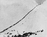
Within sight of the pass, and at the base of the "Golden Stairs" (the long difficult incline that leads to the pass), are The Scales. The Scales were a weight station where freight would be reweighed before the final trek to the pass. Often, Native packers would demand higher packing rates. The Scales also hosted a small tent city, including six restaurants, two hotels, a saloon, and many freighting offices and warehouses. The imposing Golden Stairs also prompted many would-be prospectors to turn around, often leaving behind their required ton of equipment. Because of this, and the snow's preserving properties, artifacts are prevalent at this altitude, including many remnants of wooden structures.After The Scales is the final push up to the Chilkoot Pass — the fabled Golden Stairs. The Golden Stairs acquired its name from the steps that prospectors painstakingly carved into the snow and ice of the pass and has retained the name ever since. At the pass proper, at the U.S.-Canadian border, is a warming cabin and part-time Parks Canada
Parks Canada
Parks Canada , also known as the Parks Canada Agency , is an agency of the Government of Canada mandated to protect and present nationally significant natural and cultural heritage, and foster public understanding, appreciation, and enjoyment in ways that ensure their ecological and commemorative...
warden station. Occasionally, if a party is making poor time, the warden or U.S. ranger will offer the warming cabin as an overnight shelter so to not risk the group from being caught in the barren and exposed alpine landscape between the pass and Happy Camp. There are also many artifacts scattered about the Golden Stairs and ridge lines surrounding the pass, including a cache of intact (canvas, wood, etc.) prefabricated boats on the southeastern side of the pass.
Stone Crib is situated a half mile after the pass. Stone Crib served as the terminus of the Chilkoot Railroad and Transport Company's aerial tramway, a huge rocky counterbalance for the tram. This function is still apparent today with the wooden structure well preserved by the snow.
The trail then wends its way by a series of alpine lakes: First Crater Lake, then Morrow Lake, and finally Happy Camp.
Boreal forest zone
The trail continues to pass another couple of lakes—Long Lake and Deep Lake—before crossing tree line. Adjacent to Deep Lake, and amidst tree line, is another campground.The Canadian half of the Chilkoot Trail, in the rain shadow
Rain shadow
A rain shadow is a dry area on the lee side of a mountainous area. The mountains block the passage of rain-producing weather systems, casting a "shadow" of dryness behind them. As shown by the diagram to the right, the warm moist air is "pulled" by the prevailing winds over a mountain...
of the Coast Mountains, is much dryer, and pine forest, first appearing at Deep Lake, readily contrasts to the more lush temperate rain forest
Temperate rain forest
Temperate rainforests are coniferous or broadleaf forests that occur in the temperate zone and receive high rainfall.-Definition:For temperate rain forests of North America, Alaback's definition is widely recognized:-Global distribution:...
on the U.S. half before Chilkoot Pass.
After the trail passes Deep Lake, the outlet river runs parallel to the trail for a short distance before entering a small canyon. Many boat and boat-related artifacts are visible in this area. The trail continues at a gentle decline until the turquoise-colored Lake Lindeman comes into view and the trail concludes its descent to the Lake Lindeman campground, the headquarters of Canadian trail operations.
The trail climbs a steep bluff after Lindeman and offers an expansive view of the lake and surrounding forest. After Lake Lindeman, the trail passes Bare Loon Lake and the Bare Loon Lake campground.
The trail diverges after Bare Loon Lake. One branch continues to Lake Bennett and the tracks of the White Pass and Yukon Route railroad. The other branch, the Log Cabin cut-off, connects with the Klondike Highway
Klondike Highway
The Klondike Highway links the Alaskan coastal town of Skagway to Yukon's Dawson City and its route somewhat parallels that used by prospectors in the 1898 Klondike Gold Rush....
.
Bennett consists of a campground, a White Pass and Yukon Route depot, several houses (all private property) belonging to White Pass employees or First Nations citizens, and the only gold rush-era building still standing along the trail today, the renovated St. Andrew's Presbyterian Church. Pilings from bygone piers dot the lakeshore and an assortment of cans and other metal artifacts are scattered throughout the woods.
Campgrounds
As shown on the route map there are a total of nine designated, maintained campgrounds on the Chilkoot Trail. Camping is allowed in these places only. Hikers can use their own tents or the cabins at the campground if they are available. For heating a backpacking stove must be brought along, even though wood stoves are available in some places. Open fires are prohibited. Use of campgrounds must be planned in advance.In addition to the camps, a U.S. Ranger Station is located north of Sheep Camp to present the history of the pass and inform about weather and trail conditions before crossing the summit.
Safety
Bears are the primary safety concern in the park. It is very common for hikers to encounter them. FirearmFirearm
A firearm is a weapon that launches one, or many, projectile at high velocity through confined burning of a propellant. This subsonic burning process is technically known as deflagration, as opposed to supersonic combustion known as a detonation. In older firearms, the propellant was typically...
s are not permitted. Almost all parties take bear spray
Pepper spray
Pepper spray, also known as OC spray , OC gas, and capsicum spray, is a lachrymatory agent that is used in riot control, crowd control and personal self-defense, including defense against dogs and bears...
and/or bear bangers as repellents (bear bells are now considered an attractant), but more importantly both sides of the park mandate smart bear practices. It is required to stow food in bear-safe locations.
Weather and terrain also pose a challenge to hikers. There are few risks in the forest regions of the trail, however once the trail climbs into the alpine, weather and the elements pose more of a concern; the same does vertigo. Often the American ranger from Sheep Camp sweeps late in the day up to Chilkoot Pass to monitor for straggling groups that may not make Happy Camp and would be in need of emergency shelter.
Klondike supply list
The list shows a suggestion of equipment needed for prospectors before they were allowed entry into Canada at the summit of the Chilkoot Pass, 1897-1899. Total weight: 1 ton. (See also: Klondike era)See also
- BackpackingBackpacking (wilderness)Backpacking combines the activities of hiking and camping for an overnight stay in backcountry wilderness...
- Long-distance trails in the United StatesLong-distance trails in the United StatesThe following is a list of long-distance trails in the United States:- See also :*National Millennium Trail project - 16 long-distance trails selected in 2000 as visionary trails that reflect defining aspects America's history and culture...
- List of national historic sites of Canada