

Cheddar Yeo
Encyclopedia
The Cheddar Yeo is a small river in North Somerset
, England. Beneath the limestone of the Mendip Hills
it forms the largest underground river system in Britain. After emerging into Cheddar Gorge it flows through the village of Cheddar, where it has been used in the past to power mills. From the middle ages until the 19th century the river had ports for seagoing vessels but is no longer navigable. Some of the water, which is of good quality, is diverted into Cheddar Reservoir
to provide drinking water for Bristol
.
 The Yeo rises from a spring near Charterhouse
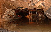
and then disappears under the Limestone of the Mendip Hills
before reappearing in Gough's Cave
before emerging into Cheddar Gorge. Within Gough's Cave the river forms the largest underground river system in Britain. From a point relatively close to the areas of the cave open to the public, the cave-divers'
descent into Sump
1a begins through a tight passage known as Dire Straits. The bottom of that passage opens into the river passage, which is several meters across. This has been explored for 335 m (1,099.1 ft) downstream, whilst upstream a dive of 150 m (492.1 ft) brings the diver out in a 20 m (65.6 ft) long chamber named Lloyd Hall (which can now also be reached by an alternative, dry, route). Another dive of 140 m (459.3 ft) through Sump 1b, finishing with an ascent through a rising passage, leads to another chamber, 60 metres (197 ft) long and 25 metres (82 ft) wide at its widest point, and full of large boulders, called Bishop's Palace. This chamber is the largest chamber currently found in the Cheddar caves. Further on, three sump pools (named the Duck Ponds) lead to Sump 2 which is about 27 metres (89 ft) deep at its lowest point and 150 metres (492 ft) long. Air is again reached at Sheppard's Crook, which is followed by Sump 3. This sump is 55 metres (180 ft) deep and at its bottommost point is about 30 metres (98 ft) below sea level. Following Sump 3, a wide ascending passage continues for 370 metres (1,214 ft) before reaching an impassable blockage, still below the water's surface.
After emerging from the cave the river flows through Cheddar
past the site of a Saxon
palace, in the grounds of The Kings of Wessex School, together with a 14th-century chapel dedicated to St. Columbanus
. Roman
remains have also been uncovered at the site.
It then flows south under a disused railway bridge which used to carry the Cheddar Valley line
and west through Rackley before joining the River Axe.
The catchment area is 54 sqkm.
s on the river. In the 17th and 18th centuries, there were several watermills which ground corn and made paper, with 13 mills on the Yeo at the peak, declining to seven by 1791 and just three by 1915.
In the Victorian era
it also became a centre for the production of clothing. The last mill in Cheddar, which was used as a shirt factory, closed in the early 1950s.
Rackley was a trading port in the Middle Ages following construction of a wharf in 1200. In 1324 Edward II
confirmed it as a borough, however by the end of the 14th century the port was in decline. In the 14th century a French ship sailed up the river and by 1388 Thomas Tanner from Wells
used Rackley to export cloth and corn
to Portugal
, and received iron
and salt
in exchange. Later slate was imported through this route and it may have still be possible to trade through Rackley until the act of 1915 authorising the drainage of the Axe and installation of the flood gate at Bleadon
.
There was also a small port at Hythe on the Wedmore Road, just south of Cheddar, which was used until the 19th century.
which is a circular artificial reservoir operated by Bristol Water
. The inlet grate for the 54 inches (1.4 m) water pipe that is used to transport the water can be seen next to the sensory garden in Cheddar Gorge. Dating from the 1930s, the reservoir has a capacity of 135 million impgals (613,722.2 m³). It has been designated as a Site of Special Scientific Interest
(SSSI) due to its wintering waterfowl populations.
In 2007 it announced that the new reservoir close to the existing site would be one of the options considered in its Draft 2009 Water Resources Plan. The new reservoir would hold 6,000 million litres, roughly the same size as the existing reservoir, and built on the alluvial flood plain the Cheddar Yeo.
have rated the Cheddar Yeo as having very good water quality chemically and good biologically. It has a high levels of nitrate
s with 20.91 mg/l in 2002-2004.
North Somerset
North Somerset is a unitary authority in England. Its area covers part of the ceremonial county of Somerset but it is administered independently of the non-metropolitan county. Its administrative headquarters is in the town hall in Weston-super-Mare....
, England. Beneath the limestone of the Mendip Hills
Mendip Hills
The Mendip Hills is a range of limestone hills to the south of Bristol and Bath in Somerset, England. Running east to west between Weston-super-Mare and Frome, the hills overlook the Somerset Levels to the south and the Avon Valley to the north...
it forms the largest underground river system in Britain. After emerging into Cheddar Gorge it flows through the village of Cheddar, where it has been used in the past to power mills. From the middle ages until the 19th century the river had ports for seagoing vessels but is no longer navigable. Some of the water, which is of good quality, is diverted into Cheddar Reservoir
Cheddar Reservoir
Cheddar Reservoir is an artificial reservoir in Somerset, England, operated by Bristol Water. Dating from the 1930s it has a capacity of 135 million gallons . The reservoir is supplied with water taken from the Cheddar Yeo river in Cheddar Gorge...
to provide drinking water for Bristol
Bristol
Bristol is a city, unitary authority area and ceremonial county in South West England, with an estimated population of 433,100 for the unitary authority in 2009, and a surrounding Larger Urban Zone with an estimated 1,070,000 residents in 2007...
.
Course
Charterhouse, Somerset
Charterhouse, also known as Charterhouse-on-Mendip, is a hamlet in the Mendip Hills Area of Outstanding Natural Beauty in the English county of Somerset...
and then disappears under the Limestone of the Mendip Hills
Mendip Hills
The Mendip Hills is a range of limestone hills to the south of Bristol and Bath in Somerset, England. Running east to west between Weston-super-Mare and Frome, the hills overlook the Somerset Levels to the south and the Avon Valley to the north...
before reappearing in Gough's Cave
Gough's Cave
Gough's Cave is located in Cheddar Gorge on the Mendip Hills, in Cheddar, Somerset, England. The cave is deep and is long,and contains a variety of large chambers and rock formations. It contains the Cheddar Yeo, the largest underground river system in Britain.- History :The initial sections of...
before emerging into Cheddar Gorge. Within Gough's Cave the river forms the largest underground river system in Britain. From a point relatively close to the areas of the cave open to the public, the cave-divers'
Cave diving
Cave diving is a type of technical diving in which specialized equipment is used to enable the exploration of caves which are at least partially filled with water. In the United Kingdom it is an extension of the more common sport of caving, and in the United States an extension of the more common...
descent into Sump
Sump (cave)
Sump is a term used in caving to describe a submerged passage in a cave. A sump may be static, with no inward or outward flow, or active, with continuous through-flow...
1a begins through a tight passage known as Dire Straits. The bottom of that passage opens into the river passage, which is several meters across. This has been explored for 335 m (1,099.1 ft) downstream, whilst upstream a dive of 150 m (492.1 ft) brings the diver out in a 20 m (65.6 ft) long chamber named Lloyd Hall (which can now also be reached by an alternative, dry, route). Another dive of 140 m (459.3 ft) through Sump 1b, finishing with an ascent through a rising passage, leads to another chamber, 60 metres (197 ft) long and 25 metres (82 ft) wide at its widest point, and full of large boulders, called Bishop's Palace. This chamber is the largest chamber currently found in the Cheddar caves. Further on, three sump pools (named the Duck Ponds) lead to Sump 2 which is about 27 metres (89 ft) deep at its lowest point and 150 metres (492 ft) long. Air is again reached at Sheppard's Crook, which is followed by Sump 3. This sump is 55 metres (180 ft) deep and at its bottommost point is about 30 metres (98 ft) below sea level. Following Sump 3, a wide ascending passage continues for 370 metres (1,214 ft) before reaching an impassable blockage, still below the water's surface.
After emerging from the cave the river flows through Cheddar
Cheddar
Cheddar is a large village and civil parish in the Sedgemoor district of the English county of Somerset. It is situated on the southern edge of the Mendip Hills, north-west of Wells. The civil parish includes the hamlets of Nyland and Bradley Cross...
past the site of a Saxon
Anglo-Saxons
Anglo-Saxon is a term used by historians to designate the Germanic tribes who invaded and settled the south and east of Great Britain beginning in the early 5th century AD, and the period from their creation of the English nation to the Norman conquest. The Anglo-Saxon Era denotes the period of...
palace, in the grounds of The Kings of Wessex School, together with a 14th-century chapel dedicated to St. Columbanus
Columbanus
Columbanus was an Irish missionary notable for founding a number of monasteries on the European continent from around 590 in the Frankish and Lombard kingdoms, most notably Luxeuil and Bobbio , and stands as an exemplar of Irish missionary activity in early medieval Europe.He spread among the...
. Roman
Ancient Rome
Ancient Rome was a thriving civilization that grew on the Italian Peninsula as early as the 8th century BC. Located along the Mediterranean Sea and centered on the city of Rome, it expanded to one of the largest empires in the ancient world....
remains have also been uncovered at the site.
It then flows south under a disused railway bridge which used to carry the Cheddar Valley line
Cheddar Valley line
The Cheddar Valley line was a railway line in Somerset, England, opened in 1869 and closed in 1963. It became known as The Strawberry Line because of the volume of locally-grown strawberries that it carried....
and west through Rackley before joining the River Axe.
The catchment area is 54 sqkm.
History
As early as 1527 there are records of watermillWatermill
A watermill is a structure that uses a water wheel or turbine to drive a mechanical process such as flour, lumber or textile production, or metal shaping .- History :...
s on the river. In the 17th and 18th centuries, there were several watermills which ground corn and made paper, with 13 mills on the Yeo at the peak, declining to seven by 1791 and just three by 1915.
In the Victorian era
Victorian era
The Victorian era of British history was the period of Queen Victoria's reign from 20 June 1837 until her death on 22 January 1901. It was a long period of peace, prosperity, refined sensibilities and national self-confidence...
it also became a centre for the production of clothing. The last mill in Cheddar, which was used as a shirt factory, closed in the early 1950s.
Rackley was a trading port in the Middle Ages following construction of a wharf in 1200. In 1324 Edward II
Edward II of England
Edward II , called Edward of Caernarfon, was King of England from 1307 until he was deposed by his wife Isabella in January 1327. He was the sixth Plantagenet king, in a line that began with the reign of Henry II...
confirmed it as a borough, however by the end of the 14th century the port was in decline. In the 14th century a French ship sailed up the river and by 1388 Thomas Tanner from Wells
Wells
Wells is a cathedral city and civil parish in the Mendip district of Somerset, England, on the southern edge of the Mendip Hills. Although the population recorded in the 2001 census is 10,406, it has had city status since 1205...
used Rackley to export cloth and corn
Cereal
Cereals are grasses cultivated for the edible components of their grain , composed of the endosperm, germ, and bran...
to Portugal
Portugal
Portugal , officially the Portuguese Republic is a country situated in southwestern Europe on the Iberian Peninsula. Portugal is the westernmost country of Europe, and is bordered by the Atlantic Ocean to the West and South and by Spain to the North and East. The Atlantic archipelagos of the...
, and received iron
Iron
Iron is a chemical element with the symbol Fe and atomic number 26. It is a metal in the first transition series. It is the most common element forming the planet Earth as a whole, forming much of Earth's outer and inner core. It is the fourth most common element in the Earth's crust...
and salt
Edible salt
Salt, also known as table salt, or rock salt, is a mineral that is composed primarily of sodium chloride , a chemical compound belonging to the larger class of ionic salts. It is essential for animal life in small quantities, but is harmful to animals and plants in excess...
in exchange. Later slate was imported through this route and it may have still be possible to trade through Rackley until the act of 1915 authorising the drainage of the Axe and installation of the flood gate at Bleadon
Bleadon
Bleadon is a village and civil parish in the historic countyof Somerset, England. It is about south of Weston-super-Mare and, according to the 2001 census, has a population of 1,068.-History:...
.
There was also a small port at Hythe on the Wedmore Road, just south of Cheddar, which was used until the 19th century.
Reservoir
Water from the river also flows into Cheddar ReservoirCheddar Reservoir
Cheddar Reservoir is an artificial reservoir in Somerset, England, operated by Bristol Water. Dating from the 1930s it has a capacity of 135 million gallons . The reservoir is supplied with water taken from the Cheddar Yeo river in Cheddar Gorge...
which is a circular artificial reservoir operated by Bristol Water
Bristol Water
Bristol Water supplies 300 million litres of drinking water to over 1 million customers in a area centred on Bristol, England. It is regulated under the Water Industry Act 1991...
. The inlet grate for the 54 inches (1.4 m) water pipe that is used to transport the water can be seen next to the sensory garden in Cheddar Gorge. Dating from the 1930s, the reservoir has a capacity of 135 million impgals (613,722.2 m³). It has been designated as a Site of Special Scientific Interest
Site of Special Scientific Interest
A Site of Special Scientific Interest is a conservation designation denoting a protected area in the United Kingdom. SSSIs are the basic building block of site-based nature conservation legislation and most other legal nature/geological conservation designations in Great Britain are based upon...
(SSSI) due to its wintering waterfowl populations.
In 2007 it announced that the new reservoir close to the existing site would be one of the options considered in its Draft 2009 Water Resources Plan. The new reservoir would hold 6,000 million litres, roughly the same size as the existing reservoir, and built on the alluvial flood plain the Cheddar Yeo.
Water quality
The Environment AgencyEnvironment Agency
The Environment Agency is a British non-departmental public body of the Department for Environment, Food and Rural Affairs and an Assembly Government Sponsored Body of the Welsh Assembly Government that serves England and Wales.-Purpose:...
have rated the Cheddar Yeo as having very good water quality chemically and good biologically. It has a high levels of nitrate
Nitrate
The nitrate ion is a polyatomic ion with the molecular formula NO and a molecular mass of 62.0049 g/mol. It is the conjugate base of nitric acid, consisting of one central nitrogen atom surrounded by three identically-bonded oxygen atoms in a trigonal planar arrangement. The nitrate ion carries a...
s with 20.91 mg/l in 2002-2004.