
Cheddar Valley line
Encyclopedia
The Cheddar Valley line was a railway line in Somerset
, England, opened in 1869 and closed in 1963. It became known as The Strawberry Line because of the volume of locally-grown strawberries
that it carried.
It ran from Yatton railway station
through to Wells (Tucker Street) railway station
. Here it joined the East Somerset Railway to make a through route via Shepton Mallet (High Street) railway station
to Witham
. Sections of the now-disused railway have been opened as the Strawberry Line Trail, which currently runs from Yatton to Cheddar.
 In the middle of the 19th century there were a large number of railway companies operating and this, in part, led to the line being built in several sections. The first section built was the East Somerset Railway
from Witham
to Shepton Mallet, opening on 9 November 1858. The line was extended to Wells, opening on 1 March 1862. This extended line was bought by the Great Western Railway
(GWR) in 1874.
Meanwhile, Yatton was under the control of the Bristol and Exeter Railway
, which opened the branch through to Cheddar on 3 August 1869, although the station had existed since 1841. This was extended to Wells on 5 April 1870, with the opening of the Tucker Street station
, but the link through to the East Somerset line from Witham was not completed until 1878, and involved passing through a third Wells station, Wells (Priory Road)
and using a section of track owned and operated by the Somerset and Dorset Joint Railway
. The S&DJR was already standard gauge by this time, and the other two railways had moved from broad gauge to standard gauge in 1875. The Bristol and Exeter was acquired by the GWR in 1876, and the integrated service ran from Yatton through to Witham, which became the standard service for this line from 1878. The line was single-track for most of the journey between Yatton and Wells, apart from the junction at Congresbury
. At Wells, trains ran through the Priory Road S&DJR station without stopping until 1934, and that station remained open as the terminus of the short branch line from Glastonbury and Street
until the branch closure in 1951 left Tucker Street as the last remaining Wells station.
The prime motivation for the line to Cheddar and Draycott
was to provide transport for strawberries
, and Cheddar cheese
. This led to its nickname the Strawberry Line. The pub opposite the station in Draycott is now called The Strawberry Special.
On 4 December 1901, the Wrington Vale Light Railway
opened a branch from Congresbury to Blagdon
. This survived until 14 September 1931 for passenger traffic, and 1 November 1950 for goods traffic.
The Cheddar Valley line survived until the "Beeching Axe
". Towards the end of its life, there were so few passengers that diesel railcar
s were sometimes used. The Cheddar branch closed to passengers on 9 September 1963 and to goods in 1964. The line closed in the 1960s, when it became part of the Cheddar Valley Railway Nature Reserve.
 The disused line between and today forms The Strawberry Line, a railway walk and part of the National Cycle Network
route 26.
The trail starts at Yatton railway station
and is in good condition most of the way to the site of Congresbury railway station
, although it is necessary to follow a farm track near Congresbury as the railway bridge over the Congresbury Yeo
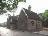
river has been demolished. The platforms
of the former station here remain, as do houses built for railway workers. Although the platforms are currently covered in vegetation and in need of repair due to root damage, the track bed between platforms is clear of undergrowth and as of July 2008 has been levelled with a fine gravel surface applied.
The route to Sandford
continues with wide quality surfacing, although currently lacking in seats with none for over 3 miles (5 km). Upon reaching the rail bridge on the outskirts of Sandford the trail joins Nye Road (a country lane) for approximately 0.44 mile (0.7081096 km), before turning right into the new (June 2009) off-road link. To avoid travelling along the A368
, the link passes next to orchards and crosses a large field before rejoining the track bed for a short stretch to the A368. After crossing the road the site of Sandford & Banwell
station becomes visible. The grade II listed buildings, and platform were preserved by the original owners Sandford Stone, the site has since been redeveloped as "Sandford Station Retirement Village" a sheltered housing
complex. The route goes around the perimeter with a view of the station, goods shed
and platform including a short section of track complete with period carriage and open wagons. The station is now restored and open to the public on summer weekends with access from the trail.
The scenery through to Winscombe
changes from open moorland to railway cuttings, with the path in condition to match the previous sections. Upon reaching the site of the former station now being the villages Millennium Green
the platform is preserved, and a time line of local and world events inserted along its length. The small red bricked facade of the demolished station building has been laid flat into is former foundation, and the layout of rooms can still be seen. Seats and lighting have been provided with public toilets also available to the rear of the platform at street level.
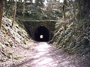
After Winscombe the line continues to Shute Shelve Tunnel, the surface through has been tarmac
ed but unlit except for a central guide line of small solar powered "cat's eyes
" automatically switched on by pedestrians or cyclists entering the tunnel. It passes under the Mendip Way
and a narrow point in the Mendip Hills
. From this point eastwards the line follows the southern edge of the Mendips crossing the Cheddar Yeo
. The track bed around Axbridge
is now the A371
bypass, but the station building, goods shed and station master's house are all in use for various purposes. The Strawberry Line Trail goes through the town itself missing out the station site higher on the hillside behind the church.
The railway track is regained opposite St Michael's Cheshire Home and is in good condition through to Cheddar, with a picnic spot overlooking the reservoir. The route comes to an end at the side of the former station now in use as a stonemason's surrounded by a small industrial estate, just 1 miles (2 km) from Cheddar Gorge.
A roadsign in Draycott still bears the legend "Draycott Station 1/4 mile" (although the embossed letters are now painted over), and there are tunnels currently used as a bridges in Draycott and neighbouring Rodney Stoke
The nature reserve which is based around the old railway line has been reclaimed by nature. Habitats include dense scrub, which encourages birds and bats. Areas of rough grass are occupied by amphibians and reptiles, and grass snakes or slow worms can be seen basking in the sun. It also includes parts of the Biddle Street
Site of Special Scientific Interest
.
were published on the 28th May 2009, in places the old railway has been built on but the plan is to follow the line as closely as possible. The "Safe Paths for All" campaign also aims to extend the route from Wells to Shepton Mallet
and Cranmore
by 2012.
At the other end of the route a feasibility study has been undertaken by North Somerset Council, which would see an extension from Yatton to Clevedon
along the former Clevedon branch line
. Again parts of the line have been built on and station buildings at Clevedon no longer exist.
A footbridge over the Congresbury Yeo in place of the long demolished rail bridge is also planned.
Somerset
The ceremonial and non-metropolitan county of Somerset in South West England borders Bristol and Gloucestershire to the north, Wiltshire to the east, Dorset to the south-east, and Devon to the south-west. It is partly bounded to the north and west by the Bristol Channel and the estuary of the...
, England, opened in 1869 and closed in 1963. It became known as The Strawberry Line because of the volume of locally-grown strawberries
Strawberry
Fragaria is a genus of flowering plants in the rose family, Rosaceae, commonly known as strawberries for their edible fruits. Although it is commonly thought that strawberries get their name from straw being used as a mulch in cultivating the plants, the etymology of the word is uncertain. There...
that it carried.
It ran from Yatton railway station
Yatton railway station
Yatton railway station serves the village of Yatton in North Somerset, England. It is west of Bristol Temple Meads railway station on the Bristol to Taunton Line.-History:...
through to Wells (Tucker Street) railway station
Wells (Tucker Street) railway station
Wells railway station was the second terminus station on the Bristol and Exeter Railway's Cheddar Valley line in Somerset after the extension from the first terminus at Cheddar was opened...
. Here it joined the East Somerset Railway to make a through route via Shepton Mallet (High Street) railway station
Shepton Mallet (High Street) railway station
Shepton Mallet was a railway station on the East Somerset Railway, serving the town of Shepton Mallet in the English county of Somerset....
to Witham
Witham (Somerset) railway station
Witham railway station was a station serving the Somerset village of Witham Friary and was located on the Frome to Yeovil section of the Wilts, Somerset and Weymouth Railway that opened in 1856...
. Sections of the now-disused railway have been opened as the Strawberry Line Trail, which currently runs from Yatton to Cheddar.
History
East Somerset Railway
The East Somerset Railway is a heritage railway in Somerset, running between Cranmore and Mendip Vale. Prior to the Beeching Axe, the railway ran from Witham to Wells, meeting both the Cheddar Valley line and Somerset and Dorset Joint Railway at the latter station.- History :The line was...
from Witham
Witham (Somerset) railway station
Witham railway station was a station serving the Somerset village of Witham Friary and was located on the Frome to Yeovil section of the Wilts, Somerset and Weymouth Railway that opened in 1856...
to Shepton Mallet, opening on 9 November 1858. The line was extended to Wells, opening on 1 March 1862. This extended line was bought by the Great Western Railway
Great Western Railway
The Great Western Railway was a British railway company that linked London with the south-west and west of England and most of Wales. It was founded in 1833, received its enabling Act of Parliament in 1835 and ran its first trains in 1838...
(GWR) in 1874.
Meanwhile, Yatton was under the control of the Bristol and Exeter Railway
Bristol and Exeter Railway
The Bristol & Exeter Railway was a railway company formed to connect Bristol and Exeter.The company's head office was situated outside their Bristol station...
, which opened the branch through to Cheddar on 3 August 1869, although the station had existed since 1841. This was extended to Wells on 5 April 1870, with the opening of the Tucker Street station
Wells (Tucker Street) railway station
Wells railway station was the second terminus station on the Bristol and Exeter Railway's Cheddar Valley line in Somerset after the extension from the first terminus at Cheddar was opened...
, but the link through to the East Somerset line from Witham was not completed until 1878, and involved passing through a third Wells station, Wells (Priory Road)
Wells (Priory Road) railway station
Wells was a railway station on the Somerset and Dorset Joint Railway at Wells in the county of Somerset in England. Opening on 15 March 1859 as Wells, on the Somerset Central Railway, at that time a broad-gauge line operated by the Bristol and Exeter Railway, it was the terminus of the branch from...
and using a section of track owned and operated by the Somerset and Dorset Joint Railway
Somerset and Dorset Joint Railway
The Somerset & Dorset Joint Railway – almost always referred to as "the S&D" – was an English railway line connecting Bath in north east Somerset and Bournemouth now in south east Dorset but then in Hampshire...
. The S&DJR was already standard gauge by this time, and the other two railways had moved from broad gauge to standard gauge in 1875. The Bristol and Exeter was acquired by the GWR in 1876, and the integrated service ran from Yatton through to Witham, which became the standard service for this line from 1878. The line was single-track for most of the journey between Yatton and Wells, apart from the junction at Congresbury
Congresbury
Congresbury is a village and civil parish in Somerset, England. It is situated in the Unitary authority of North Somerset, and in 2001 had a population of 3,400. It lies on the A370, roughly equidistant between Junction 21 of the M5 and Bristol Airport, approximately south of Bristol city centre,...
. At Wells, trains ran through the Priory Road S&DJR station without stopping until 1934, and that station remained open as the terminus of the short branch line from Glastonbury and Street
Glastonbury and Street railway station
Glastonbury and Street railway station was the biggest station on the original Somerset and Dorset Joint Railway main line from Highbridge to Evercreech Junction until closed in 1966 under the Beeching axe...
until the branch closure in 1951 left Tucker Street as the last remaining Wells station.
The prime motivation for the line to Cheddar and Draycott
Draycott, Somerset
Draycott is a small village in Somerset, England, neighbouring the village of Cheddar on the southern edge of the Mendip Hills Area of Outstanding Natural Beauty...
was to provide transport for strawberries
Strawberry
Fragaria is a genus of flowering plants in the rose family, Rosaceae, commonly known as strawberries for their edible fruits. Although it is commonly thought that strawberries get their name from straw being used as a mulch in cultivating the plants, the etymology of the word is uncertain. There...
, and Cheddar cheese
Cheddar cheese
Cheddar cheese is a relatively hard, yellow to off-white, and sometimes sharp-tasting cheese, produced in several countries around the world. It has its origins in the English village of Cheddar in Somerset....
. This led to its nickname the Strawberry Line. The pub opposite the station in Draycott is now called The Strawberry Special.
On 4 December 1901, the Wrington Vale Light Railway
Wrington Vale Light Railway
The Wrington Vale Light Railway was a railway from Congresbury on the Cheddar Valley line to Blagdon, and serving villages in the Yeo Valley, North Somerset...
opened a branch from Congresbury to Blagdon
Blagdon
Blagdon is a village and civil parish in the ceremonial county of Somerset, within the unitary authority of North Somerset, in England. It is located in the Mendip Hills, a recognised Area of Outstanding Natural Beauty. According to the 2001 census it has a population of 1,172...
. This survived until 14 September 1931 for passenger traffic, and 1 November 1950 for goods traffic.
The Cheddar Valley line survived until the "Beeching Axe
Beeching Axe
The Beeching Axe or the Beeching Cuts are informal names for the British Government's attempt in the 1960s to reduce the cost of running British Railways, the nationalised railway system in the United Kingdom. The name is that of the main author of The Reshaping of British Railways, Dr Richard...
". Towards the end of its life, there were so few passengers that diesel railcar
Railcar
A railcar, in British English and Australian English, is a self-propelled railway vehicle designed to transport passengers. The term "railcar" is usually used in reference to a train consisting of a single coach , with a driver's cab at one or both ends. Some railways, e.g., the Great Western...
s were sometimes used. The Cheddar branch closed to passengers on 9 September 1963 and to goods in 1964. The line closed in the 1960s, when it became part of the Cheddar Valley Railway Nature Reserve.
Strawberry Line trail
National Cycle Network
The National Cycle Network is a network of cycle routes in the United Kingdom.The National Cycle Network was created by the charity Sustrans , and aided by a £42.5 million National Lottery grant. In 2005 it was used for over 230 million trips.Many routes hope to minimise contact with motor...
route 26.
The trail starts at Yatton railway station
Yatton railway station
Yatton railway station serves the village of Yatton in North Somerset, England. It is west of Bristol Temple Meads railway station on the Bristol to Taunton Line.-History:...
and is in good condition most of the way to the site of Congresbury railway station
Congresbury railway station
Congresbury railway station was a station at Congresbury on the Bristol and Exeter Railway's Cheddar Valley line in Somerset and the junction for the Wrington Vale Light Railway to Blagdon....
, although it is necessary to follow a farm track near Congresbury as the railway bridge over the Congresbury Yeo
Congresbury Yeo
The River Yeo is a river which flows through North Somerset, England.- River course :...
river has been demolished. The platforms
Railway platform
A railway platform is a section of pathway, alongside rail tracks at a train station, metro station or tram stop, at which passengers may board or alight from trains or trams. Almost all stations for rail transport have some form of platforms, with larger stations having multiple platforms...
of the former station here remain, as do houses built for railway workers. Although the platforms are currently covered in vegetation and in need of repair due to root damage, the track bed between platforms is clear of undergrowth and as of July 2008 has been levelled with a fine gravel surface applied.
The route to Sandford
Sandford, Somerset
Sandford is a village between Churchill and Banwell on the A368 in North Somerset, England.The Parish of Winscombe and Sandford, centred around the Parish Church of Saint James, includes the villages of Barton, Oakridge, Sandford, Sidcot and Woodborough....
continues with wide quality surfacing, although currently lacking in seats with none for over 3 miles (5 km). Upon reaching the rail bridge on the outskirts of Sandford the trail joins Nye Road (a country lane) for approximately 0.44 mile (0.7081096 km), before turning right into the new (June 2009) off-road link. To avoid travelling along the A368
A368 road
The A368 is a part primary status A road in North Somerset, England. It runs from Marksbury to Banwell along the northern edge of the Mendip Hills and past the reservoir at Chew Valley Lake....
, the link passes next to orchards and crosses a large field before rejoining the track bed for a short stretch to the A368. After crossing the road the site of Sandford & Banwell
Banwell
Banwell is a village and civil parish on the River Banwell in the North Somerset district of Somerset, England. Its population was 2,923 according to the 2001 census.-History:...
station becomes visible. The grade II listed buildings, and platform were preserved by the original owners Sandford Stone, the site has since been redeveloped as "Sandford Station Retirement Village" a sheltered housing
Sheltered housing
Sheltered housing is a British English term covering a wide range of rented housing for older and/or disabled or other vulnerable people. Most commonly it refers to grouped housing such as a block or "scheme" of flats or bungalows with a scheme manager or "officer"; traditionally the manager has...
complex. The route goes around the perimeter with a view of the station, goods shed
Goods shed
A goods shed is a railway building designed for storing goods before or after carriage in a train.A typical goods shed will have a track running through it to allow goods wagons to be unloaded under cover, although sometimes they were built alongside a track with possibly just a canopy over the door...
and platform including a short section of track complete with period carriage and open wagons. The station is now restored and open to the public on summer weekends with access from the trail.
The scenery through to Winscombe
Winscombe
Winscombe is a village in North Somerset, England, close to the settlements of Axbridge and Cheddar, on the western edge of the Mendip Hills, south-east of Weston-super-Mare and south-west of Bristol...
changes from open moorland to railway cuttings, with the path in condition to match the previous sections. Upon reaching the site of the former station now being the villages Millennium Green
Millennium Green
245 Millennium Greens were created in cities, towns and villages across England to celebrate the turn of the Millennium. Funded in part by the National Lottery via the Countryside Agency, they are permanent areas of green space for the benefit of local communities...
the platform is preserved, and a time line of local and world events inserted along its length. The small red bricked facade of the demolished station building has been laid flat into is former foundation, and the layout of rooms can still be seen. Seats and lighting have been provided with public toilets also available to the rear of the platform at street level.
After Winscombe the line continues to Shute Shelve Tunnel, the surface through has been tarmac
Tarmac
Tarmac is a type of road surface. Tarmac refers to a material patented by Edgar Purnell Hooley in 1901...
ed but unlit except for a central guide line of small solar powered "cat's eyes
Cat's eye (road)
The cat's eye is a retroreflective safety device used in road marking and was the first of a range of raised pavement markers. It originated in the UK in 1933 and is today used all over the world....
" automatically switched on by pedestrians or cyclists entering the tunnel. It passes under the Mendip Way
Mendip Way
The Mendip Way is an long-distance footpath across the Mendip Hills from Weston-super-Mare to Frome. It is divided into two sections.The West Mendip Way was opened in 1979 and starts at the Bristol Channel at Uphill Cliff. It climbs the Mendip escarpment affording views over the Somerset Levels....
and a narrow point in the Mendip Hills
Mendip Hills
The Mendip Hills is a range of limestone hills to the south of Bristol and Bath in Somerset, England. Running east to west between Weston-super-Mare and Frome, the hills overlook the Somerset Levels to the south and the Avon Valley to the north...
. From this point eastwards the line follows the southern edge of the Mendips crossing the Cheddar Yeo
Cheddar Yeo
The Cheddar Yeo is a small river in North Somerset, England. Beneath the limestone of the Mendip Hills it forms the largest underground river system in Britain. After emerging into Cheddar Gorge it flows through the village of Cheddar, where it has been used in the past to power mills...
. The track bed around Axbridge
Axbridge
Axbridge is a town in Somerset, England, situated in the Sedgemoor district on the River Axe, near the southern edge of the Mendip Hills. The town population according to the 2001 census was 2,024.-History:...
is now the A371
A371 road
The A371 is a primary road in England running from Wincanton in Somerset, to Weston-super-Mare in North Somerset.The A371 starts at the A303, then passes Castle Cary, Ansford, Cannard's Grave , Shepton Mallet, Croscombe, Wells, Easton, Somerset, Westbury-sub-Mendip, Rodney Stoke, Draycott, Cheddar,...
bypass, but the station building, goods shed and station master's house are all in use for various purposes. The Strawberry Line Trail goes through the town itself missing out the station site higher on the hillside behind the church.
The railway track is regained opposite St Michael's Cheshire Home and is in good condition through to Cheddar, with a picnic spot overlooking the reservoir. The route comes to an end at the side of the former station now in use as a stonemason's surrounded by a small industrial estate, just 1 miles (2 km) from Cheddar Gorge.
A roadsign in Draycott still bears the legend "Draycott Station 1/4 mile" (although the embossed letters are now painted over), and there are tunnels currently used as a bridges in Draycott and neighbouring Rodney Stoke
Rodney Stoke
Rodney Stoke is a small village and civil parish, located at , 5 miles north-west of Wells, in the English county of Somerset. The village is on the A371 between Draycott and Westbury-sub-Mendip....
The nature reserve which is based around the old railway line has been reclaimed by nature. Habitats include dense scrub, which encourages birds and bats. Areas of rough grass are occupied by amphibians and reptiles, and grass snakes or slow worms can be seen basking in the sun. It also includes parts of the Biddle Street
Biddle Street, Yatton
Biddle Street, Yatton is a 44.8 hectare biological Site of Special Scientific Interest near the village of Yatton in North Somerset, notified in 1994....
Site of Special Scientific Interest
Site of Special Scientific Interest
A Site of Special Scientific Interest is a conservation designation denoting a protected area in the United Kingdom. SSSIs are the basic building block of site-based nature conservation legislation and most other legal nature/geological conservation designations in Great Britain are based upon...
.
Future plans
Plans to extend the route along the line from Cheddar all the way to WellsWells
Wells is a cathedral city and civil parish in the Mendip district of Somerset, England, on the southern edge of the Mendip Hills. Although the population recorded in the 2001 census is 10,406, it has had city status since 1205...
were published on the 28th May 2009, in places the old railway has been built on but the plan is to follow the line as closely as possible. The "Safe Paths for All" campaign also aims to extend the route from Wells to Shepton Mallet
Shepton Mallet
Shepton Mallet is a small rural town and civil parish in the Mendip district of Somerset in South West England. Situated approximately south of Bristol and east of Wells, the town is estimated to have a population of 9,700. It contains the administrative headquarters of Mendip District Council...
and Cranmore
Cranmore, Somerset
Cranmore is a village and civil parish east of Shepton Mallet, in the Mendip district of Somerset, England. The parish includes the hamlets of Waterlip, East Cranmore and Dean where Dean farmhouse dates from the 17th century, as does The Old Smithy, just off the A361 which was originally two...
by 2012.
At the other end of the route a feasibility study has been undertaken by North Somerset Council, which would see an extension from Yatton to Clevedon
Clevedon
Clevedon is a town and civil parish in the unitary authority of North Somerset, which covers part of the ceremonial county of Somerset, England...
along the former Clevedon branch line
Clevedon branch line
The Clevedon branch line was a branch railway line that ran from Yatton railway station on the Bristol to Taunton Line to Clevedon in North Somerset, England, with no intermediate stops....
. Again parts of the line have been built on and station buildings at Clevedon no longer exist.
A footbridge over the Congresbury Yeo in place of the long demolished rail bridge is also planned.
Features
External links
- The Strawberry Line official website
- Cheddar Valley Railway Walk Society
- Cheddar Valley Railway from North Somerset Council