
Charles Mill Lake
Encyclopedia
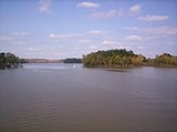
Charles Mill is a reservoir
located in central Ohio
near the junction of State Routes 430 and 603. Charles Mill Lake is a quiet and enjoyable place for boating, camping, fishing, hunting, or hiking. The lake is located in both Richland County
(near Mansfield
) and Ashland County
(near Mifflin
), with the dam
located in Ashland County. This lake is located on the Black Fork of the Mohican River
. Many local residents refer to Chales Mill Lake as Mifflin Lake due to its proximity to Mifflin, Ohio.
The lake primarily sees local use by nearby residents who fish or boat. The marina is accessible from St. Rt. 430, and there is a 10-HP (7.5 kW
) limit for boats. The marina rents and sells various watercraft and provides licensing services.
" and "English-Allied Indian Attacks." An attack took place within a mile of the dam site following the removal of the Piqua Indians from their tribal home area. The Indians first attack the home of the Frederick Zimmer family, and their neighbor Martin Rufferner, killing four. Several days later four more persons {one pioneer and three militamen} were killed while defending the home of the James Copus family, including Rev. James Copus. As you drive South on Ohio State Route 603
watch for the sign directing you to a historical monument erected to the memory of those settlers and soldiers who were killed. In 2006 a new fence was erected around the momuent, a photo is included in the photo section on this site. Members of the Copus family have held an annual reunion in this picninc area for years.
In 2004 the Johnny Appleseed Heritage Center opened nearby;
the original production is no longer presented, check with the tourism number for their offerings.
. At I-71, take US Route 30 East almost 1 miles (1.6 km) to Ohio State Route 603
. Then take Ohio State Route 603
South about 2 miles (3.2 km) to dam.
Charles Mill Dam is located on the Black Fork of the Mohican River, 10 miles (16.1 km) East of Mansfield, Ohio
and 10 miles (16.1 km) South-West of Ashland, Ohio
. The lake is located in Ashland County, Ohio
and Richland County, Ohio
with the dam being located in Ashland County, Ohio
. Charles Mill Dam was constructed in 1935 and 1936 and is primarily for flood control
but also for recreation and fish and wildlife management.
Charles Mill Dam is a rolled earth fill dam with an impervious, water resistant, clay core. The dam, is 48 feet (14.6 m) high, 1390 feet (423.7 m) long and 20 feet (6.1 m) wide. This flood reduction system also includes two dikes and one levee. These structures, the dam, dikes and levee, hold the water that may build up behind them from the 215 square miles (556.8 km²) drainage area the dam serves. The dam also has two spillway
s to handle water above the maximum the dam is designed to hold; one is built into the gate house, the other is beyond the gate house against the right abutment. There are five gates which allow the water to pass through the dam and provide control of it. During the summer months the lake is kept at about 31 feet (9.4 m) at the dam which provides 1350 acres (5.5 km²) of water surface. At that level the water is backed up the Black Fork about 5.2 miles (8.4 km). When the dam is holding the maximum flood water it is designed to hold there would be 6050 acres (24.5 km²) surface acres of water behind the dam and water would be backed up the Black Fork 19.8 miles (31.9 km).
Reservoir
A reservoir , artificial lake or dam is used to store water.Reservoirs may be created in river valleys by the construction of a dam or may be built by excavation in the ground or by conventional construction techniques such as brickwork or cast concrete.The term reservoir may also be used to...
located in central Ohio
Ohio
Ohio is a Midwestern state in the United States. The 34th largest state by area in the U.S.,it is the 7th‑most populous with over 11.5 million residents, containing several major American cities and seven metropolitan areas with populations of 500,000 or more.The state's capital is Columbus...
near the junction of State Routes 430 and 603. Charles Mill Lake is a quiet and enjoyable place for boating, camping, fishing, hunting, or hiking. The lake is located in both Richland County
Richland County, Ohio
Richland County is a county located in the state of Ohio, United States. As of the 2010 census, the population was 124,475. It is included in the Mansfield, Ohio, Metropolitan Statistical Area as well as the Mansfield–Bucyrus Combined Statistical Area....
(near Mansfield
Mansfield, Ohio
Mansfield is a city in the U.S. state of Ohio and the county seat of Richland County. The municipality is located in north-central Ohio in the western foothills of the Allegheny Plateau, approximately southwest of Cleveland and northeast of Columbus....
) and Ashland County
Ashland County, Ohio
Ashland County is a county located in the state of Ohio, United States, and was formed in 1846 from parts of Huron, Lorain, Richland and Wayne Counties. As of the 2010 census, the population was 53,139. Its county seat is Ashland...
(near Mifflin
Mifflin, Ohio
Mifflin is a village in Ashland County, Ohio, United States. The population was 144 at the 2000 census.-Geography:Mifflin is located at .According to the United States Census Bureau, the village has a total area of , all of it land....
), with the dam
Dam
A dam is a barrier that impounds water or underground streams. Dams generally serve the primary purpose of retaining water, while other structures such as floodgates or levees are used to manage or prevent water flow into specific land regions. Hydropower and pumped-storage hydroelectricity are...
located in Ashland County. This lake is located on the Black Fork of the Mohican River
Black Fork Mohican River
The Black Fork is a principal tributary of the Mohican River, 58.4 miles long, in north-central Ohio in the United States. Via the Mohican, Walhonding, Muskingum and Ohio Rivers, it is part of the watershed of the Mississippi River, draining an area of 351 square miles...
. Many local residents refer to Chales Mill Lake as Mifflin Lake due to its proximity to Mifflin, Ohio.
The lake primarily sees local use by nearby residents who fish or boat. The marina is accessible from St. Rt. 430, and there is a 10-HP (7.5 kW
Watt
The watt is a derived unit of power in the International System of Units , named after the Scottish engineer James Watt . The unit, defined as one joule per second, measures the rate of energy conversion.-Definition:...
) limit for boats. The marina rents and sells various watercraft and provides licensing services.
History
There is a Historical Marker in the Day Use Area that recounts the stories of "Frontier Violence During the War of 1812War of 1812
The War of 1812 was a military conflict fought between the forces of the United States of America and those of the British Empire. The Americans declared war in 1812 for several reasons, including trade restrictions because of Britain's ongoing war with France, impressment of American merchant...
" and "English-Allied Indian Attacks." An attack took place within a mile of the dam site following the removal of the Piqua Indians from their tribal home area. The Indians first attack the home of the Frederick Zimmer family, and their neighbor Martin Rufferner, killing four. Several days later four more persons {one pioneer and three militamen} were killed while defending the home of the James Copus family, including Rev. James Copus. As you drive South on Ohio State Route 603
Ohio State Route 603
State Route 603 is a north–south state highway in the northern portion of the U.S. state of Ohio. Its southern terminus is at State Route 95 near Perrysville, and its northern terminus is at State Routes 61 and 98 in Plymouth along the Baseline Road that separates Huron County and Richland...
watch for the sign directing you to a historical monument erected to the memory of those settlers and soldiers who were killed. In 2006 a new fence was erected around the momuent, a photo is included in the photo section on this site. Members of the Copus family have held an annual reunion in this picninc area for years.
Johnny Appleseed
Tradition holds that Johnny Appleseed raced throughout the area warning others following the attacks.In 2004 the Johnny Appleseed Heritage Center opened nearby;
the original production is no longer presented, check with the tourism number for their offerings.
Charles Mill Dam
Charles Mill Dam, near 40°44′25"N 082°21′45"W Elevation: 1017 feet (310 m), approximately 3 miles (4.8 km) East of I-71Interstate 71
Interstate 71 is an Interstate Highway in the Great Lakes/Midwestern and Southeastern region of the United States. Its southern terminus is at an interchange with Interstate 64 and Interstate 65 in Louisville, Kentucky. Its northern terminus is at an interchange with Interstate 90 in Cleveland,...
. At I-71, take US Route 30 East almost 1 miles (1.6 km) to Ohio State Route 603
Ohio State Route 603
State Route 603 is a north–south state highway in the northern portion of the U.S. state of Ohio. Its southern terminus is at State Route 95 near Perrysville, and its northern terminus is at State Routes 61 and 98 in Plymouth along the Baseline Road that separates Huron County and Richland...
. Then take Ohio State Route 603
Ohio State Route 603
State Route 603 is a north–south state highway in the northern portion of the U.S. state of Ohio. Its southern terminus is at State Route 95 near Perrysville, and its northern terminus is at State Routes 61 and 98 in Plymouth along the Baseline Road that separates Huron County and Richland...
South about 2 miles (3.2 km) to dam.
Charles Mill Dam is located on the Black Fork of the Mohican River, 10 miles (16.1 km) East of Mansfield, Ohio
Mansfield, Ohio
Mansfield is a city in the U.S. state of Ohio and the county seat of Richland County. The municipality is located in north-central Ohio in the western foothills of the Allegheny Plateau, approximately southwest of Cleveland and northeast of Columbus....
and 10 miles (16.1 km) South-West of Ashland, Ohio
Ashland, Ohio
Ashland is a city in the U.S. state of Ohio and the county seat of Ashland County. The population was 21,249 at the 2000 census. It is the center of the Ashland Micropolitan Statistical Area...
. The lake is located in Ashland County, Ohio
Ashland County, Ohio
Ashland County is a county located in the state of Ohio, United States, and was formed in 1846 from parts of Huron, Lorain, Richland and Wayne Counties. As of the 2010 census, the population was 53,139. Its county seat is Ashland...
and Richland County, Ohio
Richland County, Ohio
Richland County is a county located in the state of Ohio, United States. As of the 2010 census, the population was 124,475. It is included in the Mansfield, Ohio, Metropolitan Statistical Area as well as the Mansfield–Bucyrus Combined Statistical Area....
with the dam being located in Ashland County, Ohio
Ashland County, Ohio
Ashland County is a county located in the state of Ohio, United States, and was formed in 1846 from parts of Huron, Lorain, Richland and Wayne Counties. As of the 2010 census, the population was 53,139. Its county seat is Ashland...
. Charles Mill Dam was constructed in 1935 and 1936 and is primarily for flood control
Flood control
In communications, flood control is a feature of many communication protocols designed to prevent overwhelming of a destination receiver. Such controls can be implemented either in software or in hardware, and will often request that the message be resent after the receiver has finished...
but also for recreation and fish and wildlife management.
Charles Mill Dam is a rolled earth fill dam with an impervious, water resistant, clay core. The dam, is 48 feet (14.6 m) high, 1390 feet (423.7 m) long and 20 feet (6.1 m) wide. This flood reduction system also includes two dikes and one levee. These structures, the dam, dikes and levee, hold the water that may build up behind them from the 215 square miles (556.8 km²) drainage area the dam serves. The dam also has two spillway
Spillway
A spillway is a structure used to provide the controlled release of flows from a dam or levee into a downstream area, typically being the river that was dammed. In the UK they may be known as overflow channels. Spillways release floods so that the water does not overtop and damage or even destroy...
s to handle water above the maximum the dam is designed to hold; one is built into the gate house, the other is beyond the gate house against the right abutment. There are five gates which allow the water to pass through the dam and provide control of it. During the summer months the lake is kept at about 31 feet (9.4 m) at the dam which provides 1350 acres (5.5 km²) of water surface. At that level the water is backed up the Black Fork about 5.2 miles (8.4 km). When the dam is holding the maximum flood water it is designed to hold there would be 6050 acres (24.5 km²) surface acres of water behind the dam and water would be backed up the Black Fork 19.8 miles (31.9 km).