

Chain Home
Encyclopedia
Early warning radar
An early warning radar is any radar system used primarily for the long-range detection of its targets, i.e., allowing defences to be alerted as early as possible before the intruder reaches its target, giving the defences the maximum time in which to operate...
radar
Radar
Radar is an object-detection system which uses radio waves to determine the range, altitude, direction, or speed of objects. It can be used to detect aircraft, ships, spacecraft, guided missiles, motor vehicles, weather formations, and terrain. The radar dish or antenna transmits pulses of radio...
stations built by the British before and during the Second World War
World War II
World War II, or the Second World War , was a global conflict lasting from 1939 to 1945, involving most of the world's nations—including all of the great powers—eventually forming two opposing military alliances: the Allies and the Axis...
. The system otherwise known as AMES Type 1 (Air Ministry Experimental Station
Air Ministry Experimental Station
AMES or Air Ministry Experimental Station was the way of identifying RAF radar types during and after World War II*AMES Type 1, Chain Home - Early Warning*AMES Type 2, Chain Home Low - Early Warning, LOW altitude...
) consisted of radar fixed on top of a radio tower mast, called a 'station' to provide long-range
Early warning radar
An early warning radar is any radar system used primarily for the long-range detection of its targets, i.e., allowing defences to be alerted as early as possible before the intruder reaches its target, giving the defences the maximum time in which to operate...
detection of aircraft. This system had shortcomings in not being able to detect aircraft at lower altitudes and thus was used in conjunction with the Chain Home Low
Chain Home Low
Chain Home Low was the name of a British radar early warning system, detecting enemy aircraft movement at lower altitudes than and summarily used with the fixed Chain Home system which was operated by the RAF during World War II...
system, or AMES Type 2 which could detect aircraft flying at minimum altitude level of 500 ft.
Development
The Chain Home system was fairly primitive, since — in order to be battle-ready — it had been rushed into production by Sir Robert Watson-WattRobert Watson-Watt
Sir Robert Alexander Watson-Watt, KCB, FRS, FRAeS is considered by many to be the "inventor of radar". Development of radar, initially nameless, was first started elsewhere but greatly expanded on 1 September 1936 when Watson-Watt became...
's Air Ministry
Air Ministry
The Air Ministry was a department of the British Government with the responsibility of managing the affairs of the Royal Air Force, that existed from 1918 to 1964...
research station near Bawdsey
Bawdsey
Bawdsey is a village and civil parish in Suffolk, eastern England. Located near Felixstowe, it had an estimated population of 340 in 2007.Bawdsey Manor is notable as the place where radar research took place early in World War II, before moving to Worth Matravers, which is four miles to the west of...
. Watson-Watt, a pragmatic engineer, believed that "third-best" would do if "second-best" would not be available in time and "best" never available at all. Chain Home certainly suffered from glitches and errors in reporting.
It was in many ways technically inferior to German radar developments, but the better German technology came at a cost. The simpler Chain Home stations provided comprehensive coverage by the start of the Battle of Britain
Battle of Britain
The Battle of Britain is the name given to the World War II air campaign waged by the German Air Force against the United Kingdom during the summer and autumn of 1940...
, whereas the Germans had only commissioned around 8 of their Freya
Freya radar
Freya was an early warning radar deployed by Germany during World War II, named after the Norse Goddess Freyja. During the war over a thousand stations were built. A naval version operating on a slightly different wavelength was also developed as Seetakt...
stations by this time. Although simple, Chain Home could determine distance and direction of incoming aircraft formations. The method was called Radio Direction Finding (RDF), later called "radar" (RAdio Direction And Ranging) in the U.S. Most stations were also able to measure the angle of elevation of the formation which, together with the range, gave the height; local geography prevented some stations from measuring elevation. Although not originally a design goal, the operators became very adept at estimating the size of detected formations from the shape of the displayed returns.
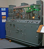
Chain Home looked nothing like later radar equipment. The antenna did not rotate: the transmitting array was formed of fixed wires strung between 110 m (360.9 ft)-high metal towers which sent out a "floodlight" beam of radio energy about 100° wide. The receiving array was on wooden towers about 73 m (239.5 ft) high, and consisted of two antennas at right angles to each other. The receiving antennas were directional, so the signal strength received by each depended on the angle between it and the target. An operator would manually adjust a comparator device to find what angle to the target best matched the relative strengths of the two received signals. The angle of elevation to the target was estimated by similar comparison of the signal strengths from a second pair of receiving antennas closer to the ground, which produced a different sensitivity in elevation. The time delay of the echo determined the range to the target.
High frequency
High frequency radio frequencies are between 3 and 30 MHz. Also known as the decameter band or decameter wave as the wavelengths range from one to ten decameters . Frequencies immediately below HF are denoted Medium-frequency , and the next higher frequencies are known as Very high frequency...
and VHF bands at 30 MHz, although typical operations were at 20-30 MHz (the upper end of the HF band), or about a 12 m wavelength. The availability of multiple operating frequencies gave some protection from jamming. The detection range was typically 120 mi (193.1 km; 104.3 nmi), but could be better. The transmitters were made by Metropolitan-Vickers
Metropolitan-Vickers
Metropolitan-Vickers, Metrovick, or Metrovicks, was a British heavy electrical engineering company of the early-to-mid 20th century formerly known as British Westinghouse. Highly diversified, they were particularly well known for their industrial electrical equipment such as generators, steam...
and were based on the design of a short-wave transmitter at Rugby. The receivers were built by A. C. Cossor, Ltd
A.C. Cossor
A.C. Cossor Ltd. was a British electronics company founded in 1859. The company's products included valves, radios, televisions and military electronics.-Early history:...
expressly to a specification engineered by the Telecommunications Research Establishment
Telecommunications Research Establishment
The Telecommunications Research Establishment was the main United Kingdom research and development organization for radio navigation, radar, infra-red detection for heat seeking missiles, and related work for the Royal Air Force during World War II and the years that followed. The name was...
.
The Chain Home Low stations operated at 200 MHz on the VHF band, or about a 1.5 m wavelength. Technically, they were not closely related to Chain Home, and they employed a rotating antenna.
Freya, by contrast, operated in the 2.5 to 2.3 m (120 to 130 MHz) band, with a maximum range of only 100 miles (160.9 km), and could not accurately determine altitude.
From May to August 1939 the German Zeppelin
Zeppelin
A Zeppelin is a type of rigid airship pioneered by the German Count Ferdinand von Zeppelin in the early 20th century. It was based on designs he had outlined in 1874 and detailed in 1893. His plans were reviewed by committee in 1894 and patented in the United States on 14 March 1899...
LZ130
LZ 130 Graf Zeppelin
The Graf Zeppelin II was the last of the great German rigid airships built by the Zeppelin Luftschiffbau during the period between the World Wars, the second and final ship of the Hindenburg class named in honor of Paul von Hindenburg...
Graf Zeppelin II made flights along Britain's North Sea coast to investigate the 100 m-high radio towers the British had erected from Portsmouth
Portsmouth
Portsmouth is the second largest city in the ceremonial county of Hampshire on the south coast of England. Portsmouth is notable for being the United Kingdom's only island city; it is located mainly on Portsea Island...
to Scapa Flow
Scapa Flow
right|thumb|Scapa Flow viewed from its eastern endScapa Flow is a body of water in the Orkney Islands, Scotland, United Kingdom, sheltered by the islands of Mainland, Graemsay, Burray, South Ronaldsay and Hoy. It is about...
. LZ130 performed a series of radiometric tests and took photographs. German sources report the 12 m Chain Home signals were detected and suspected to be radar; however, the chief investigator was not able to prove his suspicions, so Germany went to war uncertain of British radar defences. Other sources are said to report different results.
The Germans observed 12 m pulse signals at the western front without being able to recognize their origin and purpose. In mid-June 1940, the German Aeronautic Research Institute (DVL) set up a special group under the direction of Professor von Handel and found out that the signals originated from radar installations on the coast of the English Channel. They pinpointed the location of the 12 m CH installations that up to then had been thought to be coastal radio stations. The observation that the transmissions of the individual stations were pulse-modulated, in order to avoid mutual interference, was exploited in July 1940 to put the CH out of service for some time.
Operations
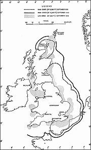
The Chain Home stations were arranged around the British coast, initially in the South and East but later the entire coastline, including the Shetland IslandsShetland Islands
Shetland is a subarctic archipelago of Scotland that lies north and east of mainland Great Britain. The islands lie some to the northeast of Orkney and southeast of the Faroe Islands and form part of the division between the Atlantic Ocean to the west and the North Sea to the east. The total...
. They were first tested in the Battle of Britain
Battle of Britain
The Battle of Britain is the name given to the World War II air campaign waged by the German Air Force against the United Kingdom during the summer and autumn of 1940...
in 1940 when they were able to provide adequate early warning of incoming Luftwaffe
Luftwaffe
Luftwaffe is a generic German term for an air force. It is also the official name for two of the four historic German air forces, the Wehrmacht air arm founded in 1935 and disbanded in 1946; and the current Bundeswehr air arm founded in 1956....
raids. Their early deployment had allowed the U.K. time to develop a well-integrated communication system to direct responses to enemy formations detected.
Chain Home had many limitations. With fixed antennae facing the sea, the Observer Corps
Royal Observer Corps
The Royal Observer Corps was a civil defence organisation operating in the United Kingdom between 29 October 1925 and 31 December 1995, when the Corps' civilian volunteers were stood down....
had to be employed to report aircraft movements once the coast was reached. With detection poor below 5000 ft (1,524 m), Chain Home Low stations were placed between Chain Home stations to detect aircraft down to 2000 ft (609.6 m) but only out to 35 mi (56.3 km) from the coast, about one third the range of Chain Home.
Calibration of the system was carried out initially using a flight of mostly civilian-flown, impressed Avro Rota autogyro
Autogyro
An autogyro , also known as gyroplane, gyrocopter, or rotaplane, is a type of rotorcraft which uses an unpowered rotor in autorotation to develop lift, and an engine-powered propeller, similar to that of a fixed-wing aircraft, to provide thrust...
s flying over a known landmark, the radar then being calibrated so that the position of a target relative to the ground could be read from the position on the display CRT
Cathode ray tube
The cathode ray tube is a vacuum tube containing an electron gun and a fluorescent screen used to view images. It has a means to accelerate and deflect the electron beam onto the fluorescent screen to create the images. The image may represent electrical waveforms , pictures , radar targets and...
. The Rota was used because of its ability to maintain a relatively stationary position over the ground, the pilots learning to fly in small circles while remaining heading into the wind.
During the battle, Chain Home stations — most notably the one at Ventnor
Ventnor
Ventnor is a seaside resort and civil parish established in the Victorian era on the south coast of the Isle of Wight, England. It lies underneath St Boniface Down , and is built on steep slopes and cliffs leading down to the sea...
, Isle of Wight
Isle of Wight
The Isle of Wight is a county and the largest island of England, located in the English Channel, on average about 2–4 miles off the south coast of the county of Hampshire, separated from the mainland by a strait called the Solent...
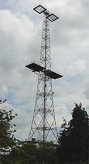
— were attacked several times between 12 and 18 August 1940. On one occasion a section of the radar chain in Kent, including the Dover CH, was put out of action by a lucky hit on the power grid. However, though the wooden huts housing the radar equipment were damaged, the towers survived owing to their open steel girder construction. Because the towers were untoppled and the signals soon restored, the Luftwaffe concluded the stations were too difficult to damage by bombing and left them alone for the remainder of the war. Had the Luftwaffe realised just how essential the radar stations were to British air defences, it is likely that they would have expended great effort to destroy them.
The Chain Home system was dismantled after the war, some of the original sites being used for Chain Home's replacement system, ROTOR
ROTOR
ROTOR was a huge and elaborate air defence radar system built by the British Government in the early 1950s to counter possible attack by Soviet bombers...
, but some of the tall steel Chain Home radar towers remain, converted to new uses. One such 360 feet (109.7 m) high transmitter tower (picture below) can now be found at the BAE Systems
BAE Systems
BAE Systems plc is a British multinational defence, security and aerospace company headquartered in London, United Kingdom, that has global interests, particularly in North America through its subsidiary BAE Systems Inc. BAE is among the world's largest military contractors; in 2009 it was the...
facility at Great Baddow
Great Baddow
Great Baddow is an urban village in the Chelmsford borough of Essex, England. It is close to the county town, Chelmsford and, with a population of over 13,000, is one of the largest villages in the country....
in Essex (2008). It originally stood at Canewdon, and is said to be the only Chain Home tower still in its original, unmodified form.
Among the tallest timber structures ever built in the United Kingdom, at least two of the wooden reception towers were still standing in 1955, at Hayscastle Cross. Unlike the transmitter tower pictured here, those at Hayscastle Cross were guyed.
Use by the Germans
The Germans deployed a passive radarPassive radar
Passive radar systems encompass a class of radar systems that detect and track objects by processing reflections from non-cooperative sources of illumination in the environment, such as commercial broadcast and communications signals...
system, the Kleine Heidelberg Parasit or Heidelberg-Gerät, which allowed them to track British aeroplanes using the radio signals from the Chain Home radars. The "floodlight" nature of the Chain Home transmissions provided a pair of signals which could be used to locate aircraft. The primary signal was received directly by the German receiver from the Chain Home transmitter; the second, weaker, signal was that reflected from the aircraft. The time delay between these two signals established how much longer was the reflected path compared to the direct path, and from geometry this longer path described an ellipse
Bistatic range
Bistatic range refers to the basic measurement of range made by a radar or sonar system with separated transmitter and receiver. The receiver measures the time difference of arrival of the signal from the transmitter directly, and via reflection from the target...
on which the aircraft must lie. The focal points of this ellipse were the transmitting and receiving antennas, and the Germans knew the location of both. A direction-finding antenna searching for the echo could be used to establish where on the ellipse the aircraft was. This system gave the Germans a radar with a range of up to 400 km (248.5 mi; 216 nmi), and an accuracy in range of 1 km (0.621372736649807 mi; 0.539956803455724 nmi) and in bearing of about 1°. The Heidelberg Parasit was not affected by window
Chaff (radar countermeasure)
Chaff, originally called Window by the British, and Düppel by the Second World War era German Luftwaffe , is a radar countermeasure in which aircraft or other targets spread a cloud of small, thin pieces of aluminium, metallized glass fibre or plastic, which either appears as a cluster of secondary...
.
Chain Home sites
- BawdseyBawdseyBawdsey is a village and civil parish in Suffolk, eastern England. Located near Felixstowe, it had an estimated population of 340 in 2007.Bawdsey Manor is notable as the place where radar research took place early in World War II, before moving to Worth Matravers, which is four miles to the west of...
: SuffolkSuffolkSuffolk is a non-metropolitan county of historic origin in East Anglia, England. It has borders with Norfolk to the north, Cambridgeshire to the west and Essex to the south. The North Sea lies to the east...
- BranscombeBranscombeThe Old Bakery, Manor Mill & Forge is a collection of buildings in Branscombe, Seaton, Devon, England. The property has been in the ownership of the National Trust since 1965.The property consists of three buildings: a bakery, a watermill and a forge....
: DevonDevonDevon is a large county in southwestern England. The county is sometimes referred to as Devonshire, although the term is rarely used inside the county itself as the county has never been officially "shired", it often indicates a traditional or historical context.The county shares borders with...
- Brenish: Western Isles
- BrideBride (parish)Bride , named after St. Brigid, is a parish in the Sheading of Ayre and lies in the extreme north of the Isle of Man. The parish lies to the east of Andreas and to the north of Lezayre, bordering the sea to the north and east...
: Isle of ManIsle of ManThe Isle of Man , otherwise known simply as Mann , is a self-governing British Crown Dependency, located in the Irish Sea between the islands of Great Britain and Ireland, within the British Isles. The head of state is Queen Elizabeth II, who holds the title of Lord of Mann. The Lord of Mann is...
- BroadbayPoint, Outer HebridesPoint , also known as the Eye Peninsula, is a peninsula in the Outer Hebrides, Scotland, connected to the rest of the Isle of Lewis by a narrow isthmus, one mile in length and barely 100 metres wide...
: Western Isles - CanewdonRochford Rural DistrictRochford Rural District was a rural district with an area of 146.01 square kilometres in the county of Essex, England. It was created in 1894, in 1897 the parish of Leigh was removed to create the Leigh-on-Sea Urban District. In 1926 the parish of Canvey Island was removed to create the Canvey...
: EssexEssexEssex is a ceremonial and non-metropolitan county in the East region of England, and one of the home counties. It is located to the northeast of Greater London. It borders with Cambridgeshire and Suffolk to the north, Hertfordshire to the west, Kent to the South and London to the south west...
- Castell Mawr: Near LlanrhystudLlanrhystudthumb|300px|right|Llanrhystud, Ceredigion Village and church from the bridleway to Castell-bach.Llanrhystud is a small seaside village on the A487 road in the county of Ceredigion, nine miles south of Aberystwyth, Wales. It is named after the early Christian Welsh saint Rhystud.- External links :***...
, CeredigionCeredigionCeredigion is a county and former kingdom in mid-west Wales. As Cardiganshire , it was created in 1282, and was reconstituted as a county under that name in 1996, reverting to Ceredigion a day later...
, AMES No. 67 - DalbyDalby, Isle of Manthumb|right|250px|The Dalby area is popular for its view of [[Niarbyl, Isle of Man|Niarbyl Bay]]Dalby is a small hamlet on the Isle of Man, located near the western coast. It lies on the A27 Port Erin to Peel road, five miles south of Peel....
: Isle of ManIsle of ManThe Isle of Man , otherwise known simply as Mann , is a self-governing British Crown Dependency, located in the Irish Sea between the islands of Great Britain and Ireland, within the British Isles. The head of state is Queen Elizabeth II, who holds the title of Lord of Mann. The Lord of Mann is...
- Danby Beacon: LealholmLealholmLealholm, sometimes known as Lealholm Bridge, is a small village in the Glaisdale civil parish of the Borough of Scarborough, in North Yorkshire, England. It is sited at a crossing point of the River Esk, in Eskdale which is within the North York Moors National Park. It is by road from the...
, North YorkshireNorth YorkshireNorth Yorkshire is a non-metropolitan or shire county located in the Yorkshire and the Humber region of England, and a ceremonial county primarily in that region but partly in North East England. Created in 1974 by the Local Government Act 1972 it covers an area of , making it the largest...
- Douglas Wood: MonikieMonikieMonikie is a village in Angus, Scotland, north-east of Dundee, and which takes its name from the civil parish of Monikie.-History:The village grew from small beginnings as just one of many hamlets. The other large village in the parish is Newbigging...
, AngusAngusAngus is one of the 32 local government council areas of Scotland, a registration county and a lieutenancy area. The council area borders Aberdeenshire, Perth and Kinross and Dundee City...
- Dover (Swingate)Swingate TransmitterThe Swingate transmitting station is a facility for FM-transmission at Swingate, UK . For many years there were three lattice towers with a height of 111 metres, which were built for Chain Home radar before World War II...
: KentKentKent is a county in southeast England, and is one of the home counties. It borders East Sussex, Surrey and Greater London and has a defined boundary with Essex in the middle of the Thames Estuary. The ceremonial county boundaries of Kent include the shire county of Kent and the unitary borough of...
- DownderryDownderryDownderry is a coastal village in southeast Cornwall, United Kingdom. It is situated 18 miles west of Plymouth and one mile east of Seaton.Downderry has a long beach of light shingle. Dogs are allowed on the beach...
: CornwallCornwallCornwall is a unitary authority and ceremonial county of England, within the United Kingdom. It is bordered to the north and west by the Celtic Sea, to the south by the English Channel, and to the east by the county of Devon, over the River Tamar. Cornwall has a population of , and covers an area of... - Drone Hill: Near ColdinghamColdinghamColdingham is a historic village in Berwickshire, Scottish Borders, on Scotland's southeast coastline, north of Eyemouth.As early as AD 660, Coldingham was the site of a religious establishment of high order, when it is recorded that Etheldreda, the queen of Egfrid, became a nun at the Abbey of...
, BordersScottish BordersThe Scottish Borders is one of 32 local government council areas of Scotland. It is bordered by Dumfries and Galloway in the west, South Lanarkshire and West Lothian in the north west, City of Edinburgh, East Lothian, Midlothian to the north; and the non-metropolitan counties of Northumberland...
- Drytree: Goonhilly DownsGoonhilly DownsGoonhilly Downs is a Site of Special Scientific Interest that forms a raised plateau in the central western area of the Lizard Peninsula in Cornwall, England, UK. Situated just south of Helston and the Naval Air Station at Culdrose, it is famous for its Goonhilly Satellite Earth Station, the...
, CornwallCornwallCornwall is a unitary authority and ceremonial county of England, within the United Kingdom. It is bordered to the north and west by the Celtic Sea, to the south by the English Channel, and to the east by the county of Devon, over the River Tamar. Cornwall has a population of , and covers an area of...
- Dunkirk, KentDunkirk, KentDunkirk is a village and civil parish between Faversham and Canterbury in southeast England.-Toponymy:The origin of the village's name is still not very clear, but it is understood to come from a house called "Dunkirk", lived in by a Fleming from Dunkerque on the border between France and...
- Folly: Nolton, PembrokeshirePembrokeshirePembrokeshire is a county in the south west of Wales. It borders Carmarthenshire to the east and Ceredigion to the north east. The county town is Haverfordwest where Pembrokeshire County Council is headquartered....
- Great BromleyGreat BromleyGreat Bromley is a village and civil parish in the Tendring district of Essex. It lies south of Manningtree and east of Colchester and includes the hamlets of Balls Green and Hare Green...
: EssexEssexEssex is a ceremonial and non-metropolitan county in the East region of England, and one of the home counties. It is located to the northeast of Greater London. It borders with Cambridgeshire and Suffolk to the north, Hertfordshire to the west, Kent to the South and London to the south west...
- GreystoneGreystone-United States:*Greystone Airport, a private airport in Ocala, Florida* Greystone Mansion, Beverly Hills, California mansion built by/for Edward L. Doheny, listed on the NRHP as Doheny Estate/Greystone...
: County DownCounty Down-Cities:*Belfast *Newry -Large towns:*Dundonald*Newtownards*Bangor-Medium towns:...
, Northern IrelandNorthern IrelandNorthern Ireland is one of the four countries of the United Kingdom. Situated in the north-east of the island of Ireland, it shares a border with the Republic of Ireland to the south and west...
, AMES No. 61 - Hawks Tor: PlymouthPlymouthPlymouth is a city and unitary authority area on the coast of Devon, England, about south-west of London. It is built between the mouths of the rivers Plym to the east and Tamar to the west, where they join Plymouth Sound...
, DevonDevonDevon is a large county in southwestern England. The county is sometimes referred to as Devonshire, although the term is rarely used inside the county itself as the county has never been officially "shired", it often indicates a traditional or historical context.The county shares borders with... - Hayscastle Cross: PembrokeshirePembrokeshirePembrokeshire is a county in the south west of Wales. It borders Carmarthenshire to the east and Ceredigion to the north east. The county town is Haverfordwest where Pembrokeshire County Council is headquartered....
- High Steet, DarshamDarshamDarsham is a village in Suffolk, England. It is located approximately north east of Saxmundham. The village is bypassed by the A12 and is served by Darsham railway station, which is approximately one mile away from the village centre, on the Ipswich-Lowestoft East Suffolk Line.The name of the...
, Saxmundham, SuffolkSuffolkSuffolk is a non-metropolitan county of historic origin in East Anglia, England. It has borders with Norfolk to the north, Cambridgeshire to the west and Essex to the south. The North Sea lies to the east...
, IP17 3QD - Hillhead: MemsieMemsieMemsie, Aberdeenshire, is a small community near Fraserburgh. In Memsie there is a very large stone cairn, which has been opened, but nothing found inside. Apart from the cairn, Memsie is near Mormond Hill, which was a very large listening post in the Cold War. These days the former listening post...
, AberdeenshireAberdeenshireAberdeenshire is one of the 32 unitary council areas in Scotland and a lieutenancy area.The present day Aberdeenshire council area does not include the City of Aberdeen, now a separate council area, from which its name derives. Together, the modern council area and the city formed historic...
- KilkeelKilkeelKilkeel is a small town in County Down, Northern Ireland. It is the main fishing port on the Down coast, and its harbour houses one of the largest fishing fleets in Ireland. It had a population of 6,338 people according to the 2001 Census...
: County DownCounty Down-Cities:*Belfast *Newry -Large towns:*Dundonald*Newtownards*Bangor-Medium towns:...
, Northern IrelandNorthern IrelandNorthern Ireland is one of the four countries of the United Kingdom. Situated in the north-east of the island of Ireland, it shares a border with the Republic of Ireland to the south and west...
AMES No. 78 - Kilkenneth: TireeTiree-History:Tiree is known for the 1st century BC Dùn Mòr broch, for the prehistoric carved Ringing Stone and for the birds of the Ceann a' Mhara headland....
, Argyll and ButeArgyll and ButeArgyll and Bute is both one of 32 unitary council areas; and a Lieutenancy area in Scotland. The administrative centre for the council area is located in Lochgilphead.Argyll and Bute covers the second largest administrative area of any Scottish council...
- Loth: HelmsdaleHelmsdaleHelmsdale is a village on the east coast of Sutherland, in the Highland council area of Scotland. The modern village was planned in 1814 to resettle communities that had been removed from the surrounding straths as part of the Highland Clearances....
, SutherlandSutherlandSutherland is a registration county, lieutenancy area and historic administrative county of Scotland. It is now within the Highland local government area. In Gaelic the area is referred to according to its traditional areas: Dùthaich 'IcAoidh , Asainte , and Cataibh...
- Netherbutton: HolmHolm, Mainland OrkneyHolm, pronounced "Ham", is a parish on Mainland, Orkney. It is not to be confused with the many Orkney Islands with "holm" in their name.An adjacent Sound, running between Mainland, and Burray, is also named after Holm. It has since been blocked up by the Churchill Barriers...
, Orkney - NefynNefynNefyn is a small town and community on the north west coast of the Llŷn Peninsula in Gwynedd, Wales, with a population of 2,619. Welsh is the first language of almost 80% of its inhabitants. The A497 road terminates in the town centre.-History:...
: GwyneddGwyneddGwynedd is a county in north-west Wales, named after the old Kingdom of Gwynedd. Although the second biggest in terms of geographical area, it is also one of the most sparsely populated...
, AMES No. 66 - NewchurchNewchurch, KentNewchurch is a village and civil parish in the Shepway District in Kent, England. The village is located on the Romney Marsh, west of Dymchurch...
: KentKentKent is a county in southeast England, and is one of the home counties. It borders East Sussex, Surrey and Greater London and has a defined boundary with Essex in the middle of the Thames Estuary. The ceremonial county boundaries of Kent include the shire county of Kent and the unitary borough of...
- North Cairn: Near StranraerStranraerStranraer is a town in the southwest of Scotland. It lies in the west of Dumfries and Galloway and in the county of Wigtownshire.Stranraer lies on the shores of Loch Ryan on the northern side of the isthmus joining the Rhins of Galloway to the mainland...
, DumfriesDumfriesDumfries is a market town and former royal burgh within the Dumfries and Galloway council area of Scotland. It is near the mouth of the River Nith into the Solway Firth. Dumfries was the county town of the former county of Dumfriesshire. Dumfries is nicknamed Queen of the South...
, AMES No. 60 - NorthamNortham, DevonNortham is a small town in Devon, England, lying north of Bideford and south of Westward Ho!. It is thought to have been the site of an Anglo-Saxon castle, and is said to have been where Hubba the Dane attacked Devon and was repelled . A little over a mile away along the coast is a town called...
: DevonDevonDevon is a large county in southwestern England. The county is sometimes referred to as Devonshire, although the term is rarely used inside the county itself as the county has never been officially "shired", it often indicates a traditional or historical context.The county shares borders with...
- Noss Hill: Shetland IslandsShetland IslandsShetland is a subarctic archipelago of Scotland that lies north and east of mainland Great Britain. The islands lie some to the northeast of Orkney and southeast of the Faroe Islands and form part of the division between the Atlantic Ocean to the west and the North Sea to the east. The total...
- Ottercops Moss: Otterburn, NorthumberlandOtterburn, NorthumberlandOtterburn is a small village in Northumberland, England, northwest of Newcastle Upon Tyne on the banks of the River Rede, near the confluence of the Otter Burn, from which the village derives its name. It lies within the Cheviot Hills about from the Scottish border...
- PevenseyPevenseyPevensey is a village and civil parish in the Wealden district of East Sussex, England. The main village is located 5 miles north-east of Eastbourne, one mile inland from Pevensey Bay. The settlement of Pevensey Bay forms part of the parish.-Geography:The village of Pevensey is located on...
: East SussexEast SussexEast Sussex is a county in South East England. It is bordered by the counties of Kent, Surrey and West Sussex, and to the south by the English Channel.-History:...
- Poling: West SussexWest SussexWest Sussex is a county in the south of England, bordering onto East Sussex , Hampshire and Surrey. The county of Sussex has been divided into East and West since the 12th century, and obtained separate county councils in 1888, but it remained a single ceremonial county until 1974 and the coming...
- Port Mor: TireeTiree-History:Tiree is known for the 1st century BC Dùn Mòr broch, for the prehistoric carved Ringing Stone and for the birds of the Ceann a' Mhara headland....
, Argyll and ButeArgyll and ButeArgyll and Bute is both one of 32 unitary council areas; and a Lieutenancy area in Scotland. The administrative centre for the council area is located in Lochgilphead.Argyll and Bute covers the second largest administrative area of any Scottish council...
- RhuddlanRhuddlanRhuddlan is a town and community in the county of Denbighshire , in north Wales. It is situated to the south of the coastal town of Rhyl and overlooks the River Clwyd. The town gave its name to the Welsh district of Rhuddlan from 1974 to 1996...
: DenbighshireDenbighshireDenbighshire is a county in north-east Wales. It is named after the historic county of Denbighshire, but has substantially different borders. Denbighshire has the distinction of being the oldest inhabited part of Wales. Pontnewydd Palaeolithic site has remains of Neanderthals from 225,000 years...
, AMES No. 65 - Ringstead: Ringstead BayRingstead BayRingstead Bay and the small village of Ringstead are located on the coast in Dorset, southern England. They are accessible by way of a private road that you have to pay £5 to be able to use with a car park at the end near the sea. There is an alternative car park that is free...
, DorsetDorsetDorset , is a county in South West England on the English Channel coast. The county town is Dorchester which is situated in the south. The Hampshire towns of Bournemouth and Christchurch joined the county with the reorganisation of local government in 1974...
- RyeRye, East SussexRye is a small town in East Sussex, England, which stands approximately two miles from the open sea and is at the confluence of three rivers: the Rother, the Tillingham and the Brede...
: East SussexEast SussexEast Sussex is a county in South East England. It is bordered by the counties of Kent, Surrey and West Sussex, and to the south by the English Channel.-History:...
- St. Lawrence, Isle of Wight: Isle of WightIsle of WightThe Isle of Wight is a county and the largest island of England, located in the English Channel, on average about 2–4 miles off the south coast of the county of Hampshire, separated from the mainland by a strait called the Solent...
- Saligo Bay: IslayIslay-Prehistory:The earliest settlers on Islay were nomadic hunter-gatherers who arrived during the Mesolithic period after the retreat of the Pleistocene ice caps. In 1993 a flint arrowhead was found in a field near Bridgend dating from 10,800 BC, the earliest evidence of a human presence found so far...
, Argyll and ButeArgyll and ButeArgyll and Bute is both one of 32 unitary council areas; and a Lieutenancy area in Scotland. The administrative centre for the council area is located in Lochgilphead.Argyll and Bute covers the second largest administrative area of any Scottish council...
- Sango: DurnessDurnessDurness is a huge but remote parish in the northwestern Highlands of Scotland, encompassing all the land between the Moine to the East and the Gualin to the West...
, SutherlandSutherlandSutherland is a registration county, lieutenancy area and historic administrative county of Scotland. It is now within the Highland local government area. In Gaelic the area is referred to according to its traditional areas: Dùthaich 'IcAoidh , Asainte , and Cataibh...
- Scarlett: Isle of ManIsle of ManThe Isle of Man , otherwise known simply as Mann , is a self-governing British Crown Dependency, located in the Irish Sea between the islands of Great Britain and Ireland, within the British Isles. The head of state is Queen Elizabeth II, who holds the title of Lord of Mann. The Lord of Mann is...
- Schoolhill: Porthlethen, AberdeenshireAberdeenshireAberdeenshire is one of the 32 unitary council areas in Scotland and a lieutenancy area.The present day Aberdeenshire council area does not include the City of Aberdeen, now a separate council area, from which its name derives. Together, the modern council area and the city formed historic...
: - SennenSennenSennen is a coastal civil parish and a village in Cornwall, United Kingdom. Sennen village is situated approximately eight miles west-southwest of Penzance....
: CornwallCornwallCornwall is a unitary authority and ceremonial county of England, within the United Kingdom. It is bordered to the north and west by the Celtic Sea, to the south by the English Channel, and to the east by the county of Devon, over the River Tamar. Cornwall has a population of , and covers an area of...
- SkawSkawSkaw is a tiny settlement on the Shetland island of Unst. It is located north of Haroldswick on a peninsula in the northeast corner of the island, and is the most northerly settlement in the United Kingdom...
: UnstUnstUnst is one of the North Isles of the Shetland Islands, Scotland. It is the northernmost of the inhabited British Isles and is the third largest island in Shetland after the Mainland and Yell. It has an area of .Unst is largely grassland, with coastal cliffs...
, Shetland IslandsShetland IslandsShetland is a subarctic archipelago of Scotland that lies north and east of mainland Great Britain. The islands lie some to the northeast of Orkney and southeast of the Faroe Islands and form part of the division between the Atlantic Ocean to the west and the North Sea to the east. The total...
- SouthbourneSouthbourne, DorsetSouthbourne is a suburb of Bournemouth. It is the most easterly part of the borough, between Boscombe and Christchurch, Dorset. The area was previously known as Stourfield....
: DorsetDorsetDorset , is a county in South West England on the English Channel coast. The county town is Dorchester which is situated in the south. The Hampshire towns of Bournemouth and Christchurch joined the county with the reorganisation of local government in 1974...
- Staxton WoldRAF Staxton WoldRAF Staxton Wold is a Royal Air Force radar station near Scarborough in North Yorkshire.The official RAF descriptions states that RAF Staxton Wold has been used as an early warning station since the 3rd Century AD, when it was the site of a warning beacon. It was first used as a radar station in...
: North YorkshireNorth YorkshireNorth Yorkshire is a non-metropolitan or shire county located in the Yorkshire and the Humber region of England, and a ceremonial county primarily in that region but partly in North East England. Created in 1974 by the Local Government Act 1972 it covers an area of , making it the largest...
- StenigotRAF StenigotRAF Stenigot was a World War II radar station situated at Stenigot. near Donington on Bain, Lincolnshire, England.It was part of the Chain Home radar network, intended to provide long range early warning for raids from Luftflotte V and the northern elements of Luftflotte II along the approaches to...
: Louth, LincolnshireLouth, LincolnshireLouth is a market town and civil parish within the East Lindsey district of Lincolnshire, England.-Geography:Known as the "capital of the Lincolnshire Wolds", it is situated where the ancient trackway Barton Street crosses the River Lud, and has a total resident population of 15,930.The Greenwich...
- Stoke Holy CrossStoke Holy CrossStoke Holy Cross is a village in South Norfolk which lies approximately 4 miles south of Norwich.-Geography:It sits on the River Tas. It covers an area of and had a population of 1,568 in 674 households as of the 2001 census....
: NorfolkNorfolkNorfolk is a low-lying county in the East of England. It has borders with Lincolnshire to the west, Cambridgeshire to the west and southwest and Suffolk to the south. Its northern and eastern boundaries are the North Sea coast and to the north-west the county is bordered by The Wash. The county...
- Tannach: WickWick, HighlandWick is an estuary town and a royal burgh in the north of the Highland council area of Scotland. Historically, it is one of two burghs within the county of Caithness, of which Wick was the county town. The town straddles the River Wick and extends along both sides of Wick Bay...
, CaithnessCaithnessCaithness is a registration county, lieutenancy area and historic local government area of Scotland. The name was used also for the earldom of Caithness and the Caithness constituency of the Parliament of the United Kingdom . Boundaries are not identical in all contexts, but the Caithness area is...
- TowerBlackpool TowerBlackpool Tower Eye is a tourist attraction in Blackpool, Lancashire in England which was opened to the public on 14 May 1894. . Inspired by the Eiffel Tower in Paris, it rises to 518 feet & 9 inches . The tower is a member of the World Federation of Great Towers...
: BlackpoolBlackpoolBlackpool is a borough, seaside town, and unitary authority area of Lancashire, in North West England. It is situated along England's west coast by the Irish Sea, between the Ribble and Wyre estuaries, northwest of Preston, north of Liverpool, and northwest of Manchester...
, LancashireLancashireLancashire is a non-metropolitan county of historic origin in the North West of England. It takes its name from the city of Lancaster, and is sometimes known as the County of Lancaster. Although Lancaster is still considered to be the county town, Lancashire County Council is based in Preston...
, AMES No. 64 - Trelanvean: Goonhilly DownsGoonhilly DownsGoonhilly Downs is a Site of Special Scientific Interest that forms a raised plateau in the central western area of the Lizard Peninsula in Cornwall, England, UK. Situated just south of Helston and the Naval Air Station at Culdrose, it is famous for its Goonhilly Satellite Earth Station, the...
, CornwallCornwallCornwall is a unitary authority and ceremonial county of England, within the United Kingdom. It is bordered to the north and west by the Celtic Sea, to the south by the English Channel, and to the east by the county of Devon, over the River Tamar. Cornwall has a population of , and covers an area of...
- Trerew: NewquayNewquayNewquay is a town, civil parish, seaside resort and fishing port in Cornwall, England. It is situated on the North Atlantic coast of Cornwall approximately west of Bodmin and north of Truro....
, CornwallCornwallCornwall is a unitary authority and ceremonial county of England, within the United Kingdom. It is bordered to the north and west by the Celtic Sea, to the south by the English Channel, and to the east by the county of Devon, over the River Tamar. Cornwall has a population of , and covers an area of...
- VentnorVentnorVentnor is a seaside resort and civil parish established in the Victorian era on the south coast of the Isle of Wight, England. It lies underneath St Boniface Down , and is built on steep slopes and cliffs leading down to the sea...
: Isle of WightIsle of WightThe Isle of Wight is a county and the largest island of England, located in the English Channel, on average about 2–4 miles off the south coast of the county of Hampshire, separated from the mainland by a strait called the Solent...
: - Warren: PembrokeshirePembrokeshirePembrokeshire is a county in the south west of Wales. It borders Carmarthenshire to the east and Ceredigion to the north east. The county town is Haverfordwest where Pembrokeshire County Council is headquartered....
- West BeckhamWest BeckhamWest Beckham is a village and a civil parish in the English county of Norfolk The village is west south west of Cromer, north north west of Norwich and north north east of London. The village lies east of the town of Holt. The village is inland from the North Norfolk Coast to the north. The...
, NorfolkNorfolkNorfolk is a low-lying county in the East of England. It has borders with Lincolnshire to the west, Cambridgeshire to the west and southwest and Suffolk to the south. Its northern and eastern boundaries are the North Sea coast and to the north-west the county is bordered by The Wash. The county... - West Prawle: DevonDevonDevon is a large county in southwestern England. The county is sometimes referred to as Devonshire, although the term is rarely used inside the county itself as the county has never been officially "shired", it often indicates a traditional or historical context.The county shares borders with...
- Whale Head: SandaySanday, OrkneySanday is one of the inhabited islands in the Orkney Islands, off the north coast of Scotland. With an area of , it is the third largest of the Orkney Islands. The main centres of population are Lady Village and Kettletoft. Sanday can be reached by Orkney Ferries or plane from Kirkwall on the...
, Orkney IslandsOrkney IslandsOrkney also known as the Orkney Islands , is an archipelago in northern Scotland, situated north of the coast of Caithness...
- Worth MatraversWorth MatraversWorth Matravers is a village and civil parish in the English county of Dorset. The village is situated on the cliffs west of Swanage. It comprises limestone cottages and farm houses and is built around a pond, which is a regular feature on postcards of the Isle of Purbeck.The civil parish stretches...
: SwanageSwanageSwanage is a coastal town and civil parish in the south east of Dorset, England. It is situated at the eastern end of the Isle of Purbeck, approximately 10 km south of Poole and 40 km east of Dorchester. The parish has a population of 10,124 . Nearby are Ballard Down and Old Harry Rocks,...
, DorsetDorsetDorset , is a county in South West England on the English Channel coast. The county town is Dorchester which is situated in the south. The Hampshire towns of Bournemouth and Christchurch joined the county with the reorganisation of local government in 1974...
- WylfaWylfaThe Wylfa Nuclear Power Station is situated just west of Cemaes Bay on the island of Anglesey, North Wales. Its location on the coast provides an excellent cooling source for its operation...
: Isle of Anglesey, AMES No. 76
See also
- Acoustic mirrorAcoustic mirrorAn acoustic mirror is a passive device used to reflect and perhaps to focus sound waves.- Overview :Prior to World War II and the invention of radar, acoustic mirrors were built as early warning devices around the coasts of Great Britain, with the aim of detecting airborne invasions...
- James Atkinson
- Battle of the beamsBattle of the beamsThe Battle of the Beams was a period early in the Second World War when bombers of the German Air Force used a number of increasingly accurate systems of radio navigation for night bombing. British "scientific intelligence" at the Air Ministry fought back with a variety of increasingly effective...
- British military history of World War II
- Chain Home LowChain Home LowChain Home Low was the name of a British radar early warning system, detecting enemy aircraft movement at lower altitudes than and summarily used with the fixed Chain Home system which was operated by the RAF during World War II...
- Civilian Technical CorpsCivilian Technical CorpsThe Civilian Technical Corps was an American quasi-military uniformed organization raised in 1941 in the United States of America, to directly assist with the war effort within the United Kingdom. The Corps was manned by volunteer civilians....
- Ground-controlled interceptionGround-controlled interceptionGround-controlled interception an air defense tactic whereby one or more radar stations are linked to a command communications centre which guides interceptor aircraft to an airborne target. This tactic was pioneered during World War II by the Royal Air Force with the Luftwaffe to follow closely...
- History of radarHistory of radarThe history of radar starts with experiments by Heinrich Hertz in the late 19th century that showed that radio waves were reflected by metallic objects. This possibility was suggested in James Clerk Maxwell's seminal work on electromagnetism...
- ROTORROTORROTOR was a huge and elaborate air defence radar system built by the British Government in the early 1950s to counter possible attack by Soviet bombers...
- Linesman/MediatorLinesman/MediatorLinesman/Mediator was the dual-purpose civil and military radar network in the United Kingdom. Against a background of the Russian H-bomb and supersonic bombers Linesman was the answer to the Cold War defence policies, replacing the earlier ROTOR and Type 80 Master Radar Stations that were the...
- Weedon BecWeedon BecWeedon Bec , usually just called "Weedon", is a large village and parish in the district of Daventry, Northamptonshire, England. It lies close to the source of the River Nene.-Geography:...
location of the 1935 radar experiments
Further reading
- Batt, Reg., The Radar Army: Winning the War of the Airwaves (1991, Robert Hale, London) ISBN 0-7090-4508-5
- Bowen, E.G., Radar Days, Institute of Physics Publishing, Bristol, 1987., ISBN 0-7503-0586-X
- Bragg, Michael., RDF1 The Location of Aircraft by Radio Methods 1935-1945, Hawkhead Publishing, Paisley 1988 ISBN 0-9531544-0-8 The history of ground radar in the UK during World War II
- Brown, Louis., A Radar History of World War II, Institute of Physics Publishing, Bristol, 1999., ISBN 0-7503-0659-9
- Latham, Colin & Stobbs, Anne., Radar A Wartime Miracle, Sutton Publishing Ltd, Stroud 1996 ISBN 0-7509-1643-5 A history of radar in the UK during World War II told by the men and women who worked on it.
- Latham, Colin & Stobbs, Anne., Pioneers of Radar (1999, Sutton, England) ISBN 0-7509-2120-X
- Zimmerman, David., Britain's Shield Radar and the Defeat of the Luftwaffe, Sutton Publishing Ltd, Stroud, 2001., ISBN 0-7509-1799-7
External links
- Deflating British Radar Myths of World War II A comparison of contemporary British and German radar technologies and their use
- National Monuments Record for Bawdsey Chain Home Station English Heritage
- National Monuments Record for Great Bromley Chain Home Station
- National Monuments Record for Canewdon Chain Home Station
- National Monuments Record for Dunkirk Chain Home Station
- National Monuments Record for High Street Chain Home Station
- National Monuments Record for Pevensey Chain Home Station
- National Monuments Record for Rye Chain Home Station,
- National Monuments Record for Ventnor Chain Home Station,
- Early Radar Memories Memories of Sgt. Jean Semple, one of Britain’s pioneer radar operators
- Home of Radar — Bawdsey ManorBawdsey ManorBawdsey Manor stands at a prominent position at the mouth of the River Deben close to the village of Bawdsey in Suffolk, England, about 118 km northeast of London....
, SuffolkSuffolkSuffolk is a non-metropolitan county of historic origin in East Anglia, England. It has borders with Norfolk to the north, Cambridgeshire to the west and Essex to the south. The North Sea lies to the east... - RAF Radar Museum
- RAF High Steet picture
- Life at Darsham - BBC
- 11 Group Stations of the Battle of Britain
- Great Baddow Chain Home Mast & Radar Anniversary
- Early radar development in the UK