

Chain Home Low
Encyclopedia
United Kingdom
The United Kingdom of Great Britain and Northern IrelandIn the United Kingdom and Dependencies, other languages have been officially recognised as legitimate autochthonous languages under the European Charter for Regional or Minority Languages...
radar
Radar
Radar is an object-detection system which uses radio waves to determine the range, altitude, direction, or speed of objects. It can be used to detect aircraft, ships, spacecraft, guided missiles, motor vehicles, weather formations, and terrain. The radar dish or antenna transmits pulses of radio...
early warning system
Early warning radar
An early warning radar is any radar system used primarily for the long-range detection of its targets, i.e., allowing defences to be alerted as early as possible before the intruder reaches its target, giving the defences the maximum time in which to operate...
, detecting enemy aircraft movement at lower altitudes than and summarily used with the fixed Chain Home
Chain Home
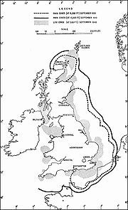
Chain Home was the codename for the ring of coastal Early Warning radar stations built by the British before and during the Second World War. The system otherwise known as AMES Type 1 consisted of radar fixed on top of a radio tower mast, called a 'station' to provide long-range detection of...
system which was operated by the RAF during World War II
World War II
World War II, or the Second World War , was a global conflict lasting from 1939 to 1945, involving most of the world's nations—including all of the great powers—eventually forming two opposing military alliances: the Allies and the Axis...
. Officially, its designation name was AMES Type 2 (Air Ministry Experimental Station
Air Ministry Experimental Station
AMES or Air Ministry Experimental Station was the way of identifying RAF radar types during and after World War II*AMES Type 1, Chain Home - Early Warning*AMES Type 2, Chain Home Low - Early Warning, LOW altitude...
) and used higher power, operating at a shorter wavelength of 1.5 metres than Chain Home
Chain Home
Chain Home was the codename for the ring of coastal Early Warning radar stations built by the British before and during the Second World War. The system otherwise known as AMES Type 1 consisted of radar fixed on top of a radio tower mast, called a 'station' to provide long-range detection of...
. Such systems could be mobile in which units were placed on trucks and could be strategically moved based on enemy movement, giving the RAF a wider option where and when they would engage or not engage the enemy. It was based on CD (Coastal Defence) and CA (Coastal Artillery) radar which were able to detect low-flying aircraft, leading to the development of CHL for the RAF.
Later in World War II, centimetric Chain Home Extra Low (CHEL) radar were often co-sited with CHL sites. As the name implies, these sets provided radar coverage at even lower altitudes than was possible with Chain Home Low.
List of Chain Home Low sites
- AnstrutherAnstrutherAnstruther is a small town in Fife, Scotland. The two halves of Anstruther are divided by a small stream called Dreel Burn. Anstruther lies 9 miles south-southeast of St Andrews. It is the largest community on the stretch of north-shore coastline of the Firth of Forth known as the East Neuk,...
, FifeFifeFife is a council area and former county of Scotland. It is situated between the Firth of Tay and the Firth of Forth, with inland boundaries to Perth and Kinross and Clackmannanshire... - BallymartinBallymartinBallymartin is a small village and townland in County Down, Northern Ireland. In the 2001 Census it had a population of 414 people. It lies within the Newry and Mourne District Council area.Ballymartin is also a townsland in Borris Parish, County Carlow....
, County DownCounty Down-Cities:*Belfast *Newry -Large towns:*Dundonald*Newtownards*Bangor-Medium towns:...
, Northern Ireland - BamburghBamburghBamburgh is a large village and civil parish on the coast of Northumberland, England. It has a population of 454.It is notable for two reasons: the imposing Bamburgh Castle, overlooking the beach, seat of the former Kings of Northumbria, and at present owned by the Armstrong family ; and its...
, NorthumberlandNorthumberlandNorthumberland is the northernmost ceremonial county and a unitary district in North East England. For Eurostat purposes Northumberland is a NUTS 3 region and is one of three boroughs or unitary districts that comprise the "Northumberland and Tyne and Wear" NUTS 2 region... - Bard Hill, HoltHolt, NorfolkHolt is a market town and civil parish in the English county of Norfolk. The town is north of the city of Norwich, west of Cromer and east of King's Lynn. The town is on the route of the A148 King's Lynn to Cromer road. The nearest railway station is in the town of Sheringham where access to the...
, NorfolkNorfolkNorfolk is a low-lying county in the East of England. It has borders with Lincolnshire to the west, Cambridgeshire to the west and southwest and Suffolk to the south. Its northern and eastern boundaries are the North Sea coast and to the north-west the county is bordered by The Wash. The county... - BawdseyBawdseyBawdsey is a village and civil parish in Suffolk, eastern England. Located near Felixstowe, it had an estimated population of 340 in 2007.Bawdsey Manor is notable as the place where radar research took place early in World War II, before moving to Worth Matravers, which is four miles to the west of...
, SuffolkSuffolkSuffolk is a non-metropolitan county of historic origin in East Anglia, England. It has borders with Norfolk to the north, Cambridgeshire to the west and Essex to the south. The North Sea lies to the east... - Beachy HeadBeachy HeadBeachy Head is a chalk headland on the south coast of England, close to the town of Eastbourne in the county of East Sussex, immediately east of the Seven Sisters. The cliff there is the highest chalk sea cliff in Britain, rising to 162 m above sea level. The peak allows views of the south...
, SussexSussexSussex , from the Old English Sūþsēaxe , is an historic county in South East England corresponding roughly in area to the ancient Kingdom of Sussex. It is bounded on the north by Surrey, east by Kent, south by the English Channel, and west by Hampshire, and is divided for local government into West...
– http://www.pastscape.org.uk/hob.aspx?hob_id=1477795 - Beer Head, DevonDevonDevon is a large county in southwestern England. The county is sometimes referred to as Devonshire, although the term is rarely used inside the county itself as the county has never been officially "shired", it often indicates a traditional or historical context.The county shares borders with...
- BembridgeBembridgeBembridge is an affluent village and civil parish located on the easternmost point of the Isle of Wight. It had a population of 3,848 according to the 2001 census of the United Kingdom, leading to claims by residents that Bembridge is the largest village in England, and occasional claims that it is...
, Isle of WightIsle of WightThe Isle of Wight is a county and the largest island of England, located in the English Channel, on average about 2–4 miles off the south coast of the county of Hampshire, separated from the mainland by a strait called the Solent... - BemptonBemptonBempton is a village and civil parish in the East Riding of Yorkshire, England, near the border with North Yorkshire. It is near the North Sea coast and Flamborough Head, and is situated about north of Bridlington. It lies on the B1229 road between Speeton and Flamborough...
, YorkshireYorkshireYorkshire is a historic county of northern England and the largest in the United Kingdom. Because of its great size in comparison to other English counties, functions have been increasingly undertaken over time by its subdivisions, which have also been subject to periodic reform... - Ben Hough, TireeTiree-History:Tiree is known for the 1st century BC Dùn Mòr broch, for the prehistoric carved Ringing Stone and for the birds of the Ceann a' Mhara headland....
- BexhillBexhill-on-SeaBexhill-on-Sea is a town and seaside resort in the county of East Sussex, in the south of England, within the District of Rother. It has a population of approximately 40,000...
, SussexSussexSussex , from the Old English Sūþsēaxe , is an historic county in South East England corresponding roughly in area to the ancient Kingdom of Sussex. It is bounded on the north by Surrey, east by Kent, south by the English Channel, and west by Hampshire, and is divided for local government into West... - Blackhead, County AntrimCounty AntrimCounty Antrim is one of six counties that form Northern Ireland, situated in the north-east of the island of Ireland. Adjoined to the north-east shore of Lough Neagh, the county covers an area of 2,844 km², with a population of approximately 616,000...
, Northern Ireland - Bolt Tail, DevonDevonDevon is a large county in southwestern England. The county is sometimes referred to as Devonshire, although the term is rarely used inside the county itself as the county has never been officially "shired", it often indicates a traditional or historical context.The county shares borders with...
- Boniface Down, Isle of WightIsle of WightThe Isle of Wight is a county and the largest island of England, located in the English Channel, on average about 2–4 miles off the south coast of the county of Hampshire, separated from the mainland by a strait called the Solent...
- Carsaig, Isle of MullIsle of MullThe Isle of Mull or simply Mull is the second largest island of the Inner Hebrides, off the west coast of Scotland in the council area of Argyll and Bute....
- CleadonCleadonCleadon is a suburban village in South Tyneside, North East England in the county of Tyne and Wear. The population of Cleadon is 4,795, and there are a few shops including Bon Appetit Deli, Boutiques store and a Post Office. Cleadon is a short walk from the local East Boldon Metro Station. Nearby...
, County DurhamCounty DurhamCounty Durham is a ceremonial county and unitary district in north east England. The county town is Durham. The largest settlement in the ceremonial county is the town of Darlington... - Clett, Shetland IslandsShetland IslandsShetland is a subarctic archipelago of Scotland that lies north and east of mainland Great Britain. The islands lie some to the northeast of Orkney and southeast of the Faroe Islands and form part of the division between the Atlantic Ocean to the west and the North Sea to the east. The total...
- Cockburnspath, BordersScottish BordersThe Scottish Borders is one of 32 local government council areas of Scotland. It is bordered by Dumfries and Galloway in the west, South Lanarkshire and West Lothian in the north west, City of Edinburgh, East Lothian, Midlothian to the north; and the non-metropolitan counties of Northumberland...
- Cocklaw, PeterheadPeterheadPeterhead is a town in Aberdeenshire, Scotland. It is Aberdeenshire's biggest settlement , with a population of 17,947 at the 2001 Census and estimated to have fallen to 17,330 by 2006....
, AberdeenshireAberdeenshireAberdeenshire is one of the 32 unitary council areas in Scotland and a lieutenancy area.The present day Aberdeenshire council area does not include the City of Aberdeen, now a separate council area, from which its name derives. Together, the modern council area and the city formed historic... - Crannoch Hill, BanffBanffshireThe County of Banff is a registration county for property, and Banffshire is a Lieutenancy area of Scotland.The County of Banff, also known as Banffshire, was a local government county of Scotland with its own county council between 1890 and 1975. The county town was Banff although the largest...
, BanffshireBanffshireThe County of Banff is a registration county for property, and Banffshire is a Lieutenancy area of Scotland.The County of Banff, also known as Banffshire, was a local government county of Scotland with its own county council between 1890 and 1975. The county town was Banff although the largest... - CrasterCrasterCraster is a small fishing village on the Northumbrian coast of England. It has a small and attractive harbour and offers a view northwards along the rocky shore to the spectacular ruins of Dunstanburgh Castle. This is the nearest point of access to the castle and the approach must be made on...
, NorthumberlandNorthumberlandNorthumberland is the northernmost ceremonial county and a unitary district in North East England. For Eurostat purposes Northumberland is a NUTS 3 region and is one of three boroughs or unitary districts that comprise the "Northumberland and Tyne and Wear" NUTS 2 region... - CregneashCregneashCregneash or Cregneish is a remote village situated on Mull Hill in the south of the Isle of Man.Annual Manx festivals are held in Cregneash and it is home to a flock of the rare four-horned Loaghtan sheep. Much of the village forms a "Living Museum" dedicated to the preservation of the...
, Isle of ManIsle of ManThe Isle of Man , otherwise known simply as Mann , is a self-governing British Crown Dependency, located in the Irish Sea between the islands of Great Britain and Ireland, within the British Isles. The head of state is Queen Elizabeth II, who holds the title of Lord of Mann. The Lord of Mann is... - Cresswell, NorthumberlandNorthumberlandNorthumberland is the northernmost ceremonial county and a unitary district in North East England. For Eurostat purposes Northumberland is a NUTS 3 region and is one of three boroughs or unitary districts that comprise the "Northumberland and Tyne and Wear" NUTS 2 region...
- CromartyCromartyThe Royal Burgh of Cromarty is a burgh in Ross and Cromarty, Highland, Scotland.-History:It was previously the county town of the former county of Cromartyshire...
, Ross and CromartyRoss and CromartyRoss and Cromarty is a variously defined area in the Highlands and Islands of Scotland. There is a registration county and a lieutenancy area in current use... - Crustan, Orkney IslandsOrkney IslandsOrkney also known as the Orkney Islands , is an archipelago in northern Scotland, situated north of the coast of Caithness...
- Deerness, Orkney IslandsOrkney IslandsOrkney also known as the Orkney Islands , is an archipelago in northern Scotland, situated north of the coast of Caithness...
- Doonies Hill, Gregness, AberdeenAberdeenAberdeen is Scotland's third most populous city, one of Scotland's 32 local government council areas and the United Kingdom's 25th most populous city, with an official population estimate of ....
- DoverDoverDover is a town and major ferry port in the home county of Kent, in South East England. It faces France across the narrowest part of the English Channel, and lies south-east of Canterbury; east of Kent's administrative capital Maidstone; and north-east along the coastline from Dungeness and Hastings...
– http://www.pastscape.org.uk/hob.aspx?hob_id=1350388 - Downhill, County LondonderryCounty LondonderryThe place name Derry is an anglicisation of the old Irish Daire meaning oak-grove or oak-wood. As with the city, its name is subject to the Derry/Londonderry name dispute, with the form Derry preferred by nationalists and Londonderry preferred by unionists...
, Northern Ireland - Dunderhole Point, near TintagelTintagelTintagel is a civil parish and village situated on the Atlantic coast of Cornwall, United Kingdom. The population of the parish is 1,820 people, and the area of the parish is ....
, CornwallCornwallCornwall is a unitary authority and ceremonial county of England, within the United Kingdom. It is bordered to the north and west by the Celtic Sea, to the south by the English Channel, and to the east by the county of Devon, over the River Tamar. Cornwall has a population of , and covers an area of... - Dunnet HeadDunnet HeadDunnet Head is a peninsula in Caithness, on the north coast of Scotland, that includes the most northerly point of the mainland of Great Britain. The point, known as Easter Head, is at , about westnorthwest of John o' Groats and about from Duncansby Head...
, near ThursoThurso-Facilities:Offices of the Highland Council are located in the town, as is the main campus of North Highland College, formerly Thurso College. This is one of several partner colleges which constitute the UHI Millennium Institute, and offers several certificate, diploma and degree courses from...
, CaithnessCaithnessCaithness is a registration county, lieutenancy area and historic local government area of Scotland. The name was used also for the earldom of Caithness and the Caithness constituency of the Parliament of the United Kingdom . Boundaries are not identical in all contexts, but the Caithness area is... - DunwichDunwichDunwich is a small town in Suffolk, England, within the Suffolk Coast and Heaths AONB.Dunwich was the capital of East Anglia 1500 years ago but the harbour and most of the town have since disappeared due to coastal erosion. Its decline began in 1286 when a sea surge hit the East Anglian coast, and...
, SuffolkSuffolkSuffolk is a non-metropolitan county of historic origin in East Anglia, England. It has borders with Norfolk to the north, Cambridgeshire to the west and Essex to the south. The North Sea lies to the east...
– http://www.pastscape.org.uk/hob.aspx?hob_id=1477319 - EasingtonEasington, North YorkshireEasington is a village in the borough of Redcar and Cleveland and the ceremonial county of North Yorkshire, England. It is located on the A174 near Loftus and inside the North York Moors National Park. It has a pub - the "Tiger Inn" and a church...
, YorkshireYorkshireYorkshire is a historic county of northern England and the largest in the United Kingdom. Because of its great size in comparison to other English counties, functions have been increasingly undertaken over time by its subdivisions, which have also been subject to periodic reform... - Eorodale, Isle of Lewis
- Fair IsleFair IsleFair Isle is an island in northern Scotland, lying around halfway between mainland Shetland and the Orkney islands. It is famous for its bird observatory and a traditional style of knitting.-Geography:...
- FairlightFairlight, East SussexFairlight is a village in East Sussex, England within Rother district, three miles to the east of Hastings. Fairlight is also the name of the civil parish forming part of the Rother district which includes the villages of Fairlight and Fairlight Cove.The village of Fairlight lies on a minor road...
, SussexSussexSussex , from the Old English Sūþsēaxe , is an historic county in South East England corresponding roughly in area to the ancient Kingdom of Sussex. It is bounded on the north by Surrey, east by Kent, south by the English Channel, and west by Hampshire, and is divided for local government into West...
– http://www.pastscape.org.uk/hob.aspx?hob_id=1477107 - Foreness PointForeness PointForeness Point is a low headland on the coast of Kent in England. It extends a short distance into the entrance of the Thames Estuary, on the north coast of Thanet, between Palm Bay in Cliftonville and Botany Bay in Broadstairs. Off the point there is a reef, exposed at low tide, known as Long...
, KentKentKent is a county in southeast England, and is one of the home counties. It borders East Sussex, Surrey and Greater London and has a defined boundary with Essex in the middle of the Thames Estuary. The ceremonial county boundaries of Kent include the shire county of Kent and the unitary borough of...
– http://www.pastscape.org.uk/hob.aspx?hob_id=1477148 - FormbyFormbyFormby is a town and civil parish in the Metropolitan Borough of Sefton in Merseyside, England. It has a population of approximately 25,000....
, LancashireLancashireLancashire is a non-metropolitan county of historic origin in the North West of England. It takes its name from the city of Lancaster, and is sometimes known as the County of Lancaster. Although Lancaster is still considered to be the county town, Lancashire County Council is based in Preston... - Glenarm, County AntrimCounty AntrimCounty Antrim is one of six counties that form Northern Ireland, situated in the north-east of the island of Ireland. Adjoined to the north-east shore of Lough Neagh, the county covers an area of 2,844 km², with a population of approximately 616,000...
, Northern Ireland - Goldsborough, WhitbyWhitbyWhitby is a seaside town, port and civil parish in the Scarborough borough of North Yorkshire, England. Situated on the east coast of Yorkshire at the mouth of the River Esk, Whitby has a combined maritime, mineral and tourist heritage, and is home to the ruins of Whitby Abbey where Caedmon, the...
, YorkshireYorkshireYorkshire is a historic county of northern England and the largest in the United Kingdom. Because of its great size in comparison to other English counties, functions have been increasingly undertaken over time by its subdivisions, which have also been subject to periodic reform... - Great OrmeGreat OrmeThe Great Orme is a prominent limestone headland on the north coast of Wales situated in Llandudno. It is referred to as Cyngreawdr Fynydd in a poem by the 12th century poet Gwalchmai ap Meilyr...
, Llandudno, North Wales - Greian Head, Isle of Barra
- Grutness, SumburghSumburgh HeadSumburgh Head is located at the southern tip of the Shetland Mainland in northernScotland. The head is a 100 m high rocky spur capped by the Sumburgh Head Lighthouse. The Old Norse name was Dunrøstar høfdi, it means "The Head onto the Thunderous Noise", referring to the noise of Sumburgh Roost...
, Shetland IslandsShetland IslandsShetland is a subarctic archipelago of Scotland that lies north and east of mainland Great Britain. The islands lie some to the northeast of Orkney and southeast of the Faroe Islands and form part of the division between the Atlantic Ocean to the west and the North Sea to the east. The total... - HappisburghHappisburghHappisburgh is a village and civil parish in the English county of Norfolk. It is situated off the B1159 coast road from Ingham to Bacton.The civil parish has an area of , although this is declining due to cliff erosion. In the 2001 census, before the creation of Walcott parish, it had a...
, NorfolkNorfolkNorfolk is a low-lying county in the East of England. It has borders with Lincolnshire to the west, Cambridgeshire to the west and southwest and Suffolk to the south. Its northern and eastern boundaries are the North Sea coast and to the north-west the county is bordered by The Wash. The county... - Hartland PointHartland PointHartland Point is a high rocky outcrop of land on the northwestern tip of the Devon coast in England. It is three miles north-west of the village of Hartland. The point marks the western limit of the Bristol Channel with the Atlantic Ocean continuing to the west...
, DevonDevonDevon is a large county in southwestern England. The county is sometimes referred to as Devonshire, although the term is rarely used inside the county itself as the county has never been officially "shired", it often indicates a traditional or historical context.The county shares borders with... - Hawcoat, Barrow in Furness, LancashireLancashireLancashire is a non-metropolitan county of historic origin in the North West of England. It takes its name from the city of Lancaster, and is sometimes known as the County of Lancaster. Although Lancaster is still considered to be the county town, Lancashire County Council is based in Preston...
- Highdown HillHighdown HillHighdown Hill is a prominent hill in the South Downs, as its name suggests, reaching a height of . The summit of the hill and its western slopes lie in the parish of Ferring in the Arun district, while its eastern slopes lie in the borough of Worthing. It is a popular spot for picnickers,...
, AngmeringAngmeringAngmering is a large village and civil parish between Littlehampton and Worthing in West Sussex, England. It is located approximately two miles north of the English Channel; Worthing and Littlehampton are about four miles to the east and west respectively.Angmering railway station is miles away...
, SussexSussexSussex , from the Old English Sūþsēaxe , is an historic county in South East England corresponding roughly in area to the ancient Kingdom of Sussex. It is bounded on the north by Surrey, east by Kent, south by the English Channel, and west by Hampshire, and is divided for local government into West... - HoptonHopton-on-SeaHopton-on-Sea should not be confused with the village of Hopton which is still in Suffolk but near to the Norfolk town of Diss.There is also a British Holidays Caravan Park, named Hopton Holiday Village. There is also a Hopton near Wirksworth in Derbyshire...
, NorfolkNorfolkNorfolk is a low-lying county in the East of England. It has borders with Lincolnshire to the west, Cambridgeshire to the west and southwest and Suffolk to the south. Its northern and eastern boundaries are the North Sea coast and to the north-west the county is bordered by The Wash. The county... - HumberstonHumberstonHumberston is a large village and civil parish to the south of Cleethorpes, North East Lincolnshire...
, LincolnshireLincolnshireLincolnshire is a county in the east of England. It borders Norfolk to the south east, Cambridgeshire to the south, Rutland to the south west, Leicestershire and Nottinghamshire to the west, South Yorkshire to the north west, and the East Riding of Yorkshire to the north. It also borders... - HytheHythe, KentHythe , is a small coastal market town on the edge of Romney Marsh, in the District of Shepway on the south coast of Kent. The word Hythe or Hithe is an Old English word meaning Haven or Landing Place....
, KentKentKent is a county in southeast England, and is one of the home counties. It borders East Sussex, Surrey and Greater London and has a defined boundary with Essex in the middle of the Thames Estuary. The ceremonial county boundaries of Kent include the shire county of Kent and the unitary borough of... - Islivig, Isle of Lewis
- Jacka, PortloePortloePortloe is a small village in Cornwall, United Kingdom situated on the Roseland Peninsula east of Veryan. Portloe currently harbours two full time working fishing vessels, the Jasmine and Katy Lil, both of which fish for crab and lobster in Veryan and Gerrans Bay, along with a fleet of smaller...
, CornwallCornwallCornwall is a unitary authority and ceremonial county of England, within the United Kingdom. It is bordered to the north and west by the Celtic Sea, to the south by the English Channel, and to the east by the county of Devon, over the River Tamar. Cornwall has a population of , and covers an area of... - Kendrom, Kilmaluag, Isle of Skye
- Kete, DaleDale, PembrokeshireDale is a small village and community in Pembrokeshire, West Wales, located on the Dale Peninsula which forms the northern side of the entrance to Milford Haven estuary. The village has 205 inhabitants according to the 2001 census.-History:...
, PembrokeshirePembrokeshirePembrokeshire is a county in the south west of Wales. It borders Carmarthenshire to the east and Ceredigion to the north east. The county town is Haverfordwest where Pembrokeshire County Council is headquartered.... - Kilchiaran, Isle of Islay
- KingswearKingswearKingswear is a village and civil parish in the South Hams area of the English county of Devon. The village is located on the east bank of the tidal River Dart, close to the river's mouth and opposite the small town of Dartmouth...
, DevonDevonDevon is a large county in southwestern England. The county is sometimes referred to as Devonshire, although the term is rarely used inside the county itself as the county has never been officially "shired", it often indicates a traditional or historical context.The county shares borders with... - Kinley Hill, SeahamSeahamSeaham, formerly Seaham Harbour, is a small town in County Durham, situated south of Sunderland and east of Durham. It has a small parish church, St Mary the Virgin, with a late 7th century Anglo Saxon nave resembling the church at Escomb in many respects. St Mary the Virgin is regarded as one of...
, County DurhamCounty DurhamCounty Durham is a ceremonial county and unitary district in north east England. The county town is Durham. The largest settlement in the ceremonial county is the town of Darlington... - The Law, CarnoustieCarnoustieCarnoustie is a town and former police burgh in the council area of Angus, Scotland. It is situated at the mouth of the Barry Burn on the North Sea coast...
, AngusAngusAngus is one of the 32 local government council areas of Scotland, a registration county and a lieutenancy area. The council area borders Aberdeenshire, Perth and Kinross and Dundee City... - Mark's Castle, Land's EndLand's EndLand's End is a headland and small settlement in west Cornwall, England, within the United Kingdom. It is located on the Penwith peninsula approximately eight miles west-southwest of Penzance....
, CornwallCornwallCornwall is a unitary authority and ceremonial county of England, within the United Kingdom. It is bordered to the north and west by the Celtic Sea, to the south by the English Channel, and to the east by the county of Devon, over the River Tamar. Cornwall has a population of , and covers an area of... - Minehead, MineheadMineheadMinehead is a coastal town and civil parish in Somerset, England. It lies on the south bank of the Bristol Channel, north-west of the county town of Taunton, from the border with the county of Devon and in proximity of the Exmoor National Park...
, SomersetSomersetThe ceremonial and non-metropolitan county of Somerset in South West England borders Bristol and Gloucestershire to the north, Wiltshire to the east, Dorset to the south-east, and Devon to the south-west. It is partly bounded to the north and west by the Bristol Channel and the estuary of the... - Mossy Bottom, ShorehamShorehamShoreham is the name of several different places:* Shoreham-by-Sea, West Sussex, UK** Shoreham 1974–1997** New Shoreham 1295–1885* Shoreham, Kent, UK* Shoreham, Michigan, USA...
, West SussexWest SussexWest Sussex is a county in the south of England, bordering onto East Sussex , Hampshire and Surrey. The county of Sussex has been divided into East and West since the 12th century, and obtained separate county councils in 1888, but it remained a single ceremonial county until 1974 and the coming... - Navidale, Helmsdale, Sutherland
- Needles, Isle of Wight
- North Foreland, Kent
- Oxwich, Swansea
- Pen Oliver, Lizard, Cornwall
- Pen y Bryn, Caernarfonshire
- Point of Stoer, Sutherland
- Poling, West Sussex – http://www.pastscape.org.uk/hob.aspx?hob_id=1476574
- Prestatyn, Denbighshire
- Rame Head, Cornwall
- Ramsgate, Kent
- Ravenscar, North Yorkshire
- Roddans Port, County Down, Northern Ireland
- Rodel Park, Rodel, Harris, Western Isles
- Rosehearty, Aberdeenshire
- St Bee's Head, Pembrokeshire
- St Cyrus, Aberdeenshire
- St Twynells, Pembrokeshire
- Sango, Durness, Sutherland
- Saxa Vord, Unst, Shetland
- Shotton, County Durham
- Skendleby, Lincolnshire
- South Ronaldsay, Orkney
- South Stack, Anglesey
- Strumble head, Pembrokeshire
- Swansea Bay, Glamorgan
- Trevose Head, Cornwall
- Truleigh Hill, Bramber, West Sussex – http://www.pastscape.org.uk/hob.aspx?hob_id=1477175
- Ulbster, Wick, Caithness
- Ventnor, Isle of Wight
- Walton on Naze, Essex
- Warden Point,Isle of Sheppey, Kent
- Watsness, Walls, Shetland
- Westburn, Aberdeen
- Westcliff, Portland, Dorset
- Whitehawk, Brighton, East Sussex
- Whitstable, Kent
- Worth Matravers, Swanage, Dorset
See also
- Chain HomeChain HomeChain Home was the codename for the ring of coastal Early Warning radar stations built by the British before and during the Second World War. The system otherwise known as AMES Type 1 consisted of radar fixed on top of a radio tower mast, called a 'station' to provide long-range detection of...
- Air Ministry Experimental StationAir Ministry Experimental StationAMES or Air Ministry Experimental Station was the way of identifying RAF radar types during and after World War II*AMES Type 1, Chain Home - Early Warning*AMES Type 2, Chain Home Low - Early Warning, LOW altitude...
- ROTORROTORROTOR was a huge and elaborate air defence radar system built by the British Government in the early 1950s to counter possible attack by Soviet bombers...
- Linesman/MediatorLinesman/MediatorLinesman/Mediator was the dual-purpose civil and military radar network in the United Kingdom. Against a background of the Russian H-bomb and supersonic bombers Linesman was the answer to the Cold War defence policies, replacing the earlier ROTOR and Type 80 Master Radar Stations that were the...