
Loughrigg Fell
Encyclopedia
Loughrigg Fell is a hill in the central part
of the English
Lake District
. It stands on the end of the long ridge coming down from High Raise over Silver How
towards Ambleside
, and is separated from its neighbours by the depression of Red Bank.
is surrounded by an unusual amount of open water. To the north the River Rothay flows through Grasmere
and Rydal Water
before bending around the eastern side of Loughrigg. On the southern flank the River Brathay runs from Elter Water and is also fed by the outfall from Loughrigg Tarn. The two rivers merge at Clappersgate on the south eastern corner of the fell, just before flowing into Windermere
. The western boundary is formed by Red Bank (535 ft) on the ridge to Silver How. Unnamed becks fall north and south into Grasmere and Elter Water.
Loughrigg has two subsidiary ridges on its eastern flank. Lanty Scar provides the obvious line of ascent from Rydal, while the spur rising over Todd Crag leads up from Clappersgate. There are many areas of woodland on the lower slopes, giving way to a wide expanse of bracken clad knolls and small tarns on the top. The summit is on the western side of the plateau and is identified by an Ordnance Survey
column. Many lower tops also decorate the fell, sometimes to the confusion of visitors. Despite the girdle of lakes only Windermere is visible from the summit. The vista is open to the south over the green and blue country of Furness
, with many fells in view on the other three sides.
The fell is easily accessible, being surrounded by roads on all sides. Ambleside
and the smaller settlements of Skelwith Bridge
, Elterwater
, Grasmere
and Rydal
are all within reach, as is the popular double car park at White Moss Common. Many paths run over the fell including the well known Loughrigg Terrace, a level path with superb views of Grasmere, Helm Crag
and the Fairfield
group. Just beyond the eastern end of the Terrace are some quite remarkable caves, caused by quarrying. They penetrate about 150 feet (45.7 m) into the hillside and are often full of water; there are other small mines on the fell.
-tuff
and volcaniclastic sandstone
of the Lincomb Tarns Formation outcropping on the south eastern slopes. Nearer the summit are intrusions rhyolite
and sills of basaltic andesite
. Drift deposits overlie the north western flanks.
triangulation column beside a large cairn
, both standing out from the turf. The view includes intimate views of the Langdale Pikes and the fells around Grasmere
, together with the Fairfield horseshoe
and the Coniston Fells
. Elter Water, Grasmere and a large part of Windermere
can also be seen.
Loughrigg Fell is on the route of the Windermere Way
, a long distance footpath that circumambulates Windermere.
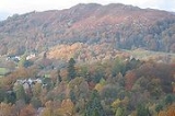
The summit is the middle one of three visible knolls.
Central Fells
The Central Fells are a group of hills in the English Lake District. Reaching their highest point at High Raise , they occupy a broad area to the east of Borrowdale. Perhaps unexpectedly the Central Fells are generally lower than the surrounding hills, the Lake District's general dome-like...
of the English
England
England is a country that is part of the United Kingdom. It shares land borders with Scotland to the north and Wales to the west; the Irish Sea is to the north west, the Celtic Sea to the south west, with the North Sea to the east and the English Channel to the south separating it from continental...
Lake District
Lake District
The Lake District, also commonly known as The Lakes or Lakeland, is a mountainous region in North West England. A popular holiday destination, it is famous not only for its lakes and its mountains but also for its associations with the early 19th century poetry and writings of William Wordsworth...
. It stands on the end of the long ridge coming down from High Raise over Silver How
Silver How
Silver How is a fell in the English Lake District, standing over the village of Grasmere. How, derived from the Old Norse word haugr, is a common local term for a hill or mound.-Topography:...
towards Ambleside
Ambleside
Ambleside is a town in Cumbria, in North West England.Historically within the county of Westmorland, it is situated at the head of Windermere, England's largest lake...
, and is separated from its neighbours by the depression of Red Bank.
Topography
The fellFell
“Fell” is a word used to refer to mountains, or certain types of mountainous landscape, in Scandinavia, the Isle of Man, and parts of northern England.- Etymology :...
is surrounded by an unusual amount of open water. To the north the River Rothay flows through Grasmere
Grasmere (lake)
Grasmere is one of the smaller lakes of the English Lake District, in the county of Cumbria. It gives its name to the village of Grasmere, famously associated with the poet William Wordsworth, which lies immediately to the north of the lake....
and Rydal Water
Rydal Water
Rydal Water is a small lake in the central part of the English Lake District, in the county of Cumbria. It is located near the hamlet of Rydal, between Grasmere and Ambleside in the Rothay Valley....
before bending around the eastern side of Loughrigg. On the southern flank the River Brathay runs from Elter Water and is also fed by the outfall from Loughrigg Tarn. The two rivers merge at Clappersgate on the south eastern corner of the fell, just before flowing into Windermere
Windermere (lake)
Windermere is the largest natural lake in England. It is a ribbon lake formed in a glacial trough after the retreat of ice at the start of the current interglacial. It has been one of the country’s most popular places for holidays and summer homes since the arrival of the Kendal and Windermere...
. The western boundary is formed by Red Bank (535 ft) on the ridge to Silver How. Unnamed becks fall north and south into Grasmere and Elter Water.
Loughrigg has two subsidiary ridges on its eastern flank. Lanty Scar provides the obvious line of ascent from Rydal, while the spur rising over Todd Crag leads up from Clappersgate. There are many areas of woodland on the lower slopes, giving way to a wide expanse of bracken clad knolls and small tarns on the top. The summit is on the western side of the plateau and is identified by an Ordnance Survey
Ordnance Survey
Ordnance Survey , an executive agency and non-ministerial government department of the Government of the United Kingdom, is the national mapping agency for Great Britain, producing maps of Great Britain , and one of the world's largest producers of maps.The name reflects its creation together with...
column. Many lower tops also decorate the fell, sometimes to the confusion of visitors. Despite the girdle of lakes only Windermere is visible from the summit. The vista is open to the south over the green and blue country of Furness
Furness
Furness is a peninsula in south Cumbria, England. At its widest extent, it is considered to cover the whole of North Lonsdale, that part of the Lonsdale hundred that is an exclave of the historic county of Lancashire, lying to the north of Morecambe Bay....
, with many fells in view on the other three sides.
The fell is easily accessible, being surrounded by roads on all sides. Ambleside
Ambleside
Ambleside is a town in Cumbria, in North West England.Historically within the county of Westmorland, it is situated at the head of Windermere, England's largest lake...
and the smaller settlements of Skelwith Bridge
Skelwith Bridge
Skelwith Bridge is a small village in the southern area of the Lake District in Cumbria, North West England. It is located around 3 miles south of Grasmere and is nearby the waterfalls of Skelwith Force and Colwith Force. The nearest lakes to the village are Elter Water to the north-west and...
, Elterwater
Elterwater
Elter Water is a small lake that lies half a mile south-east of the village of Elterwater. Both are situated in the valley of Great Langdale in the English Lake District...
, Grasmere
Grasmere
Grasmere is a village, and popular tourist destination, in the centre of the English Lake District. It takes its name from the adjacent lake, and is associated with the Lake Poets...
and Rydal
Rydal
-Places:Europe* Rydal, Cumbria, a hamlet in the Lake District of England** Rydal Mount, William Wordsworth's house in Lake District* Rydal Penrhos, a private school in North Wales...
are all within reach, as is the popular double car park at White Moss Common. Many paths run over the fell including the well known Loughrigg Terrace, a level path with superb views of Grasmere, Helm Crag
Helm Crag
Helm Crag is a fell in the English Lake District situated in the Central Fells to the north of Grasmere. Despite its low height it sits prominently at the end of a ridge, easily seen from the village...
and the Fairfield
Fairfield (Lake District)
Fairfield is a fell in the English Lake District. It is the highest of a group of hills in the Eastern Fells, standing to the south of the Helvellyn range.-Topography:...
group. Just beyond the eastern end of the Terrace are some quite remarkable caves, caused by quarrying. They penetrate about 150 feet (45.7 m) into the hillside and are often full of water; there are other small mines on the fell.
Geology
The geology is complex with the dacitic welded lapilliLapilli
Lapilli is a size classification term for tephra, which is material that falls out of the air during a volcanic eruption or during some meteorite impacts. Lapilli means "little stones" in Latin. They are in some senses similar to ooids or pisoids in calcareous sediments.By definition lapilli range...
-tuff
Tuff
Tuff is a type of rock consisting of consolidated volcanic ash ejected from vents during a volcanic eruption. Tuff is sometimes called tufa, particularly when used as construction material, although tufa also refers to a quite different rock. Rock that contains greater than 50% tuff is considered...
and volcaniclastic sandstone
Sandstone
Sandstone is a sedimentary rock composed mainly of sand-sized minerals or rock grains.Most sandstone is composed of quartz and/or feldspar because these are the most common minerals in the Earth's crust. Like sand, sandstone may be any colour, but the most common colours are tan, brown, yellow,...
of the Lincomb Tarns Formation outcropping on the south eastern slopes. Nearer the summit are intrusions rhyolite
Rhyolite
This page is about a volcanic rock. For the ghost town see Rhyolite, Nevada, and for the satellite system, see Rhyolite/Aquacade.Rhyolite is an igneous, volcanic rock, of felsic composition . It may have any texture from glassy to aphanitic to porphyritic...
and sills of basaltic andesite
Basaltic andesite
Basaltic andesite is a black volcanic rock containing about 55% silica. Minerals in basaltic andesite include olivine, augite and plagioclase. Basaltic andesite can be found in volcanoes around the world, including in Central America and the Andes of South America. Basaltic andesite is common in...
. Drift deposits overlie the north western flanks.
Summit and view
The highest rocky knoll can be identified by an Ordnance SurveyOrdnance Survey
Ordnance Survey , an executive agency and non-ministerial government department of the Government of the United Kingdom, is the national mapping agency for Great Britain, producing maps of Great Britain , and one of the world's largest producers of maps.The name reflects its creation together with...
triangulation column beside a large cairn
Cairn
Cairn is a term used mainly in the English-speaking world for a man-made pile of stones. It comes from the or . Cairns are found all over the world in uplands, on moorland, on mountaintops, near waterways and on sea cliffs, and also in barren desert and tundra areas...
, both standing out from the turf. The view includes intimate views of the Langdale Pikes and the fells around Grasmere
Grasmere
Grasmere is a village, and popular tourist destination, in the centre of the English Lake District. It takes its name from the adjacent lake, and is associated with the Lake Poets...
, together with the Fairfield horseshoe
Fairfield horseshoe
Fairfield Horseshoe is a classic circular hillwalking ridge walk route starting from Rydal or Ambleside in the English Lake District that takes in all the fells that surround the valley of the Rydal Beck....
and the Coniston Fells
Furness Fells
The Furness Fells are those hills and mountains in the Furness region of Cumbria, England. Historically part of Lancashire, the Furness Fells or High Furness is the name given to the upland part of Furness, that is, that part of Furness lying north of the line between Ulverston and Ireleth...
. Elter Water, Grasmere and a large part of Windermere
Windermere (lake)
Windermere is the largest natural lake in England. It is a ribbon lake formed in a glacial trough after the retreat of ice at the start of the current interglacial. It has been one of the country’s most popular places for holidays and summer homes since the arrival of the Kendal and Windermere...
can also be seen.
Ascents
An easy way up Loughrigg is from the White Moss car park, on the A591 between Grasmere and Rydal Water. This simple walk entails only around 700 ft (213.4 m) of ascent over 1.5 miles (2.4 km). From the car park a trail leads through woods onto Loughrigg Terrace. From the end of the terrace a path leads up left steeply over steps to the wide, undulating top area. Ascents are also possible from any of the surrounding settlements with manifold variations.Loughrigg Fell is on the route of the Windermere Way
Windermere Way
The Windermere Way is a 45 mile circuit of Windermere, a lake in the English Lake District. The route is wholly within the Lake District National Park and takes in the summits of Wansfell, Loughrigg Fell and Gummer's How as well as passing through the towns of Ambleside and Windermere.-History and...
, a long distance footpath that circumambulates Windermere.
The summit is the middle one of three visible knolls.