

Carquinez Strait
Encyclopedia
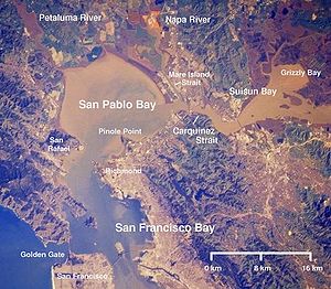
Strait
A strait or straits is a narrow, typically navigable channel of water that connects two larger, navigable bodies of water. It most commonly refers to a channel of water that lies between two land masses, but it may also refer to a navigable channel through a body of water that is otherwise not...
in northern California
California
California is a state located on the West Coast of the United States. It is by far the most populous U.S. state, and the third-largest by land area...
. It is part of the tidal estuary of the Sacramento
Sacramento River
The Sacramento River is an important watercourse of Northern and Central California in the United States. The largest river in California, it rises on the eastern slopes of the Klamath Mountains, and after a journey south of over , empties into Suisun Bay, an arm of the San Francisco Bay, and...
and the San Joaquin
San Joaquin River
The San Joaquin River is the largest river of Central California in the United States. At over long, the river starts in the high Sierra Nevada, and flows through a rich agricultural region known as the San Joaquin Valley before reaching Suisun Bay, San Francisco Bay, and the Pacific Ocean...
rivers as they drain into the San Francisco Bay
San Francisco Bay
San Francisco Bay is a shallow, productive estuary through which water draining from approximately forty percent of California, flowing in the Sacramento and San Joaquin rivers from the Sierra Nevada mountains, enters the Pacific Ocean...
. The strait connects Suisun Bay
Suisun Bay
Suisun Bay is a shallow tidal estuary at in northern California, USA. It lies at the confluence of the Sacramento and San Joaquin Rivers, forming the entrance to the Sacramento-San Joaquin River Delta, an inverted river delta...
, which receives the waters of the combined rivers, with San Pablo Bay
San Pablo Bay
San Pablo Bay is a tidal estuary that forms the northern extension of San Francisco Bay in northern California in the United States. Most of the Bay is shallow; however, there is a deep water channel approximately in mid bay, which allows access to Sacramento, Stockton, Benicia, Martinez, and...
, a northern extension of the San Francisco Bay.
In 1985, an errant humpback whale
Humpback Whale
The humpback whale is a species of baleen whale. One of the larger rorqual species, adults range in length from and weigh approximately . The humpback has a distinctive body shape, with unusually long pectoral fins and a knobbly head. It is an acrobatic animal, often breaching and slapping the...
swam up the Carquinez Strait as far as Rio Vista
Rio Vista
Rio Vista may refer to:* Rio Vista, California* Rio Vista , a neighborhood in Fort Lauderdale, Florida* Rio Vista, a neighborhood in Alpine, New Jersey* Rio Vista, Texas* Rio Vista Park, a park in San Marcos, Texas...
. Named Humphrey the whale
Humphrey the Whale
Humphrey the Whale is arguably the most widely publicized humpback whale in history, having errantly entered San Francisco Bay twice, departing from his Mexico to Alaska migration. This behavior is not normal for any Humpback whale, and Humphrey became well known on national television and press...
by the media, he was successfully turned around and rescued by The Marine Mammal Center
The Marine Mammal Center
The Marine Mammal Center is a private non-profit U.S. organization centered established in 1975 on rescuing, rehabilitating, and releasing injured marine mammals. It also serves as a center for environmental research and education regarding marine mammals, namely cetaceans and pinnipeds...
and other volunteers.
The USNS Glomar Explorer (T-AG-193)
USNS Glomar Explorer (T-AG-193)
GSF Explorer, formerly USNS Glomar Explorer , is a deep-sea drillship platform initially built for the United States Central Intelligence Agency Special Activities Division secret operation Project Azorian to recover the sunken Soviet submarine, K-129, lost in April 1968.The cultural impact of...
was moored for many years at the eastern end of the strait.
Carquinez Strait Powerline Crossing
Carquinez Strait Powerline Crossing
Carquinez Strait Powerline Crossing was the world's first powerline crossing of a large river. It was built in 1901 for a 60 kV powerline operated by Bay Counties Power Companyto deliver electric power to Oakland, California. For this a crossing of Carquinez Strait was required, which has at its...
was the world's first powerline crossing of a large river.
Location
The strait forms part of the border between SolanoSolano County, California
Solano County is a county located in Bay-Delta region of the U.S. state of California, about halfway between San Francisco and Sacramento and is one of the nine San Francisco Bay Area counties. The county's population was reported by the U.S. Census to be 413,344 in 2010...
(to the north) and Contra Costa
Contra Costa County, California
Contra Costa County is a primarily suburban county in the San Francisco Bay Area of the U.S. state of California. As of the 2010 census, it had a population of 1,049,025...
(to the south) counties, and is approximately 15 mi (25 km) north of Oakland
Oakland, California
Oakland is a major West Coast port city on San Francisco Bay in the U.S. state of California. It is the eighth-largest city in the state with a 2010 population of 390,724...
. The cities of Benicia
Benicia, California
Benicia is a waterside city in Solano County, California, United States. It was the first city in California to be founded by Anglo-Americans, and served as the state capital for nearly thirteen months from 1853 to 1854. The population was 26,997 at the 2010 census. The city is located in the San...
and Vallejo
Vallejo, California
Vallejo is the largest city in Solano County, California, United States. The population was 115,942 at the 2010 census. It is located in the San Francisco Bay Area on the northeastern shore of San Pablo Bay...
lie on the north side of the strait, while Martinez
Martinez, California
Martinez is a city and the county seat of Contra Costa County, California, United States. The population was 35,824 at the 2010 census. The downtown is notable for its large number of preserved old buildings...
, Port Costa
Port Costa, California
Port Costa is a census-designated place in Contra Costa County, California, United States. The population was 190 at the 2010 census.-Geography:...
, and Crockett
Crockett, California
Crockett is a census-designated place in Contra Costa County, California, United States. The population was 3,094 at the 2010 census...
sit on the southern coast. The Napa River
Napa River
The Napa River, approximately 55 miles long, is a river in the U.S. state of California. It drains a famous wine-growing region, called the Napa Valley, in the mountains northeast of San Francisco. Milliken Creek is a tributary of the Napa River....
joins the strait, via the short Mare Island Strait
Mare Island
Mare Island is a peninsula in the United States alongside the city of Vallejo, California, about northeast of San Francisco. The Napa River forms its eastern side as it enters the Carquinez Strait juncture with the east side of San Pablo Bay. Mare Island is considered a peninsula because no full...
, near its entrance into San Pablo Bay.
Name
The strait is named after the KarkinKarkin language
Karkin is a name of one sub-group of the indigenous Ohlone people of California, as well as the name of the language they spoke....
("los Carquines" in Spanish), a linguistic division of the Ohlone
Ohlone
The Ohlone people, also known as the Costanoan, are a Native American people of the central California coast. When Spanish explorers and missionaries arrived in the late 18th century, the Ohlone inhabited the area along the coast from San Francisco Bay through Monterey Bay to the lower Salinas Valley...
Native Americans
Native Americans in the United States
Native Americans in the United States are the indigenous peoples in North America within the boundaries of the present-day continental United States, parts of Alaska, and the island state of Hawaii. They are composed of numerous, distinct tribes, states, and ethnic groups, many of which survive as...
who resided on both sides of the strait.
Installations
The California Maritime AcademyCalifornia Maritime Academy
The California Maritime Academy is one of 23 campuses in the California State University system and is one of only seven degree-granting maritime academies in the United States...
is at the western end of the strait on the northern waterfront. The old C&H Sugar
California and Hawaiian Sugar Company
California and Hawaiian Sugar Company was founded in 1906 and operated from 1921 to 1993 as an agricultural cooperative marketing association owned by the member sugar companies in Hawaii...
refinery is located on the southern shore in the small town of Crockett
Crockett, California
Crockett is a census-designated place in Contra Costa County, California, United States. The population was 3,094 at the 2010 census...
.
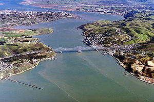
Bridges
The strait is crossed by two highway bridges, the Carquinez BridgeCarquinez Bridge
The Carquinez Bridge refers to parallel bridges spanning the Carquinez Strait, forming part of Interstate 80 between Crockett and Vallejo, California. The name originally referred to a single cantilever bridge built in 1927, helping to form a direct route between San Francisco and Sacramento. A...
on Interstate 80 and the Benicia-Martinez Bridge
Benicia-Martinez Bridge
The Benicia–Martinez Bridge refers to three parallel bridges which cross the Carquinez Strait just west of Suisun Bay; the spans link Benicia, California to the north with Martinez, California to the south...
on Interstate 680
Interstate 680 (California)
Interstate 680 is a north–south Interstate Highway in Northern California. It curves around the eastern cities of the San Francisco Bay Area from San Jose to Interstate 80 at Cordelia, bypassing cities along the eastern shore of San Francisco Bay such as Oakland and Richmond while serving...
. Each highway bridge is composed of two spans.
Interstate 780 connects the two highways on the northern slope of the strait. State Route 4 connects these highways to South of and inland from the strait.
A rail bridge is just east of the Benicia-Martinez bridge, which is used by the Capitol Corridor
Capitol Corridor
The Capitol Corridor is a 168-mile passenger train route operated by Amtrak in California. Because it is fully supported by the state, the Capitol Corridor operates under Amtrak California. It runs from the San Francisco Bay Area to Sacramento, roughly parallel to Interstate 80...
, California Zephyr
California Zephyr
The California Zephyr is a long passenger train route operated by Amtrak in the midwestern and western United States.It runs from Chicago, Illinois, in the east to Emeryville, California, in the west, passing through the states of Illinois, Iowa, Nebraska, Colorado, Utah, Nevada, and California...
, and Coast Starlight
Coast Starlight
The Coast Starlight is a passenger train operated by Amtrak on the West Coast of the United States. It runs from King Street Station in Seattle, Washington, to Union Station in Los Angeles, California. The train's name was formed as a merging of two of Southern Pacific's train names, the Coast...
trains. A rail ferry, with the ferries Contra Costa and Solano
Solano (ferry)
thumb|right|300px|The ferry "Contra Costa", sister ship to "Solano" circa 1917The Solano was a large railroad ferryboat which operated across the Carquinez Strait between Benicia and Port Costa in California....
provided service across the strait, near the location of the current rail bridge, until the rail bridge was built in 1930.
Some tall pylons
Electricity pylon
A transmission tower is a tall structure, usually a steel lattice tower, used to support an overhead power line. They are used in high-voltage AC and DC systems, and come in a wide variety of shapes and sizes...
carrying power line
Electric power transmission
Electric-power transmission is the bulk transfer of electrical energy, from generating power plants to Electrical substations located near demand centers...
s cross the Strait as well.
Ship traffic
The channel is navigable and is used for commercial and military shipping. Deep water ship traffic bound for both the Port of SacramentoPort of Sacramento
The Port of Sacramento is an inland port located northeast of San Francisco, and is centered in one of the richest agricultural regions in the world. Cargo ships access the Port of Sacramento through San Francisco Bay and passage up the Sacramento River and the Sacramento deep water channel...
and the Port of Stockton
Port of Stockton
The Port of Stockton is a major inland deepwater port in Stockton, California located on the San Joaquin River before it joins the Sacramento River to empty into Suisun Bay, eighty miles inland. The port sits on about , and occupies an island in the San Joaquin Delta, and a portion of a...
traverse the strait.
Formation of delta
The narrow gap in the Coast RangeCoast Ranges (California)
The Coast Ranges of California constitute one of the eleven traditional geomorphic provinces of California. They include several but not all mountain ranges along the California coast...
that the strait goes through has led to the formation of the San Joaquin-Sacramento River Delta, an inverted river delta
Inverted river delta
An inverted river delta is special category of river delta in which the narrow end of the delta emerges on the seafront and the wide end is located further inland, so that with respect to the seafront, the locations of both ends of the delta are inverted....
, behind it, a rare geological feature.