

Inverted river delta
Encyclopedia
An inverted river delta is special category of river delta
in which the narrow end of the delta emerges on the seafront and the wide end is located further inland, so that with respect to the seafront, the locations of both ends of the delta are inverted.
 In a typical river delta, the narrow end of the delta is located at the point where a river enters a delta, with a wide fan-shaped sedimentation region extending outward into the body of water into which the river empties. In some rare cases, the delta is located at the waterway's exit from a large, flat valley, yet still inside the valley. The sediment is dropped within the valley and the clear water then exits into a bay or the ocean, so the apex of the delta is at this exit, a configuration said to be inverted from that usually seen. Inverted deltas typically do not last long in geological terms, since they tend to fill up with sediments rather quickly and eventually become normal deltas.
and San Joaquin
rivers in California
. The water from the rivers that drain the entire, large California Central Valley
exit through the Carquinez Strait
, a narrow gap in the Coast Range. An inverted river delta exists behind this strait.
river in Portugal, although due to sedimentation this delta is now only very partially inverted, with the valley now mostly filled with sediment. It is still about 15 km wide and 25 km long, compared with the 2 km wide exit into the sea, and forms a large lagoon with large and very shallow sand banks which go uncovered during low tides. The delta used to be even bigger thousands of years ago.
River delta
A delta is a landform that is formed at the mouth of a river where that river flows into an ocean, sea, estuary, lake, reservoir, flat arid area, or another river. Deltas are formed from the deposition of the sediment carried by the river as the flow leaves the mouth of the river...
in which the narrow end of the delta emerges on the seafront and the wide end is located further inland, so that with respect to the seafront, the locations of both ends of the delta are inverted.
Explanation
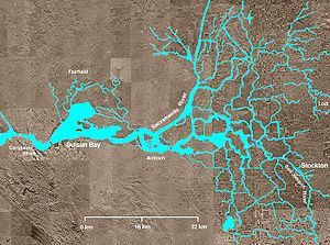
The Sacramento-San Joaquin River Delta
A classic example of an inverted river delta is the Sacramento-San Joaquin River Delta, which lies at the confluence of the SacramentoSacramento River
The Sacramento River is an important watercourse of Northern and Central California in the United States. The largest river in California, it rises on the eastern slopes of the Klamath Mountains, and after a journey south of over , empties into Suisun Bay, an arm of the San Francisco Bay, and...
and San Joaquin
San Joaquin River
The San Joaquin River is the largest river of Central California in the United States. At over long, the river starts in the high Sierra Nevada, and flows through a rich agricultural region known as the San Joaquin Valley before reaching Suisun Bay, San Francisco Bay, and the Pacific Ocean...
rivers in California
California
California is a state located on the West Coast of the United States. It is by far the most populous U.S. state, and the third-largest by land area...
. The water from the rivers that drain the entire, large California Central Valley
California Central Valley
California's Central Valley is a large, flat valley that dominates the central portion of California. It is home to California's most productive agricultural efforts. The valley stretches approximately from northwest to southeast inland and parallel to the Pacific Ocean coast. Its northern half is...
exit through the Carquinez Strait
Carquinez Strait
The Carquinez Strait is a narrow tidal strait in northern California. It is part of the tidal estuary of the Sacramento and the San Joaquin rivers as they drain into the San Francisco Bay...
, a narrow gap in the Coast Range. An inverted river delta exists behind this strait.
The Tagus River
Another example is the delta of the TagusTagus
The Tagus is the longest river on the Iberian Peninsula. It is long, in Spain, along the border between Portugal and Spain and in Portugal, where it empties into the Atlantic Ocean at Lisbon. It drains an area of . The Tagus is highly utilized for most of its course...
river in Portugal, although due to sedimentation this delta is now only very partially inverted, with the valley now mostly filled with sediment. It is still about 15 km wide and 25 km long, compared with the 2 km wide exit into the sea, and forms a large lagoon with large and very shallow sand banks which go uncovered during low tides. The delta used to be even bigger thousands of years ago.