
Campos Verdes
Encyclopedia
| Campos Verdes | |
|---|---|
| State | Goiás Goiás Goiás is a state of Brazil, located in the central part of the country. The name Goiás comes from the name of an indigenous community... |
| Area: | 443.0 km² |
| Population: | 6,331 (IBGE 2007) |
| Urban population: | 5,789 |
| Population density: | 14.33 inhab/km² |
| Population growth rate: | -3,39.% 2000/2007 |
| Elevation: | 420m above sea level |
| Postcode (CEP): | 76515-000 |
| Became a city: | 1989 |
| Mayor: | Noé Afonso Filho |
| Distance to Goiânia Goiânia -Climate:The city has a tropical wet and dry climate with an average temperature of . There's a wet season, from October to April, and a dry one, from May to September. Annual rainfall is around 1,520 mm.... : |
321 km. |
| Website: | none |
| Statistical Microregion: | Porangatu Porangatu Microregion The Porangatu Microregion is a statistical region created by IBGE in north-central Goiás state, Brazil. The most important city is Porangatu... |

Town
A town is a human settlement larger than a village but smaller than a city. The size a settlement must be in order to be called a "town" varies considerably in different parts of the world, so that, for example, many American "small towns" seem to British people to be no more than villages, while...
and municipality
Municipality
A municipality is essentially an urban administrative division having corporate status and usually powers of self-government. It can also be used to mean the governing body of a municipality. A municipality is a general-purpose administrative subdivision, as opposed to a special-purpose district...
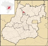
in north Goiás
Goiás
Goiás is a state of Brazil, located in the central part of the country. The name Goiás comes from the name of an indigenous community...
state, Brazil
Brazil
Brazil , officially the Federative Republic of Brazil , is the largest country in South America. It is the world's fifth largest country, both by geographical area and by population with over 192 million people...
. Campos Verdes was known as the emerald capital of Goiás
Goiás
Goiás is a state of Brazil, located in the central part of the country. The name Goiás comes from the name of an indigenous community...
but is fast losing population as the emeralds have run out.
It is located 321 kilometers from the state capital, Goiânia
Goiânia
-Climate:The city has a tropical wet and dry climate with an average temperature of . There's a wet season, from October to April, and a dry one, from May to September. Annual rainfall is around 1,520 mm....
in the Porangatu Microregion
Porangatu Microregion
The Porangatu Microregion is a statistical region created by IBGE in north-central Goiás state, Brazil. The most important city is Porangatu...
. Access from Goiânia
Goiânia
-Climate:The city has a tropical wet and dry climate with an average temperature of . There's a wet season, from October to April, and a dry one, from May to September. Annual rainfall is around 1,520 mm....
is made by GO-080 / Nerópolis
Nerópolis
Nerópolis is a small city and municipality in central Goiás state, Brazil.-Location:The municipality is part of the metropolitan region of Goiânia, which is 42 kilometers to the west. It is nationally known as the city of garlic and sweets...
/ Petrolina de Goiás
Petrolina de Goiás
Petrolina de Goiás is a small town and municipality in central Goiás state, Brazil.-Location:Petrolina de Goiás is located 81 km. almost due north of Goiânia, the state capital. It is 23 km. southwest of São Francisco de Goiás, 23 km. northwest of Ouro Verde de Goiás, 21 km....
/ BR-153 / Jaraguá / Rialma
Rialma
Rialma is a small city and municipality in north-central Goiás state, Brazil.-Location and Geography:Rialma is located across the Rio das Almas from Ceres on the important interstate highway BR-153, which links Anápolis to Belém. It was created as part of the urban area of Ceres, which was also...
/ GO-336 / Itapaci
Itapaci
Itapaci is a small town and municipality in northern Goiás state, Brazil. The population was 16,003 in 2007 . The total area of the municipality was 956.1 km² .-Geography:...
/ GO-154 / Pilar de Goiás
Pilar de Goiás
Pilar de Goiás is a small town and municipality in north-central Goiás state, Brazil.-Location:Pilar is located 252 kilometers north of the state capital, Goiânia in the Ceres Microregion. It is connected to the south of the state, with its main urban centers, by highway BR-153...
/ Santa Terezinha de Goiás
Santa Terezinha de Goiás
Santa Terezinha de Goiás is a small city and municipality in north Goiás state, Brazil. Santa Terezinha is sometimes written as ""Santa Teresinha".-Location:...
.
Municipal boundaries are with:
- North: Mara RosaMara RosaMara Rosa is a small town and municipality in north-central Goiás state, Brazil.-Location:Mara Rosa is located 356 kilometers north of Goiânia in the Porangatu Microregion. It is 11 kilometers east of the Belém-Brasília highway, between the basins of the Araguaia River and the Tocantins River...
- South: Santa Tereza de GoiásSanta Tereza de GoiásSanta Tereza de Goias is a small town and municipality in north Goiás state, Brazil. Santa Tereza de Goiás is often spelled ""Santa Teresa de Goiás"".-Location:Santa Tereza is located in the extreme north of the state 35 km. south of Porangatu...
- East: Alto HorizonteAlto HorizonteAlto Horizonte is a small town and municipality in north Goiás state, Brazil. The population was 3,136 in 2007 and the area of the municipality was 503.7 km².-Location:...
- West: UirapuruUirapuruUirapuru is a small town and municipality in northwestern Goiás state, Brazil.-Location:Uirapuru is in the São Miguel do Araguaia Microregion, west of the important BR-153 highway. It is connected by a paved road to Crixás, 35 kilometers to the south. The distance to the state capital, Goiânia,...
With the discovery of emeralds in the region the population reached almost 50 thousand in the 1990s, but has now dropped to fewer than 7 thousand.
It is the typical example of the mining town that grew overnight, with almost no infrastructure, and soon lost its population due to the disappearance of the mineral that had created its wealth. Today Campos Verdes is known by many as a ghost town.
Campos Verdes began when minerals were discovered in 1981. Attracted by the mines, the first settlers began to arrive, forming a settlement called Garimpo, which at the time was a district of Santa Terezinha de Goiás
Santa Terezinha de Goiás
Santa Terezinha de Goiás is a small city and municipality in north Goiás state, Brazil. Santa Terezinha is sometimes written as ""Santa Teresinha".-Location:...
. In 1987 it was raised to the status of municipality.
Despite the drop in mineral activity there is still agricultural production based on cattle raising (34,500 head in 2006) and plantations with modest production of pineapple, rice, sugarcane, manioc, and corn. In 2006 there were 224 agricultural units with 1,157 hectares under cultivation. There were 25,476 hectares of pasture. Approximately 600 persons were involved in agriculture. There was one bank.
The town had one hospital with 56 beds (2007). The infant mortality rate in 2000 was 41.40. There were 09 schools with 2,704 students. The number of schools and students has dropped dramatically since 2000 when there were 17 schools with 5,358 students. The literacy rate in 2000 was 81.7 Seplan
The score on the Municipal Human Development Index
Human Development Index
The Human Development Index is a composite statistic used to rank countries by level of "human development" and separate "very high human development", "high human development", "medium human development", and "low human development" countries...
was 0.694.
- State ranking: 215 (out of 242 municipalities)
- National ranking: 3,098 (out of 5,507 municipalities)