

Petrolina de Goiás
Encyclopedia
| Petrolina de Goiás | |
|---|---|
| State | Goiás Goiás Goiás is a state of Brazil, located in the central part of the country. The name Goiás comes from the name of an indigenous community... |
| Area: | 540.4 km² |
| Population: | 9,864 (IBGE 2007) |
| Elevation: | 720m above sea level |
| Postcode (CEP): | 75480-000 |
| IBGE statistical microregion: | Anápolis Microregion Anápolis Microregion The Anápolis Microregion is a region of central Goiás state, Brazil, including municipalities surrounding the city of Anápolis. For a map see *Population: 517,221 inhabitants *Cities: 19*Total Area: 8,386.80 km²... |
| Became a city: | 1948 |
| Distance to Goiânia Goiânia -Climate:The city has a tropical wet and dry climate with an average temperature of . There's a wet season, from October to April, and a dry one, from May to September. Annual rainfall is around 1,520 mm.... : |
81 km. |
| Website: | none |
| Coordinates: | 16°05′43"S 49°20′12"W |
Town
A town is a human settlement larger than a village but smaller than a city. The size a settlement must be in order to be called a "town" varies considerably in different parts of the world, so that, for example, many American "small towns" seem to British people to be no more than villages, while...
and municipality
Municipality
A municipality is essentially an urban administrative division having corporate status and usually powers of self-government. It can also be used to mean the governing body of a municipality. A municipality is a general-purpose administrative subdivision, as opposed to a special-purpose district...
in central Goiás
Goiás
Goiás is a state of Brazil, located in the central part of the country. The name Goiás comes from the name of an indigenous community...
state, Brazil
Brazil
Brazil , officially the Federative Republic of Brazil , is the largest country in South America. It is the world's fifth largest country, both by geographical area and by population with over 192 million people...
.
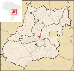
Location
Petrolina de Goiás is located 81 km. almost due north of GoiâniaGoiânia
-Climate:The city has a tropical wet and dry climate with an average temperature of . There's a wet season, from October to April, and a dry one, from May to September. Annual rainfall is around 1,520 mm....
, the state capital. It is 23 km. southwest of São Francisco de Goiás
São Francisco de Goiás
São Francisco de Goiás is a small town and municipality in central Goiás state, Brazil.Municipal boundaries:*North: Jaraguá*South: Petrolina de Goiás*East: Pirenópolis*West: Jesúpolis and Jaraguá...
, 23 km. northwest of Ouro Verde de Goiás
Ouro Verde de Goiás
Ouro Verde de Goiás is a small town and municipality in central Goiás state, Brazil.-Location:Ouro Verde is 63 km. northeast of Goiânia and 31 km west of Anápolis....
, 21 km. north of Damolândia
Damolândia
Damolândia is a small town and municipality in central Goiás state, Brazil.-Highway connections:The distance to Goiânia is 79 km. while the distance to Anápolis is 62 km. Highway connections from Goiânia: GO-462 / Santo Antônio de Goiás / GO-222 / Nova Veneza / GO-416...
, and 23 km. east of Santa Rosa de Goiás
Santa Rosa de Goiás
Santa Rosa de Goiás is a small town and municipality in central Goiás state, Brazil.-Location:Santa Rosa is located 78 km. northwest of the regional center, Anápolis. It is approximately half the distance between Taquaral de Goiás and Petrolina de Goiás. Highway connections are made from...
.
- Distance to regional center (AnápolisAnápolisAnápolis is the third largest city in the State of Goiás in Brazil. It lies in the center of a rich agricultural region and has become a leader in food processing and pharmaceutical plants.-Location and population:...
): 54 km. - Highway connections from GoiâniaGoiânia-Climate:The city has a tropical wet and dry climate with an average temperature of . There's a wet season, from October to April, and a dry one, from May to September. Annual rainfall is around 1,520 mm....
: state highway GO-80 north from GoiâniaGoiânia-Climate:The city has a tropical wet and dry climate with an average temperature of . There's a wet season, from October to April, and a dry one, from May to September. Annual rainfall is around 1,520 mm....
, through Nova VenezaNova VenezaNova Veneza can refer to two towns in Brazil:*Nova Veneza, Goiás, a small town in Goiás state*Nova Veneza, Santa Catarina, a small town in Santa Catarina state...
and Ouro Verde de GoiásOuro Verde de GoiásOuro Verde de Goiás is a small town and municipality in central Goiás state, Brazil.-Location:Ouro Verde is 63 km. northeast of Goiânia and 31 km west of Anápolis....
, and then 23 kilometers northeast. Distancias Rodoviarias
Neighboring municipalities: Santa Rosa de Goiás
Santa Rosa de Goiás
Santa Rosa de Goiás is a small town and municipality in central Goiás state, Brazil.-Location:Santa Rosa is located 78 km. northwest of the regional center, Anápolis. It is approximately half the distance between Taquaral de Goiás and Petrolina de Goiás. Highway connections are made from...
, Jesúpolis
Jesúpolis
Jesúpolis is a small town and municipality in central Goiás state, Brazil. The name literally means "City of Jesus".-Distances and Location:*Distance to Anápolis: 150 km....
, São Francisco de Goiás
São Francisco de Goiás
São Francisco de Goiás is a small town and municipality in central Goiás state, Brazil.Municipal boundaries:*North: Jaraguá*South: Petrolina de Goiás*East: Pirenópolis*West: Jesúpolis and Jaraguá...
, and Ouro Verde de Goiás
Ouro Verde de Goiás
Ouro Verde de Goiás is a small town and municipality in central Goiás state, Brazil.-Location:Ouro Verde is 63 km. northeast of Goiânia and 31 km west of Anápolis....
, Pirenópolis
Pirenópolis
Pirenópolis is a town located in the Brazilian state of Goiás. It is well known for its waterfalls and colonial architecture, and a popular festival involving mounted horses called Festa do Divino Espírito Santo which takes place 45 days after Easter....
, Inhumas
Inhumas
Inhumas is a small city and municipality in central Goiás state, Brazil. The population was 47,361 in a total area of 613.3 km²...
and Itauçu
Itauçu
Itauçu is a small town and municipality in central Goiás state, Brazil.-Location:Itauçu is located 64 km. northwest of the state capital, Goiânia and is part of the Anápolis Microregion...
.
History
Petrolina de Goiás owes its origin to the fertility of the soils of the basin of the Córrego Descoberto. Joaquim Pedro and his family donated lands to create the settlement and build a chapel to honor Santa Maria Eterna. The first name was "Descoberto" but this was changed to "Petrolina" in honor of the founder, Pedro. In 1932 it became a district in the municipality of Jaraguá. In 1943 the name was changed to "Goialina", only to be changed again in 1948 to Petrolina de Goiás.Demographics
- Population density: 18.25 inhab/km² (2007)
- Total population in 2007: 9,864
- Total population in 1980: 12,153
- Population growth rate: -0.37% for 1996/2007
- Urban population: 6,506
- Rural population: 3,358
The economy
The economy is based on agriculture, cattle raising, services, public administration, and small transformation industries.- Number of industrial establishments: 16
- Number of retail establishments: 69
- Dairies: Coop. Agropecuária Regional Rio das Almas Ltda. (22/05/2006)
- Banking establishments: Banco do Brasil S.A., Banco Itaú S.A.
- Automobiles: 991
The cattle herd had 61,800 head in 2007. The main crops cultivated were pineapples, garlic, rice, bananas, manioc, corn, and tomatoes.
Agricultural data 2006
- Number of Farms: 1,015
- Total area: 38,443 ha.
- Area of permanent crops: 1,402 ha. (coconuts, bananas, citrus fruits)
- Area of perennial crops: 4,635 ha. (corn, beans, and rice)
- Area of natural pasture: 27,146 ha.
- Area of woodland and forests: 5,443 ha.
- Persons dependent on farming: 1,400
- Farms with tractors: 123
- Number of tractors: 132 IBGE
Education and Health
There were 9 schools and 2,560 students in 2006. The adult literacy rate was 82.0% (2000) (the national average was 86.4%). There was one hospital with 23 beds in 2007. The infant mortality rate was 18.74 (2000) (the national average was 33.0).Ranking on the Municipal Human Development Index
Human Development Index
The Human Development Index is a composite statistic used to rank countries by level of "human development" and separate "very high human development", "high human development", "medium human development", and "low human development" countries...
- MHDI: 0.733
- State ranking: 133 (out of 242 municipalities)
- National ranking: 2.356 (out of 5,507 municipalities)
All data are from 2000
For the complete list see Frigoletto.com.br
See also
- List of municipalities in Goiás
- Microregions of Goiás