
Burwood railway station, Melbourne
Encyclopedia
Burwood is a railway station on the Alamein line in Melbourne
, Victoria
, Australia
. It is located between Trent Street and Bardolph Street, in the suburb of Glen Iris
. It is located 12.9 kilometres (8 mi) from Flinders Street Station
in the centre of Melbourne
and is in Metcard
Zone 1.
vending machine is located at the entrance to platform 1, able to dispense most ticketing options available and also accept notes and coins. Additional coin-only Metcard and myki
ticket vending machines are located at the entrances to platform 1 and platform 2.
Though Burwood has a large car park, which is often full during the week, it is not a "premium station", and is thus unmanned, with few other facilities. However, it is near to the major thoroughfare of Toorak Road, which gives it easy access to tram routes.
Burwood station is named after Burwood House, which was built by Sir William Palmer
in 1852.
Platform 2:
Melbourne
Melbourne is the capital and most populous city in the state of Victoria, and the second most populous city in Australia. The Melbourne City Centre is the hub of the greater metropolitan area and the Census statistical division—of which "Melbourne" is the common name. As of June 2009, the greater...
, Victoria
Victoria (Australia)
Victoria is the second most populous state in Australia. Geographically the smallest mainland state, Victoria is bordered by New South Wales, South Australia, and Tasmania on Boundary Islet to the north, west and south respectively....
, Australia
Australia
Australia , officially the Commonwealth of Australia, is a country in the Southern Hemisphere comprising the mainland of the Australian continent, the island of Tasmania, and numerous smaller islands in the Indian and Pacific Oceans. It is the world's sixth-largest country by total area...
. It is located between Trent Street and Bardolph Street, in the suburb of Glen Iris
Glen Iris, Victoria
Glen Iris is a suburb in Melbourne, Victoria, Australia, 10 km south-east from Melbourne's central business district. Its Local Government Area are the Cities of Boroondara and Stonnington...
. It is located 12.9 kilometres (8 mi) from Flinders Street Station
Flinders Street Station
Flinders Street Station is the central railway station of the suburban railway network of Melbourne, Victoria, Australia. It is on the corner of Flinders and Swanston Streets next to the Yarra River in the heart of the city, stretching from Swanston Street to Queen Street and covering two city...
in the centre of Melbourne
Melbourne
Melbourne is the capital and most populous city in the state of Victoria, and the second most populous city in Australia. The Melbourne City Centre is the hub of the greater metropolitan area and the Census statistical division—of which "Melbourne" is the common name. As of June 2009, the greater...
and is in Metcard
Metcard
"OneLink" redirects here. For the computer/cable company, see OneLink Communications.Metcard is the brand name of an integrated ticketing system used to access public transport in Melbourne, Australia. It is a universal ticket which allows users to ride on the city's Metlink network, consisting of...
Zone 1.
Facilities
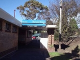
The station has two platforms located either side of the railway tracks. The main station building itself is different to those of most of the other stations on the line, as it is a 1950s-style brick building, compared to the older wooden buildings at most of the other stations. However, on the Alamein bound platform there is an older style wooden building. A large MetcardMetcard
"OneLink" redirects here. For the computer/cable company, see OneLink Communications.Metcard is the brand name of an integrated ticketing system used to access public transport in Melbourne, Australia. It is a universal ticket which allows users to ride on the city's Metlink network, consisting of...
vending machine is located at the entrance to platform 1, able to dispense most ticketing options available and also accept notes and coins. Additional coin-only Metcard and myki
Myki
myki is the contactless smartcard ticketing system being introduced on public transport in Victoria, Australia. myki is designed to replace a number of ticket systems in Victoria, primarily the Metcard and V/Line ticketing systems...
ticket vending machines are located at the entrances to platform 1 and platform 2.
Though Burwood has a large car park, which is often full during the week, it is not a "premium station", and is thus unmanned, with few other facilities. However, it is near to the major thoroughfare of Toorak Road, which gives it easy access to tram routes.
History
Burwood station opened on 30 May 1890, as part of the original Outer Circle line. Confusingly, it was originally called Hartwell, with the current Hartwell station then called Hartwell Hill. It was closed for a brief stint from May 1897 until July 1898, after the closure of the Outer Circle. However, after a public outcry, it soon reopened, first as part of the Deepdene Dasher steam service. It was during this time that Hartwell and Burwood stations acquired their present names, with the switch made on 1 August 1909. In 1927, Burwood became part of the Ashburton line, which was then extended to become the present Alamein line in 1948.Burwood station is named after Burwood House, which was built by Sir William Palmer
William Palmer
William Palmer may refer to: *William Palmer , British Olympic athlete* William Palmer , English cricketer*William Palmer , doctor and multiple murderer...
in 1852.
Platforms, services and connecting services
Platform 1:- Suburban Metro TrainsMetro Trains MelbourneMetro Trains Melbourne is the current franchise operator of the suburban railway network of Melbourne, Australia. Metro Trains Melbourne is a joint venture led by Hong Kong based MTR Corporation together with John Holland Group and United Group Rail .Metro Trains Melbourne operates a fleet of 381...
services to Flinders Street (Peak only). - Suburban Metro Trains services to CamberwellCamberwell railway station, MelbourneCamberwell is a railway station which serves the Belgrave, Lilydale and Alamein lines in the eastern Melbourne suburb of Camberwell, Victoria, Australia...
.
Platform 2:
- Suburban Metro Trains services to Alamein.
- 968 City (Swanston StreetSwanston Street, MelbourneSwanston Street is a major thoroughfare in the centre of Melbourne, Australia. It is historically one of the main streets of central Melbourne, laid out in 1837 as part of the Hoddle Grid, the layout of major streets that makes up the central business district...
) - BelgraveBelgrave, VictoriaBelgrave is a suburb in Melbourne, Victoria, Australia, 35 km east from Melbourne's central business district. Its Local Government Area is the Shire of Yarra Ranges. At the 2006 Census, Belgrave had a population of 4094...
(NightRider service). - Tram route 75Melbourne tram route 75Tram route 75 is a public transport service in Melbourne, Victoria, Australia. It runs from the corner of Spencer Street and La Trobe Street in the city centre to Vermont South in the eastern suburbs....
City (Spencer StreetSpencer Street, MelbourneSpencer Street is a major street in the central business district of Melbourne, Victoria, Australia. It is named for John Spencer, 3rd Earl Spencer, Chancellor of the Exchequer under Lord Melbourne, the Prime Minister of the United Kingdom....
-La Trobe StreetLa Trobe Street, MelbourneLa Trobe Street is a major street in the central business district of Melbourne, Victoria, Australia. It runs roughly from east to west and forms the northern boundary of the CBD ....
) - Vermont SouthVermont South, VictoriaVermont South is a suburb in Melbourne, Victoria, Australia, 20 km east from Melbourne's central business district. Its Local Government Area is the City of Whitehorse. At the 2006 Census, Vermont South had a population of 11,485....
via Flinders StreetFlinders Street, MelbourneFlinders Street is a notable street in Melbourne, Victoria, Australia. Running roughly parallel to the Yarra River, Flinders Street forms the southern edge of the Hoddle Grid. It is exactly one mile in length and one and half chains in width...
, Bridge RoadBridge Road, MelbourneBridge Road is a major shopping strip in Melbourne, Australia. It is best known for its abundance of clothing factory outlets, which makes it a popular tourist attraction...
, Riversdale RoadRiversdale Road, MelbourneRiversdale Road is a major east-west thoroughfare in Melbourne, Australia. It runs from Hawthorn to Box Hill South, and includes the many small shopping areas along it, located in Richmond, Hawthorn, Hawthorn East, Camberwell and Surrey Hills. Beyond Hawthorn, the road was originally called...
, Camberwell Road, Burwood HighwayBurwood HighwayBurwood Highway is a major transportation link with Melbourne's eastern suburbs. It begins in the suburb of Kooyong, Melbourne at the junction of the Monash Freeway as Toorak Road between Monash Freeway and Warrigal Road, and finishes in Belgrave, Victoria in the Dandenong Ranges...
.